Sounds like a driver who quickly went through the stages of 1. saw a cyclist, 2. didn't care, 3. regret.
From observing driving style in NZ, there is a subset of drivers who gravely underestimate how much hitting someone with a car sucks.
08.07.2025 07:12 — 👍 1 🔁 0 💬 0 📌 0
National campaigned on basically a single issue — be spiteful — and they're keeping that promise.
30.06.2025 11:26 — 👍 0 🔁 0 💬 0 📌 0
Painfully obvious to those learning English as second language.
And that is even before you get to the interesting questions, like do ‘foot’ and ‘root’ officially rhyme or not?
25.06.2025 03:52 — 👍 1 🔁 0 💬 0 📌 0
Yeah true, but I expect (at least over here in Auckland) most apartments will be smaller buildings like 5-over-1s and maybe 4-ish storey walk-ups.
23.06.2025 04:04 — 👍 1 🔁 0 💬 1 📌 0
My argument isn’t pro/against arguments (I’m pro), but more pro quiet streets (which in Auckland is considered some dark Eldritch magic that nobody understands). Quiet streets are important, we must have them and in particular, we must have them around apartments.
23.06.2025 03:58 — 👍 1 🔁 0 💬 1 📌 0
And the scheme shows this really well, there is a HUGE difference in space between those tiny boxes on the left, and those huge curves enclosing the street on the right.
23.06.2025 03:58 — 👍 0 🔁 0 💬 1 📌 0
So if you have a small apartment without backyard, it is not that big of a deal because you still have a lot of space.
But on the left side, the lack of space will bite much worse in apartments. For kids it really sucks if they need supervision to literally just go outside.
23.06.2025 03:58 — 👍 0 🔁 0 💬 1 📌 0
Ideally you’d be in a situation like the rightmost side. Even in a house with a large backyard, most space in your home zone is actually the public space around you. This is also where you can interact with a lot more people. Or where you may let your kids play outside.
23.06.2025 03:58 — 👍 0 🔁 0 💬 1 📌 0
People living in apartments end up having no outdoor space within their home zone. While many houses have a backyard, which is outdoors and part of the home zone.
How bad that is depends on target audience — for yuppies is it merely an annoyance. For families it is suffocating.
23.06.2025 01:39 — 👍 0 🔁 0 💬 1 📌 0
That question was framed in the context of current cities, which are a few extra steps to the left on those graphs (there's a lot more cars than in the 1970s).
The opposite framing is that the rightmost graph trivially answers “but where will children play?” for well built neighbourhoods.
23.06.2025 01:11 — 👍 1 🔁 0 💬 1 📌 0

Some street frontage on Nelson Street. Blank wall with parking entrance. This isn’t even an unusually bad example. There’s a few more examples of this on Hobson Street. Perhaps the most egregious recent offender is the new 277 mall in Newmarket.
Like, dude.
22.06.2025 21:51 — 👍 0 🔁 0 💬 0 📌 0

Brighter isn’t always better: How lighting plays a crucial role in making cities feel safe
Good lighting is the difference between a public space you want to be in, and one you avoid.
From thespinoff.co.nz/society/23-0...
This is one of those things that is obvious once it is spelled out. I would love architects and developers to take note. I strongly suspect so-called “ugly” buildings are ugly, because it is aggressively obvious that nobody cared about their exteriors.
22.06.2025 21:51 — 👍 0 🔁 0 💬 1 📌 0
Reminds me of how occasionally a human driven car enters a pre-metro (*) tunnel in Brussels by mistake, I wonder if self driving cars will do that too.
(*) these are partially completed metro tunnels currently used by trams.
22.06.2025 21:41 — 👍 0 🔁 0 💬 0 📌 0

Home zones.
Note the individual apartments on the “heavy traffic” street.
Originally from: Appleyard, D., 1969. “The Environmental Quality of City Streets: The Residents’ Viewpoint.” Journal of the American Planning Association, 35, 84-101.
And that was half a century ago, I wonder if your average suburban street today has any such lines at all.
This chart has a companion, home zones, which explains such questions as:
- Why can’t you raise children in a modern city
- Why are apartments an inferior option to a house
etc.
22.06.2025 21:30 — 👍 1 🔁 0 💬 1 📌 0
YouTube video by Thykka
Dialup modem connecting
youtu.be/jpMrTxMV6E4?...
21.06.2025 13:14 — 👍 0 🔁 0 💬 0 📌 0

The countours on GeoMaps show that the office park on the other side of the motorway is similarly low lying. But it is apparently protected from flooding by the motorway, which is somewhat higher than the surrounding plain.
11.06.2025 22:24 — 👍 0 🔁 0 💬 1 📌 0
It doesn’t have to be a golf course, but most of it needs to be something that doesn’t incur expensive damage from things that are known to happen in flood plains.
11.06.2025 22:24 — 👍 0 🔁 0 💬 1 📌 0

Any local can tell you the answer. Not really. When cyclone Gabrielle hit us, the intersection at the top of that image was under a metre of water.
Here’s the same area on the Auckland Council Flood Viewer.
11.06.2025 22:24 — 👍 0 🔁 0 💬 1 📌 0

Why not put a golf course right next to a rapid transit, and put the new town centre all the way out in Albany?
That decision did not age super well.
Can we turn this area into ‘town centre’ though?
11.06.2025 22:24 — 👍 2 🔁 0 💬 1 📌 0

btw holding income of $75k pa? That seems like… not a lot for such a site.
11.06.2025 09:50 — 👍 1 🔁 0 💬 0 📌 0
🏌️♂️🏌️♀️🏌️⛳🚩
11.06.2025 09:43 — 👍 0 🔁 0 💬 0 📌 0
But since The Avenue doesn’t show up as a separate lot on GeoMaps I guess it is complicated, because it is a private street.
09.06.2025 04:07 — 👍 0 🔁 0 💬 0 📌 0

The thing local buses do there always struck me as weird. They have to do this little loop onto the busway to reach the local bus platforms. And why do we even have those? Can’t buses go around the block via The Avenue and stop there? That seems at least a bit less slow, and would take up less land.
09.06.2025 04:07 — 👍 0 🔁 0 💬 1 📌 0
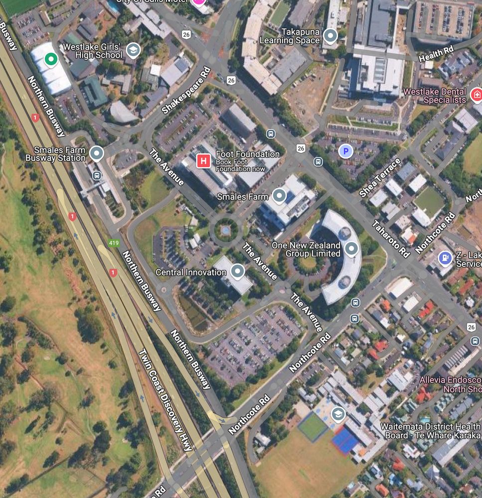

Neighbourhood of Smales Farm station. Google Maps, and Auckland Council GeoMaps.
Notice anything missing on the latter?
09.06.2025 04:07 — 👍 0 🔁 0 💬 1 📌 0
Yeah sometimes if it wants, Auckland Transport can be efficient.
03.06.2025 22:13 — 👍 0 🔁 0 💬 0 📌 0


The lane next to Nelson Street, with the Sugartree apartment complex on the left. Google Streetview, 2019 and 2022. Spot the difference.
03.06.2025 21:58 — 👍 1 🔁 0 💬 0 📌 0

Bonus entry: panoramic view from Verran Corner, one of the highest points in the landscape in the area.
Except they put a fkn fuel station in the way.
02.06.2025 05:01 — 👍 1 🔁 0 💬 0 📌 0

Also Google Streetview. Maybe I should stop more often for pictures.
Collection of hills seen as you go down Eskdale Road. You start at almost 100m of elevation and you go down to 20m. In the distance to the left you can see (I think) the Waitakere ranges, and Greenhite to the right.
02.06.2025 04:57 — 👍 0 🔁 0 💬 1 📌 0

Didn’t find a picture in my collection, so this is from Google Streetview.
View of the city, from Coronation Road.
This is how, back in 2020, I noticed the roof of the then under construction convention centre was on fire.
02.06.2025 04:57 — 👍 0 🔁 0 💬 1 📌 0

This is a Goog
Morning fog rolling in over the Upper Harbour, seen from Verbena Road.
02.06.2025 04:57 — 👍 0 🔁 0 💬 1 📌 0
Governance | Strategic Advice | Campaigns
Former Auckland Councillor
@lievenscheire.bsky.social neemt je mee door de wondere wetenschapswereld, via podcasts, boeken, specials & events!
Nerdland Voor Kleine Nerds: bit.ly/kleinenerds25
Nerdland Festival: www.nerdlandfestival.be
Nerdland website: www.nerdland.be
I'm that YouTuber who taught you how dishwashers work. Guess I'm tryin' out the whole Bluesky thing now.
he/him
https://www.youtube.com/technologyconnections
Tāmaki Makaurau
Surf Lifeguard
Film and TV Safety Officer
Sometimes rides a bike
Menswear writer. Editor at Put This On. Words at The New York Times, The Washington Post, The Financial Times, Esquire, and Mr. Porter.
If you have a style question, search:
https://dieworkwear.com/ | https://putthison.com/start-here/
New Zealand mathematician, writing on climate & the environment at http://planetaryecology.org
data tinkerer with #rstats
occasional economist
Aotearoa NZ
The other “Susie” Wiles AKA NZ’s “Pink Terror”. Microbiologist interested in antibiotic resistance, experimental evolution, and sustainable period products. Also science communicator and lover of bioluminescence & Lego. She/her.
Sewer socialist technocrat.
Infrastructure. Psephology. Shitposting.
Long-suffering Blues fan. 🏳️🌈 but bad at it. He/him. Not a pigeon.
Pōneke/Wellington, Ao/NZ
I write Daring Fireball and created Markdown.
Historians wanna talk like they got something to say | NZ and Australian history, politics, trains, music, sport, higher ed | he/him | "Australian-adjacent person": Melburnian Kiwi in Perth
Plangineer (AICP) when I’m at work, alter ego CityNerd when I’m not. New videos on cities and transportation every Wednesday. http://linktr.ee/CityNerd 🐘 @nerd4cities
Ancient & military historian specializing in the Roman economy and military. PhD from UNC History. More impressive credential is that I have beaten both Dark Souls and Elden Ring.
Blogs at acoup.blog
Auckland City Centre Residents Group
A Voice for Akl's 40,000 City Centre Residents, advocating to improve our City Centre/Pokapū Tāone
City Fans & Fanatics!
Journalist, rider of bikes, cooker of food, seeker of joy. Dad-DJ. Cosmopolitan.
Transit planner, urbanism dork, cat fan.
Freelance writer and editor, full-time silly sausage. Books, bikes, better places, beastly puns. She/ her/ the cats’ mother. Based in Tāmaki Makaurau, aka New Auck City.
15-minute cities advocacy | Urbanism | Sustainability | 🇳🇱🇳🇿
Views are my own
📍Ōtepoti Dunedin, NZ
Person who rides a bike, in New Zealand. Believes we are all better off when more people ride, more often.
Insightful economic commentary, thoughts on transport and cities, and 80s heavy metal. Dad, Pākehā, afloofianado