Trump's vs. Putin's Approval Ratings in Europe, 2026
#Trump #Putin
10.02.2026 17:10 — 👍 0 🔁 0 💬 0 📌 0

Happy Valley-Goose Bay: -22°C (53°N)
Dublin: 2°C (53°N)
The Gulf Stream creates 20-24°C gaps across the entire North Atlantic.
vividmaps.com/gulf-stream-...
#climate #atlantic
08.02.2026 15:36 — 👍 0 🔁 0 💬 0 📌 0

The most common natural disasters across the United States.
#UnitedStates
08.02.2026 15:33 — 👍 0 🔁 0 💬 0 📌 0

27 countries write in scripts they invented. Everyone else borrowed.
vividmaps.com/map-countrie...
#languages
06.02.2026 16:02 — 👍 2 🔁 0 💬 0 📌 0
YouTube video by Vivid Maps
Immigration by Country: A World Map of Foreign-Born Populations
Immigration by Country: A World Map of Foreign-Born Populations www.youtube.com/watch?v=JUBN...
#immigration
06.02.2026 16:00 — 👍 0 🔁 0 💬 0 📌 0

Housing prices in 2000 vs 2026, adjusted for inflation.
Key findings:
→ 2000: Zero states above $200k average
→ 2026: Only MS and WV below $200k
→ Hawaii: +122% above inflation
→ Louisiana: Only state with negative real growth. vividmaps.com/housing-pric...
#unitedstates #realestate
06.02.2026 15:59 — 👍 0 🔁 0 💬 0 📌 0

U.S. states in classical Latin:
New York → Novum Eboracum (Eboracum = Roman York)
Pennsylvania → Silvānia Penni
Rhode Island → Insula Rhodēnsis
Vermont → Mons Viridis
Massachusetts → Massaciussēta
Idaho → Idahum
vividmaps.com/united-state...
#unitedstates #romanempire
03.02.2026 16:57 — 👍 0 🔁 0 💬 0 📌 0

The Best World Atlases in 2026
vividmaps.com/united-state...
#atals #maps
03.02.2026 16:55 — 👍 0 🔁 0 💬 0 📌 0

The linguistics of U.S. state names:
🟢 Indigenous (25): Algonquian, Siouan, Iroquoian + others
🟡 Spanish (5): Florida, California, Nevada, New Mexico, Colorado
🔵 English (5): New York, New Jersey, New Hampshire, Indiana, Washington
vividmaps.com/us-states-na...
02.02.2026 15:58 — 👍 0 🔁 0 💬 0 📌 0
YouTube video by Vivid Maps
America's Safest vs Most Dangerous States: 2025 Crime Data Mapped
America's Safest vs Most Dangerous States
www.youtube.com/watch?v=Q3oA...
#unitedstates #crime
01.02.2026 13:20 — 👍 0 🔁 0 💬 0 📌 0

Coordinate Converter: DMS ↔ Decimal Degrees
vividmaps.com/convert-lati...
01.02.2026 13:19 — 👍 0 🔁 0 💬 0 📌 0

How much land does food need?
Beef: 326 m²/kg
Chicken: 12 m²/kg
Peas: 7.5 m²/kg
Tomatoes: 0.8 m²/kg
The efficiency gap between animal products and plant foods is massive.
vividmaps.com/global-agric...
#agriculture
31.01.2026 15:32 — 👍 2 🔁 0 💬 0 📌 0
YouTube video by Vivid Maps
When Countries Hit 30 Million People — From Ancient Times to the Future
When Countries Hit 30 Million People — From Ancient Times to the Future
www.youtube.com/watch?v=kZNu...
31.01.2026 15:31 — 👍 0 🔁 0 💬 0 📌 0

101.9 million hectares of new cropland worldwide from 2000-2019.
Africa: +53.2M ha
South America: +37.1M ha
Europe: +0.9M ha
Southeast Asia: -1.6M ha (only region that shrank)
vividmaps.com/global-agric...
#croplands
31.01.2026 15:30 — 👍 0 🔁 0 💬 0 📌 0


Europe's economic power in 1938 tells you everything about the war that followed.
Germany: $77.2B ($10,500 per capita)
USSR: $76.0B ($4,500 per capita)
vividmaps.com/gdp-before-s...
30.01.2026 19:06 — 👍 0 🔁 0 💬 0 📌 0


☀️ Solar: >6.5 kWh/m²/day in Southwest (CA, NV, AZ, NM, TX)
🌬️ Wind: >10 m/s at 100m height (coastal CA, Great Lakes, Rockies, Atlantic)
vividmaps.com/us-solar-win...
#unitedstates #solarenergy #windenergy
29.01.2026 17:38 — 👍 0 🔁 0 💬 0 📌 0

Just mapped where all 2.5 billion Christians actually live.
Africa: 754M (!)
South America: 620M
Europe: 552M
Asia: 417M
N. America: 272M
vividmaps.com/christianity...
#christianity
28.01.2026 18:07 — 👍 0 🔁 0 💬 0 📌 0
YouTube video by Vivid Maps
3D County Borders of the U.S. Based on Elevation, Rainfall & Population
3D County Borders of the U.S. Based on Elevation, Rainfall & Population
www.youtube.com/watch?v=YotC...
#maps
28.01.2026 18:06 — 👍 1 🔁 0 💬 0 📌 0

Russia is 2.4 miles from the USA in the Bering Strait.
Big Diomede (Russia) and Little Diomede (Alaska) sit on different sides of the International Date Line.
vividmaps.com/russia-usa-d...
26.01.2026 17:04 — 👍 0 🔁 0 💬 0 📌 0

31 countries have official state religions:
Islam: 19 (Morocco, Saudi Arabia, Egypt, Malaysia...)
Christianity: 7 (England, Denmark, Greece, Malta...)
Buddhism: 4 (Thailand, Cambodia, Sri Lanka, Bhutan)
Judaism: 1 (Israel)
vividmaps.com/countries-of...
25.01.2026 17:53 — 👍 0 🔁 0 💬 0 📌 0

The land doesn't stop where the water starts. Underwater, the continental shelf can extend over 100 miles before dropping into deep ocean. vividmaps.com/us-continent...
23.01.2026 21:05 — 👍 1 🔁 0 💬 0 📌 0

The North Pole paradox: it belongs to everyone and no one. 6 nations claim surrounding Arctic waters, with Russia asserting the largest area at 4.8M sq km (1.85M sq mi), followed by Canada at 4M sq km (1.54M sq mi) and Denmark (Greenland) at 2.2M sq km (843,345 sq mi). vividmaps.com/who-controls...
20.01.2026 18:52 — 👍 2 🔁 0 💬 0 📌 0

Every city that had more than 100,000 people in 1700.
vividmaps.com/largest-citi...
19.01.2026 16:38 — 👍 0 🔁 0 💬 0 📌 0

Maine 44.9, Utah 32.5. NH aged 6.5 years since 2000, ND aged 0.5 years. Migration drives the difference. vividmaps.com/us-median-ag...
#unitedstates #demographics
17.01.2026 15:17 — 👍 0 🔁 0 💬 0 📌 0

Romans took Greece in 146 BC. That's 173 years before Augustus became emperor. After the 395 split, Greece stayed with the east. vividmaps.com/roman-empire...
#RomanEmpire #history
15.01.2026 17:28 — 👍 0 🔁 0 💬 0 📌 0

Greenland's geography connects directly to economics and geopolitics. At 2.16 million km² (836,330 mi²), it's larger than Mexico but home to only 57,000 people. The ice sheet covering 80% of the island is retreating, exposing 36.2 million tonnes of rare-earth. vividmaps.com/greenlands-s...
13.01.2026 17:42 — 👍 1 🔁 0 💬 0 📌 0
YouTube video by Vivid Maps
Canada's Territorial Journey from Dispersed Colonies to Modern Nation
Canada's Territorial Journey from Dispersed Colonies to Modern Nation
www.youtube.com/watch?v=iqyT...
#canada
13.01.2026 17:40 — 👍 0 🔁 0 💬 0 📌 0

German propaganda leaflet from May 1944 mocked Allies for taking 8 months to advance 123 km (76 mi) through Italian mountains. vividmaps.com/why-frontlin...
#war
07.01.2026 19:16 — 👍 0 🔁 0 💬 0 📌 0

North American wolf subspecies then vs now. Used to have 23 types spread everywhere. Now most are gone or pushed to remote northern areas. Six is confirmed extinct. vividmaps.com/north-americ...
#wolves #northamerica #unitedstates #canada #mexico #animals
06.01.2026 20:35 — 👍 0 🔁 0 💬 0 📌 0
➥ Old Photos, Pics, Paintings, Maps
➥ Docs from Ottoman Empire Archives
➥ Historical Letters, Writings, Poems, Memoirs, Books, Real Human Stories: / Blog: https://ottoman-history-page.blogspot.com
➥ instagram.com/tarihe.seyahat
Contributor @the-downballot.com.
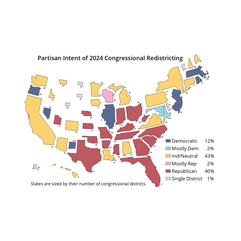
Democracy, voting rights, redistricting, and maps.
Cartography and graphics @postgraphics.bsky.social | Big ol' fan of @wfmu.bsky.social
https://moriartymaps.com/
Surprised historian, not surprised eels.
Doctor of medieval things. Talkin’ eels, history, and maps. Spaniel mourner. Alt-text artist.
I draw custom maps and artwork on commission:
https://surprisedeelmaps.com/
Support me here: patreon.com/SurprisedEel
Mountains and websites; maps and birds; context collapse. Projects: https://subject.space/. Work: Data, research and technology for investigations @bellingcat.com. Personal account, posts/opinions are my own. New York via Amsterdam and Oregon.
Interactive weather map and hurricane tracker.
Get our app 👉 https://zoom.earth/app
🗳️ Mapping UK Elections & Collating Polling Data
nowcast / posters / much more @ electionmaps.uk
support my work @ https://ko-fi.com/electionmapsuk
Data, maps, and satellite imagery 🛰🌻🔭
viewsfromabove.bradyafrick.com
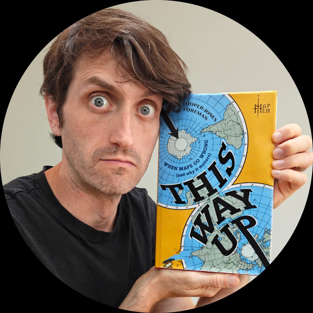
‘This Way Up: When Maps Go Wrong’ (the MAP MEN BOOK) is available now: https://lnk.to/mapmen 🗺️ 📕
Professional chart looker-atter. Author of "The Big Picture" and co-author of "The Big Book of Dashboards." James Jamerson disciple.
official Bluesky account (check username👆)
Bugs, feature requests, feedback: support@bsky.app