Footage from the same location.
Warning: GRAPHIC
Video: anadoluimages.com/p/rescuers-s...
Video: t.me/qudsfeed/400...
Video: instagram.com/p/DUdKSwbDVLS/
Video: t.me/qudsradiofm1...
08.02.2026 00:20 — 👍 1 🔁 0 💬 1 📌 0

ISPT1669 – December 11, 2023
Shortly before 7:43 AM on Monday, December 11th 2023, a series of alleged Israeli airstrikes hit six homes belonging to the extended Salem family in Sheikh Radwan, killing at least 102 civilians. Airw...
The houses were likely hit by Israeli strike(s) on 11 Dec. 2023, more than 2 years ago. An Airwars report found the names of 102 Palestinians, reportedly killed in the attack: airwars.org/civilian-cas...
That report was also cited in the NSM-20 document.
08.02.2026 00:20 — 👍 1 🔁 0 💬 1 📌 0
Yinon Magal, a right-wing Israeli media personality, has also now (7 Feb.) posted the video of the explosion: t.me/yinonews/50520
07.02.2026 23:48 — 👍 0 🔁 0 💬 0 📌 0


MK-84 2,000-pound bomb with a JDAM kit hitting a building in Gaza after an IDF notice.
Bellingcat recently asked the IDF about the lack of evacuation distances in public evacuation notices in Gaza, which are included in notices in Lebanon, so interesting to see a 100m distance in the notice here.
06.02.2026 18:05 — 👍 45 🔁 15 💬 1 📌 1

An image with annotations that shows where the point-of-view was filmed (yellow), where the individual is laying on the ground (red), and IDF forward operating base on Tell Ali Muntar (green).
Geolocation of an individual that was shot on al-Mansoura Street, approx 317,18 meters from the IDF-communicated Yellow Line, within the field of view of the Israeli forward position established on the historical site known as Tell Ali Muntar in Shejaiya, 31.498614, 34.464652.
07.02.2026 16:40 — 👍 9 🔁 4 💬 1 📌 0

The clearing visible to the NE on the Sentinel imagery, appears to be right at the IDF-communicated yellow line (idf.il/158008/) as well as partly to the north of it.
2 approx. locations of new clearing, highlighted above, are annotated here.
06.02.2026 23:53 — 👍 2 🔁 0 💬 1 📌 0
Sentinel satellite imagery shows the destroyed reservoir on 3 Feb., compared to 24 Jan.
More clearing, including possibly at/around the under construction Rafah industrial "craft" zone is also visible.
bsky.app/profile/anno...
06.02.2026 23:53 — 👍 2 🔁 0 💬 1 📌 0

Made in the USA: How American-Built Weapons Have Wrought Destruction in Gaza - bellingcat
Bellingcat has identified scores of incidents where remnants from munitions made in the US have been found after Israeli strikes in Gaza.
American-made munitions have played a significant role in Israel’s operations in Gaza. Bellingcat has collated scores of incidents where the remnants of US-made munitions have been found in the aftermath of Israeli strikes. Read here: www.bellingcat.com/news/2026/01...
04.02.2026 16:52 — 👍 400 🔁 188 💬 11 📌 10
Media upload.
Source: x.com/ytirawi/stat...
02.02.2026 20:55 — 👍 3 🔁 0 💬 1 📌 1

The video is filmed from close to the Israeli military base, which is located next to the former GHF Site 3.
Also not too far from recent ground clearing by the Israeli military in the area.
Ref. photo: zawayanet.com/p/5219
Satellite image: Sentinel 24 Jan. 2026
@geoconfirmed.org
02.02.2026 20:55 — 👍 2 🔁 0 💬 1 📌 0

Geolocation| Israeli forces blow up the Turkish Moraj Water Station in northern #Rafah
31.311889, 34.263417
w/ verification help from @fdov21.bsky.social
Video: x.com/ytirawi/stat...
02.02.2026 20:55 — 👍 7 🔁 3 💬 1 📌 3

Geolocation drawing of the Israeli airstrike today on a a condolence gathering at the Abu Al-Rous family home in Nuseirat camp.
Aftermath of a a condolence gathering at the Abu Al-Rous family home being hit by an Israeli airstrike, geolocated in Nuseirat refugee camp ~ 31.446015, 34.389838.
02.02.2026 19:53 — 👍 6 🔁 3 💬 1 📌 0


Based on the logo on the vehicles they appear to be part of the European Union Border Assistance Mission to Rafah.
Logo reference: eeas.europa.eu/eubam-rafah_en
02.02.2026 15:09 — 👍 1 🔁 1 💬 0 📌 0

Geolocation| Vehicles, likely belonging to EUBAM Rafah, at the fence between Israel and Gaza, near Kerem Shalom.
31.226206, 34.277162
🗓️1 Feb. 2026
Video: t.me/amitsegal/56...
02.02.2026 15:09 — 👍 2 🔁 1 💬 1 📌 0

A satellite image of the Shejaiya suburb of Gaza City taken on 2 December showing partial damage of the area from earlier in the conflict (Source: Planet).

A satellite image of the Shejaiya suburb of Gaza City taken on 13 December showing widespread demolition that had taken place since 2 December (Source: Planet).
Remote-sensing assessment of Gaza's heritage shows the devastating impact of systematic demolition of #Gaza City's eastern Shejaiya area as recently as December, incl. west of the Yellow Line. This area has the highest density of documented historic structures outside the centre of Gaza City.
02.02.2026 10:51 — 👍 4 🔁 2 💬 1 📌 2
This location was one of the first points of the Israeli military invasion of northern Rafah after the January 2025 ceasefire with it being part of the so-called 'Morag Corridor' as previously geolocated.
Geolocation: x.com/NemoAnno/sta...
02.02.2026 12:16 — 👍 0 🔁 0 💬 1 📌 0

Geolocation| IDF checkpoint next to the heavily damaged Al-Masry Ready Mix Concrete Company site on Salah Al-Din Street, Rafah, South #Gaza
Roughly 5km from the Rafah Crossing
31.274253, 34.299798
Posted on 1 Feb. 2026
w/ verification help @fdov21.bsky.social
Footage: x.com/CaptainElla1...
02.02.2026 12:16 — 👍 2 🔁 1 💬 2 📌 0

Geolocation| A group of at least 5 (visible) Israeli settlers beat Palestinians [GRAPHIC] in Khirbet Al-Fakhit, Masafer Yatta, occupied #WestBank
31.377759, 35.166900
🗓️27 Jan. 2026
Video: [GRAPHIC] t.me/HebMix/203160
01.02.2026 21:51 — 👍 2 🔁 0 💬 0 📌 0

The yellow pin shows the Sheikh Radwan Police Station which was struck by an Israeli airstrike today.

People surround the impacted Sheikh Radwan Police Station in Gaza.

People surround the impacted Sheikh Radwan Police Station in Gaza.
Israeli airstrike geolocated on the previously significantly damaged Sheikh Radwan Police Station on Omar Bin Al-Khattab Street, 31.537308, 34.461278.
31.01.2026 10:49 — 👍 10 🔁 5 💬 1 📌 0

Geolocation| Aftermath of a reported Israeli attack on a tent near Al-Rashid Road, north of the Al-Nas Junction, Al-Mawasi, South #Gaza
Approx. 31.366478, 34.272145
🗓️30 Jan. 2026
Video: t.me/AlQastalps/3...
Photo: t.me/hamza20300/3...
30.01.2026 10:30 — 👍 5 🔁 2 💬 0 📌 0

The tower is located approx. 2,7km from the formal yellow line (idf.il/158008/).
27.01.2026 21:45 — 👍 2 🔁 0 💬 0 📌 0

Textual posts report that 4 Palestinians were injured: t.me/hamza20300/3...
Extra photo showing an ambulance at the tower: t.me/hamza20300/3...
27.01.2026 21:45 — 👍 1 🔁 0 💬 1 📌 0
Geolocation| Small, Israeli UAV flying next to a mast on top of the partially destroyed Al-Shawa and Al-Husseini Tower, Al-Wahda Street, Gaza City, Northern #Gaza
31.517399, 34.451688
🗓️25 Jan. 2026
The tower has been attacked multiple times.
bsky.app/profile/anno...
27.01.2026 21:45 — 👍 2 🔁 0 💬 1 📌 0

More footage from the same area shows the heavily damaged building, geolocated in post 1.
(4:34-4:48) shows another yellow block placed in the same area, geolocated to approx. 31.347203, 34.320601, about 230m west of the formal yellow line.
Video: anadoluimages.com/p/israel-exp...
27.01.2026 19:50 — 👍 2 🔁 1 💬 1 📌 0
Journalist, woont in het Midden-Oosten. Ook passie voor Balkan en Zuid-Azie. Alles tussen Sarajevo en Islamabad. Spreekt uit ervaring of spreekt niet. Tevens architectuur en heritage. Trotse Abu Rayan.
journalist | @nrc.nl | overwegend Midden-Oosten/islam/Nederland | alumnus NYU Journalism & Near Eastern Studies
Freelance journalist - environment - migration - human rights
Focus on War/Conflict
Schrijft voor VRT, Nieuwsblad, HLN etc.
Project across @unioxarchaeology.bsky.social at @ox.ac.uk, @arcdurham.bsky.social, and @archanchistleic.bsky.social using remote sensing technologies to record & map #endangered #archaeology in the MENA region in our database
Landscape archaeologist working at @eamena.bsky.social @ox.ac.uk
Accountability. News & Investigations.
ideas@hntrbrk.com
No ads. No paywalls.
wikipedia.org/wiki/Hunterbrook
Disclosures: HNTRBRK.com
Investigative journalist at Bellingcat focused on conflict & human rights.
Formerly: BBC Verify and CIR. Views are my own.
Decoding satcom ACARS messages one byte at a time. Helping OSINT avgeeks understand aircraft data / tracking. Maps and live data can be found here: thebaldgeek.github.io
Geolocator from Champagne
Are you wondering about what happened at the Dyatlov Pass ?
Report + edit @us.theguardian.com | Past: visual investigations @forensicarchi.bsky.social (The Murder of June Knightly https://vimeo.com/913426020) and @theintercept.com (Meet the Riot Squad https://vimeo.com/935228869) | +2,500 @nytimes.com bylines
An award-winning magazine for the best writing from around the world. Longform essays run daily online and quarterly in print. http://lnk.bio/newlinesmag
Yemen Analyst, Geolocation & Maps, Follow/Like/Share =/= Endorsement, My posts are my own, Threads @jkoontz__ X @JoshuaKoontz__
WFOF | Independent and objective open-source investigation, verification, geolocation
OSINT, geolocations, air/sea data. Snarky AvGeek.
Cites: Мілітарний, Newsweek, The Aviationist, TWZ, A&SF Mag
"Sharp-eyed aviation buff & flight tracker" ~ Brian Williams
https://buymeacoffee.com/vcdgf555
She/her
We defend human rights around the world.
Let's get to work!
Protecting and Promoting Human Rights & the Rule of Law in the Occupied Palestinian Territory #EndIsraeliApartheid #EndImpunity #EndGazaGenocide
Award-winning journalism from Al Jazeera's Investigative Unit. Got a story or tip for our team? Start here: http://aljazeera.com/tips
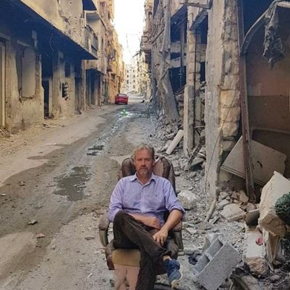
Post Assad's Syria.
Dr in History
Fact Checking
Prof. Royal Military College of Canada
Expert on tech, far-right extremism & terrorism tactics | Ph.D. in International Relations | Author of 'How Terror Evolves' and currently working on 'Uniformed Threats.'
Views = Mine