P2T — Parking to Tree Game 🌳
Turn parking spaces into trees in 60 seconds 🌳 P2T (Parking to Tree) is a tiny browser game inspired by Berlin’s goal to plant 1 million new trees by 2040.
🚗➡️🌳 Berlin wants to plant a million new trees by 2040.
But why wait? Let’s start now.
In P2T (Parking to Tree) you’ve got 60 seconds to turn parking spaces into trees.
Play the tiny game turning asphalt into green friends 💚
🔗 hanshack.com/p2t
07.11.2025 14:03 — 👍 1 🔁 0 💬 0 📌 0
Talks on maps, open data & creative projects:
an embroidery robot stitching maps, a card game, a tool to explore WFS, mapping private pools in Berlin, and parking data for better mobility planning.
👉 Please register here: doo.net/veranstaltun...
09.10.2025 15:57 — 👍 0 🔁 0 💬 0 📌 0
🌍 Maptime Berlin 2025 🌍
The popular Maptime Meetup returns to CityLAB Berlin
📅 When: Wednesday, November 12, 2025, 5:30–9:00 p.m.
📍 Where: CityLAB Berlin, Platz der Luftbrücke 4, 12101 Berlin
09.10.2025 15:57 — 👍 1 🔁 0 💬 1 📌 1
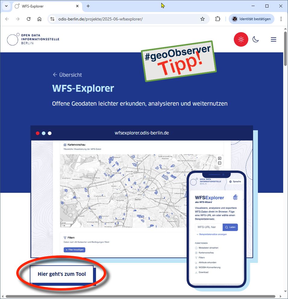
ODIS Berlin: Der WFS-Explorer! / The WFS-Explorer! geoobserver.de/2025/07/22/o... #wfs #webfeatureservice #ogc #gistribe #gischat #fossgis #foss4g #OSGeo #spatial #geospatial #opensource #gis #geo #geoObserver pls RT via @hanshack@troet.cafe
22.07.2025 07:02 — 👍 3 🔁 3 💬 0 📌 0
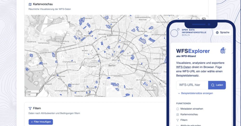
WFS-Explorer
Visualize, analyze and export WFS Data directly in the browser.
➡ Try it now: wfsexplorer.odis-berlin.de
Brought to you by ODIS – The Open Data Information Office Berlin
03.07.2025 08:41 — 👍 0 🔁 0 💬 0 📌 0
🧰 Features:
• Load any WFS via URL or try sample datasets
• Interactive map + attribute table views
• Easy filtering and attribute-based queries
• Export as GeoJSON or CSV
• Automatic conversion to WGS84 (EPSG:4326)
• Share data via link
03.07.2025 08:41 — 👍 1 🔁 0 💬 1 📌 0
WFS-Explorer
Visualize, analyze and export WFS Data directly in the browser.
🌐 New Tool: The WFS Explorer
WFS (Web Feature Services) deliver geodata over the web — but require complex tools and can be a pain to work with.
WFS Explorer is a free, open source, browser-based tool to search, explore, and analyze WFS data — quickly and without the need for expert knowledge.
03.07.2025 08:41 — 👍 2 🔁 1 💬 1 📌 0
People tell me nobody wants to look at climate curves anymore, yet here we are!!! Please enjoy our interactive journey through 485 million years of climate history and dive into the fascinating and important work of paleoclimate scientists.
🎁 www.zeit.de/wissen/umwel...
20.06.2025 09:32 — 👍 112 🔁 37 💬 9 📌 1
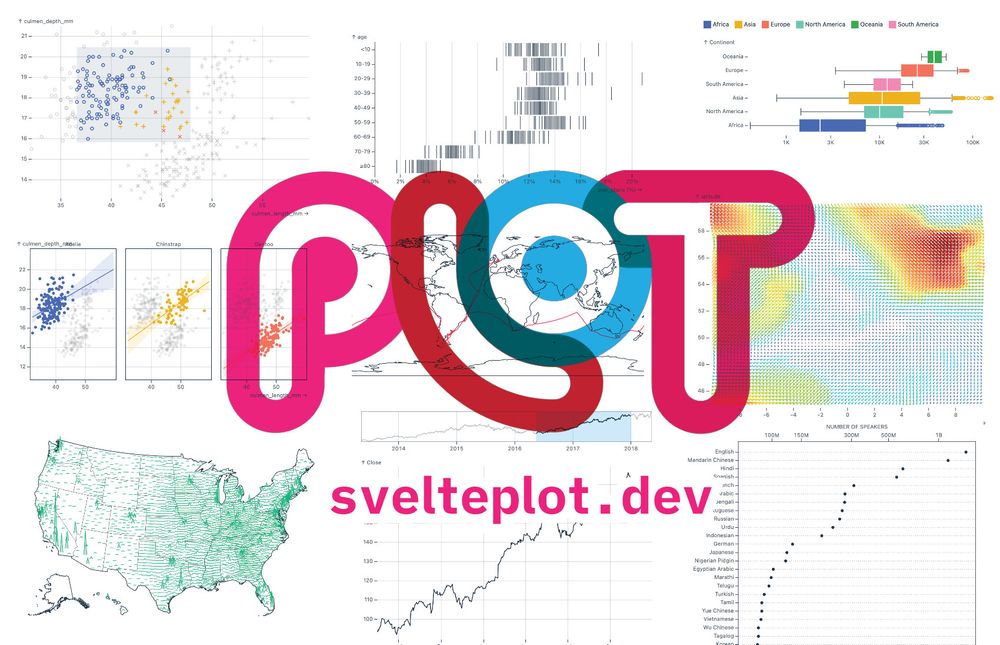
SveltePlot logo with the website address https://svelteplot.dev and a few example plots in the background
Last week I had the pleasure of finally releasing the #SveltePlot alpha version during my talk at the #SvelteSummit in Barcelona. It's a new visualization framework for @svelte.dev that I've been working on for the past 18 months, so it's about time for a 🧵
13.05.2025 11:21 — 👍 167 🔁 36 💬 8 📌 8
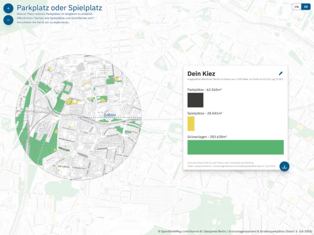
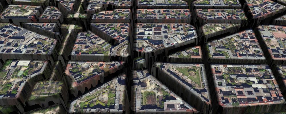
Parking or Playground
This map allows you to compare the size of parking areas, playgrounds, and green spaces in your neighborhood.
How much space do car parks actually take up compared to playgrounds and green spaces? I made a tool that allows you to explore and compare these public spaces in Berlin.
www.hanshack.com/parking/
11.07.2024 06:48 — 👍 2 🔁 0 💬 0 📌 0
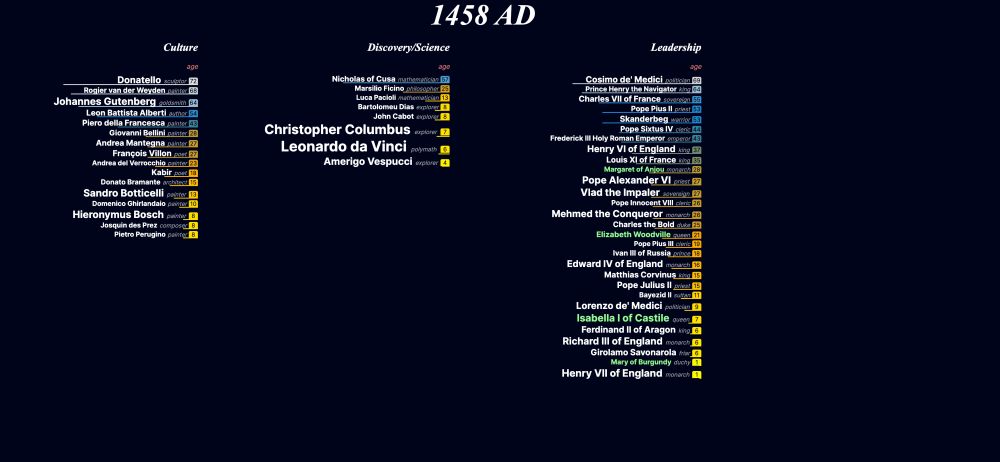
NEW Very quick and small #dataviz experiment: parallel-lives, an interactive timeline of nearly 5000 years of notable people in history. janwillemtulp.github.io/parallel-liv... 3 reasons what I like about this approach:
06.03.2024 09:28 — 👍 22 🔁 7 💬 4 📌 3
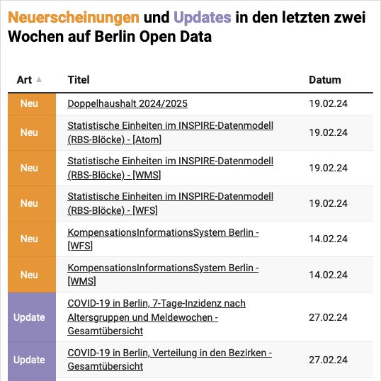
Chart with newest publications and updates on the Berlin Open Data Portal
Keep updated with the newest publications and updates on the Berlin Open Data Portal. The new Chart keeps you informed on a daily basis, as it updates automatically and is easy to embed. odis-berlin.de/projekte/dat...
28.02.2024 08:42 — 👍 1 🔁 0 💬 0 📌 0
🌍 Maptime Berlin is back!
When: Thursday, 29. February from 6 p.m.
Where: CityLAB Berlin, Platz der Luftbrücke 4, 12101 Berlin
Food: 🍕
Register here: citylab-berlin.org/de/events/ma... or on meetup.com
01.02.2024 10:52 — 👍 1 🔁 1 💬 0 📌 0
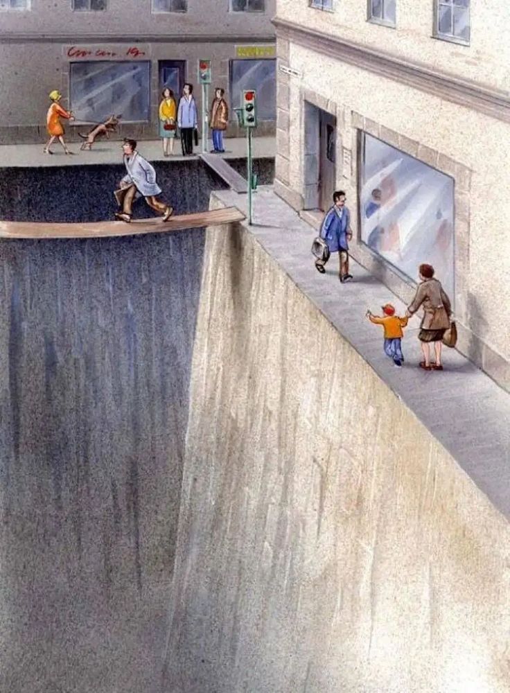
Street Canyons:
A map experiment depicting Berlins streets as canyons, carving through the city's landscape. Inspired by a drawing from Karl Jilg.
hanshack.com/street-canyo...
14.11.2023 08:54 — 👍 7 🔁 1 💬 0 📌 0
Data analyst/scientist making data analysis software, #datavis, #datascience , etc, nature photography, some creativity and hobbyist personal complex medical research . ( Did I miss anything?... well, #mecfs ;)
miskaknapek.eu
Senior Frontend Archeologist @ B2B
🧡 @svelte.dev ambassador
🔗 https://fubits.dev
Information design and data visualisation. Cares about the climate crisis, post-digital media and technological justice. I like code and smoothies.
https://links.jonasparnow.com
📍Berlin
#Maptime is global, decentralized community of local chapters that provide hands-on, beginner-focused workshops for learning about maps and geospatial technology.
my life is derp and i do derp shit
free and easy maps for everyone
Web: https://versatiles.org/
GitHub: https://github.com/versatiles-org
The world in a file. Open source!
more: https://protomaps.com
GitHub: https://github.com/protomaps
posts by @bdon.org
Visualization toolmaker. Founder of Observable. Creator of D3. Former NYT Graphics. Pronounced BOSS-tock.
https://datavandals.com
The Data Vandals present data in exciting new ways, stopping people in their tracks and inviting them to learn more.
Art, writing, walking, typing. . . ✩ˎˊ˗
Book: Figured Stones → https://www.corbelstonepress.com/books/figured-stones
Data Dude, interested in Open Data / Science / History/ Public Transport
https://github.com/alexanderguentert
Wir stärken Zivilgesellschaft, Demokratie und Teilhabe!
🌐 www.okfn.de
We provide services, tools and training to build a world open by design where all knowledge is accessible to everyone.
#TheTechWeWant #OpenDataEditor #OpenDataCommons #SchoolOfData #CKAN
Our digital agency is a boutique development shop for data-driven projects & sustainable web products.
https://www.dot.studio
📊 data journalist at DER SPIEGEL
🚀 developer and trainer at tactile.news
🌳 open data for public good at Code for Bielefeld
Data Journalist @ Zeit Online, before: Frankfurter Allgemeine Zeitung
Alumna 2020 @ City, London University
Berlin based information designer with a passion for research and geospatial narratives | currently exploring satellite literacy
⤷ Geospatial Analyst @news.dw.com
⤷ formerly #dataviz 🛰️ 🌍 @planet.com
⤷ Projects: julianpeschel.info
Data journalist with @spiegel.de
https://www.marcelpauly.de/
Berlin UX/UI designer @digitalservice.bund.de. Born: 353.85 ppm CO₂