Crowdfunder success prepares ocean robotics game for launch
Schools in Argyll and Bute to receive copies of the game
We did it! A successful Crowdfunder will see the development our table-top game Drones & Droids.🤖
As well as being available to anyone to buy after we've honoured our fundraiser commitments, copies of the game will be given to local schools.
www.sams.ac.uk/news/sams-ne...
12.11.2025 12:15 — 👍 0 🔁 1 💬 0 📌 0

Maybe Climate Action Tracker updates could be required reading for all. Complicated information clearly presented. There is hope, see what has been achieved since 2015. A long way to go before a sustainable future is achieved @climateactiontracker.org
climateactiontracker.org/publications...
19.11.2025 05:28 — 👍 4 🔁 0 💬 0 📌 0

Collage of several documents and infographics from the CaSTCo project
We were pleased to have been part of #CaSTCo, helping advance collaborative river monitoring across England and Wales.
As well as the new Impact Report, a companion document offers an ambitious vision for the future: castco.org/roadmap
#RiverRecovery
3/3
04.11.2025 10:13 — 👍 0 🔁 1 💬 0 📌 0
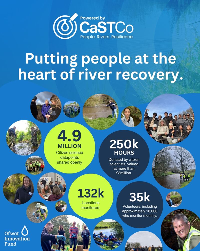
Several photos of people and people sampling in rivers, plus the headline Putting people at the heart of river recovery, and four information points:
4.9 million citizen science datapoints shared openly
250k hours donated by citizen scientists, valued at more than £3million
132k locations monitored
35k volunteers, including approximately 18,000 who monitor monthly
The #CaSTCo project shows how community data can drive decisions on river management in England & Wales.
UKCEH co-led work on data management with Rivers Trust colleagues, developing CaSTCo Data Governance Principles & supporting best practice in citizen science.
🔗 castco.org/impact-report
🧪 1/
04.11.2025 09:57 — 👍 9 🔁 4 💬 1 📌 0

I enjoyed working with the #CaSTCo #citizen-science community to learn about their needs (related to data; from collection to use). One of our outputs, was a set of data governance principles. Read more in impact report. @theriverstrust.bsky.social @ukceh.bsky.social
castco.org/impact-report/
04.11.2025 05:49 — 👍 2 🔁 0 💬 0 📌 0

Impact Report - CastCo
Contents of this report Section 1: Working together CaSTCo’s strength came from the network that surrounded and supported it. Collaboration flourished through shared research, national...
Great to see UK river #citizen-science impact report #CaSTCo published. Telling all about the community's achievements. @ukceh.bsky.social @waterrangers.bsky.social @theriverstrust.bsky.social @riverflies.bsky.social
castco.org/impact-report/
04.11.2025 05:47 — 👍 2 🔁 0 💬 0 📌 0
Learn from Simon about impressive #FDRI efforts to provide quality controlled near-real time data on how our catchments/rivers are responding hydrologically.
29.10.2025 06:09 — 👍 1 🔁 0 💬 0 📌 0

Map of UK with dots indicating river flow stations and colours indicating number of years data available in UK-Flow15
📣 Great news for UK hydrology!
The UK Floods and Droughts Research Infrastructure (FDRI) has announced release of two new datasets: UK-Flow15 and CAMELS-GB v2. They provide access to sub-daily river flow and hydrometeorological data across 100s of UK catchments
🔗 fdri.org.uk/news/new-hyd...
1/ 🧪
23.10.2025 11:20 — 👍 19 🔁 10 💬 1 📌 1
YouTube video by UKCEH
FDRI: Large-sample hydrology data webinar
🎥 Our new webinar introduces UK-Flow15 and CAMELS-GB v2 and shares what’s next for FDRI data.
Watch here 👉 youtu.be/JMZYzlLA_h8
Thanks to all the partners and the community effort making these datasets possible 👏🏼
#FDRI #Hydrology #EnvironmentalScience
23.10.2025 11:20 — 👍 5 🔁 5 💬 1 📌 0

If you're tired of infinite social media scroll, but still want to stay up to date on all things geospatial, tech innovation, & E84, subscribe to our newsletter!
The most recent edition just hit inboxes last week! Check it out & subscribe: mailchi.mp/b55202161651...
15.10.2025 18:42 — 👍 0 🔁 1 💬 0 📌 0
Thanks to these key individuals to helping #FDRI improving knowledge of floods and droughts.
16.10.2025 04:34 — 👍 2 🔁 0 💬 0 📌 0

Palisades resident evacuate the area during the Palisades Fire on 7 January 2025. Credit: Kit Karzen / Alamy Stock Photo
NEW – Global wildfires burned an area of land larger than India in 2024 |
@orladwyer.carbonbrief.org @yaninequiroz.bsky.social @ayeshatandon.carbonbrief.org @giulianaviglione.bsky.social
Read here: buff.ly/AQ99WCO
15.10.2025 23:01 — 👍 30 🔁 20 💬 1 📌 3

Learning about a wide range of meteorological and soil sensor systems from members of the excellent @ukceh.bsky.social #FDRI team.
16.10.2025 04:28 — 👍 2 🔁 0 💬 0 📌 0

An enjoyable day with @ukceh.bsky.social Floods and Droughts Research Infrastructure #FDRI field and digital colleagues exploring data collection on the banks of the River Thames.
16.10.2025 04:26 — 👍 1 🔁 0 💬 0 📌 0
Coming soon on Counting the Earth...
🔥 We discuss the changing nature of wildfires with UKCEH fire scientist Dr Doug Kelley. And we're at Holt Heath in Dorset, scene of a devastating wildfire in August, to talk to Dorset & Wiltshire Fire Service.
🎧🧪 Subscribe on your favourite #podcast provider!
10.10.2025 09:55 — 👍 10 🔁 8 💬 0 📌 0
Is the term "vibe engineering" kind of stupid, leaning into the gatekeeping distinction between "coders" and "real software engineers"
It absolutely is. That's why I think it might stick!
07.10.2025 14:38 — 👍 39 🔁 2 💬 6 📌 0
"We will produce actionable guidance, including a white paper and updated tools, to help repositories, funders, and policymakers strengthen data infrastructure and build resilience against future crises."
07.10.2025 15:17 — 👍 1 🔁 0 💬 0 📌 0

A split image from UN Environment Programme showing a contrast between two scenes:
Left side shows a barren landscape with cracked, dry soil under a dramatic sunset sky with bare tree branches silhouetted against orange and yellow clouds. Text reads "Investing in climate solutions"
Right side shows a vibrant green tree with fresh leaves against a bright blue sky with white clouds, overlooking a lush yellow-flowered meadow. Text reads "Investing in peace"
An equals sign (=) connects the two phrases. The UN Environment Programme logo appears in the top right corner. The image uses stark visual contrast to illustrate the relationship between climate action and peace.
🌍🔥 Climate change fuels insecurity—from resource conflicts to forced migration.
@unep.org explains how climate adaptation & peacebuilding can go hand in hand to build resilience.
Learn more:https://www.unep.org/topics/disasters-and-conflicts/environment-security/climate-change-and-security-risks
07.10.2025 12:09 — 👍 26 🔁 7 💬 1 📌 0
New Lonboard release and new demo! Integrating marimo and Apache DataFusion to visualize the NYC taxi dataset. developmentseed.org/lonboard/lat...
18.09.2025 20:02 — 👍 11 🔁 3 💬 1 📌 0

F3: The Open-Source Data File Format for the Future
SIGMOD 2025
Our SIGMOD paper with our friends at Tsinghua + @wesmckinney.com + @pateljm.bsky.social on creating a next generation open-source data file format is out. F3 is a future-proof file format avoids the mistakes of Parquet.
📄 Paper: db.cs.cmu.edu/papers/2025/...
📁 Code: github.com/future-file-...
01.10.2025 13:49 — 👍 70 🔁 21 💬 4 📌 5

Learning about UK flood hydrology roadmap at #HydroJULES @ukceh.bsky.social Royal Society meeting.
24.09.2025 13:20 — 👍 2 🔁 2 💬 0 📌 0

Panel about "Whose data we can trust?" Great to hear different perspectives on challenges and needs. #CaSTCo river citizen science data.
24.09.2025 10:42 — 👍 0 🔁 0 💬 0 📌 0

Alfie and Josh talking about the challenges of community citizen science data #CaSTCo @odihq.bsky.social
24.09.2025 10:26 — 👍 0 🔁 0 💬 0 📌 0

Lots of sharing citizen science experiences from across the individual river trusts @theriverstrust.bsky.social #CaSTCo
24.09.2025 10:23 — 👍 0 🔁 0 💬 0 📌 0

Fascinating panel about taking #CaSTCo river citizen science data roadmap ahead. Great to the themes in the questions from the audience about funding, lessons learned, trust etc.
24.09.2025 09:44 — 👍 0 🔁 0 💬 0 📌 0

Screengrab from HydroSOS portal with world map on left (shades of red indicate flows lower than normal, blue higher than normal) and on the right a bar chart showing the status of the river Mpanga
The report stresses the cascading impacts of too much or too little water on economies and society.
Future reports will include more data, supported by initiatives like the Global Hydrological Status and Outlook System (HydroSOS), coordinated by UKCEH.
🔗 wmo.int/publication-...
2/ #StateOfWater
19.09.2025 09:28 — 👍 2 🔁 2 💬 1 📌 0
The long-term monitoring addressed in this review is wide-ranging and includes that undertaken by the UK Environmental Change Network. Please take some time to share your views. The closing date is 9am (UK time) on 29th September.
19.09.2025 13:38 — 👍 2 🔁 6 💬 0 📌 1
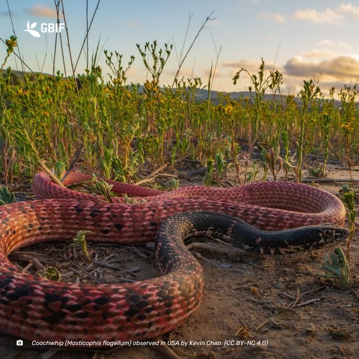
close-up photograph of a brilliant red and black snake in a field
🐍 Scaling up biodiversity data access ✨#VertNet launches a GBIF hosted portal!
Run by a dedicated volunteer network, VertNet plays a vital role in mobilizing biodiversity datasets worldwide. 🌍
🔗 Explore the new portal: gbif.link/VertNet
24.09.2025 07:30 — 👍 2 🔁 1 💬 0 📌 0
Writer. Private investigator. Green transitionist. Northern Californian. joshmorsell.com. @greenintel.bsky.social.
Associate Professor, Bristol University 🧪
Resilience loss ⚖️ Early warning signals ⚠️ multiple stressors 🏭 biodiversity change 🌍 rewilding 🦫
🔗 experimentalconservation.com
Editor at Biology Letters.
Research hydrologist and river photographer. www.riversfromabove.com
The Flood Hub People are flood resilience specialists and the ‘people’ behind The Flood Hub website. Visit The Flood Hub for further flooding advice.
https://thefloodhubpeople.co.uk/
Working to protect UK river water quality, further the understanding of riverfly populations & conserve riverfly species & habitats.
riverflies.org
Hosted by @freshwaterbio.bsky.social
Green Party Leader (England & Wales)
London Assembly Member.
Chair of London's Fire Committee.
🏳️🌈
https://podcasts.apple.com/podcast/id1837201724?i=1000724643828
Co-Creating Ireland's Public Involvement in Open Research Roadmap
ENGAGED is building a national roadmap to shape public involvement in open research in Ireland. We believe that research can and does play an important role in tackling societal challenges.
The UK’s largest collection of UK and international social, economic and population data. Funded by UKRI through the ESRC. https://ukdataservice.ac.uk/
Author: Verified: How to Think Straight, Get Duped Less, and Make Better Decisions about What to Believe Online (University of Chicago Press).
Researcher, infolit/misinfo/rhetoric/civic reasoning. Currently researching AI as tool for critical thinking.
Open, transparent AI for real world impact. Built for developers, creators, and teams shaping what’s next.
Curator, fossil reptiles and amphibians, at Natural History Museum London UK. Honorary positions at UCL and University of Adelaide. #tuatara 🦎 #Cymraeg He/Him
Orcid: 0000-0002-0146-9623
The UK’s largest public funder of research. Our mission is to advance knowledge, improve lives and drive growth.
#FundedByYou
Also autoposting to @news.ukri.org, @funding.ukri.org, @blogs.ukri.org and @events.ukri.org. Topic specific feeds coming soon!
Highly interdisciplinary University of Manchester network of over 2200+ researchers across 30 disciplines and the whole range of digital research.
linktr.ee/UoMDigitalFutures
Snarkmonger. Chief Cloud Economist at The Duckbill Group.
he/him.
Get my opinionated take on AWS news: http://lastweekinaws.com/t/
Signal: 833-AWS-BILL (833-297-2455)
Likes building things. Founder/CPO @electricsql. Founder @ Gatsby
The world in a file. Open source!
more: https://protomaps.com
GitHub: https://github.com/protomaps
posts by @bdon.org
BIDS is a space for Open Scholarship, Open Source, and interdisciplinary collaboration on AI in science and society. It is part of the UC Berkeley College of Computing, Data Science, and Society.
https://bids.berkeley.edu/
Using data, transparency and accountability to stop 🌳deforestation and 🏞️nature loss.
Former BBC journo now communications lead at www.globalcanopy.org
Also on https://www.linkedin.com/in/darrenjamesmckenzie
Staff Engineer, open source fan, hacking on geospatial in my spare time. Lives in London
We are an independent, non-profit research organization forecasting the speed & scale of technology driven disruption