bsky.app/profile/muel...
24.01.2026 18:47 — 👍 828 🔁 427 💬 95 📌 74
YouTube video by wallcloudchaser
April 26, 2024 Minden-Harlan, Iowa, Violent EF3 Tornado - FULL 360 Edit 4K -Real Time/Time Lapse
The April 26, 2024, Minden-Harlan, Iowa, violent, multi-vortex EF3 tornado full 360 video edited w/time lapse & about 25 minutes real-time footage.
Watch the video here:
youtu.be/tJtuxh2q4rU
#tornado #iawx @nws.noaa.gov @spc-storms.nws-bot.us @iowastatepatrol.bsky.social @dmg.weather.im
10.01.2026 07:33 — 👍 1 🔁 0 💬 0 📌 0

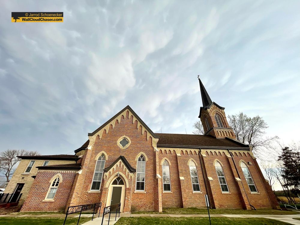
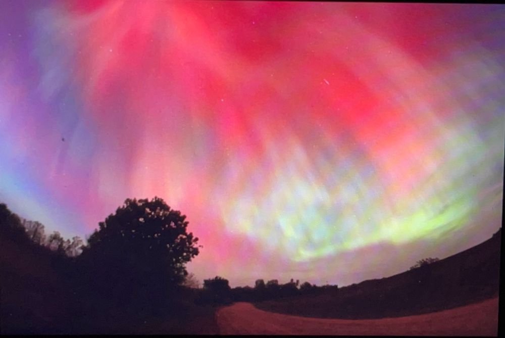
Aurora image behind St. John's Church at Union Hill, Minnesota, on November 11, 2025. Photo by Jarrod Schoenecker/WallCloudChaser.com
Here is one of the 2,000 or so photos I took last night at a handful of locations. This aurora shot was taken at St. John The Evangelist Catholic Church at Union Hill, Minn., on Tuesday, Nov. 11, 2025. #aurora
#aurora #auroraborealis #northernlights #twincitiesaurora #minnesotanorthernlights
13.11.2025 01:03 — 👍 4 🔁 0 💬 0 📌 0
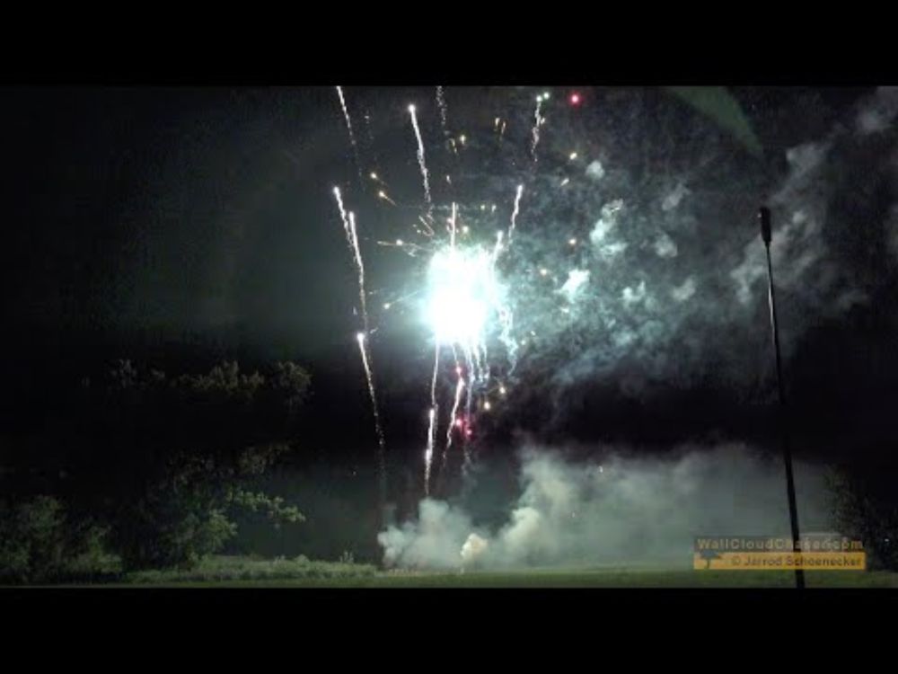
YouTube video by wallcloudchaser
90th Annual Kolacky Days Fireworks ~ Montgomery, Minnesota ~ Saturday, July 27, 2024
Happy 4th of July! Here are your 10 p.m. fireworks from RES Pyro shot at the 90th Annual Kolacky Days in Montgomery, Minn., on July 27, 2024. Enjoy this bug and sweat-free!
youtu.be/kSkORNxmaJM
#kolackydays
05.07.2025 03:03 — 👍 2 🔁 0 💬 0 📌 0
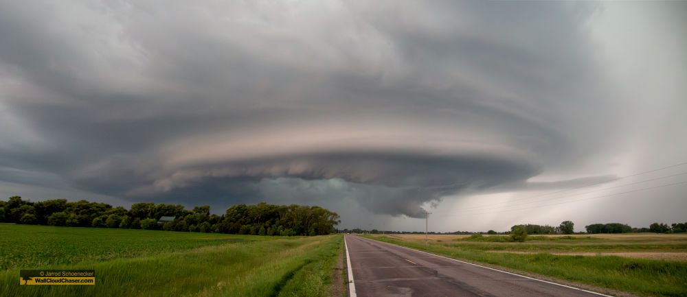
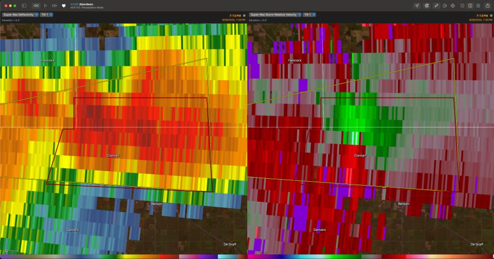
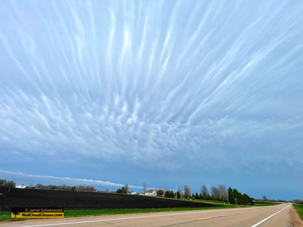
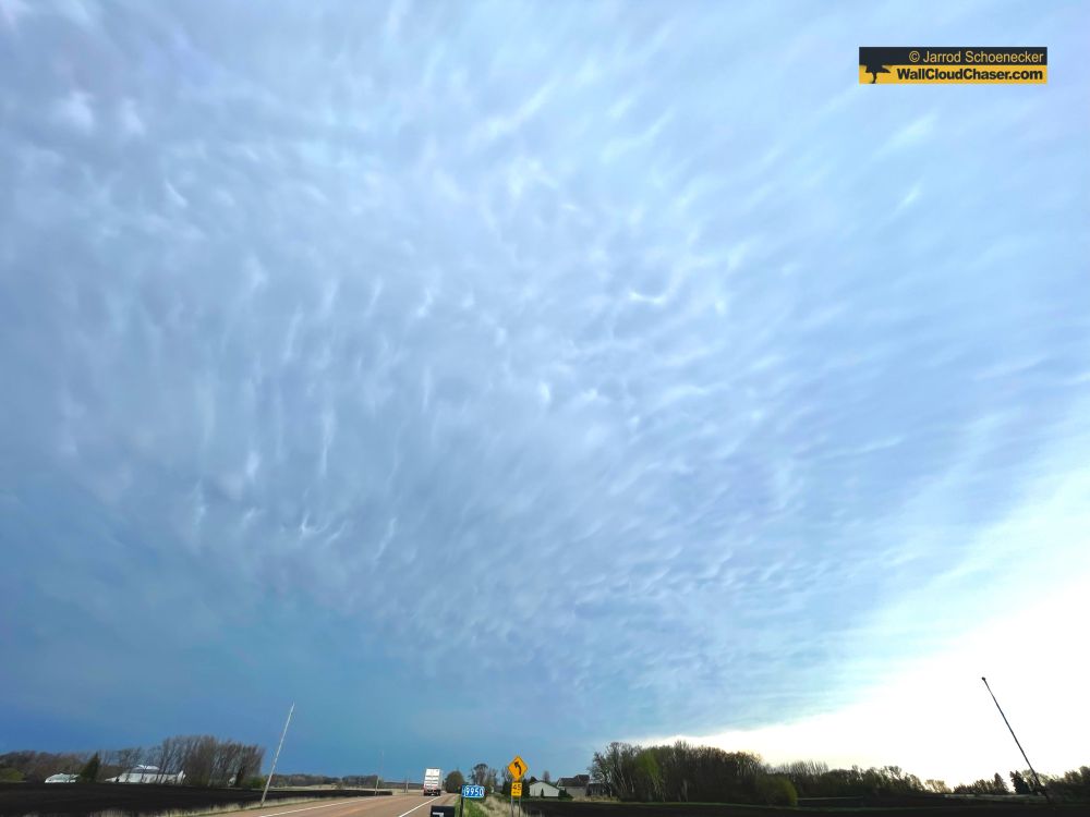
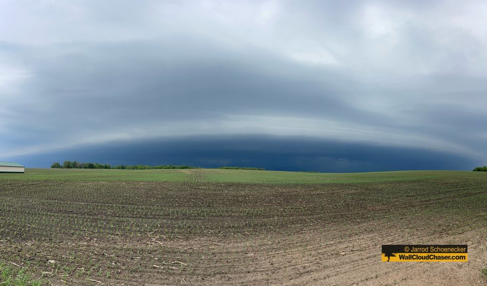
I took a little bit of time to download files from the chase yesterday in west-central Minnesota and edit one pano of this beast storm over the town of Clontarf, Minn., at about 7:15 p.m. on June 28, 2025. Great structure & tried to produce a tornado but couldn't pull it off.
#mnwx #mothership
30.06.2025 03:03 — 👍 2 🔁 0 💬 0 📌 0
YouTube video by StormChasingVideo
Tornado and Wall Cloud near Mankato, MN
Well, after my main camera not recording during the two tornadoes I got today, I give you the handheld shot of the more robust one southeast of Mankato, Minn. But hey, it was one of the most enjoyable chases I've had in a while, so I guess there's that!
#tornado #mnwx
youtu.be/ATqRGofnZgw?...
17.06.2025 06:18 — 👍 1 🔁 1 💬 0 📌 0
East of Norwood Young America now. #mnwx
15.05.2025 12:36 — 👍 1 🔁 0 💬 0 📌 0
WHAT SHOULD BE MY NEXT VIDEO UPLOAD????
Take the poll!
poll-maker.com/poll5482114x...
03.05.2025 06:21 — 👍 1 🔁 0 💬 0 📌 0
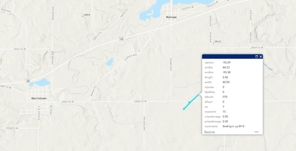
UPDATE TO YESTERDAY's INFO: You can add another EF0 tornado to the list from Rice County just south of Warsaw -- Less than a half mile long. #tornado
01.05.2025 04:35 — 👍 1 🔁 0 💬 0 📌 0
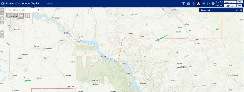
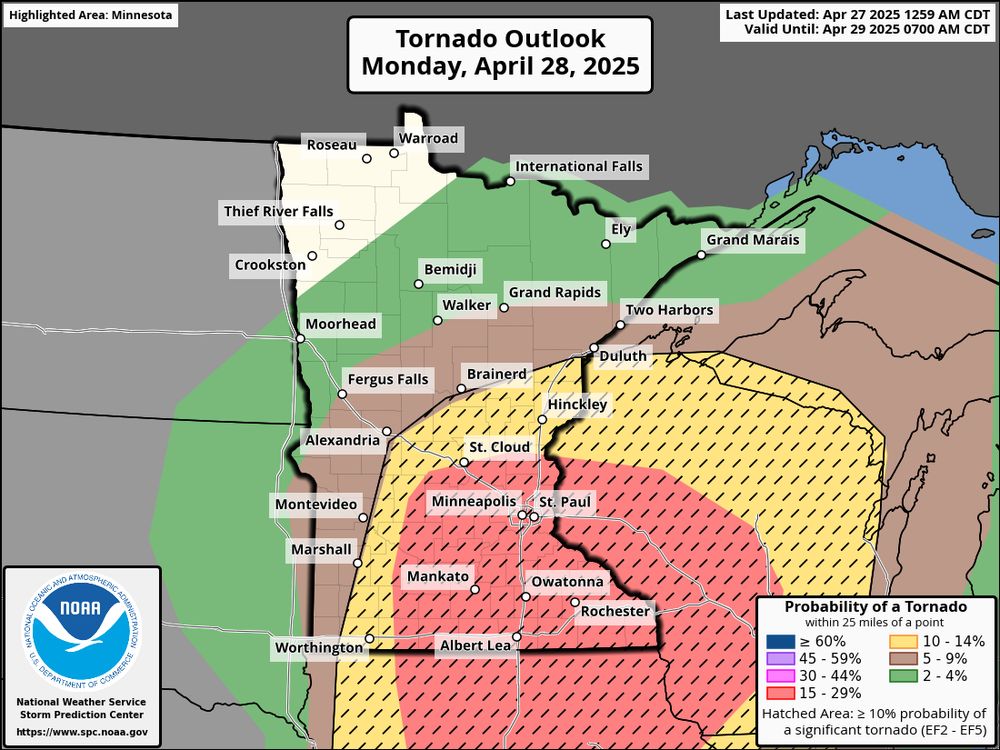
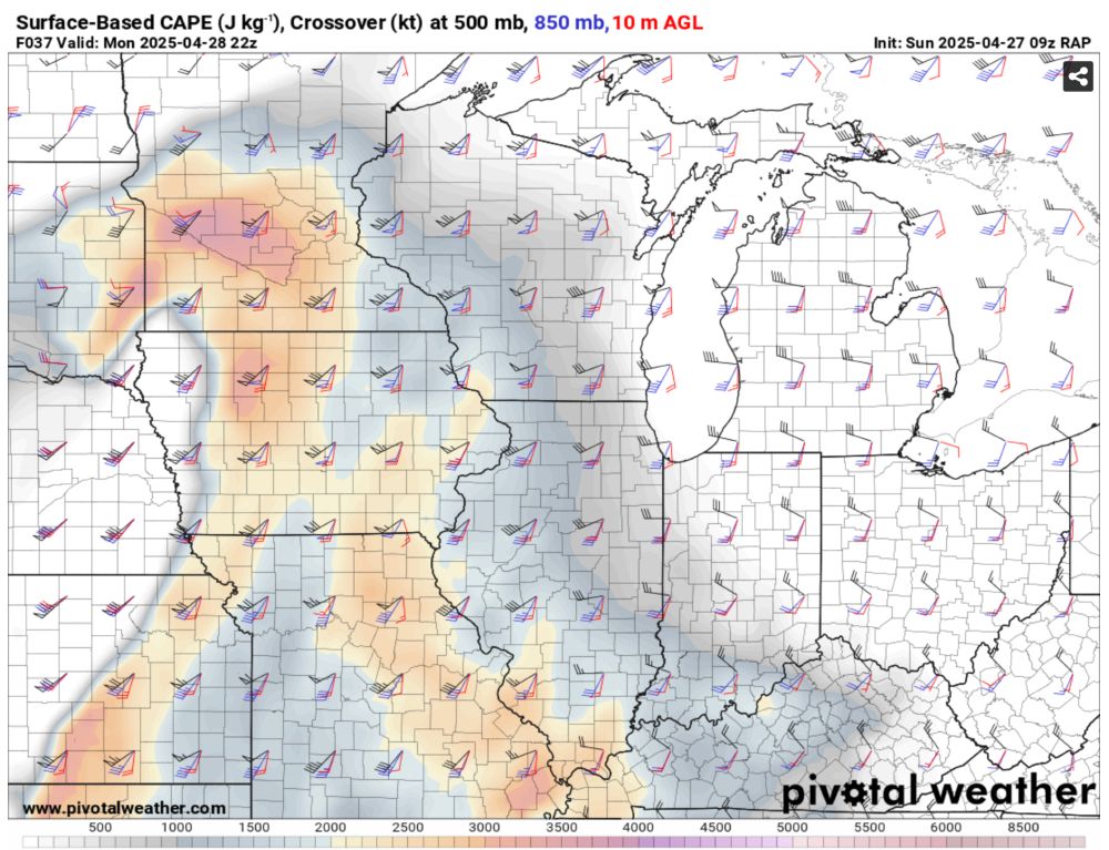
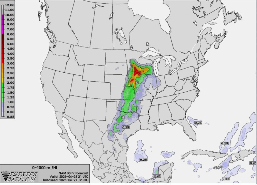
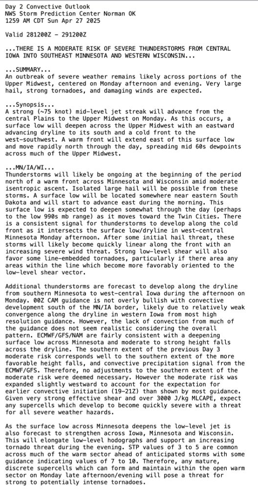
NWS Twin Cities is completing a survey of at least 5 tornadoes from Monday, April 28, 2025.
SE Rice County preliminary EF-1 TOR & 4 other TORs on the fringes of the service area south of Eau Claire.
NWS Green Bay had an addition 2 TORs east of Wausau.
#mnwx #wiwx #tornado @mpx.nws-bot.us
30.04.2025 05:07 — 👍 2 🔁 1 💬 0 📌 0
YouTube video by wallcloudchaser
4K ~ Time Lape of Supercell w/Funnel in Le Sueur & Waseca County, Minn., NO Narration~ July 13, 2024
In case you missed it the other night, I uploaded a narrated time lapse video. Here is that same video but with the music only (no narration). #mnwx
youtu.be/FnwS7mq59qg
27.04.2025 02:16 — 👍 1 🔁 0 💬 0 📌 0
YouTube video by wallcloudchaser
4K ~ Time Lape of Supercell w/Funnel in Le Sueur & Waseca County, Minn., w/Narration ~ July 13, 2024
New late-night video out for all you night owls! I narrated a supercell event from July 13, 2024, in Le Sueur & Waseca Counties. It's a good typical chase that I felt really shows what it's like being out there in southern Minnesota's common setups. Enjoy!
#mnwx #supercell
youtu.be/IFwLaa39tq8
24.04.2025 05:36 — 👍 1 🔁 0 💬 0 📌 0
YouTube video by wallcloudchaser
4K ~ Funnel-Like Wall Cloud Near St. Peter, Minn., ~ April 17, 2025
Here's the first action of the season here in southern Minnesota. A wall cloud, a funnel-like wall cloud, time-lapse, and a tiny bit of flooding from west and north of St. Peter. #mnwx. youtu.be/z02WAZD339w
17.04.2025 23:43 — 👍 1 🔁 0 💬 0 📌 0
Auroras near Waterville, Minnesota, taken by Jarrod Schoenecker.
I figured I should make my first post here. This is a cell phone shot of auroras I took near Waterville, Minn., from Oct. 10, 2024. #aurora #northernlights #mnwx
12.11.2024 01:19 — 👍 4 🔁 2 💬 0 📌 0
Advancing the understanding of Earth system variability and addressing the risks. Home of #CESM
Protecting, defending public interest journalism in the 21st century.
Subscribe to our ne🦋sletters: https://freedom.press/newsletters/
Staff, board members: https://bsky.app/starter-pack/freedom.press/3lbkk5aha5l22
More: linktr.ee/freedomofpress
The ONLY Storm Photography Contest on the planet run by storm chasers.
https://www.stormphotocontest.com
Chapter of the American Meteorological Society @ametsoc.org at the University of Colorado Boulder 🦬
Researching and reporting the science and impacts of climate change 🌎
climatecentral.org
Meteorologist in Duluth, MN with a passion for big ideas. Opinions expressed here do not represent my employer.
In-Situ Collaborative Experiment for the Collection of Hail In the Plains (ICECHIP). NSF funded field campaign to better understand all aspects of hail. https://icechip.niu.edu/
Meteorologist | Ph.D., M.S., and B.S. at OU | Maryland born and raised | Dog and cat mom | Forever raging at the patriarchy | Opinions = mine | she/her
Automated bot posting tornado warnings from NWS across the US. Not an official account of NWS. @asteroiddave.bsky.social is my father.
BLACK = RADAR INDICATED
ORANGE = SPOTTER / RADAR CONFIRMED
RED = PDS (Dangerous Tornado)
PURPLE = TORNADO EMERGENCY
Dad, husband, President, citizen. barackobama.com
NOAA delivers critical science, service and stewardship to Americans. Stop cuts at NOAA!
Leading independent expert in weather and climate.
Atmospheric Scientist, Ph.D., CCM. Chased by storms since 1981. Trail running, mountain biking, skiing. Astro, weather, and landscape photographer.
dblanchard.net/blog/
UIUC Class of ‘24 | Purdue graduate student (WRRL) | atmospheric science and severe weather 🌩️⚡️🌩️
Storm Spotter - Kansas City Native - https://reportbuddy.org/
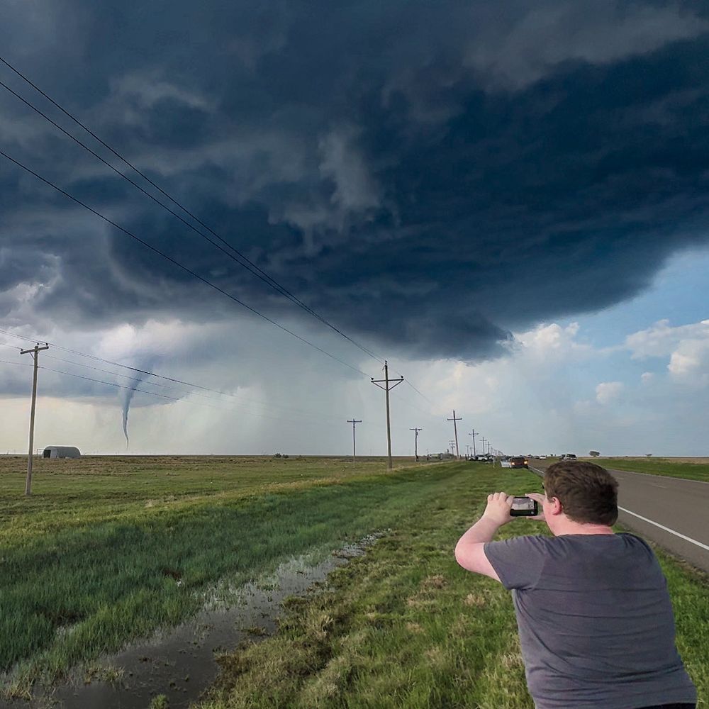
Storm Chaser (10 🌪️) | Documentary Filmmaker 🎥 | Opinions Are My Own | Content Creator 📲 21 Years Old | Occasional Tornado Wrangler-Driver-Intoer | USAF 🇺🇸
Iowa State Meteorology ‘26 | storm chaser | severe weather researcher | Cincinnati ➡️ Ames |🌪️ = 17? | 🌌 = 4 |
Dryline Enthusiast, Norman OK
23 | Storm Chaser | Photographer | Videographer | Spinny Cloud Enthusiast |Future Subaru driver | Business/Media Contact: tristanwhitewx@gmail.com