Walterville, east of Springfield this morning. About a half inch at 500'
📸: Michael Guidero
#oregon #orwx #snOMG

@holdenlecroy.bsky.social
Weather + Outdoors. #SCnative turned #Oregonian. KEZI-9 Chief Meteorologist. Christian, hiker, runner, likes coffee, talks science.
Walterville, east of Springfield this morning. About a half inch at 500'
📸: Michael Guidero
#oregon #orwx #snOMG

❄️This is why there are delays for some schools and offices, some areas have a good dusting while others not. Think of how hilly Douglas County is, some neighbors have a good bit. #ORwx #Oregon
05.02.2025 16:54 — 👍 6 🔁 0 💬 1 📌 0
Update in Corvallis, from Pete Varga
05.02.2025 16:45 — 👍 1 🔁 0 💬 0 📌 0
West hills of Junction City this morning. 1-2 inches.
📸: Cora Height
#Oregon #ORwx

❄️Good dusting in Corvallis right now and still coming down in waves through the morning! #ORwx #Oregon
05.02.2025 16:37 — 👍 3 🔁 0 💬 1 📌 0
Coast Range Mountains has finally gotten a good bit of snow with this storm, 1-2 inches so far with more on the way today.
⚠️Use caution on all roads headed to the Coast.
📸: Marlee Bossman
#Oregon #ORwx #snOMG
possible dusting to half-inch! up to an inch in higher hills
05.02.2025 00:23 — 👍 1 🔁 0 💬 1 📌 0
Now that's snow! Parts of the Klamath Basin has seen over 15" of snow! #ORwx
📸: @BasinTheo on Twitter


❄️⚡️WILLAMETTE VALLEY & OREGON COAST: Things could get interesting tonight... we're expecting the development of a convective line of snow showers... this same area of low pressure moving in has had a history of producing snow in Western WA. Could see a good dusting to 1" #ORwx #Oregon #Portland
04.02.2025 23:42 — 👍 6 🔁 0 💬 0 📌 1Foothills (including Oakridge and Mckenzie) additional 1-inch.
Valley (including Eugene, Portland and Roseburg) Dusting to half-inch. #ORwx

❄️🌲More snow in Oakridge today- this is coming in from the S. Oregon stalled front. We are expecting more snow for the foothills tonight/tomorrow, possibly up to an additional 1-inch!
📸: Molly Stone
#Oregon #ORwx #snOMG

❄️Winter wonderland in Phoenix, Oregon and about 2 more inches of snow on the way today!
📸: Katie Myers Andrews
#oregon #snOMG #ORwx

❄️Fat flakes flying in Medford... again 😂 Easily gonna pick up another 2" today. This is gonna go down as top 10 snowstorms for Southern Oregon with some valley locations reporting as much as 15 inches. #ORwx #snOMG #Oregon
04.02.2025 21:17 — 👍 7 🔁 1 💬 0 📌 0
❄️Snowing good in... **checks notes**... Lincoln City 😳 this morning! This is apart of a separate upper atmosphere low pressure to the north that is producing "convective, scattered snow bands" #ORwx #snOMG
04.02.2025 17:33 — 👍 14 🔁 1 💬 1 📌 2
❄️Back edge of snow is winding down for Southern Oregon and we are expecting a bit of a break for pretty much everyone on Tuesday. Except Klamath Falls and Siskiyou County.
Wednesday, Thursday will bring the chance of scattered snow for Willamette (LIGHT ACCUM.) #ORwx #Oregon
damn low elevation 😔
03.02.2025 22:38 — 👍 1 🔁 0 💬 0 📌 0

⛔️❄️INTERSTATE 5: No surprise here- major backups on I-5 SOUTH IN ASLAND, NORTH IN YREKA. I would expect a full closure soon, snow is falling to heavy at Siskiyou Pass to keep up. AVOID. #ORwx #CAwx
03.02.2025 22:38 — 👍 8 🔁 0 💬 0 📌 0
12:45 PM UPDATE- Now about 3 inches on the ground near downtown Medford
03.02.2025 20:46 — 👍 1 🔁 0 💬 0 📌 0
SOUTHERN OREGON SNOW
❄️⚠️Medford Schools, Central Point early dismissal starts at 11:30 AM... About 2 inches in Medford, 4 inches in Ashland and upwards of 12" in Klamath Falls. Snow will continue until 11PM tonight for Medford, 8PM Tuesday for Klamath. #ORwx #Oregon #snOMG


❄️Snow has not let up, will not let up for #KlamathFalls until Wednesday (NOW 10-inches)... meanwhile atmospheric river has finally pivoted back northwest providing snow for Medford area through 11PM tonight. #ORwx #snOMG
03.02.2025 17:29 — 👍 5 🔁 0 💬 0 📌 0Morning snow levels drop to about 300 FEET each day, up to 700 FEET in the afternoon for Willamette Valley on Wednesday/Thursday.
03.02.2025 07:28 — 👍 1 🔁 0 💬 0 📌 0


Showery, wet snow not adding up to anything for the Willamette Valley until possibly Wednesday morning, Thursday morning.
❄️Southern Oregon will continue to get slammed with a COLD atmospheric river producing an additional 20 inches for some THRU THURSDAY. #ORwx #snOMG
definitely not- this is more of a snow variety, if any!
01.02.2025 00:32 — 👍 1 🔁 0 💬 0 📌 0


🌧️Rain arrives Thursday night, next break towards Saturday.
❄️Second storm is Sunday night and into Tuesday morning. A much colder storm, dropping snow levels to the valley floor, but NO MAJOR ACCUMULATIONS EXPECTED. #ORwx #Oregon

❄️Valley snow chances are good next week, but amounts are not good.
Very dry, upper low will swing through and precipitation will be VERY scattered. Things could change, but we NEED MORE moisture. Dusting possible each and every morning next week and that's about it. #ORwx #Oregon

🌪️Multiple waterspouts over and around Kauai this morning, vertical profile indicates some incredibly cold air, slight shear with height capable of producing multiple supercells here in the past hour. Same storm will bring snow to Mauna Kea and Mauna Loa Friday. #Hawaii
30.01.2025 17:49 — 👍 3 🔁 0 💬 0 📌 0For water and snowpack data at least... month data tends to fluctuate from year to year and lacks reliable data here in the Northwest. Water years are rainy season focused and combines what we need for a season. What happens in the season is more important than the month.
30.01.2025 07:09 — 👍 1 🔁 0 💬 0 📌 0for the water year! I don't mess with that month to month stuff because it gets messy and inaccurate... October 1-now is what matters!
30.01.2025 06:44 — 👍 1 🔁 0 💬 1 📌 0
After, it'll pull down some incredibly cold air, a new low next week and we could be talking about a dusting of snow on the valley floor each MORNING with rain in the AFTERNOON starting Sunday night...
#snOMG #Oregon
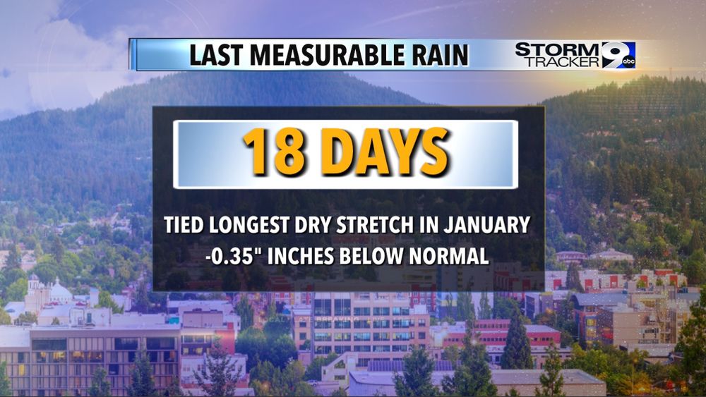


Last bit of sunshine until... well not sure yet. Thing is we turn one of our driest stretches in January ever (18 DAYS) into a significantly wet pattern starting Thursday night.
Storm is strengthening, tapping into moisture set to bring an Atmospheric River FIRST... #ORwx