Dramatic push of ice cover on Lake Erie due to strong NW winds last night into this morning. MODIS satellite imagery today (Feb 7) vs 3 days ago (Feb 4)
07.02.2026 17:38 — 👍 1 🔁 0 💬 0 📌 0
@robsobs.bsky.social
Retired Environment Canada meteorologist. Niagara region, Canada
Dramatic push of ice cover on Lake Erie due to strong NW winds last night into this morning. MODIS satellite imagery today (Feb 7) vs 3 days ago (Feb 4)
07.02.2026 17:38 — 👍 1 🔁 0 💬 0 📌 0
A record high of 18.0C in Calgary AB today, beats previous record for Feb 5th of 17.4C in 1984. It’s the earliest in the year they’ve ever hit 18.0C or more (previous earliest date was Feb 12 1934) and ranks as Calgary’s 8th warmest February day on record (data since 1885)
06.02.2026 00:58 — 👍 2 🔁 0 💬 0 📌 0True.. the meteorological version of "If it bleeds, it leads.."
05.02.2026 21:30 — 👍 1 🔁 0 💬 0 📌 0
A fine looking early February day in southern AB. Already 15C as of 10:40 am with beautiful blue skies, and a gusty southwest wind. Heading up to a record 20C this afternoon.
05.02.2026 18:03 — 👍 2 🔁 0 💬 1 📌 0It never ceases to amaze me that people will remember the one or two times the groundhog or Farmers Almanac was right and swear by them every year, but they'll remember the few times meteorologists were wrong and they'll never believe them. Mets need to hire the PR director from Punxsutawney Phil
05.02.2026 14:41 — 👍 9 🔁 3 💬 0 📌 2
Canadian snowbirds don't have to head to Florida for warmth this winter.. head to southern Alberta instead! Temperatures expected to hit the 20C mark today in south AB while Florida struggles in the low to mid teens this aftn. A good example of the warm west/cold east pattern we've been having
05.02.2026 14:30 — 👍 2 🔁 0 💬 0 📌 0Data from Alberta AGCM network. Official ECCC sites in bold
05.02.2026 01:30 — 👍 0 🔁 0 💬 0 📌 0

Incredibly mild early February day in southern AB. Several sites hit the 20C mark, including Lethbridge with a record high of 20.6C, 2nd warmest Feb temp on record there (21.8C on Feb 27 1992) Hot spot was Hays at 21.3C. Calgary tied a daily record high for Feb 4th at 16.2C (tied with 1992)
05.02.2026 01:29 — 👍 2 🔁 0 💬 1 📌 0
All time hottest September temperature for Canada set today at Ashcroft BC with a sizzling 40.8C. Beats previous record of 40.0C set in Morden MB (Sep 1906), Lost River SK (Sep 1940) and Lytton BC (Sep 2025) (TWN graphic)
04.09.2025 02:23 — 👍 2 🔁 0 💬 0 📌 0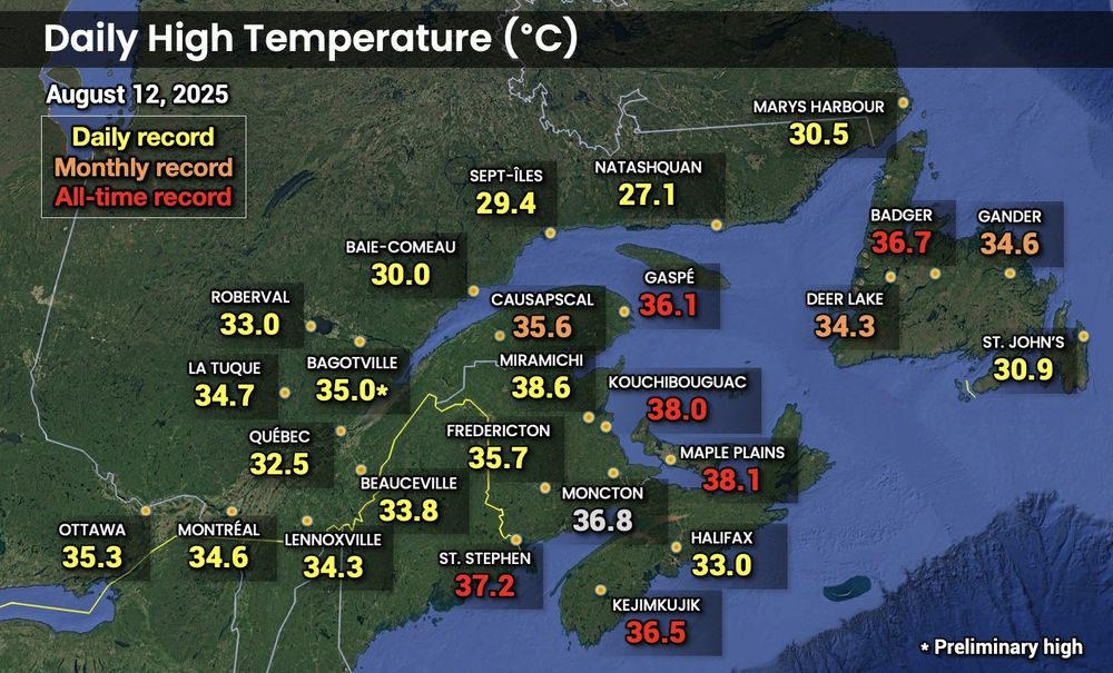
Even hotter than yesterday in Eastern Canada!
All-time records were set at several stations, and the all-time PEI record was shattered with 38.1° at Maple Plains!
36.7° in Badger, NL tied August record for NL and all-time record for the island. 38.6° in Miramichi is 0.8° below NB all-time record. ♨️

How are we doing for the first half of July in terms of temperature? Top 5 to Top 10 coolest in parts of Texas, but much warmer than normal across much of the northern tier.
16.07.2025 13:32 — 👍 45 🔁 9 💬 4 📌 0

Areas of heavier rainfall across Niagara over past 24 hours brought 25-50 mm over localized areas. Otherwise only 5-10 mm between heavier bands with less than 5 mm west of Grimsby.
01.07.2025 11:28 — 👍 0 🔁 0 💬 0 📌 0
One lone band of cumulus clouds over Niagara nicely marks convergent zone between Lake Erie and Lake Ontario lake breezes this afternoon
28.06.2025 20:06 — 👍 1 🔁 0 💬 0 📌 0
CoCoRaHS report from Morriston ON, east of Cambridge.. 90 mm of rain last night in less than 90 minutes
28.06.2025 12:15 — 👍 0 🔁 0 💬 0 📌 0

Quite the soaker through the Cambridge area last night.. upwards of 75-100 mm of rain reported, much of it falling between 10 pm and 1 am.
28.06.2025 11:45 — 👍 0 🔁 0 💬 1 📌 0
Area of showers over Lake Ontario will clip north St Catharines into NOTL over the next hour. Heads up if your boating in this area for some gusty showers moving in.
26.06.2025 16:43 — 👍 1 🔁 0 💬 0 📌 0

Quite the soaker across parts of Niagara this morning. Heavier cells early this morning gave 30-50 mm of rain through the Niagara Falls-Chippawa area in just over an hour. (Radar image from 530 am)
26.06.2025 11:41 — 👍 0 🔁 0 💬 0 📌 0Max temps across Niagara today (Jun 24):
Vineland: 35.6C
Grimsby: 35.5C
St Catharines: 35.4C
Beamsville: 35C
Niagara Falls: 33.9C
Welland: 33.1C
Port Colborne: 29C
These are the hottest temperatures recorded in Niagara since July 2020.

Just popped another degree...likely the final one for the day. Boston reaches a June record of 102F. #wbz
24.06.2025 21:44 — 👍 67 🔁 17 💬 5 📌 3

33-36C temps over much of Niagara this afternoon.. except 28C near Lake Erie. Last day of the really hot stuff before less oppressive conditions Wednesday
24.06.2025 19:29 — 👍 0 🔁 0 💬 0 📌 0Peak humidex values this afternoon will range from 38C near Lake Erie to 45C over north Niagara
24.06.2025 11:40 — 👍 0 🔁 0 💬 0 📌 0
One more day of oppressive heat and humidity over Niagara today with highs of 35C over north Niagara to 28C near Lake Erie. A slight chance of showers or thunderstorms later today into tonight then not as hot Wednesday
24.06.2025 11:21 — 👍 1 🔁 0 💬 1 📌 0One more day of oppressive heat and humidity over Niagara Tuesday with highs of 32C over south Niagara to 35C north. A chance of showers or thunderstorms Tue pm/night then not as hot Wednesday
23.06.2025 22:50 — 👍 0 🔁 0 💬 0 📌 0Max temps across Niagara today (Jun 23) through 5 pm:
Grimsby: 36.0C
Vineland: 35.2C
St Catharines: 34.5C
Niagara Falls: 33.3C
Welland: 32.4C
Port Colborne: 28C
A maximum of 36.0C at Toronto Pearson airport as of 5 pm. This is the 2nd hottest June temperature on record for Toronto, surpassed only by 36.7C on Jun 30 1964. The 36.0C is the hottest day in Toronto since at least Jul 13 2016 (also 36.0)
23.06.2025 21:13 — 👍 0 🔁 0 💬 0 📌 02 pm temps across Niagara (Jun 23):
- Grimsby: 35C (unofficial)
- Vineland: 34.3C
- St Catharines: 33.8C
- Niagara Falls: 33.3C
- Welland: 31.9C
- Port Colborne: 28C
Humidex values ranging from 40-44. Official 2 pm hot spot in Ontario is Toronto Pearson at 34.8C.


St Catharines already up to 29C as of 9 am. Likely hitting a record high 35C this afternoon. Recall that two days ago Env Canada was forecasting a *high* of only 27C for St Catharines for today. Faulty forecast algorithm leading to poor temperature forecasts in Niagara.
23.06.2025 13:43 — 👍 1 🔁 0 💬 0 📌 0Today’s hot spots in Ontario via official ECCC network:
- Delhi: 35.3C
- Hamilton RBG: 35.3C
- Toronto Pearson 34.8C
Both Delhi and Hamilton RBG set new record highs for the date (Jun 22). Toronto Pearson was just short of today’s record high of 35.5C in 2022.
Maximum temperatures across Niagara today (Jun 22) as of 5 pm:
Grimsby: 35.5C
Beamsville: 35C
Vineland: 33.9C
St Catharines: 33.6C
Queenston: 33C
Niagara Falls: 32.8C
Welland: 31.4C
Port Colborne: 28C

Lake Erie lake breeze has pushed up into northern Niagara as of 2 pm marked by edge of CU field. That has stabilized temperatures in the 27-30C range over south Niagara while 32-35C heat continues over north Niagara
22.06.2025 18:34 — 👍 1 🔁 0 💬 0 📌 0