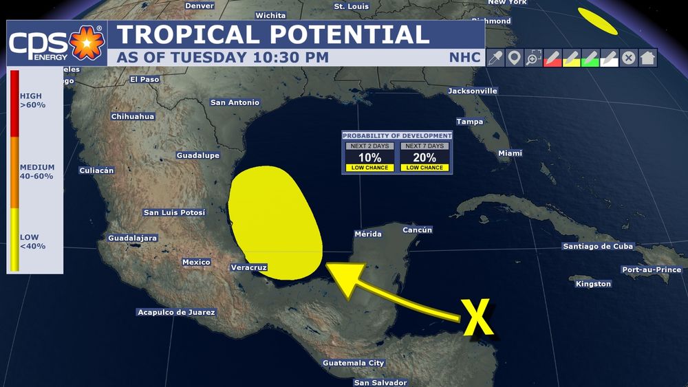
THE TROPICS: National Hurricane Center has flagged a disturbance that once gets into the SW Gulf has a low potential for tropical development. Models suggest this disturbance could bring increased moisture to S. TX. and could enhance rain chances starting Friday into Saturday.
13.08.2025 03:14 — 👍 1 🔁 0 💬 0 📌 0
4:07PM: A strong thunderstorm near Bulverde is moving southwest at 10 mph. Expect moderate to heavy rain, lightning, wind gusts up to 50 mph, and even half inch size hail is possible.
12.08.2025 21:11 — 👍 2 🔁 0 💬 0 📌 0
TROPICAL WAVE: Satellite shows a tropical wave near Nicaragua. Long range models show this could bring moisture to South Texas this Friday. This could enhance rain & storm chances a bit. High pressure would help move this in our direction. Tropical development is low as this is a mid level feature.
12.08.2025 19:48 — 👍 2 🔁 0 💬 0 📌 0
LATER THIS WEEK: In my previous post I mentioned no threat to the Gulf with Tropical Storm Erin. Here is why. High pressure will set up east of us. This will act as a shield to protect us. It is expected to stay over the Atlantic but East Coast residents will need to monitor for any shift in track.
11.08.2025 16:02 — 👍 2 🔁 0 💬 0 📌 0
TRACKING ERIN: Tropical Storm Erin has formed in the Atlantic with sustained winds of 45 mph. It is expected to strengthen into a hurricane (1st one of the season) and possibly major hurricane. Models suggest this staying in the Atlantic. At this time no threat to Gulf.
11.08.2025 15:07 — 👍 2 🔁 0 💬 0 📌 0
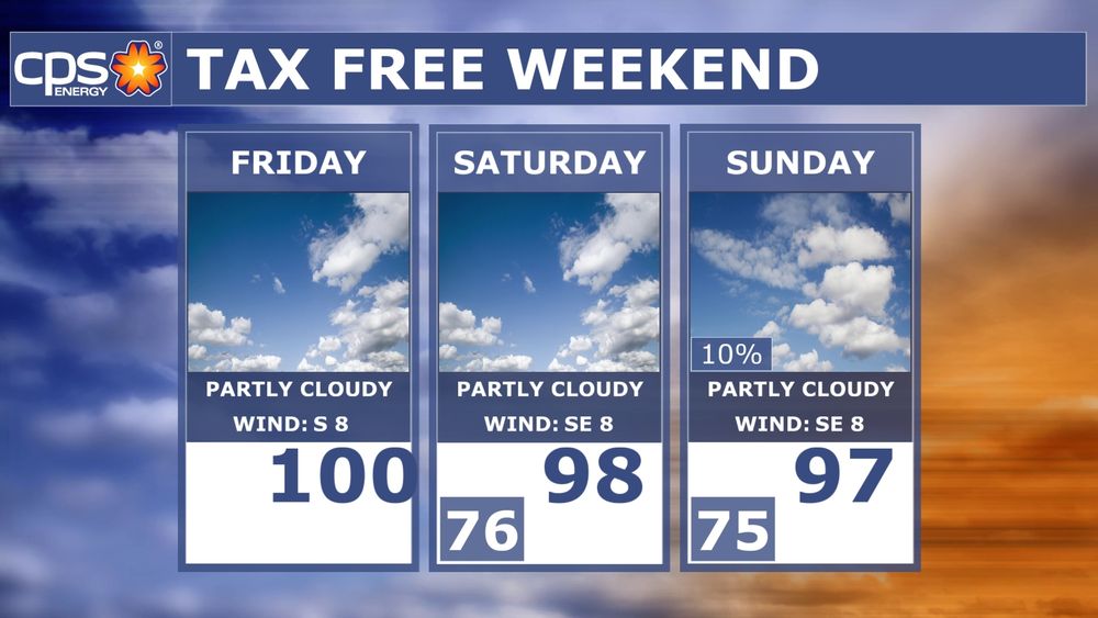
TAX FREE WEEKEND: If you're hitting the stores starting today, stay hydrated. High temperatures expected to be in the triple digits. Heat Index values will be around 104° this afternoon. Temps ease off a bit with an extremely small rain chance on Sunday.
08.08.2025 13:20 — 👍 2 🔁 0 💬 0 📌 0
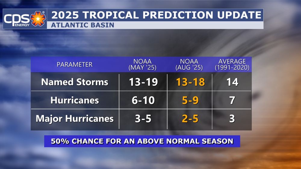
TROPICAL UPDATE: NOAA released an update to their tropical forecast this morning. Not much has changed. They are still expecting an above normal season. Looking out a few weeks, it looks like tropical activity will continue to increase. Too early to say if Texas or the Gulf will be affected.
07.08.2025 16:51 — 👍 2 🔁 0 💬 0 📌 0
WILDFIRE: A wildfire is currently ongoing in Southern Bexar county. It's occuring in the 2200 Blk. of Silver Mountain. Texas Forest Service is saying about 400 acres have burned and it is currently 50% contained.
06.08.2025 01:57 — 👍 2 🔁 0 💬 0 📌 0
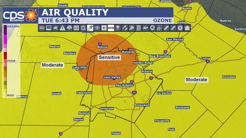
AIR QUALITY: Ozone has reached the "Unhealthy for Sensitive Groups" level. If you have any breathing issues, you'll want to limit your time outdoors the next couple of hours.
05.08.2025 23:45 — 👍 2 🔁 0 💬 0 📌 0
11:14AM: Isolated showers have made it into Bexar county. The stronger storms will remain east of San Antonio. There are a few more showers and storms in North Texas that are moving south. If they hold together, they could make it to our area later this afternoon.
04.08.2025 16:17 — 👍 3 🔁 0 💬 0 📌 0
9:07AM: There is a storm complex in Central Texas moving south. The stronger storms will stay east of San Antonio. An isolated chance for showers and storms is possible in the next 2 hours in SA. Models suggest another round is possible later this afternoon for our area.
04.08.2025 14:09 — 👍 3 🔁 1 💬 0 📌 0
DEXTER: Not talking about the show but we have newly formed Tropical Storm Dexter in the Atlantic. This storm will continue to move away from the United States as we move into this week.
04.08.2025 03:00 — 👍 1 🔁 0 💬 0 📌 0
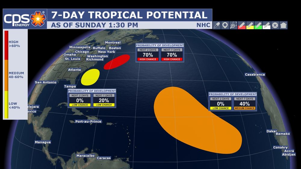
THINGS ARE HEATING UP IN THE TROPICS: Nat'l Hurricane Ctr. has flagged 3 areas for tropical development over the next 7 days. At this time, neither one poses a risk to Texas or the Gulf but we are heading into the heart of tropical season, so it time to start paying attention to the tropics.
03.08.2025 18:48 — 👍 2 🔁 0 💬 0 📌 0
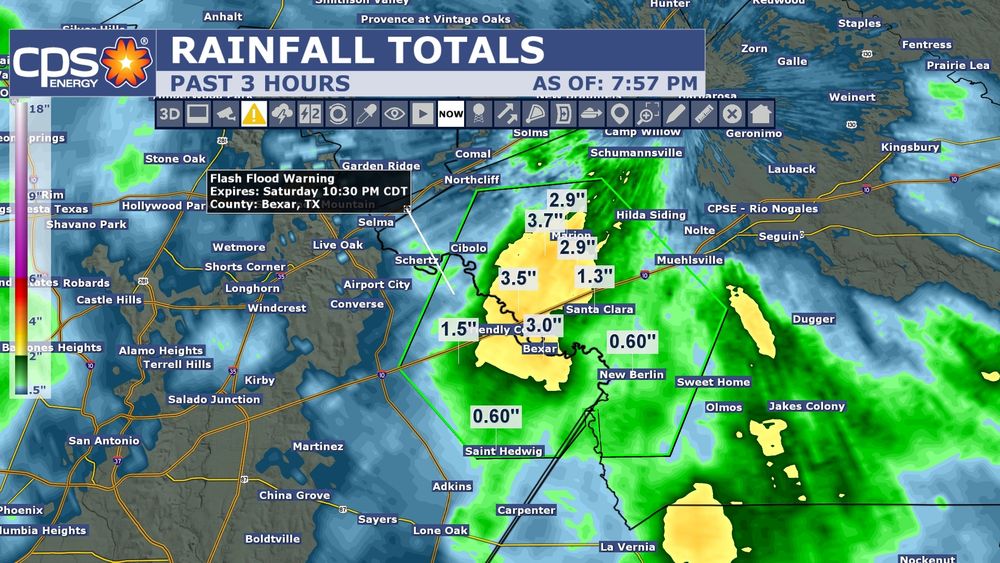
8:PM: Flash Flood Warning for eastern Bexar county until 10:30pm. Rainfall estimates of 2-4" has fallen in the warned area. Up to an additional one inch is possible.
03.08.2025 01:12 — 👍 1 🔁 0 💬 0 📌 0
Yes pretty much any areas within 1604.
02.08.2025 23:35 — 👍 0 🔁 0 💬 0 📌 0
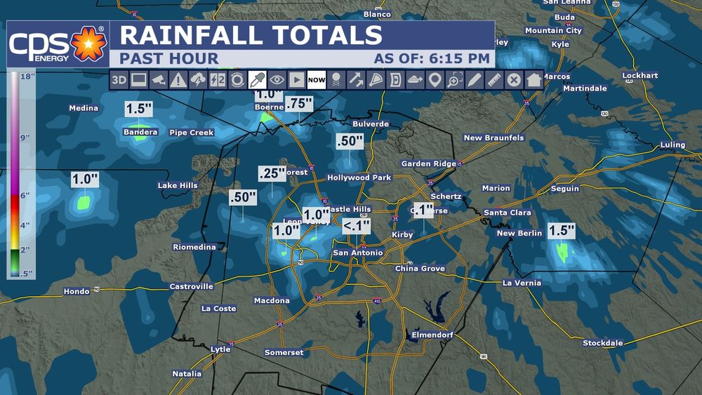
1 HOUR TOTALS: Parts of San Antonio have seen up to 1 inch of rain in the past hour. More rain is still falling. Watch out around low water crossings.
02.08.2025 23:19 — 👍 4 🔁 1 💬 1 📌 0
6PM: Scattered showers and storms have made it to Bexar county. Locally heavy downpours are likely. Storms do contain lightning. Small hail also possible.
02.08.2025 23:02 — 👍 3 🔁 0 💬 1 📌 0
WE HAVE TCs FOLKS…TCs: I’m not talking about Taco Cabana either. Towering Cumulus are going up north of San Antonio in the Hill Country. Showers and storms are beginning to develop. These storms will eventually move closer to the SA area later this afternoon.
02.08.2025 18:08 — 👍 2 🔁 0 💬 0 📌 0
DON'T WASH THAT CAR TODAY: Mother Nature may actually give you a free one. There is a weak cold front that is expected to spark off some showers and storms this afternoon. Expect moderate to heavy rain, lightning, some isolated flooding, gusty winds and small hail can't ruled out.
02.08.2025 13:52 — 👍 1 🔁 1 💬 1 📌 0
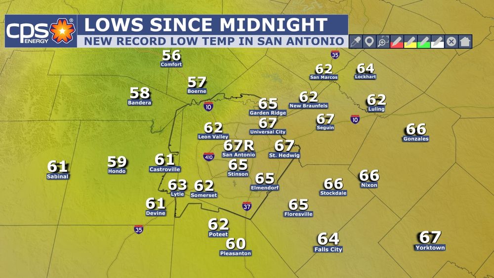
NEW RECORD LOW: It's not often we say that especially in the summertime. With the lower humidity, this helped to drop temps into the 60s this morning. San Antonio's low temp of 67° broke the old record of 68° set back in 1949. Humidity goes back up late tonight.
30.07.2025 19:14 — 👍 2 🔁 0 💬 0 📌 0
TSUNAMI WARNING: has been issued for parts of the west coast in northern California. Tsunami Advisory goes up and down the west coast. This is in response to a 8.8 earthquake near Russia. Tsunami waves have been observed in Russia and recently in Sand Island, Midway Island.
30.07.2025 04:31 — 👍 2 🔁 0 💬 0 📌 0
TSUNAMI WARNING: for the State of Hawaii. Alert stating a tsunami has been generated that could cause damage along the coastlines of all islands of Hawaii. Urgent action should be taken to protect lives and property.
30.07.2025 01:02 — 👍 1 🔁 0 💬 0 📌 0
12:33PM: Good afternoon! I'm already tracking showers and storms about to move into Bexar county. These storms are not severe but will contain lightning, moderate to heavy rain, gusty winds up to 40 mph, and very small hail (low end chance of that).
27.07.2025 17:37 — 👍 2 🔁 0 💬 0 📌 0
2:25PM: Scattered showers are moving across South Texas this afternoon. Isolated showers moving into San Antonio at this time. This will be the trend the rest of the afternoon, hit and miss showers/storms. Locally heavy rain is possible with any stronger shower or storm. Severe weather not expected.
26.07.2025 19:28 — 👍 2 🔁 0 💬 0 📌 0
8:19PM: Scattered showers and storms have developed and moved into San Antonio. Expect moderate to heavy rain, lightning, small hail, and wind gusts 40-50 mph
16.07.2025 01:23 — 👍 1 🔁 0 💬 0 📌 0
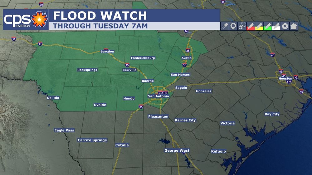
NEW FLOOD WATCH: NWS has issued a Flood Watch for Bexar county until Tuesday 7am. A few storms will have the capability of producing locally heavy rainfall that could lead to isolated flash flooding.
14.07.2025 20:03 — 👍 1 🔁 0 💬 0 📌 0
FLOOD WATCH EXTENDED: NWS has extended the Flood Watch until Monday 9am. It was originally set to expire at 7pm. More showers and storms are developing southwest of San Antonio. Some of this activity could move north toward San Antonio later tonight.
13.07.2025 23:44 — 👍 1 🔁 0 💬 0 📌 0
LATER TODAY: We could still see isolated to scattered storms this afternoon and evening. Don't focus on the location of rain/storms. They could be anywhere in the San Antonio area. As I keep mentioning stay weather aware. The green area represents the Marginal Risk for wind gusts up to 60 mph.
13.07.2025 17:47 — 👍 1 🔁 0 💬 0 📌 0
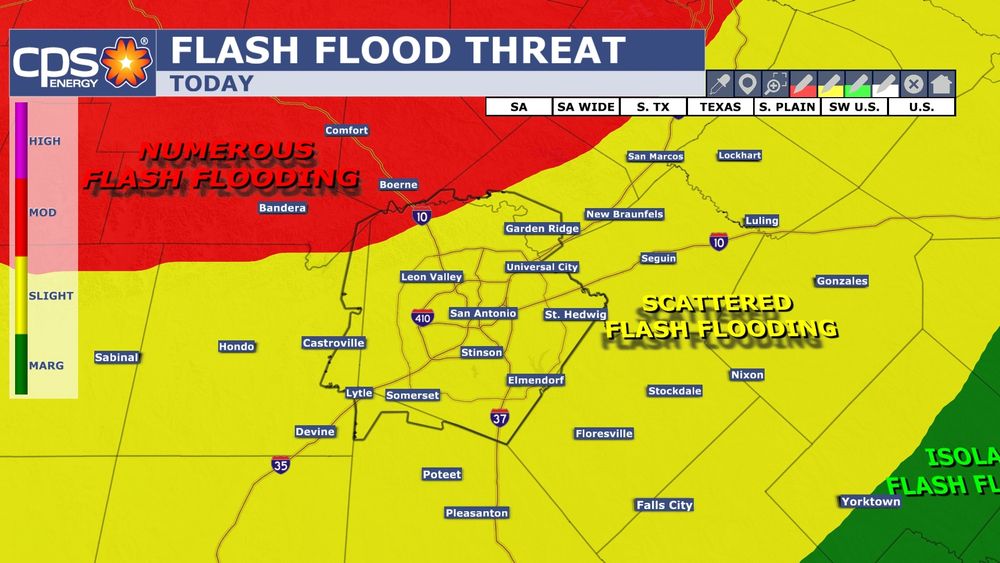
FLOOD THREAT: As we move through the afternoon hours, flash flooding will still be possible. The Weather Prediction Center has nudged the Moderate Risk for flash flooding into northwestern parts of Bexar county. Stay weather aware today especially if you live in low lying areas.
13.07.2025 17:23 — 👍 1 🔁 0 💬 0 📌 0
HERE COMES THE RAIN AGAIN: First off good song by the Eurythmics. Expect moderate to heavy rainfall that could lead to flash flooding as these storms move into San Antonio. Lightning and wind gusts up to 50 mph possible. Not expecting hail.
13.07.2025 15:42 — 👍 1 🔁 0 💬 0 📌 0
I love weather! CBS Duluth, MN May 23, 1976-80, KGNS Laredo, TX Feb 14, 1980-now. NCEI/NWS coop site 415060 June 10, 1985 to December 31, 2023. NWS Jefferson Award. AMS CBM#18
Breaking News 🚨 on Bluesky from reliable sources. All by a reporter and family therapist
Threads: 121k followers (same user). Formerly newsbreaking on X
Donate: https://buymeacoffee.com/newsbreakinglive
Husband, Father, Florida State grad, and then Meteorologist by day...gym rat by night.
Talking up a storm! ⛈️ 30 | TX | San Antonio | @KENS5
Spectrum News Meteorologist
UNC CHARLOTTE Alum
Rays and Panthers Fan
Meteorologist at KEYC-TV
MSState Alumna 🐾
Certified Meteorologist at FOX4 in Kansas City (CBM #851) 🌩️ • #KCwx #MOwx #KSwx • 📨 Email: Jacob.Lanier@fox4kc.com
⛈️ ABC News Meteorologist, Weather & Climate Producer
🎓 Kean University Alum
⚾️ Mets fan
https://abcnews.go.com/
CEO of Bluesky, steward of AT Protocol.
Let’s build a federated republic, starting with this server. 🌱 🪴 🌳
I’m the weekday morning and noon meteorologist at ABC7 New York.
TV Engagement Coordinator + Weather at Covering Climate Now | Award-winning Meteorologist | #NCState Alum | Drone Photography
Colorado State Atmospheric Science Ph.D. '19 | Texas A&M Meteorology '13 | Studies concurrent, collocated tornado and flash flood events | San Antonio Spurs Fan
Breaking news and developing stories from the U.S. and around the world
Editor in Chief, MeidasNews. Former Fed & State Prosecutor, Marine, Attorney. Switched parties from R to D in 2020. MeidasPlus.com/subscribe
Weather + Outdoors. #SCnative turned #Oregonian. KEZI-9 Chief Meteorologist. Christian, hiker, runner, likes coffee, talks science.
Chief Meteorologist at KCCI in Des Moines, IA
@NCState | Meteorologist/Stormwater for @RaleighGov and Freelance for @WRAL| Founder of North Carolina’s Weather Authority with over 650k followers on FB|
https://t.co/rmPgbwdgpH
Founder of Triad weather HQ on Facebook with 14K+ followers|weather in the Triad of NC| Storm spotter|
Found of Find Your Tornado Shelter and map maker. Also works on consulting and products for local and national media outlets within the realm. Graduated with my Ph.D. from Mississippi State in 2023. God has got me this far...what's next?
Meteorologist: WMC Action News 5, #Memphis 〽️| Formerly: WABG, WNCT, WECT, WLBT |🏳️🌈. Opinions, views = mine. RP ≠ Endorsement. #mswx #tnwx #arwx #mowx