With children already loaded onto planes, a federal judge on Sunday temporarily blocked the Trump administration from deporting dozens of Guatemalan minors and demanded assurances that they would remain in shelters until a more permanent ruling. nyti.ms/4oSpm2q
01.09.2025 09:25 — 👍 248 🔁 69 💬 29 📌 6

A Lagos community, destroyed in one day
At least 9,000 people have been forcefully evicted from a riverside community in Nigeria's most populous city, Lagos. Like many waterfront communities across the city, it has faced multiple threats an...
At least 9,000 people have been forcefully evicted from a riverside community in Nigeria's most populous city, Lagos. Like many waterfront communities across the city, it has faced multiple threats and been targeted by luxury real estate developers.
07.03.2025 22:53 — 👍 605 🔁 203 💬 33 📌 13
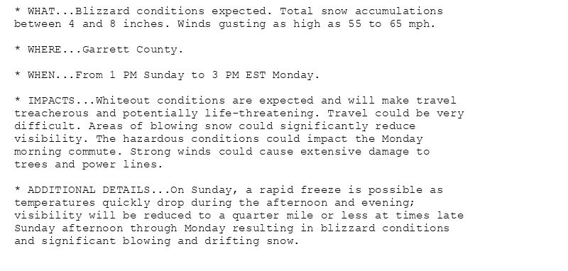
* WHAT...Blizzard conditions expected. Total snow accumulations
between 4 and 8 inches. Winds gusting as high as 55 to 65 mph.
* WHERE...Garrett County.
* WHEN...From 1 PM Sunday to 3 PM EST Monday.
* IMPACTS...Whiteout conditions are expected and will make travel
treacherous and potentially life-threatening. Travel could be very
difficult. Areas of blowing snow could significantly reduce
visibility. The hazardous conditions could impact the Monday
morning commute. Strong winds could cause extensive damage to
trees and power lines.
* ADDITIONAL DETAILS...On Sunday, a rapid freeze is possible as
temperatures quickly drop during the afternoon and evening;
visibility will be reduced to a quarter mile or less at times late
Sunday afternoon through Monday resulting in blizzard conditions
and significant blowing and drifting snow.
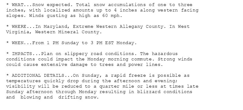
* WHAT...Snow expected. Total snow accumulations of one to three
inches, with localized amounts up to 4 inches along western facing
slopes. Winds gusting as high as 60 mph.
* WHERE...In Maryland, Extreme Western Allegany County. In West
Virginia, Western Mineral County.
* WHEN...From 1 PM Sunday to 3 PM EST Monday.
* IMPACTS...Plan on slippery road conditions. The hazardous
conditions could impact the Monday morning commute. Strong winds
could cause extensive damage to trees and power lines.
* ADDITIONAL DETAILS...On Sunday, a rapid freeze is possible as
temperatures quickly drop during the afternoon and evening;
visibility will be reduced to a quarter mile or less at times late
Sunday afternoon through Monday resulting in blizzard conditions
and blowing and drifting snow.
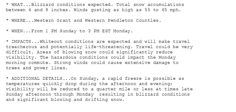
* WHAT...Blizzard conditions expected. Total snow accumulations
between 4 and 8 inches. Winds gusting as high as 55 to 65 mph.
* WHERE...Western Grant and Western Pendleton Counties.
* WHEN...From 1 PM Sunday to 3 PM EST Monday.
* IMPACTS...Whiteout conditions are expected and will make travel
treacherous and potentially life-threatening. Travel could be very
difficult. Areas of blowing snow could significantly reduce
visibility. The hazardous conditions could impact the Monday
morning commute. Strong winds could cause extensive damage to
trees and power lines.
* ADDITIONAL DETAILS...On Sunday, a rapid freeze is possible as
temperatures quickly drop during the afternoon and evening;
visibility will be reduced to a quarter mile or less at times late
Sunday afternoon through Monday resulting in blizzard conditions
and significant blowing and drifting snow.
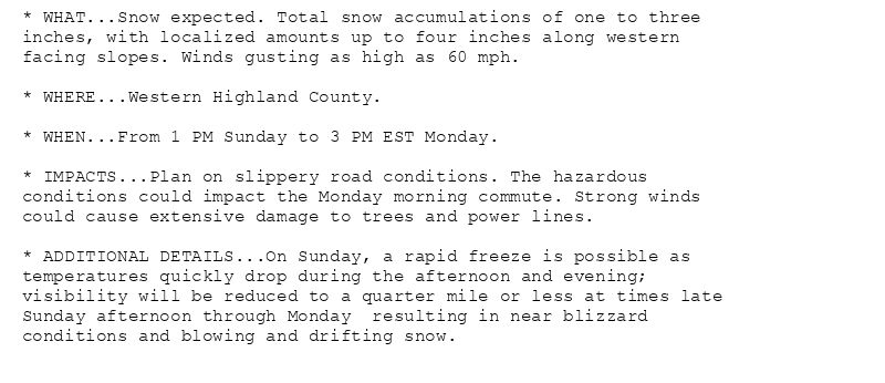
* WHAT...Snow expected. Total snow accumulations of one to three
inches, with localized amounts up to four inches along western
facing slopes. Winds gusting as high as 60 mph.
* WHERE...Western Highland County.
* WHEN...From 1 PM Sunday to 3 PM EST Monday.
* IMPACTS...Plan on slippery road conditions. The hazardous
conditions could impact the Monday morning commute. Strong winds
could cause extensive damage to trees and power lines.
* ADDITIONAL DETAILS...On Sunday, a rapid freeze is possible as
temperatures quickly drop during the afternoon and evening;
visibility will be reduced to a quarter mile or less at times late
Sunday afternoon through Monday resulting in near blizzard
conditions and blowing and drifting snow.
🚨🚨🚨 Blizzard Warning issued February 15 at 6:58PM EST until February 17 at 3:00PM EST by NWS Baltimore MD/Washington DC 🚨🚨🚨
Additional Details Here.(1/2)
16.02.2025 00:01 — 👍 1 🔁 1 💬 0 📌 1
LWX updates Wind Advisory (extends time and expands area to include District of Columbia [DC] and Anne Arundel, Carroll, Cecil, Central and Southeast Howard, Central and Southeast ... at Thu, 13 Feb 2025 20:48:47 +0000 via IEMbot
Additional Details Here.
13.02.2025 21:06 — 👍 0 🔁 1 💬 0 📌 0
That cold foam commercial didn't have to do all that...
10.02.2025 00:54 — 👍 0 🔁 0 💬 0 📌 0
LWX cancels Winter Weather Advisory for St. Marys [MD] and King George [VA]
at Thu, 06 Feb 2025 08:02:46 +0000 via IEMbot
Additional Details Here.
06.02.2025 08:06 — 👍 0 🔁 1 💬 0 📌 0
LWX continues Ice Storm Warning for Western Highland [VA] and Western Pendleton [WV] till Feb 6, 7:00 AM EST
at Thu, 06 Feb 2025 08:02:46 +0000 via IEMbot
Additional Details Here.
06.02.2025 08:06 — 👍 0 🔁 1 💬 0 📌 0
Okay I guess I'm fighting the Ushers then? "NOTHING'S GUNNA BRING ME DOWNNNN"
24.11.2024 01:46 — 👍 5 🔁 0 💬 1 📌 0