Excited I could chat with some of the StoryMaps team about, well, stories and maps. You can read some of the conversation here: ow.ly/cL1n50WzKHG
07.08.2025 23:56 — 👍 3 🔁 0 💬 0 📌 0
@aaronkoelker.bsky.social
I'm here for the maps. Map projects: https://aaronkoelker.com/
Excited I could chat with some of the StoryMaps team about, well, stories and maps. You can read some of the conversation here: ow.ly/cL1n50WzKHG
07.08.2025 23:56 — 👍 3 🔁 0 💬 0 📌 0Perhaps it can just be an amusing distraction from all the physical exhaustion, then
22.04.2025 00:48 — 👍 0 🔁 0 💬 0 📌 0Thanks! It was actually harder than expected to find those kinds of things, and I ended up putting my own list together based on various articles, interviews, documentaries, etc. Hopefully they're actually meaningful to runners!
21.04.2025 16:35 — 👍 0 🔁 0 💬 0 📌 0Shockingly, nobody took me up on running the #BostonMarathon with this thing strapped to their wrist
21.04.2025 14:10 — 👍 87 🔁 8 💬 5 📌 0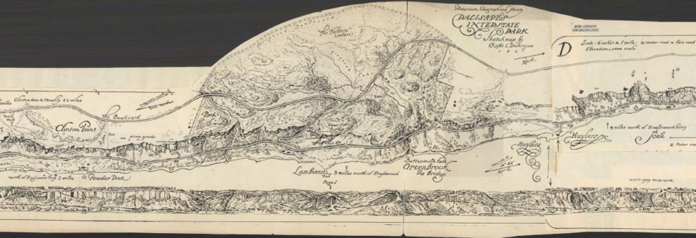
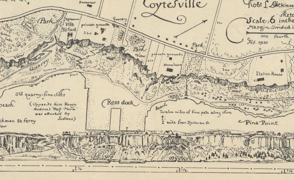
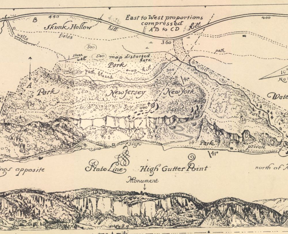
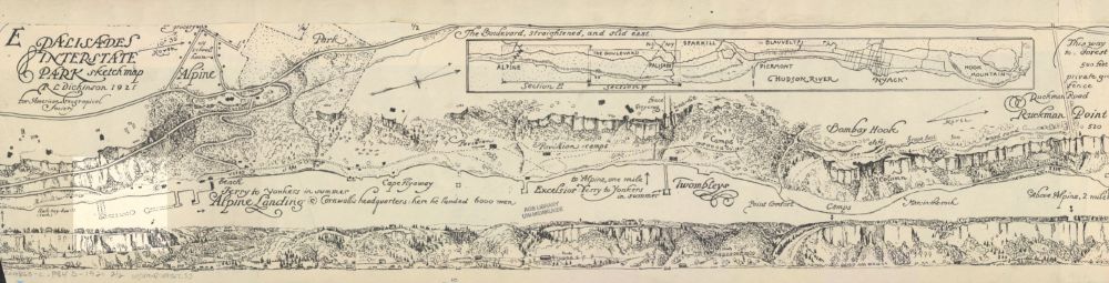
Close-up of Palisades Interstate Park sketch map by Robert. L. Dickinson
Close-up of Palisades Interstate Park sketch map by Robert. L. Dickinson
Close-up of Palisades Interstate Park sketch map by Robert. L. Dickinson
Close-up of Palisades Interstate Park sketch map by Robert. L. Dickinson
Currently obsessing over this 12 ft wide, 1921 strip #map of Palisades Interstate Park in NJ/NY. An amazingly detailed birds-eye view paired with a profile sketch of the park's cliffs, as seen from the Hudson River. collections.lib.uwm.edu/digital/coll...
08.04.2025 21:35 — 👍 12 🔁 1 💬 0 📌 0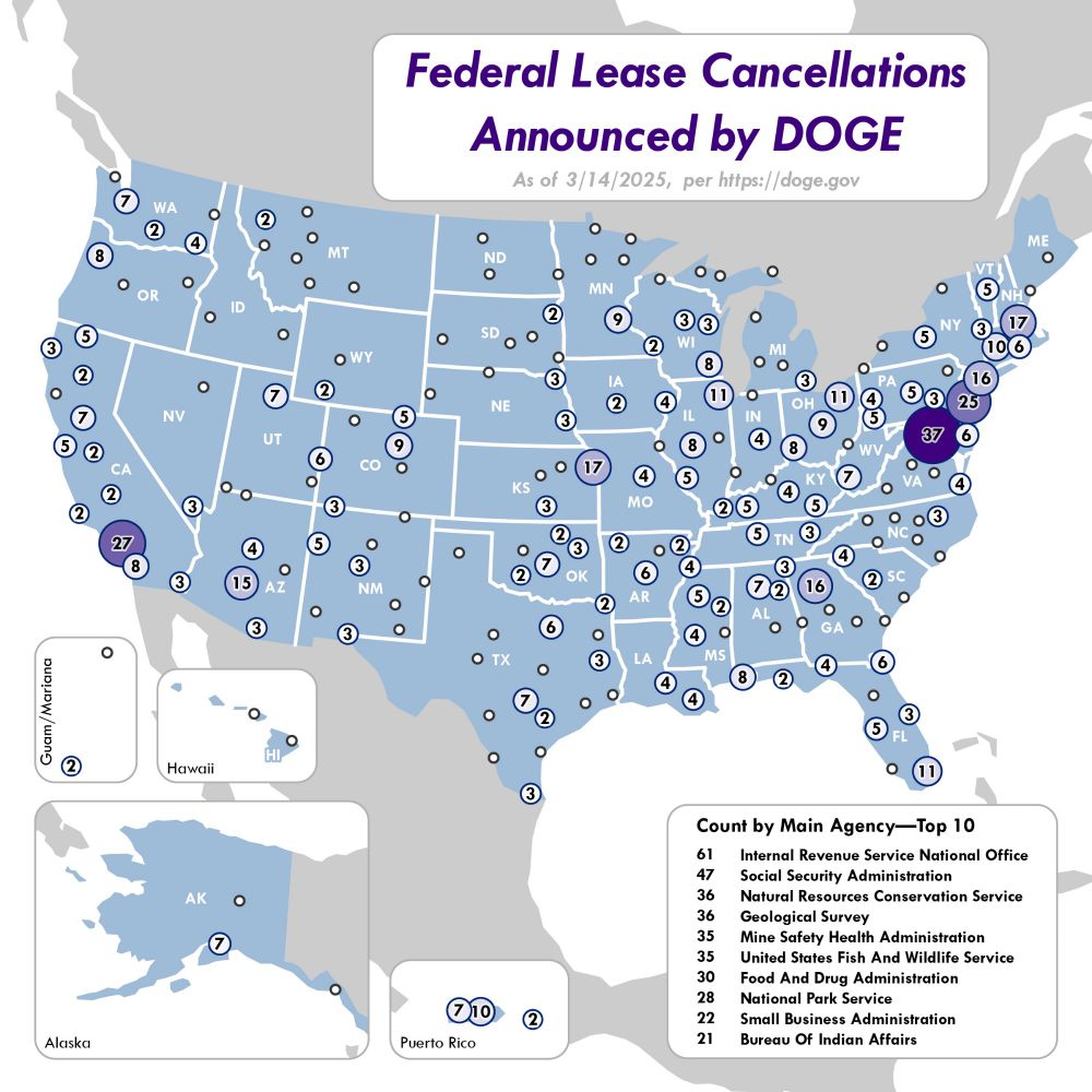
A blue and grey map of the United States and territories showing the number and location of federal lease cancellations, using proportional circles and number labels.
A quick and dirty map I made of the federal lease cancellations announced by DOGE so far. Data from DOGE's website on 3/14/25.
17.03.2025 02:09 — 👍 10 🔁 3 💬 0 📌 0
A few months ago, I made this #StoryMap about glacial relicts and refugia, with a look inspired by botanical field journals. It was a fun side-project to reseach and create. storymaps.arcgis.com/stories/9b04...
03.03.2025 14:42 — 👍 2 🔁 0 💬 0 📌 0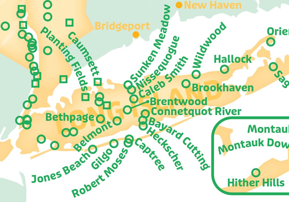
A map of Long Island NY with green labels and markers over orange land. The labels are dense and often curved to fit.
A particularly tricky round of Cartographer's Tetris
17.02.2025 20:03 — 👍 1 🔁 0 💬 0 📌 0Will v1 or the NES book ever be reprinted?
10.02.2025 05:02 — 👍 1 🔁 0 💬 1 📌 0Nice, love that title text and the landing callouts!
07.02.2025 15:27 — 👍 1 🔁 0 💬 1 📌 0Nice! I have an Arduino lying around somewhere, this makes me want to dig it out again try building something.
29.01.2025 23:30 — 👍 1 🔁 0 💬 0 📌 0That's so cool. Is it running with something like an Arduino or Rasberri Pi inside?
29.01.2025 22:28 — 👍 0 🔁 0 💬 1 📌 0Thanks! Mostly by hand on an iPad, yes. I wrote about it a bit on my website: aaronkoelker.com/taughannock-...
25.01.2025 23:38 — 👍 1 🔁 0 💬 0 📌 0I recall iterating over bands with arcpy/python once, but not sure about model builder. ArcGIS Pro has an Extract Bands tool that might work for that, though
24.01.2025 00:09 — 👍 1 🔁 0 💬 1 📌 0
Maps.com is doing a new series on the mapmaking process and asked me to talk about my map of map turtles. I also recommend the first entry with @peterincan.bsky.social and his awesome wildfire map. www.maps.com/behind-the-m...
16.01.2025 17:08 — 👍 13 🔁 1 💬 0 📌 0Same! I've been enjoying finding all the different ones on walls and such too, there's quite a variety of styles
16.01.2025 16:46 — 👍 0 🔁 0 💬 0 📌 0Love this, are the yellow areas the vineyards?
27.12.2024 16:40 — 👍 0 🔁 0 💬 1 📌 0And there's Bluesky's max vertical image ratio for previews...
20.12.2024 22:19 — 👍 2 🔁 0 💬 0 📌 0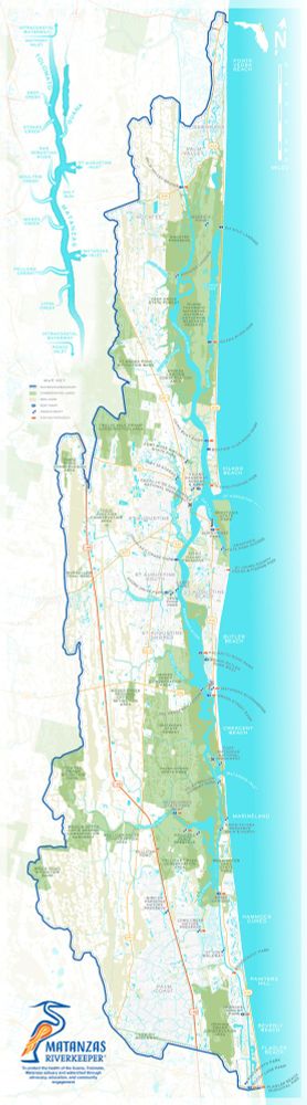
This map covers the Guana, Tolomato, Matanzas estuary and watershed around the city of St Augustine, on the east coast of Florida. It is a tall, narrow image with the ocean in light blue to the right and white land to the left. Conservation areas are shown in light green, while wetlands are a faded olive color. In the top left corner is a abstract water diagram showing the major rivers within the watershed and the tributaries that flow into them. A logo for the Matanzas Riverkeeper and a mission statement sits in the bottom left corner. The logo is the stylized outline of a great blue heron in blue and orange colors.
Recently updated this map for a watershed non-profit group to be vertical instead of horizontal. The original use-case was for tabling events, so we'd made it wide to get more of the map closer to the reader and save them from having to lean forward. The new layout is for signboards at boat ramps.
20.12.2024 22:17 — 👍 10 🔁 1 💬 1 📌 0This was made to support a project on glacial refugia, explaining how the landscape and climate have shifted over time as ice sheets advanced and retreated
13.12.2024 03:10 — 👍 1 🔁 0 💬 0 📌 0Thanks! You sent me down a little rabbit hole on YouTube, neat stuff
13.12.2024 03:06 — 👍 1 🔁 0 💬 1 📌 0Thanks! It can be pretty stark in places. Places like Bloomington it even shows up clear on the aerial imagery, neat to see
13.12.2024 03:05 — 👍 0 🔁 0 💬 0 📌 0Was this in the NACIS map gallery last year? If so I remember staring at it for quite some time. Awesome work!
11.12.2024 21:43 — 👍 0 🔁 0 💬 1 📌 0This animation I made for a recent project shows the changes in ice extent over North America since the last glacial maximum (roughly 18k years). Each frame was hand drawn using Procreate.
11.12.2024 21:28 — 👍 44 🔁 9 💬 2 📌 3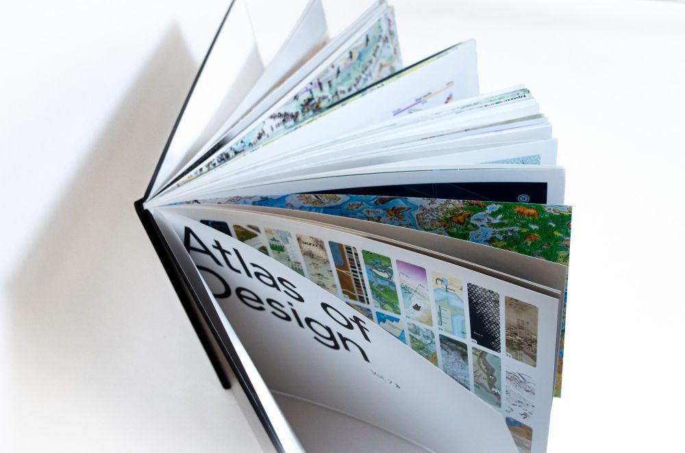
Share the joy of maps with a gift of the Atlas of Design! And why not donate a copy to your local library, school, or book drive? All volumes of the Atlas are now available to ship, including the recently released Volume 7.
atlasofdesign.org/order/
Interesting, I could see that especially for movies that are so bad they're funny
28.11.2024 15:35 — 👍 3 🔁 0 💬 0 📌 0Sounds interesting, I look forward to reading that!
28.11.2024 03:49 — 👍 0 🔁 0 💬 0 📌 0I've been thinking about this a lot lately, and for me it's the usage that decides. I can take a mitten and use it to explain to someone the relative location of a place in Michigan. In that moment it's a map, though we'd never call it one otherwise.
28.11.2024 01:34 — 👍 6 🔁 1 💬 2 📌 0Love that deep green
19.11.2024 01:15 — 👍 2 🔁 0 💬 1 📌 0Oh man, I love that first one! Eyvind Earle tree vibes
19.11.2024 01:10 — 👍 2 🔁 0 💬 1 📌 0