With a $600 satellite dish and open-source software, UCSD & UMD researchers intercepted cleartext IP traffic from 50% of GEO satellite links — voice calls, grid data, in-flight WiFi, retail systems, even military assets. - satcom.sysnet.ucsd.edu/docs/dontloo...
23.10.2025 23:45 — 👍 4 🔁 0 💬 0 📌 0
YouTube video by Marcus Hutchins
Did The Secret Service Really Foil A Plot To Destroy New York's Cellphone Infrastructure?
If you’ve ever wondered where endless scam calls come from… SIM farms. USSS just shut a few down. That’s good news. But no, they weren’t going to knock out every phone in New York. - www.youtube.com/watch?v=TBZj...
25.09.2025 19:10 — 👍 1 🔁 0 💬 0 📌 0
My advisors and I finally submitted our next paper! #PhDChat
11.09.2025 19:11 — 👍 2 🔁 0 💬 0 📌 0

Orbio Earth just open-sourced their full methane detection pipeline—models, tools, synthetic-plume engine & validation notebooks—for Sentinel-2, Landsat 8/9, and EMIT. #Methane #ClimateTech #OpenSource - orbio-earth.github.io/Project-Euca...
08.08.2025 15:46 — 👍 12 🔁 3 💬 0 📌 0

How do we track water flowing through rivers from space? This major review says: 1–3 day revisit. Resolution down to 30–100 m widths. Must include width, slope, & velocity. Flood forecasting + water management depend on it. #EarthObservation #RemoteSensing #WaterResources doi.org/10.1029/2024...
07.08.2025 13:17 — 👍 7 🔁 4 💬 0 📌 0
White House Orders NASA to Destroy Important Satellite
The White House has instructed NASA employees to destroy two major, climate change-focused satellite missions.
The Trump administration is pushing NASA to kill two critical climate satellites. The Orbiting Carbon Observatories track CO₂ globally — data vital to scientists, farmers, and even oil companies. Cost? Just $15M/year. #ClimateScience #EarthObservation futurism.com/white-house-...
06.08.2025 12:43 — 👍 0 🔁 1 💬 0 📌 0
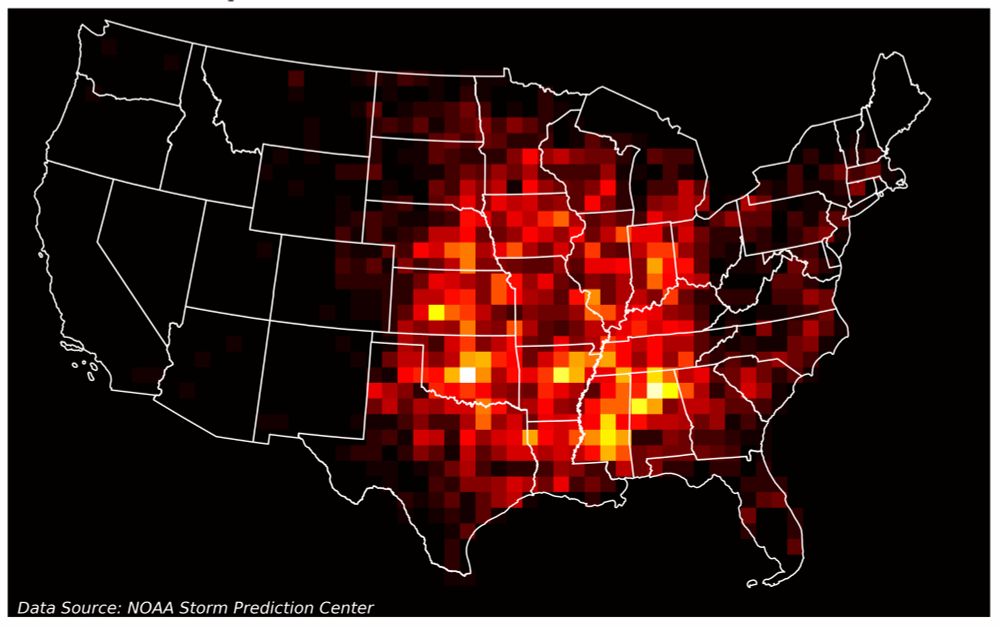
How to Overlay a Heatmap on a Real Map with Python | Towards Data Science
Visualizing historical tornado trends
Want to overlay a heatmap on a real map using Python? This guide walks through visualizing EF3–EF5 tornado trends across the U.S. with NOAA data, grid-based bins, and Matplotlib. Bonus: how to include tornado endpoints too!
#geospatial #Python towardsdatascience.com/how-to-overl...
17.07.2025 17:55 — 👍 6 🔁 0 💬 0 📌 0
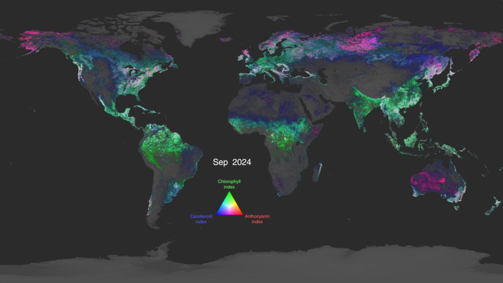
NASA Scientific Visualization Studio | Global Views of PACE Land Vegetation Data
Global view of three major classes of plant pigments observed by the PACE satellite: chlorophylls, carotenoids, and anthocyanins.
NASA’s PACE satellite just dropped a year of stunning hyperspectral data—mapping chlorophyll, carotenoids & anthocyanins globally, every 1–2 days. It's the first time we’re seeing land plants in full spectral color from space. #RemoteSensing #EarthObservation - svs.gsfc.nasa.gov/5548/
03.07.2025 15:04 — 👍 3 🔁 1 💬 0 📌 0
LOL - me too. What's sad is that I just wrote some code for a paper that does this, sort of. This is a better approach, though.
17.06.2025 13:41 — 👍 0 🔁 0 💬 0 📌 0

How I Automated My Machine Learning Workflow with Just 10 Lines of Python | Towards Data Science
Use LazyPredict and PyCaret to skip the grunt work and jump straight to performance.
A great read on automating your ML workflow in just 10 lines of Python. With LazyPredict + pycaret, you can test over 20 models instantly and compare their performance. #MachineLearning #Python #AutoML towardsdatascience.com/how-i-automa...
17.06.2025 13:06 — 👍 1 🔁 0 💬 1 📌 0
YouTube video by Stuckinthe6Ts
God Only Knows - The Beach Boys, a cappella
This is even worse - Brian Wilson just passed away. The Beach Boys are probably my all-time favorite band, and Brian Wilson was an absolute treasure. www.youtube.com/watch?v=OvNX...
11.06.2025 16:47 — 👍 1 🔁 0 💬 0 📌 0
YouTube video by The Ed Sullivan Show
Sly And The Family Stone "I Want To Take You Higher" on The Ed Sullivan Show
So sad to hear of Sly Stone's passing. Absolutely loved him and the Family Stone. www.youtube.com/watch?v=WG_x...
10.06.2025 14:11 — 👍 1 🔁 0 💬 0 📌 0

ChatGPT just released Codex. You can connect to a GitHub repository, and it will explain the codebase to newcomers, suggest codebase improvements, and identify and fix critical bugs. Then do a pull/merge request! Kind of awesome. chatgpt.com/codex/ #vibecoding #chatgpt #codex
06.06.2025 13:33 — 👍 1 🔁 0 💬 0 📌 0

New Satellite Images Capture Mount Etna’s Massive Eruption
Satellite images show Mount Etna's major eruption on June 2nd, 2025, releasing a large plume of sulf...
Satellite images show Mount Etna's major eruption on June 2nd, 2025, releasing a large plume of sulfur dioxide & ash. ESA's Sentinel-5P & Sentinel-2 missions captured the event. #MountEtna #News
05.06.2025 13:19 — 👍 2 🔁 2 💬 0 📌 0
YouTube video by ThePrimeTime
NASAs Coding Requirements Are Insane
NASA’s “Power of 10” for safety-critical code is awesome. No recursion. No dynamic memory after init. No function > 60 lines. Every return value is checked. Brutal but beautiful. Great video review. #CleanCode www.youtube.com/watch?v=JWKa...
02.06.2025 15:41 — 👍 4 🔁 1 💬 1 📌 0
YouTube video by Jared Henderson
The American Literacy Crisis, Explained
Is America facing a literacy crisis? Not exactly. But 40% of 4th graders can't read at a basic level. And 28% of adults are functionally illiterate. The real problem? It's been bad for a long time—and it's getting worse. But Mississippi shows it's fixable. #reading www.youtube.com/watch?v=ZvCT...
30.05.2025 16:53 — 👍 0 🔁 0 💬 0 📌 0

Trump administration bars Harvard from enrolling foreign students
Trump admin. revoked Harvard's ability to enroll international students, impacting nearly 6,800 stud...
Trump admin. revoked Harvard's ability to enroll international students, impacting nearly 6,800 students. The action follows accusations of harboring anti-American agitators & CCP ties. Harvard disputes claims. #HigherEducation #News
23.05.2025 04:55 — 👍 0 🔁 1 💬 0 📌 0
GitHub - Eric-Ness/my-ai-project
Contribute to Eric-Ness/my-ai-project development by creating an account on GitHub.
Based on the article I came across yesterday, I put this together. It's an 'LLM-Assisted Project Development Template'. I am unsure if it works entirely, but I will test it out. Not sure if anyone else is playing with this type of development. github.com/Eric-Ness/my...
13.05.2025 13:37 — 👍 0 🔁 0 💬 0 📌 0

Sahar’s Coding with AI guide
How to treat your AI coding agent (Cursor/Windsurf/Cline) as a human pair programmer and yield the best results
I really like this tutorial – defining .cursor/rules as your AI’s “operating manual” keeps context consistent and cuts down on misfires. #AICoding #PairProgramming - www.aitidbits.ai/p/sahar-ai-c...
12.05.2025 15:20 — 👍 1 🔁 0 💬 0 📌 0
Check out creative ways to export your maps from QGIS to Illustrator — then bring them to life with animations in Premiere!
#QGIS #Illustrator #PremierePro #MapDesign - www.chiaraphillips.com/post/make-th...
11.05.2025 12:15 — 👍 4 🔁 0 💬 1 📌 0

Trump admin ends extreme weather database that has tracked cost of disasters since 1980
NOAA retired its billion-dollar weather disaster database, ending public tracking of extreme weather...
NOAA retired its billion-dollar weather disaster database, ending public tracking of extreme weather costs since 1980. The database will be archived but not updated. #ClimateChange #News
09.05.2025 12:18 — 👍 0 🔁 1 💬 0 📌 0

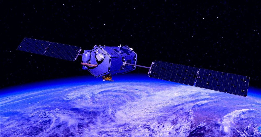
ESA unveils longest-ever dataset on forest biomass
As the new Biomass satellite settles into life in orbit following its launch on 29 April, ESA has released its most extensive satellite-based maps of above-ground forest carbon to date. Spanning nearl...
ESA’s new Biomass Dataset v6 delivers the longest-ever satellite-based record of above‑ground forest carbon (2007–2022), mapping trunks & branches at 100 m–50 km resolution. A game‑changer for climate & carbon modelling! #ForestBiomass #ClimateAction www.esa.int/Applications...
09.05.2025 13:34 — 👍 0 🔁 1 💬 0 📌 0

Over 90 technician vacancies threaten Doppler radar & surface station upkeep, risking prolonged outages when storms hit. Since Trump’s second term began, @noaa.gov has lost 550+ employees—the same number lost in the previous 15 years combined. #Meteorology - edition.cnn.com/2025/05/02/w...
09.05.2025 13:31 — 👍 0 🔁 0 💬 0 📌 0

So I have been busy working on this as of late. It's been a lot of fun.
08.05.2025 14:00 — 👍 1 🔁 0 💬 0 📌 0
A culture and education website that tries to make the web a more intelligent place. Features free courses, movies, audio books, ebooks & thought-provoking daily posts.
Find us at: https://www.openculture.com/
Kali Linux, The Most Advanced Penetration Testing Distribution. Ever.
President of Signal, Chief Advisor to AI Now Institute
researching viral pathogen genomics at @lshtm.bsky.social | theo.io / sandersonlab.org
THE University of the Year 2023
Anglia Ruskin University has campuses in Cambridge, Chelmsford, Writtle and Peterborough. Need help? Email answers@anglia.ac.uk
Satellite images past and present 🛰️
Building an archive of interactive declassified spy satellite images 🕵️
https://spacefromspace.com/declassified-satellite-images
I make "The Ideas that Explain the News" on YouTube - using concepts from social sciences to explain the news at a deeper level.
https://brendanmiller.substack.com/
I like chatting politics/books/meeting people - message if you fancy coffee!
I teach history at a community college and publish when I feel like it. For music stuff see @joelmusic.bsky.social
🔥🗺️ Pyrogeographer.
🛰️🛩️🔥 #RemoteSensing of #Wildfire.
❤️🚒 Passionate about finding ways to help emergency responders.
📣 #SciComm
👩💻 https://www.kristaleewest.com/
📍 Colorado, USA
High-quality datasets designed to spark ideas, solve problems, and drive innovation. Fresh data added all the time for your AI projects, research, or curiosity. Let’s turn raw numbers into real impact 🚀
Theoretical Physicist.
(She/her/hers)
From Eastern KY.
Creator of Have I Been Pwned. Microsoft Regional Director. Pluralsight author. Online security, technology and “The Cloud”. Australian.
🏳️⚧️🇵🇷 Clinical Instructor, Harvard Law Cyberlaw Clinic. Gender & Tech. Views = my own. She/Her.
Read my work at thedissident.news
🛰️📡 Unofficial mirror/fan account for the Landsat Program, a series of Earth-observing satellites co-managed by USGS & NASA, imaging the Earth since 1972. Posts do not necessarily reflect the views of USGS or NASA.
THE place on Bluesky to see video clips from seminal comedy show Mystery Science Theater 3000!
Please visit mst3k.com, rifftrax.com, and themadsareback.com for more
Visit our site to find all the places you can stream and own Mystery Science Theater 3000: www.mst3k.com
I am America’s Best Christian™. But you knew that. You can find exclusive content here: https://www.patreon.com/c/MrsBettyBowers
TITHE: https://www.paypal.com/donate/?hosted_button_id=Q6REDKBBVUJLU