Relocated seismicity associated with the December 2024 Yerington, Nevada earthquake helps scientists explore whether the culprit was not just one, but two faults. Find out more in #SRL. ⚒️
pubs.geoscienceworld.org/ssa/srl/arti...

@jugkariche.bsky.social
Relocated seismicity associated with the December 2024 Yerington, Nevada earthquake helps scientists explore whether the culprit was not just one, but two faults. Find out more in #SRL. ⚒️
pubs.geoscienceworld.org/ssa/srl/arti...

🌟OPEN ACCESS🌟The Role of “Equation Error” in Empirical Regressions for Seismic Magnitude Conversions #BSSA ⚒️
What’s the best way to convert between traditional magnitude and moment magnitude?
pubs.geoscienceworld.org/ssa/bssa/art...

New simulations of earthquake cycles on geometrically rough faults show an interplay between slow sip, creep and foreshocks leading to rupture of the entire fault. #BSSA⚒️
pubs.geoscienceworld.org/ssa/bssa/art...

Fig. 4 from the paper. Top left: epicenter locations from August 20, 2021 to February 6, 2022 in the NLL-SC catalog. Events are color-coded by hypocenter depth and sized with respect to their magnitude. The blue circle marks the mainshock of August 14, 2021 (M 7.2) from Calais et al. (2022), shifted in location on the map to avoid cluttering the aftershock distribution. The black boxes delimit zones 1, 2, and 3, separately described in the text. Black lines show the main active faults as in Calais et al. (2023): EPGF, Enriquillo Plantain Garden Fault; RF, Ravine du sud Fault; JMF, Jérémie-Malpasse Fault, as well some cities: J, Jérémie; A, Anse-à-Veau; M, Miragoâne. Bottom left and top right: hypocenter depths projected along east–west and north-south cross-sections. Bottom right: histogram of hypocenter depth with 2 km interval bins.

Fig. 12 in the paper. Interpretative synthetic cross-section of the study area. Earthquake hypocenters, plotted with white dots, are actual hypocenters from sections 6 and 14 on Fig. 5. Main faults inferred are shown with solid black lines. The fault segments involved in the 2021 Nippes earthquake sequence described in this paper are highlighted with a dashed red line. The yellow star indicates the nucleation location of the M 7.2 Nippes earthquake from Calais et al. (2022).
🤑OPEN ACCESS🤑 In a new paper, lead by Sylvert Paul, we precisely relocate the 2021 M 7.2 Nippes, Haiti, earthquake sequence using broadband and low-cost, citizen-hosted, seismometers.
Strain is partitioned on strike-slip, reverse, and obliquely-slipping faults.
authors.elsevier.com/sd/article/S...

Earthquake Roundup for Sept 16 - Nov 13, 2025. We have 744 located earthquakes and the largest was a Mw 3.8. We are still watching the Battle Mountain area and seeing some newer clusters of activity in Central Nevada learn more in this Roundup Video: tinyurl.com/5c7w5jbr
14.11.2025 21:55 — 👍 5 🔁 2 💬 0 📌 0
In a new #SRL paper, scientists explore how much the width of the seismogenic zone varies with depth for the the San Andreas, the Dead Sea, the North Anatolian, and the East Anatolian faults. ⚒️
pubs.geoscienceworld.org/ssa/srl/arti...

⚒️ 🧪
A M6.8 earthquake struck offshore Japan today - another large earthquake from the subduction zone that produced two recent great earthquakes. The earthquake was preceded by a "cascade up": foreshocks progressively increasing in maximum magnitude.
What do we know? What might happen next?
This visualization of Japan’s M6.8 yesterday is phenomenal. Offshore S-net detected it and issued earthquake alert before any land station detection. Numbered circles show JMA intensity (not same as MMI). Offshore is where we need to be in Cascadia as well.
10.11.2025 16:10 — 👍 26 🔁 7 💬 0 📌 0
🌟OPEN ACCESS🌟The 1884 Andalusian Earthquake, Spain: Re‐evaluation of Seismic Intensities and Source Determination #SRL ⚒️
What was the geometry of the fault that ruptured in the 1884 Andalusian earthquake?
pubs.geoscienceworld.org/ssa/srl/arti...

"Who benefits when a country aims to be a world leader in AI without addressing basic social problems? What value exists in developing the most powerful AI models when such innovations further exacerbate existing social ills?"
www.science.org/doi/10.1126/...

🌟OPEN ACCESS🌟 In a new #BSSA paper, scientists leverage a dense seismic network, deployed in a complex region with abundant microseismicity, with machine-learning methods. The result illuminates structures and fault geometries. ⚒️
pubs.geoscienceworld.org/ssa/bssa/art...

In a new #BSSA paper, scientists study the largest instrumentally recorded quake, the 1952 magnitude 6.3 suburban Pyongyang earthquake. ⚒️
pubs.geoscienceworld.org/ssa/bssa/art...
Dealing with earthquake hazard and risk is a complex and nuanced problem, with no easy answers. For the most part, the scientific experts think the changes announced today are a positive step forward
29.09.2025 03:04 — 👍 25 🔁 14 💬 0 📌 1
A detailed analysis of seismic and satellite data that recorded the September 2023 High Atlas, Morocco earthquake provides a detailed picture of the geologic structures in the region. For more, please visit this #BSSA paper. ⚒️
pubs.geoscienceworld.org/ssa/bssa/art...

SeisBench v.10 is out and it's time for some new models:
- SkyNet allows picking regional phases and can even distinguish Pn, Pg, Sn, Sg (beware of the Terminator though)
- SeisDAE brings easily retrainable seismic waveform denoising
Check out all changes here:
github.com/seisbench/se...

📢 Paper Alert!
Excited to share my new paper in Pure and Applied Geophysics: “Role of Fluid on Earthquake Occurrence”.
We show how fluids -b-value drops help shape foreshocks & aftershocks in Ridgecrest (2019) & Central Apennines (1997, 2009, 2016).
👉 link.springer.com/article/10.1...
Weekly Earthquake Stats: 07 Sep 2025 - 13 Sep 2025. There were 404 events this week ranging from M -0.21 to 3.69. Check out our weekly playback map and visit www.scsn.org for detailed information. #earthquakes #seismology #SCSN #weeklystats @CaltechSeismo
14.09.2025 21:00 — 👍 4 🔁 2 💬 0 📌 1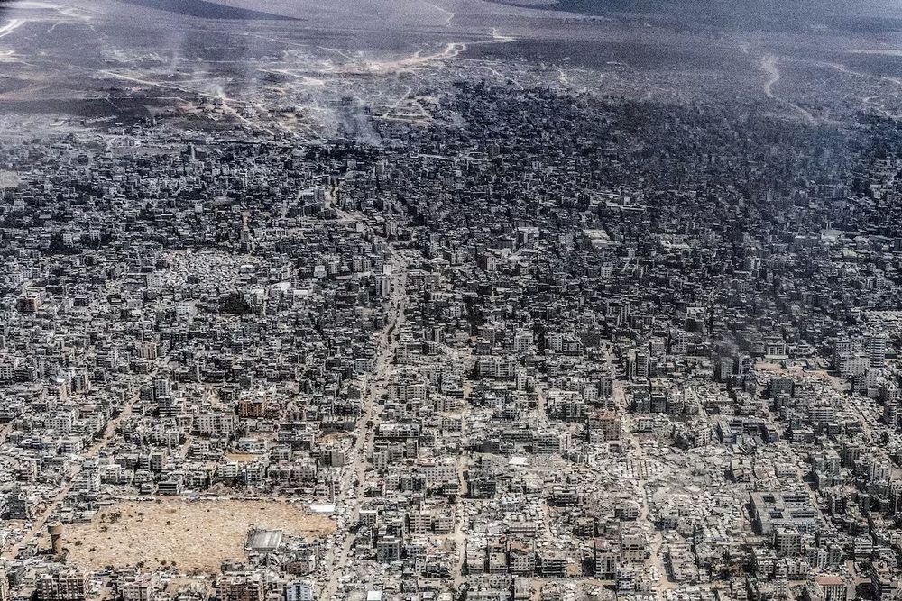
An aerial view of Gaza City taken from a Jordanian military aircraft by photojournalist Heidi Levine in July 2025. Massive destruction is visible, as are IDP tents.
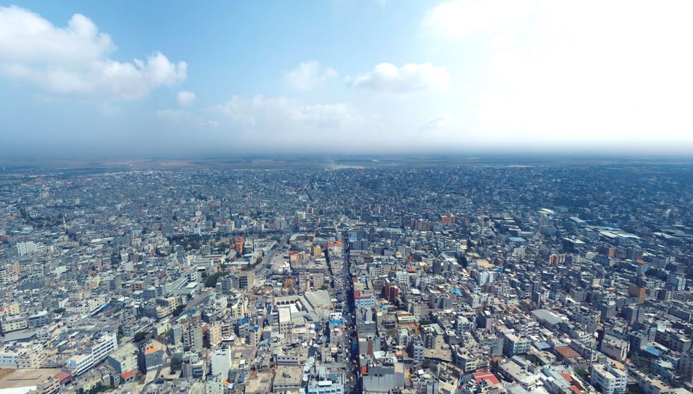
An aerial photo taken from a drone photographer in 2019 showing Gaza City's Old Town facing east, providing a view similar to the aerial photo taken in July 2025.
For another comparison, there's also an aerial view from a similar perspective, though at lower altitude since it's from a drone photographer, here on Facebook from 2019: www.facebook.com/photo/?fbid=...
The drone photo is closer to 31.5057, 34.4619 whereas the plane photo is closer to the coast.

Auto slipmap with regional records (SLIPNEAR method, Géoazur/OCA) M 7.3 - ALASKA - 2025-07-16 20:37:39 (UTC)
Plane striking N343 (NNW-SSE) shown.
Rupture direction to the South-East constrained by nearby stations (quite opposite to the USGS result).
Thanks to seismic records through IRIS
🌍📢 New Publication Alert | Geology – July 2025 🧭📡
In response to Viltres et al. (2025), our analysis provides no evidence supporting the presence of aseismic creep along the Mila-Guelma Fault in Tell Atlas region (Algeria).
🔗 DOI: doi.org/10.1130/G533...

🔔📢 Publication Announcement: Full paper Now Available
I am pleased to share that our article, published in Tectonophysics, is now available in open access.
You can access the full text at the following link: 👉
www.sciencedirect.com/science/arti...