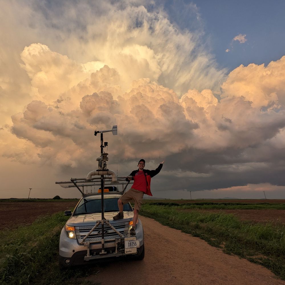
Prairie clouds
21.12.2025 23:52 — 👍 3 🔁 0 💬 0 📌 0
@cloudprophet.bsky.social
Research meteorologist at NSF NCAR, specializing in tropical meteorology and the science behind weather prediction. Hurricane aficionado. 🇺🇸/🇩🇪
Prairie clouds
21.12.2025 23:52 — 👍 3 🔁 0 💬 0 📌 0
Timelapse of a severe downslope wind storm in Boulder, Colorado.
Clouds cresting over the Front Range and cascading downward. The "dust front" with the strongest winds kept sweeping eastward from the base of the foothills.
A peak wind gust of 71 mph was recorded at my location during the event.

Join us for a critical conversation on the future of U.S. atmospheric science.
UCAR President Antonio Busalacchi hosts this town hall on what’s at stake if NSF NCAR is dismantled.
buff.ly/jR6tGwo

Advancing the science of meteorology isn't liberal or conservative, it's common sense. Fight for your forecast--and the research that makes it possible.
Some thoughts I put together today on the administration's NCAR destruction announced today:
Press release about our ongoing forecast demonstration with a global 3.75-km MPAS:
news.ucar.edu/133040/scien...


Four days before Typhoon Ragasa’s rainbands hit Taiwan, the 3.75-km MPAS predicted >36" of rain in the mountains—while the 15-km parallel run only showed up to 24".
By better resolving Taiwan’s terrain and upslope rainfall, the high-res run shows the value of higher resolution in complex terrain.
Four days before Typhoon Ragasa’s rainbands hit Taiwan, the 3.75-km MPAS predicted >36" of rain in the mountains—while the 15-km parallel run only showed up to 24".
By better resolving Taiwan’s terrain and upslope rainfall, the high-res run shows the value of higher resolution in complex terrain.
While our experimental 3.75-km MPAS forecast did not move the storm as quickly as in reality—placing it farther east and farther from land—it nevertheless captured a super typhoon before the system was even named #Ragasa
👉 project.mmm.ucar.edu/real-time-fo...

18-Sep 00Z MPAS forecast has a major typhoon aiming at the Luzon Strait in three days. This system hasn't even formed yet, so we'll see.
👉 project.mmm.ucar.edu/real-time-fo... Variable: Infrared Brightness Temp, Domain: Invest 90 (WP90)

Today's tidbit from @ncar-ucar.bsky.social's experimental 3.75-km MPAS forecasts: An active train of African easterly waves.
- a squall line over western Africa
- a tropical storm near 30°W
- another less well defined tropical system near 45°W
👉 project.mmm.ucar.edu/real-time-fo...


While a Mesoscale Convective System did form this evening over the Colorado plains (left), the MPAS forecast had it farther north than observed (right)
10.09.2025 04:18 — 👍 0 🔁 0 💬 0 📌 0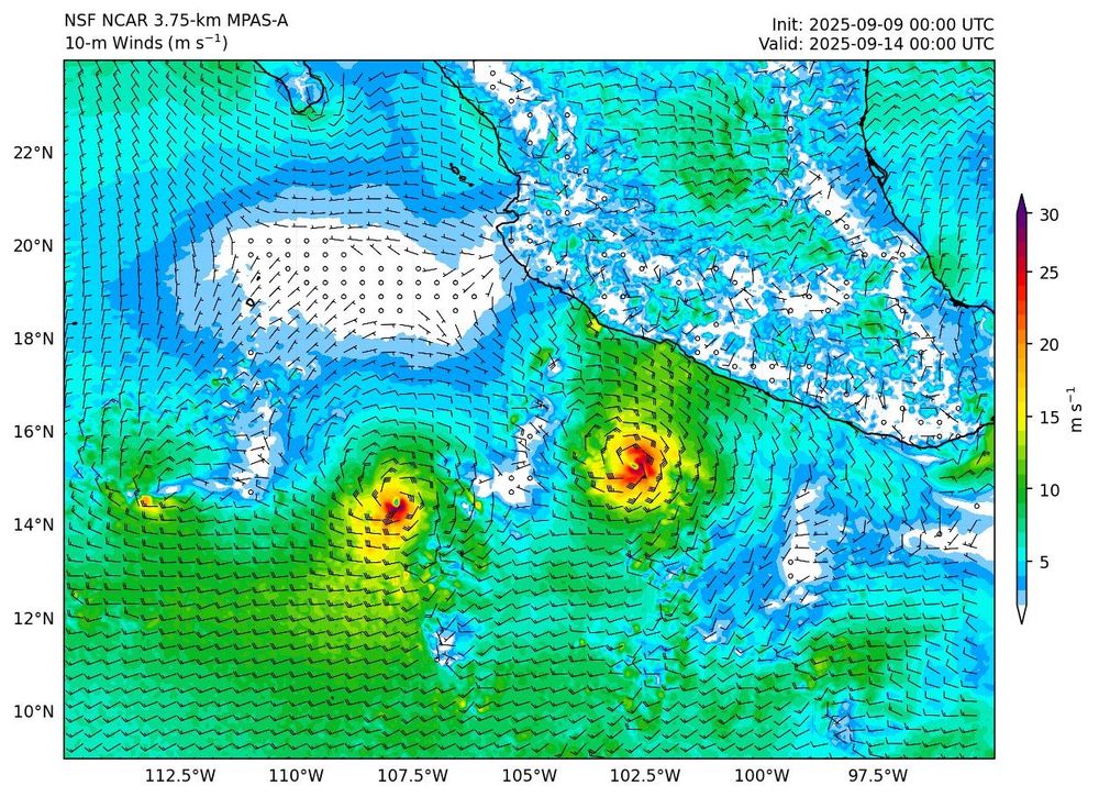
Today's #MPAS forecast has two cyclones in the eastern Pacific that appear to be locked in a Fujiwara-like fashion.
👉 project.mmm.ucar.edu/real-time-fo...
variable: 10-m Winds, domain: EPAC (zoom), forecast hour 120

One advantage of high-resolution global models is their ability to resolve topography and its influence on weather. In this 5-day accumulated rainfall forecast for Puerto Rico, the model predicts little to no rain along the southern coast but more than 200 mm (8 inches) in the northwestern interior.
06.09.2025 01:47 — 👍 11 🔁 2 💬 1 📌 0MPAS brings Hurricane Kiko close to Hawaii (as a 45-kt tropical storm) in ~4 days creating some interesting topographical flow features
👉 project.mmm.ucar.edu/real-time-fo...
Variable: 10-m Winds, Domain: Hawaii

🌍 The MMM lab at @ncar-ucar.bsky.social is running experimental realtime forecasts with a global 3.75-km MPAS model.
Goal: Highlight the power of global km-scale models for weather prediction from local to planetary scales, incl. tropical cyclones.
👉 project.mmm.ucar.edu/real-time-fo...

Tired of guessing how many core-hours your MPAS run will devour? My new script (github.com/falkojudt/mp...) helps you to get the numbers.
24.03.2025 22:17 — 👍 1 🔁 0 💬 0 📌 0Trade wind cumulus at work, transporting moisture from the boundary layer into the free troposphere
05.01.2025 23:56 — 👍 1 🔁 0 💬 0 📌 0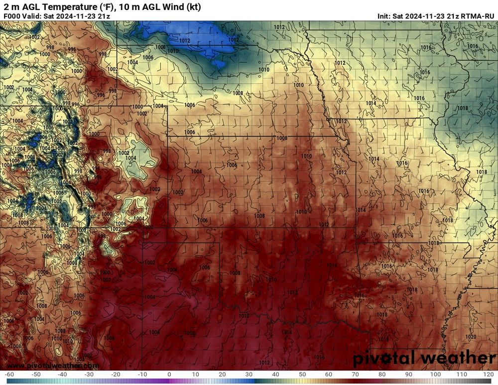
The downslope flow drove temperatures into the mid to upper 60s (~18C) on the eastern slopes with little humidity. There’s still some snow cover over Colorado the high plains, which creates some local cold patches.
24.11.2024 00:18 — 👍 1 🔁 0 💬 0 📌 0
Down near the surface, there was a lee trough east of the front range, which helped to drive downslope flow.
24.11.2024 00:18 — 👍 0 🔁 0 💬 1 📌 0
In the upper levels, there’s a ridge over Colorado, westerly flow, and an upstream a trough over the Pacific. This set up brings in some upper level moisture which often produced wave clouds, which we had today (though the clouds broke over Boulder).
24.11.2024 00:18 — 👍 0 🔁 0 💬 1 📌 0
A beautiful mild late autumn day by Boulder creek.
So, what’s going on meteorologically? #cowx
Great example of a “cyclone train”, where each storm takes a similar path to the previous one.
Big question is: are these “trains” predictable on S2S time scales (weeks in advance)?


Flying is such a privilege. I can spend hours 👀 all the landmarks and the weather from above…
(1) Golden, CO and its table mountains
(2) Berthoud Pass
(3) Rocky🏔️ after the first ❄️, barren South Park in the background (Copper ⛷️ peaks out, too)
(4) Fog moving into dry hills near San Francisco