Neues zum Thema Populärmusik transnational in den langen 1960er Jahren!
11.04.2025 07:59 — 👍 1 🔁 0 💬 0 📌 0

Fraternisations aux armées pendant les deux guerres mondiales
💬 "Ils entendent les soldats de l’autre côté du no man’s land parler, rire, pleurer... Pourtant ennemis, ils se trouvent des points communs." (@mafawi.bsky.social)
🔴 Ressource pédagogique (lycée - #Histoire - Première) 👇
ehne.fr/fr/eduscol/p...
🤝 @aphg.bsky.social @lettres-sorbonne.bsky.social
28.03.2025 07:45 — 👍 6 🔁 9 💬 0 📌 0
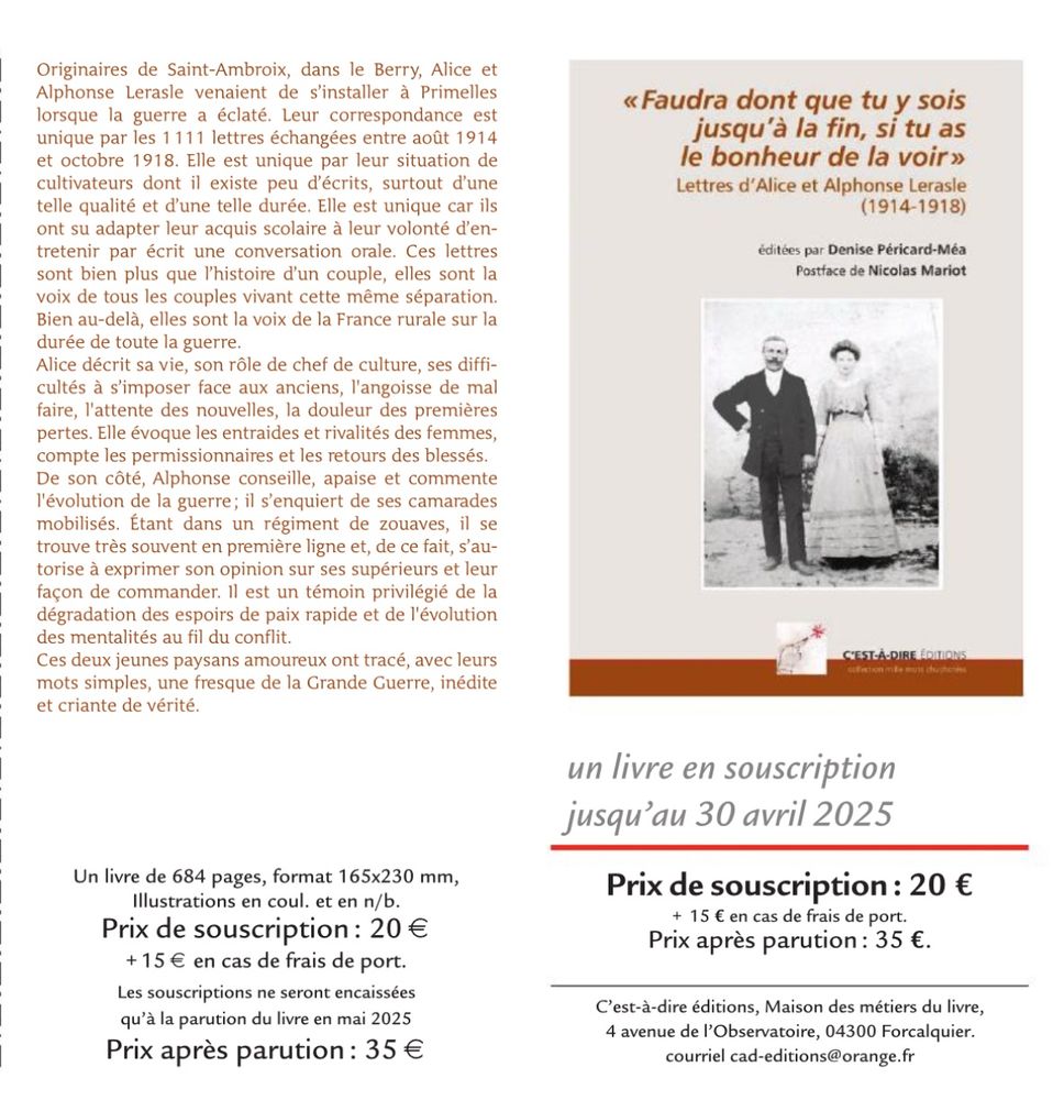
Couverture et 4e de couv des lettres d’Alice et Alphonse Lerasle
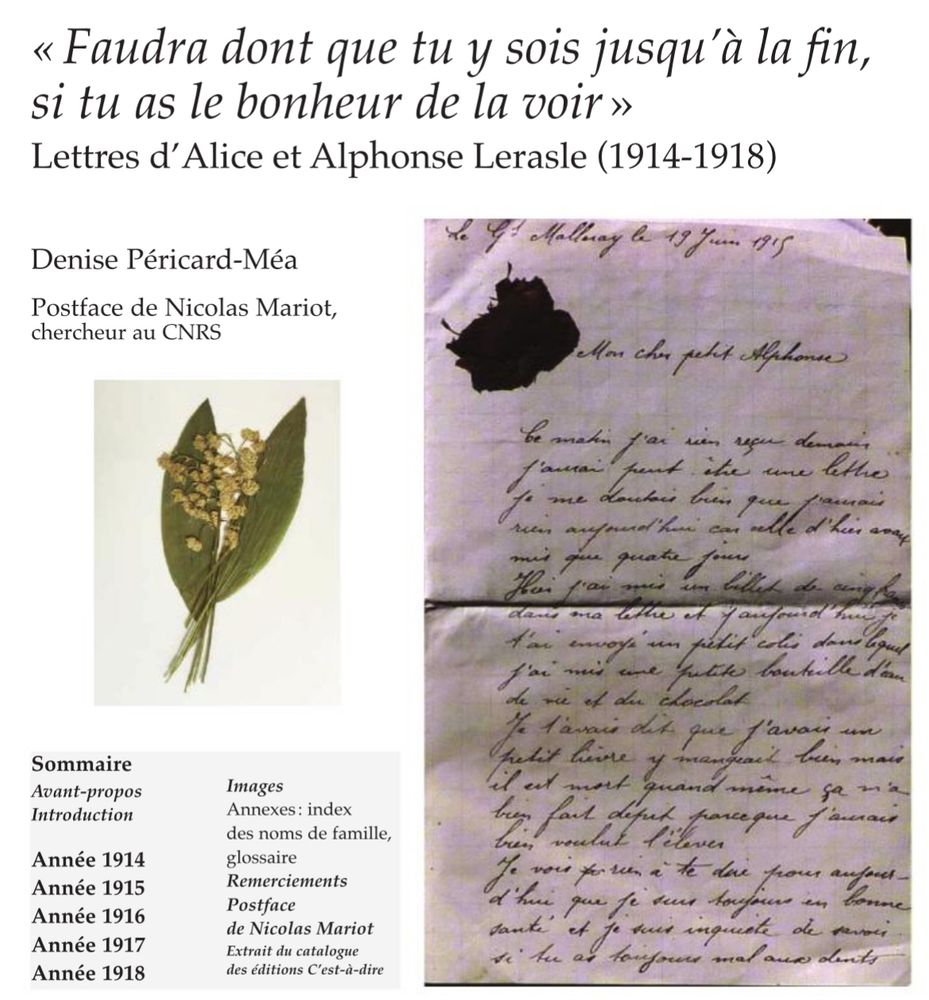
Extrait
Bulletin de souscription
Un beau projet éditorial 1e GM qui pourra voir le jour via cette souscription : correspondance d’un couple paysan dans la guerre, un type de document en réalité très rare (alors qu’ils furent le groupe majoritaire au front comme à l’arrière). Postface de Nicolas Mariot.
À partager et diffuser !
25.03.2025 18:09 — 👍 52 🔁 20 💬 3 📌 1
De la propagande au front au front de propagande
💬 "Jusqu’à la Première Guerre mondiale, l’improvisation dictait la propagande au front. Par la suite, cette pratique s’institutionnalise." (@mafawi.bsky.social)
🔴 Ressource pédagogique pour le lycée (Première – #HGGSP)
🤝 @aphg.bsky.social @lettres-sorbonne.bsky.social
ehne.fr/fr/encyclope...
10.02.2025 12:35 — 👍 8 🔁 5 💬 0 📌 0
🎮 What about playing with a #PhD thesis?
Find the ananachronisms in the #19thcentury reconstruction of 'Vieux Paris' in the videogame based on @elisa-chazal.bsky.social 's doctoral research 👇
🎮 #DigitalHistory #skystorians #VisualHistory
31.01.2025 14:44 — 👍 4 🔁 2 💬 0 📌 0
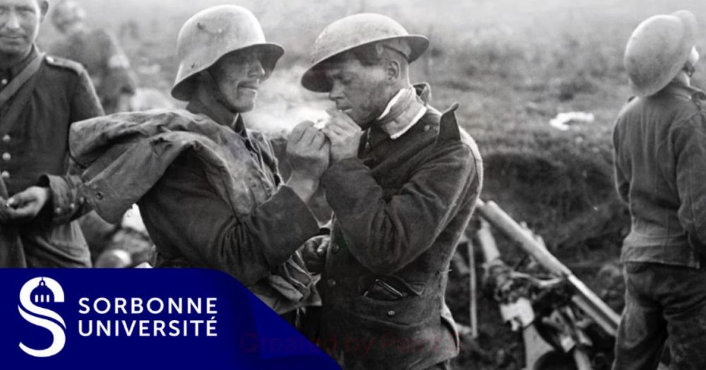
Fraternization in the Armed Forces during the two World Wars.
Fraternization in the Armed Forces during the two World Wars.
👋On this #InternationalDayOfHumanFraternity, discover the #history of fraternization in armed forces during the world wars.
An article ✍️by historian Maude Williams.
(@mafawi.bsky.social - @uni-saarland.de )
#warstudies #worldwars #fraternization #soldiers
👉 ehne.fr/en/encyclope...
04.02.2025 12:05 — 👍 4 🔁 6 💬 0 📌 0

Key Terms of Public History
This volume introduces key terms of public history and makes them accessible via the most important subject areas and central research perspectives. It is aimed at students, teachers and practitioners...
🚨Full Open Access 🚨 "Key Terms of Public History"
A @c2dh.uni.lu book series with @degruyterbrill.bsky.social
Edited by @cgpublichistory.bsky.social the book explores debates on authenticity, #heritage, #memory, emotion, and others.
#publichistory #history
www.degruyter.com/document/doi...
03.02.2025 05:10 — 👍 11 🔁 8 💬 0 📌 0

Only 1 week left to submit your paper for the Day of Contemporary History in the Greater Region (25.04.2025) 📣
Scholars, early-career researchers,students, seize the opportunity to present innovative research, engage in critical discussions, and foster collaborations
👉 www.uni.lu/c2dh-en/news...
24.01.2025 07:06 — 👍 4 🔁 3 💬 0 📌 0

Remember the people who lived in Luxembourg before and during World War II and were persecuted by the Nazis. Follow their fate on memorialshoah.lu/en/
#HolocaustRemembranceDay #ww2
27.01.2025 07:26 — 👍 7 🔁 1 💬 0 📌 0

More than 1.200 persons considered as Jews by the Nazis living in Luxembourg before the war were deported. Dive into this chapter of Luxembourg history with our digital exhibition 👉 ww2.lu 👈
#holocaustremembranceday #ww2
27.01.2025 11:32 — 👍 6 🔁 1 💬 0 📌 0

#Conférence
🔎🗺️ Ce 6 février à 18h15, assistez à la conférence @labnf.bsky.social "Expositions cartographiques et espaces urbains (Paris, XVIIIe-XXe siècle)" de Jean-Marc Besse, directeur d'études de l'EHESS @geographie-cites.bsky.social.
📍 5 rue Vivienne 75002 Paris
➡️ www.bnf.fr/fr/agenda/ex...
02.02.2025 18:11 — 👍 6 🔁 3 💬 0 📌 0

Poster du colloque
La semaine prochaine à Strasbourg: Le colloque "Vies en guerre : Alsace 1939–1945" dans le cadre des commémorations des 80 ans de la #Liberation de la France
05.02.-07.02. | 9h30-17h | Organisation: Univ. Strasbourg
Programme: arche.unistra.fr/act...
www.dhi-paris.fr/fr/...
#CIERA
31.01.2025 15:06 — 👍 4 🔁 3 💬 0 📌 0

The Oxford Seminars in Cartography (TOSCA)
Join our Bodleian Map Team and contributors for a series of talks on cartography
If maps are your thing: The Oxford Seminars in Cartography (TOSCA) return for 2025!
Running since 1993, interested cartographers meet for a programme of lectures and field trips exploring all facets of mapping and cartography. The first event is Thursday (Jan 30) visit.bodleian.ox.ac.uk/tosca
27.01.2025 10:43 — 👍 75 🔁 12 💬 2 📌 0
Et voici également un autre kit qui rassemble les revues d'histoire, en France et à l'étranger:
go.bsky.app/7QNaJcZ
20.01.2025 09:28 — 👍 45 🔁 16 💬 0 📌 1

L'Allemagne et au-delà | 400013629
Cet hommage à Hélène Miard-Delacroix, historienne et germaniste, pour son 65e anniversaire rassemble les contributions de ses collègues, doctorant.es et habilitant.es et traite des sujets qui lui sont...
Sortie des mélanges en l’honneur d’Helene Miard-Delacroix chez Franz Steiner, dirigé par @vdubslaff.bsky.social , Agathe Bernier-Monod, Elisa Goudin-Steinmann. Avec mon chapitre sur la culture de la confidentialité dans l’athéisme scientifique : www.steiner-verlag.de/en/L-Allemag...
18.12.2024 22:57 — 👍 6 🔁 3 💬 0 📌 0

Plugin Update – December, 2024
<p>In December, there were 37 new plugins published in the <a href="https://plugins.qgis.org/plugins/"><strong>QGIS plugin repository</strong>.</a></p>
<p>Here follows the quick overview in reverse chronological order. If any of the names or short descriptions catches your attention, you can find the direct link to the plugin page in the table below: </p>
<figure class="wp-block-table"><table class="has-fixed-layout"><tbody><tr><td><a href="https://plugins.qgis.org/plugins/filtra_selecionados/"><strong>Filtra Selecionados | Filter Selected</strong></a></td></tr><tr><td>Filtra a camada ativa com base nas feições selecionadas, considerando a estrutura e os tipos de campos para uma filtragem otimizada. | Filters the active layer based on selected features, considering the structure and field types for optimized filtering.</td></tr><tr><td><a href="https://plugins.qgis.org/plugins/french_point_elevation/"><strong>French Point Elevation</strong></a></td></tr><tr><td>Récupère l’altitude à partir du RGE ALTI® (IGN, FRANCE).</td></tr><tr><td><a href="https://plugins.qgis.org/plugins/ravi/"><strong>RAVI</strong></a></td></tr><tr><td>Remote Analysis of Vegetation Indices.</td></tr><tr><td><a href="https://plugins.qgis.org/plugins/mgbinputtool/"><strong>MGBInputTool</strong></a></td></tr><tr><td>This plugin prepares the data for the MGB-IPH model.</td></tr><tr><td><a href="https://plugins.qgis.org/plugins/integrator_uslug_danych_przestrzennych/"><strong>Integrator usług danych przestrzennych</strong></a></td></tr><tr><td>Narzędzie stworzone dla użytkowników QGIS, które umożliwia szybki i bezpośredni dostęp do danych przestrzennych pochodzących z oficjalnej ewidencji zbiorów i usług danych przestrzennych kraju (EZiUDP). To najlepszy sposób pracy z polskimi danymi przestrzennymi, jeśli na co dzień z nich korzystasz.</td></tr><tr><td><a href="https://plugins.qgis.org/plugins/basemaps/"><strong>Basemaps</strong></a></td></tr><tr><td>A QGIS plugin to load multiple online basemap services.</td></tr><tr><td><a href="https://plugins.qgis.org/plugins/hypsometric_curve/"><strong>Hypsometric Curve</strong></a></td></tr><tr><td>Calcola la curva ipsometrica di un bacino idrografico partendo da un layer DEM e da un layer vettoriale contenente il poligono che delimita il bacino stesso. Puoi assegnare la banda di colore per la definizione delle quote altimetriche del terreno, inserire il numero per suddividere l’area del bacino delimitato dal poligono, per la definizione degli intervalli delle quote altimetriche. *** English: Calculate the hypsometric curve of a hydrographic basin starting from a DEM layer and a vector layer containing the polygon that delimits the basin itself. You can assign the color band to define the elevations of the terrain, enter the number to divide the area of the basin delimited by the polygon, to define the intervals of the elevations.</td></tr><tr><td><a href="https://plugins.qgis.org/plugins/mapa_glebowo_rolnicza/"><strong>Mapa Glebowo-Rolnicza</strong></a></td></tr><tr><td>Wtyczka do wizualizacji mapy glebowo rolniczej.</td></tr><tr><td><a href="https://plugins.qgis.org/plugins/geosimulation_land_changes/"><strong>Geosimulation Land Changes</strong></a></td></tr><tr><td>This plugin is a tool used in spatial modeling to predict changes in land cover or land use.</td></tr><tr><td><a href="https://plugins.qgis.org/plugins/CityForge/"><strong>CityForge</strong></a></td></tr><tr><td>CityForge is a QGIS plugin for reconstructing 3D buildings from footprint and point cloud into CityJSON files.</td></tr><tr><td><a href="https://plugins.qgis.org/plugins/qgis_otp_multi_isochrone_plugin/"><strong>qgis_otp_multi_isochrone_plugin</strong></a></td></tr><tr><td>Make Isochrone with OpenTripPlanner Ver1.5.</td></tr><tr><td><a href="https://plugins.qgis.org/plugins/hvlsp_merge_packages/"><strong>HVLSP merge packages</strong></a></td></tr><tr><td>This plugin merges high-value large-scale Geopackage files provided by the Open maps for Europe 2 (OME2) project.</td></tr><tr><td><a href="https://plugins.qgis.org/plugins/sz_module/"><strong>sz_processing</strong></a></td></tr><tr><td>Susceptibility Zoning plugin.</td></tr><tr><td><a href="https://plugins.qgis.org/plugins/osm_map_matching/"><strong>Osm Map Matching</strong></a></td></tr><tr><td>Plugin aligning route points with OpenStreetMap roads, including OSM fields.</td></tr><tr><td><a href="https://plugins.qgis.org/plugins/tau_net_calc/"><strong>Accessibility calculator</strong></a></td></tr><tr><td>Accessibility Calculations.</td></tr><tr><td><a href="https://plugins.qgis.org/plugins/apncad/"><strong>APNCad</strong></a></td></tr><tr><td>Applicatif destiné à la prise de notes sur tablette numérique lors des opérations de terrain réalisées pendant le remaniement cadastral. APNCad est le fruit de la collaboration entre Jean-Noël MARCHAL de la BNIC de Nancy et Marius FRANÇOIS-MARCHAL.</td></tr><tr><td><a href="https://plugins.qgis.org/plugins/quodk/"><strong>QuODK</strong></a></td></tr><tr><td>A link between ODK Central data and QGIS.</td></tr><tr><td><a href="https://plugins.qgis.org/plugins/eodh_qgis/"><strong>EODH Workflows</strong></a></td></tr><tr><td>Access and run workflows on the EODH.</td></tr><tr><td><a href="https://plugins.qgis.org/plugins/nextprint/"><strong>Next Print</strong></a></td></tr><tr><td>This plugin makes it easy to print using templates and text.</td></tr><tr><td><a href="https://plugins.qgis.org/plugins/dataaw/"></a><a href="https://plugins.qgis.org/plugins/dataaw/"><strong>DataAW</strong></a></td></tr><tr><td>DataAW compares two files using area-weighted data.</td></tr><tr><td><a href="https://plugins.qgis.org/plugins/wimsintegrate/"><strong>WIMS Integrate</strong></a></td></tr><tr><td>Aggregates WIMS field data with Web Services.</td></tr><tr><td><a href="https://plugins.qgis.org/plugins/wurman_dots/"><strong>Wurman Dots</strong></a></td></tr><tr><td>Create Wurman Dots using a square or hexagonal grid.</td></tr><tr><td><a href="https://plugins.qgis.org/plugins/color_ramp/"><strong>qgis_color_ramp_generator</strong></a></td></tr><tr><td>Generate QGIS color ramp XML files.</td></tr><tr><td><a href="https://plugins.qgis.org/plugins/variable_panel/"><strong>variablePanel</strong></a></td></tr><tr><td>Displays project variables in a dedicated panel.</td></tr><tr><td><a href="https://plugins.qgis.org/plugins/siligites/"><strong>Siligites</strong></a></td></tr><tr><td>Plugin pour l’étude de la proximité entre des sites archéologiques et les formations géologiques à silicites qui leur sont liées.</td></tr><tr><td><a href="https://plugins.qgis.org/plugins/q4ts/"><strong>Q4TS</strong></a></td></tr><tr><td>QGIS for TELEMAC-SALOME is a pre-processing of open-TELEMAC meshes: mesh creation, mesh modification, mesh interpolation, creation of boundary condition file.</td></tr><tr><td><a href="https://plugins.qgis.org/plugins/dissect_dissolve_overlaps_sagang/"><strong>Dissect and dissolve overlaps (SAGA NextGen)</strong></a></td></tr><tr><td>Detect, zoom to, dissect and dissolve overlaps in one polygon layer.</td></tr><tr><td><a href="https://plugins.qgis.org/plugins/tiff_slider/"><strong>TiffSlider</strong></a></td></tr><tr><td>This plugin lets you switch effortlessly between .tiff-layers in your chosen group via horizontal slider. It was mainly scripted to visualize GPR radargrams to depict the change of ground structure.</td></tr><tr><td><a href="https://plugins.qgis.org/plugins/offset_lines/"><strong>Offset Lines</strong></a></td></tr><tr><td>This plugin lets you offset lines parallel to its original in a variable distance.</td></tr><tr><td><a href="https://plugins.qgis.org/plugins/quick_bdl/"><strong>Quick BDL</strong></a></td></tr><tr><td>Pobieranie obiektów GUS/BDL (EN: Downloading objects from the Central Statistical Office of Poland / Local Data Bank).</td></tr><tr><td><a href="https://plugins.qgis.org/plugins/routes_composer/"><strong>RoutesComposer</strong></a></td></tr><tr><td>Composer of roads from network of segments.</td></tr><tr><td><a href="https://plugins.qgis.org/plugins/qgis_plugin_gpq_downloader/"><strong>GeoParquet Downloader (Overture, Source & Custom Cloud)</strong></a></td></tr><tr><td>This plugin connects to cloud-based GeoParquet data and downloads the portion in the current viewport.</td></tr><tr><td><a href="https://plugins.qgis.org/plugins/prettier_maps/"><strong>Prettier Maps</strong></a></td></tr><tr><td>Style your QGIS maps.</td></tr><tr><td><a href="https://plugins.qgis.org/plugins/odrviewer/"><strong>OpenDRIVE Map Viewer</strong></a></td></tr><tr><td>This plugin adds support to visualize OpenDRIVE maps to QGIS.</td></tr><tr><td><a href="https://plugins.qgis.org/plugins/geo_easyprint/"><strong>geo_easyprint</strong></a></td></tr><tr><td>簡易印刷プラグイン</td></tr><tr><td><a href="https://plugins.qgis.org/plugins/qgis_plugin/"><strong>Territory Analysis</strong></a></td></tr><tr><td>This is an example of a plugin for creating an automated report on a comprehensive analysis of the territory using remote sensing data.</td></tr><tr><td><a href="https://plugins.qgis.org/plugins/surface_water_storage/"><strong>Surface Water Storage</strong></a></td></tr><tr><td>This plugin generates the inundation area and elevation-area-volume graph for an area.</td></tr></tbody></table></figure>
<p></p>
<div class="sharedaddy sd-like-enabled sd-sharing-enabled" id="jp-post-flair"><div class="sharedaddy sd-sharing-enabled"><div class="robots-nocontent sd-block sd-social sd-social-icon-text sd-sharing"><h3 class="sd-title">Share this:</h3><div class="sd-content"><ul><li class="share-twitter"><a class="share-twitter sd-button share-icon" data-shared="sharing-twitter-3073" href="https://blog.qgis.org/2025/01/13/plugin-update-december-2024/?share=twitter" rel="nofollow noopener noreferrer" target="_blank" title="Click to share on Twitter"><span>Twitter</span></a></li><li class="share-facebook"><a class="share-facebook sd-button share-icon" data-shared="sharing-facebook-3073" href="https://blog.qgis.org/2025/01/13/plugin-update-december-2024/?share=facebook" rel="nofollow noopener noreferrer" target="_blank" title="Click to share on Facebook"><span>Facebook</span></a></li><li class="share-end"></li></ul></div></div></div><div class="sharedaddy sd-block sd-like jetpack-likes-widget-wrapper jetpack-likes-widget-unloaded" data-name="like-post-frame-93459676-3073-6785558940b29" data-src="//widgets.wp.com/likes/index.html?ver=20250113#blog_id=93459676&post_id=3073&origin=qgisblog.wordpress.com&obj_id=93459676-3073-6785558940b29&domain=blog.qgis.org" data-title="Like or Reblog" id="like-post-wrapper-93459676-3073-6785558940b29"><div class="likes-widget-placeholder post-likes-widget-placeholder" style="height: 55px;"><span class="button"><span>Like</span></span> <span class="loading">Loading...</span></div><span class="sd-text-color"></span><a class="sd-link-color"></a></div>
<div class="jp-relatedposts" id="jp-relatedposts">
<h3 class="jp-relatedposts-headline"><em>Related</em></h3>
</div></div>
The December plugin update is out
https://blog.qgis.org/2025/01/13/plugin-update-december-2024/
13.01.2025 18:03 — 👍 3 🔁 3 💬 0 📌 0
We are a network of seven universities located in the cross-border area of the Greater Region: #RPTU Kaiserslautern-Landau, #ULiège, #UnivLorraine, #Uni_Lu, #UniSaarland, #UniTrier, htw saar
uni-gr.eu #UniGR
🇩🇪 🇫🇷 PlenAir – Politik in Paris. Kalender für öffentliche Veranstaltungen über deutsch-französische Politik in Paris & darüber hinaus #ParisPolitik #francoallemand
Insta: @politikinparis
Youtube: @plenairpolitikinparis
https://plenair.micro.blog
🎙 Digital Adriatic is a transnational oral history project mapping the voices and memories of the Upper Adriatic in the short twentieth century.
digitaladriatic.eu
#DigitalHistory #PublicHistory #OralHistory
Historian @uni_lu http://history.uni.lu #earlymodern to #hypermodern cultural history #memorystudies #music&gender
Https://mugi.lu
www.cpaphil.com : Vintage postcards shop, Cartes Postales, Ansichtskarten. More than 1.2 million items online.
www.cpaphil.com:ヴィンテージポストカードショップ、カルト・ポスト・カルテ、アンスシュトカード
オンラインで120万点以上の商品を取り扱い中。お楽しみください!
In English, Francais, und Deutsch
We are a global media organization created for the youth, by the youth. We amplify fresh voices, explore issues that matter, and deliver bold, authentic perspectives on culture, politics, & society.
Subscribe Here:
www.YouthObserver.com/subscribe
Historian, Postdoc & Lecturer of the Holocaust, Yiddish, East European & Jewish history @HebrewUniversity. Feminist, Firstgen, Zonenkind. 👩🏻🎓💄🌹
Historian of Britain and colonialism, material culture, the EIC. Also works on equalities, museums, open access & research policy. Download the EIC @ Home open access volume here: https://www.uclpress.co.uk/products/88277 (or individual chapters via JSTOR)
Historian of Eastern and East Central Europe, Heidelberg University. Nationalism and family in late imperial Ukraine, treason and disloyalty in interwar Czechoslovakia. "Dynasty Divided" out now: https://tinyurl.com/3m6e5f9d
🔥 The must-see event in Paris and Berlin dedicated to new cinema & contemporary art 🌱
#movingimage #newcinema #contemporaryart #paris #berlin
We post en FRANÇAIS, in ENGLISH, auf DEUTSCH y en ESPAÑOL
Berliner Kolleg Kalter Krieg | Berlin Center for Cold War Studies
am Institut für Zeitgeschichte München-Berlin @leibniz-ifz.bsky.social
https://www.berlinerkolleg.com
𝙰𝚛𝚝, 𝚂𝚌𝚒𝚎𝚗𝚌𝚎, 𝙹𝚘𝚞𝚛𝚗𝚊𝚕𝚒𝚜𝚖𝚎, É𝚌𝚘𝚕𝚘𝚐𝚒𝚎, 𝙳𝚛𝚘𝚒𝚝. 𝙴𝚡-𝚜𝚎𝚌𝚛é𝚝𝚊𝚒𝚛𝚎 𝚎𝚡é𝚌𝚞𝚝𝚒𝚏 𝚍𝚎 𝙵. 𝙶𝚞𝚊𝚝𝚝𝚊𝚛𝚒 & 𝙹-𝙿 𝙵𝚊𝚢𝚎, 𝚄𝚗𝚒𝚟𝚎𝚛𝚜𝚒𝚝é 𝙴𝚞𝚛𝚘𝚙é𝚎𝚗𝚗𝚎 𝚍𝚎 𝚕𝚊 𝚁𝚎𝚌𝚑𝚎𝚛𝚌𝚑𝚎, 𝙿𝚊𝚛𝚒𝚜.
[𝙵𝙱: 𝙴𝚕𝚎𝚒𝚊 𝙲𝚊𝚍𝚒𝚕𝚕𝚊𝚌] [𝙸𝚖𝚊𝚐𝚎 : 𝙼𝚎𝚛𝚌𝚒 𝙲𝚒𝚗𝚍𝚢 𝚂𝚑𝚎𝚛𝚖𝚊𝚗, 𝚚𝚞𝚎 𝚓'𝚊𝚒 𝚒𝚗𝚝𝚎𝚛𝚟𝚒𝚎𝚠é𝚎 𝚙𝚘𝚞𝚛 𝙻𝚒𝚋é𝚛𝚊𝚝𝚒𝚘𝚗 (𝟷𝟿𝟾𝟽)]
Formatrice en éducation aux médias 👩🏻🏫
Littérature, pop culture, jeux vidéos et point médian
💟 Lavender menace 🌈
Chargé de projets en éducation aux médias • Action Médias Jeunes
Un laboratoire interdisciplinaire au carrefour de la géographie humaine et des études urbaines.
Historien (guerres, histoire publique), prof (CPGE, ScPo, ENS), auteur (Nathan, Monde des Livres), podcasteur (Paroles d’histoire, Le fil de l’épée)
28' sur @artefr.bsky.social / Le Cours de l'histoire 9h-10h @franceculture.fr / agrégé docteur en histoire @sorbonneparis1.bsky.social / auteur
📜📖✍️
https://www.radiofrance.fr/franceculture/podcasts/le-cours-de-l-histoire
https://www.instagram
Rediriger la technologie au service de l'intérêt général 💪
https://dataforgood.fr
Historian University of Luxembourg @uni.lu history.uni.lu https://www.uni.lu/fhse-en/people/martin-uhrmacher/ #medieval #earlymodern #urban_history #historical_cartography https://luxatlas.lu history of epidemics