I've never been happier to see a dry weather signal for most of Iberia.
What's more, that signal not only persists, but gradually expands further north & east during the next fortnight.

@peacockreports.bsky.social
Head Meteorologist at MetSwift, working to revolutionise delivery of weather information. LinkedIn: https://t.co/pUCAQfAfRP
I've never been happier to see a dry weather signal for most of Iberia.
What's more, that signal not only persists, but gradually expands further north & east during the next fortnight.


I'm still keeping an eye on Wed-Thu in southern England.
Forecast modelling has begun to converge on low pressure grazing the southwest with a cold feed from the east *perhaps* leading to some snowfall in the far S/SW of England, maybe Wales.
Very marginal & fiddly... as usual!

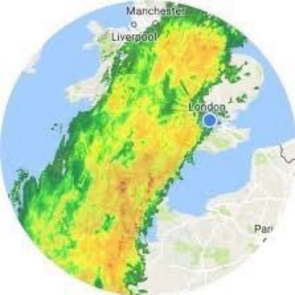
E.g. not far from me, radar estimates suggest up to 10 mm has fallen in the past 6 hours, while it's stayed totally dry here with some pleasant sunshine at times.
This situation feels like a prelude to spring, when such rainfall patterns become more common.

Today's weather setup in southern England & Wales features numerous areas of converging near-surface wind, leading to slow-moving areas of moist convection.
Result being a lot of rain in some places while others mere miles away see little to none.
So perhaps we're seeing a case of over confidence from ECMWF's ensemble, a trait I've noticed rather often in recent months.
So despite that model favouring mild & wet weather, at this time I'm leaning toward a cold & dry outcome for Wed-Thu in the UK & Ireland.


Unhelpfully, the ECMWF ensemble has played 'follow the leader' (i.e. det. run) with hardly any runs matching the 00z UKMO or GFS deterministic runs for Thu 19th.
Interestingly the AI version of ECMWF's ensemble is much more interested in a UKMO/GFS style outcome.


Judging by some forecast model runs, next Wed-Thu brings a chance of snowfall in southern UK.
However there is a wide spread of scenarios, from cold & dry to mild & wet, so that chance is looking rather small at this time.
This type of convective cell can become very powerful in the right conditions & is the most prone to produce tornadoes.
However, if vertical instability is weak (not much temperature drop with height), a long-duration but not very strong cell can occur, as we seem to see here.
Some context: In a strongly sheared environment i.e. where the wind speed &/or direction changes markedly with height, it is possible for a convective cell to sustain for a long time thanks to the area where air descends (downdraft) being displaced from the updraft.
13.02.2026 09:36 — 👍 0 🔁 0 💬 1 📌 0An interesting convective feature tracked between Swanage & the Solent this morning.
With the sustained core of very heavy rainfall & distinct outflow to the northeast, it has characteristics of a supercell (of a relatively weak variety - supercells don't always produce severe weather).

The GFS ensemble has become a bit more interested in a colder spell ~17th-19th Feb but it's hardly an emphatic signal.
This is a time where it would be extremely useful to know whether today's model shifts are a genuine trend or just a fluctuation. Anyone got a crystal ball?


Forecast modelling *might* be starting to converge on a colder, drier scenario for the UK & Ireland next week ~Wednesday onward, but it's a close call with the latest UKMO run, while GFS hasn't got there yet.
In short, the trend is favourable but rather flimsy at this stage.

A simple timeseries of the Oceanic Niño Index & Relative Oceanic Niño Index used by NOAA / CPC.
You can see just how much long-term warming has biased the ONI toward flagging more instances of El Niño (warm) & fewer of La Niña (cool).
The RONI addresses that very well.


See for example ECMWF's deterministic model (IFS) which has precipitation ceasing by the time the air has become cold enough to support snowfall to low elevations.
The high ground of Dartmoor may see a covering, perhaps the highest reaches of Exmoor too.


GFS is still suggesting that even lowland parts of southern England & Wales could see some falling snow tomorrow evening into the night, albeit not settling much.
However, in my experience the model tends to keep precipitation going too long when colder, drier air is mixing in.

The combined rainfall-sunshine view versus 2003-2025.
To someone who prefers plenty of dry weather & sunshine, 2026 is contesting 2021 for the title of 'bleakest start to a year's weather on record'.
I'm hoping this Saturday marks the start of a more varied run of weather.


For the year so far, again very mild nights on average (on par with 2002 for 5th highest, interestingly after a similarly cold start) & a lot of rain (comfortably 2nd wettest yet still well short of 2014!).
Despite a near-average January it's 3rd dullest sunshine-wise. Grim!


Local to me, Feb has so far been characterised by very mild nights (vying with 2024 for record highest mean daily min), a lot of rain (5th wettest), & not much sunshine (3rd dullest).
Reduced heating bills are the only upside to this from my personal perspective.

The UKMO run I don't have eyes on for beyond next Wednesday, but the setup it has for that day would likely force low pressure to head toward the Mediterranean, with cold & dry weather prevailing for northern Europe for at least a few days.
12.02.2026 10:00 — 👍 1 🔁 0 💬 0 📌 0

E.g. GFS goes on to slowly move a broad low north-eastward to encompass the UK & Ireland during Thu-Fri, whereas IFS (ECMWF's det. model) takes that same low into France as a smaller feature, with a ridge following on while cold air feeds across northern Europe from the NE.
12.02.2026 09:56 — 👍 1 🔁 0 💬 1 📌 0


Forecast confidence for northern Europe currently falls off a cliff from ~Wednesday.
The overnight det. runs from GFS, ECMWF, & UKMO all have markedly different situations for that time. Each would head in a distinct direction during the following few days.


FWIW the overnight ECMWF ensemble showed some interest in the mid-Atlantic/Greenland ridge idea, but it's far from emphatic.
Also there's a scenario where the Atlantic westerlies are only just strong enough to send the high toward Europe instead (dry & very mild weather in W).
The result being that a pattern of high pressure across south(western) Europe, low pressure further north, tends to emerge.
This winter, we instead have the polar vortex becoming weak again. Might that permit a pattern more typical of early in a La Niña winter? We'll soon see.
...with an increased propensity for cold spells to affect northern &/or western Europe.
Later in winter, the polar vortex is usually stronger, driving stronger westerlies across the North Atlantic which force those ridges to stay further south, often being 'stretched' eastward.
You see, from what I've read, La Niña's main effect on the N. Atlantic is to encourage more ridges of high pressure somewhere between the subtropical & polar latitudes.
In early winter, the polar vortex is often weak enough that these ridges can locate more toward polar lats...
Overall I find this setup pretty interesting because a propensity for an average to strong polar vortex state is AFAIK the main factor that makes La Niña winters tend to favour a +NAO with mild westerly type patterns affecting N. Europe in the 2nd half.
11.02.2026 14:04 — 👍 0 🔁 0 💬 1 📌 0Reason being, historical composites indicate that high pressure in the North Atlantic & across Greenland has often occurred in the wake of MJO phase 3 activity... but not always.
So it is that we see forecast models toying around with the idea of such but not committing to it.

...which means that an aligned surface weather pattern depends on events within the troposphere being conducive to building high pressure in the right general area.
By being active in phase 3, the MJO *might* encourage the required tropospheric behaviour.

...with any influence on surface weather pattern occurring 'off centre' relative to the high Arctic, meaning they don't show up well in the usual diagnostics.
Plus, such influence is not via a forced reversal of circulation, instead a weaker than usual cyclonic circulation...

If there is much influence, it will tend to encourage high pressure in the North Atlantic, the Canadian-side Arctic, & perhaps NW Pacific.
Complicating matters, this is not a large enough displacement to show up as a reversal of zonal mean flow at 60N in the N. Hemisphere...