INCREDIBLE footage from earlier this evening from the 43 Fire just southwest of Woodward, Oklahoma!
Absolutely INSANE firewhirls in the main fire line as it very quickly advanced northeast towards Woodward!
18.02.2026 01:50 — 👍 21 🔁 11 💬 0 📌 0

Got a nice, clear bolt this evening just before the tip-off for the OKC Thunder game in downtown!
#okwx
24.11.2025 00:42 — 👍 4 🔁 0 💬 0 📌 0

A view of the Northern Lights in southern Kansas during a strong solar storm on November 11th.
#kswx #northernlights
16.11.2025 16:30 — 👍 12 🔁 0 💬 0 📌 0

What I witnessed today doesn't even feel real, and the fact I got to spend it with some amazing people makes it that much better.
What an incredible show, never thought I'd see the northern lights like this in southern Kansas.
#kswx #okwx #northernlights
12.11.2025 08:46 — 👍 13 🔁 3 💬 0 📌 0


Another substorm is ongoing!!!! Absolutely INCREDIBLE views in southern Kansas! My goodness!
12.11.2025 04:59 — 👍 3 🔁 0 💬 1 📌 0

INCREDIBLE views of the northern lights ongoing in southern Kansas! Currently surging southward! This is incredible!!
#okwx #kswx
12.11.2025 03:16 — 👍 21 🔁 4 💬 0 📌 0

Quite rare to see this! A special marine warning has been issued on LAKE MICHIGAN for the potential of waterspouts within the snow bands on the south side of the lake!
#inwx #miwx
10.11.2025 18:27 — 👍 5 🔁 2 💬 0 📌 0

Alongside 6+ inches of snow falling in areas on the south side of Lake Michigan, it appears that there might even be waterspouts on-going in the snowbands on the SW side of Lake Michigan!
#ilwx #inwx
10.11.2025 06:33 — 👍 5 🔁 0 💬 0 📌 1
Made some upgrades for my Sony A7IV during prime day this week which includes a SmallRi camera cage, 2 side handles and a top handle!
Can’t wait for severe weather to come back!
10.10.2025 03:09 — 👍 3 🔁 0 💬 0 📌 0
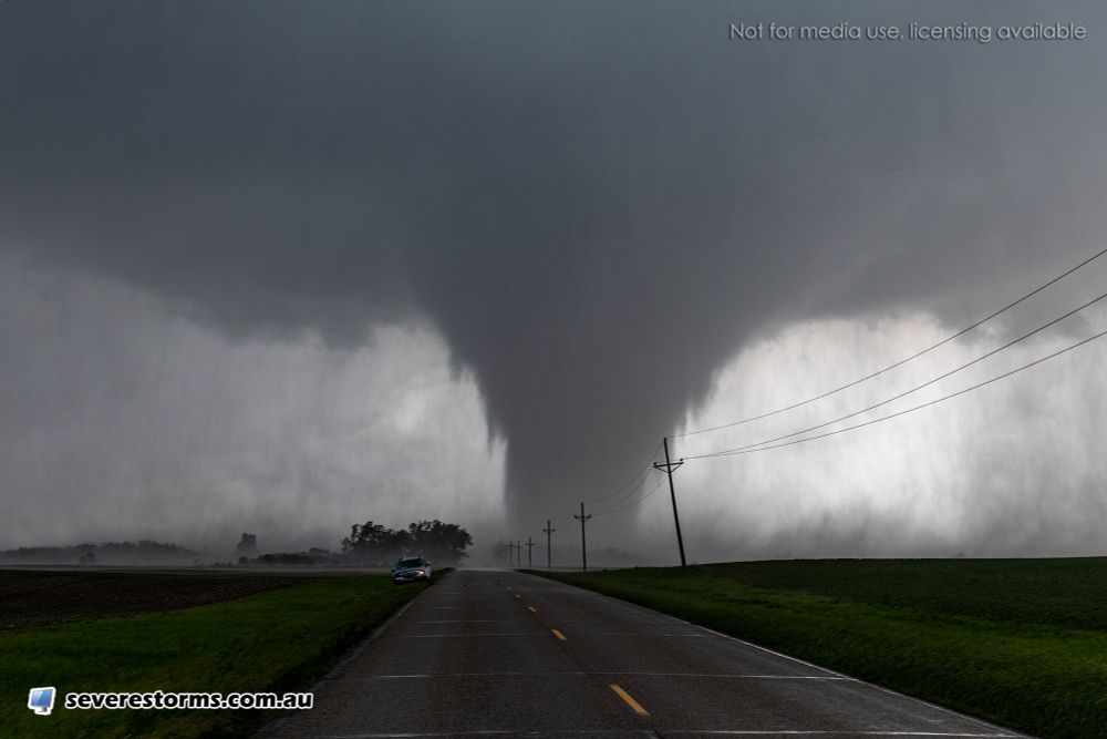
Close range video of the Arnett tornado as it was roping out a couple miles west of town
#okwx
27.06.2025 20:15 — 👍 6 🔁 0 💬 0 📌 0
New lakes are being created from storms dropping 1-2” of rain across parts of the OKC metro this evening!
#okwx
26.06.2025 23:25 — 👍 8 🔁 0 💬 0 📌 0
YouTube video by Charlie Kruschek
THE MEGA BARREL | Strong Tornadoes in North Dakota
Got a few minutes to spare? My first video from the Spiritwood, ND tornado is live over on YouTube!
youtu.be/g5DvMiKAQe0?...
22.06.2025 17:45 — 👍 15 🔁 4 💬 1 📌 0
Looks like you’re in a safe enough position Jason!
20.06.2025 02:17 — 👍 1 🔁 0 💬 0 📌 0

Current view of the supercell southeast of Lawton as it continues to mature
LIVE - www.youtube.com/live/JbFKY2R...
#okwx
18.06.2025 23:29 — 👍 6 🔁 1 💬 0 📌 0

Organizing wall cloud on the supercell east of Lawton, Oklahoma.
Continues to improve visually as the updraft base continues to widen.
LIVE - www.youtube.com/live/JbFKY2R...
#okwx
18.06.2025 22:26 — 👍 9 🔁 1 💬 0 📌 0

Going live as this storm continues to mature east of Lawton!
Link - www.youtube.com/live/JbFKY2R...
#okwx
18.06.2025 21:57 — 👍 2 🔁 0 💬 0 📌 0
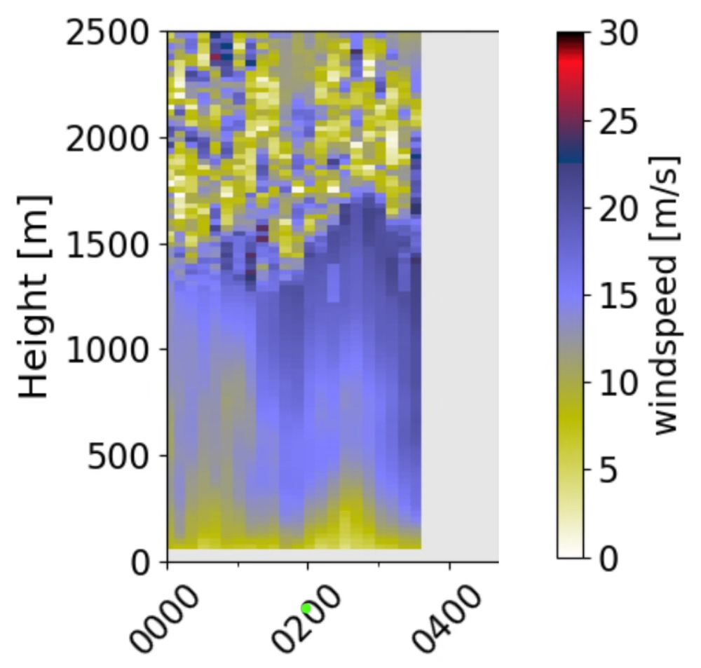
A time-height cross section shows wind speed data from the CLAMPS 2 Doppler lidar from 00 to just before 04 UTC. The formation of the low level jet is apparent.
CLAMPS2 lidar (at the NWC) winds show the low level jet picking up since 00UTC. As the outflow moves south toward Norman it’s neat to see convection initiation invigorate where presumably the LLJ is impinging on the outflow.
Watch CLAMPS data yourself: apps.nssl.noaa.gov/CLAMPS/data/...
18.06.2025 04:11 — 👍 5 🔁 2 💬 0 📌 0


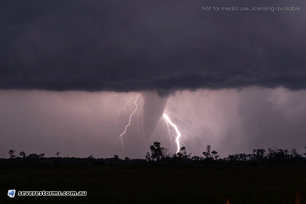
Dug out this extremely rain wrapped #tornado around 4:30 PM south of Harper, Kansas this evening.
Quite hard to see, but you can see the funnel coming down on the top left part of the image shortly before becoming a fully condensed cone tornado to our south.
#kswx
17.06.2025 23:33 — 👍 4 🔁 1 💬 0 📌 0

Large rotating wall cloud with clear slot south of Harper, Kansas
#kswx
17.06.2025 21:32 — 👍 8 🔁 3 💬 1 📌 0
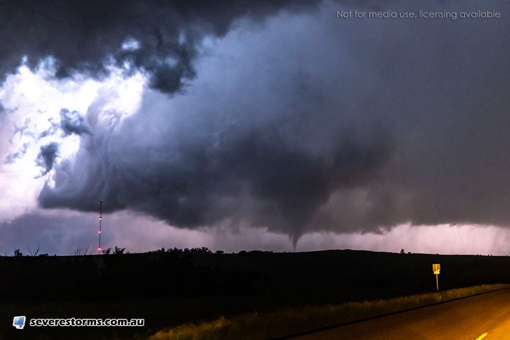
Brief tornado just occurred NW of Anthony, Kansas as a funnel rapidly came down and had a dirt circulation beneath it
LIVE - www.youtube.com/live/U5MHVws...
#kswx
17.06.2025 21:27 — 👍 9 🔁 1 💬 1 📌 0

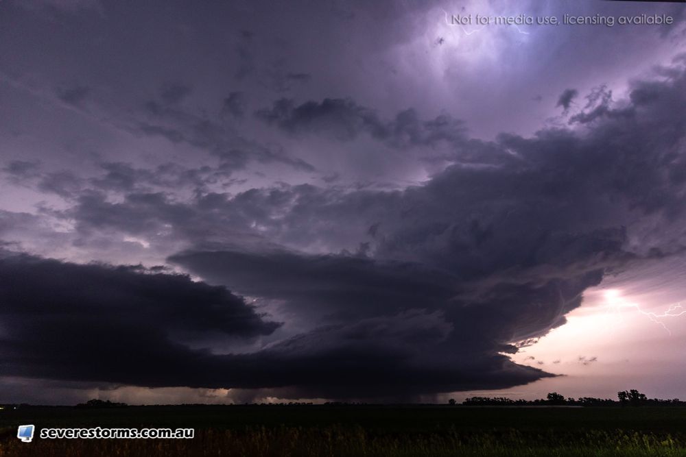
View of a large wall cloud with rotation northwest of Anthony, Kansas
#kswx
LIVE - www.youtube.com/live/U5MHVws...
17.06.2025 21:21 — 👍 7 🔁 2 💬 0 📌 0
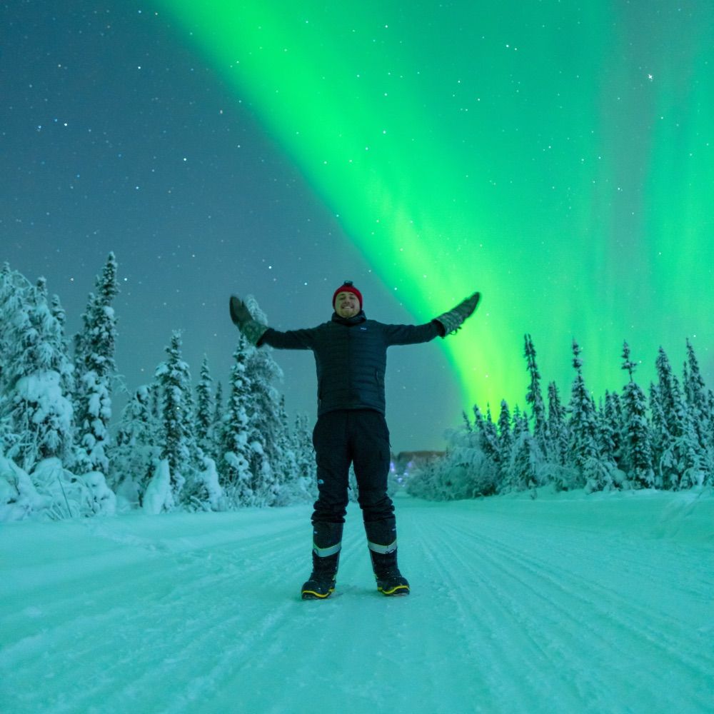
📷”The Aurora Guy”
🌌Space Physics Ph.D. student
📍North Pole, Alaska
🫂Participatory science, science comm.
🌀 Professional aurora chaser
👨💻Views my own
In-Situ Collaborative Experiment for the Collection of Hail In the Plains (ICECHIP). NSF funded field campaign to better understand all aspects of hail. https://icechip.niu.edu/
Sr. Hurricane Specialist at NHC 🌀 | Ph.D + M.S. via UAlbany & B.S. via UNCA | Enjoy all kinds of weather 🌤❄️⛈🌪| Thoughts are my own
Meteorologist 🏔
Opinions are my own and do not represent those of my employer
NWS meteorologist. Storm and scathing sarcasm enthusiast. Elbows up. Sic semper tyrannis
NWS Lead Meteorologist. Husband, father (x2), film critic. My posts are my own. BS/MS Meteorology from Iowa State University. Go Cyclones! 🌪 Go Hawks! 🐤
European Centre for Medium-Range Weather Forecasts
For press enquiries or for general queries to the Service Desk, please visit http://ecmwf.int/en/about/media-centre
NWS Meteorologist and Social Media Focal Point | NC ➡️ CA ☀️ | Experienced central CA's hottest month on record🫠 | Sometimes I post pictures I take of things
NOAA/NWS meteorologist at WPC. Millersville alum. Proud dad and husband. Maryland native. Baltimore sports fan.
Texas based photographer/storm chaser
Long distance drives with no destination to look at cool clouds is what I enjoy.
Official Bluesky account of the Oklahoma Mesonet. A joint project of the University of Oklahoma and Oklahoma State University providing 5-minute weather data from 120 stations across Oklahoma.
Photographer | Storm Chaser | Charlottesville, VA | PeterForisterPhoto.com
Atmospheric Scientist (via CSUx2 & UGA). Enjoyer of ⛈️❄️🐱🏔️🏃♀️
(personal account)
• Long Island native Michael Koch
• Storm chasing veteran of 20+ years
• Studied meteorology at SUNY Oswego
• Hurricane Gloria was my first love…
Photographer, Storm Chaser and Dog Mom. MelanieMetzStormChasing.com.
Digital Meteorologist | Severe Weather Broadcaster | The Internet's Weather Man |
Providing daily forecast updates & to-the-minute severe weather info for Southern Middle Tennessee, Northwest Alabama, and Northeast Mississippi.
www.tnvalleyweather.com #tnvalleyweather #alwx #tnwx #mswx
CEO of Bluesky, steward of AT Protocol.
dec/acc 🌱 🪴 🌳
Certified Broadcast Meteorologist @FOX8NOLA
Former: @CNN @KSWO7NEWS @KKTV11News
@ou_meteorology Alum | Boomer Sooner | Who Dat ⚜️
📡 Research meteorologist.
🌇 Politics, urbanism, and tech on the side.
📍 NYC --> OKC.
🏳️🌈 Opinions are my own.