One of the primary tools we use to predict flash floods is the NSSL's Multi-Radar/Multi-Sensor System. "I’ve zero doubt NWS forecasters were leveraging that tool that evening to issue flash flood warnings. NSSL and associated projects are slated for elimination in NOAA’s proposed 2026 budget."
07.07.2025 14:11 — 👍 69 🔁 27 💬 0 📌 0

Add all these factors together, combined with the strong MCV and you get a massive Rear Inflow Jet, with exceptional sustained winds and gusts at the surface extending over 100 miles.
tl;dr:
Wake low? No, but close
Mesoscale Convective Vortex with top tier Rear Inflow Jet? Yes.
21.06.2025 20:24 — 👍 5 🔁 0 💬 1 📌 0

Looking at our sounding (this time from Aberdeen), we have a crap ton of all 3.
1. High dew-points, to nearly 700mb. With a mean liquid ratio of 16.3 g/kg (!!)
2. A boatload of CAPE (5000 j/kg) with exceptional mid-level lapse rates.
3. RH in the mid/upper regions below 30%
21.06.2025 20:24 — 👍 4 🔁 0 💬 1 📌 0

What drives an RIJ is latent heat release. Evaporation of water. That evaporation drives descending winds from aloft to the surface. So what do we need to turbocharge our RIJ potential?
1. Water
2. A way for water to get up there (ie. CAPE).
3. A way to evaporate it quickly.
21.06.2025 20:24 — 👍 4 🔁 0 💬 1 📌 0

Okay, so let's look at the Bulk Shear from BIS 00z Balloon last night and holy sh*t we've got westerly 100kts at 250mb and 25kts easterlies at 850mb. That's 125 kts of relevant bulk shear. This RIJ development could be MASSIVE. But an RIJ takes more than just shear.
21.06.2025 20:24 — 👍 4 🔁 0 💬 1 📌 0

MCV's aren't uncommon but what really kicked it into overdrive was a very strong Rear Inflow Jet (RIJ). In particular a descending RIJ. Decending RIJ's are more prevalent in high storm relative shear environments. You can effectively simplify this as Surface to some high altitude
21.06.2025 20:24 — 👍 5 🔁 0 💬 1 📌 0

So what did happen in ND last night? Well, it was likely a combination of two (strong) interlinked phenomena.
1st is the development of an asymmetric Mesoscale Convective System (MCS) leading to a strong Mesoscale Convective Vortex (MCV) / Bookend vortex.
(Fig b.)
21.06.2025 20:24 — 👍 5 🔁 0 💬 1 📌 0

Wake low's are associated with a rear inflow jet that does not make it to the surface however induces pressure perturbations that drive a low pressure "rebound" near the surface. Air from the mesohigh near the squall line moves backward to the wake low. Usually Easterly winds.
21.06.2025 20:24 — 👍 5 🔁 0 💬 1 📌 0

Wake low's are technically associated with winds from the front of the squall line to the back. They are most commonly associated with strong easterly winds (in a westward moving MCS) behind the storm, and are prevalent in stable environments (ie. Elevated Convection).
21.06.2025 20:24 — 👍 6 🔁 0 💬 1 📌 0
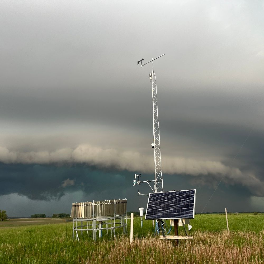
Below is a series of posts explaining the difference between a wake low and a Mesoscale Convective Vortex (MCV) and a Rear Inflow Jet (RIJ) and how this exceptional storm system over North Dakota came to be last night. This radar loop is awesome by the way.
21.06.2025 20:24 — 👍 37 🔁 10 💬 1 📌 0
Here is the launch via GOES-16. Didn't notice any clear signature down-range in southwest atlantic. Looked at Key West, Puerto Rico, and the few cuban radars as well and nothing.
16.01.2025 23:33 — 👍 0 🔁 0 💬 0 📌 0

RadarScope/colortables at main · wxmeddler/RadarScope
Custom Color Tables and Other Things for Radarscope - wxmeddler/RadarScope
Do you use @radarscope.bsky.social and have a Tier 1 or 2 subscription? I made some custom color tables you can download and import.
github.com/wxmeddler/Ra...
28.11.2024 04:19 — 👍 4 🔁 0 💬 1 📌 0
I've personally seen everything from cottonwood seeds, to sleet / graupel, dust (obviously), heavy smoke, cause this phenomenon. Poor onboard instrument quality control / error detection is really ruining the wind climatology of locations with sonic anemometers.
18.05.2024 02:15 — 👍 2 🔁 0 💬 0 📌 0

As part of my 2017 Masters Thesis when I surveyed NWA meteorologists about hurricane forecasting. I asked about the cone's fixed size (see attached image):
43.5% Yes, it's fixed size no matter the storm
43.9% No, it changes
12.5% Not sure
N was 255.
10.04.2024 14:44 — 👍 1 🔁 2 💬 1 📌 0
Meteorologist living & working in Colorado and Wyoming. Hobby photographer, mountaineer, trail runner & storm chaser.🌪 📸 🏔🏃♂️
The biggest collection of storm chase events on the web. For storm chasers, by storm chasers.
Space, software, occasional politics, and bird photos! Software engineer, working on rockets, spacecraft, and things that make fire and loud noises.
Currently: Flight software at Stoke Space. Formerly: APL/Dragonfly, Blue Origin/New Shepard+BE-3, Shuttle
Sr. Hurricane Specialist at NHC 🌀 | Ph.D + M.S. via UAlbany & B.S. via UNCA | Enjoy all kinds of weather 🌤❄️⛈🌪| Thoughts are my own
🌦 North Dakota's Weather & Climate Resource
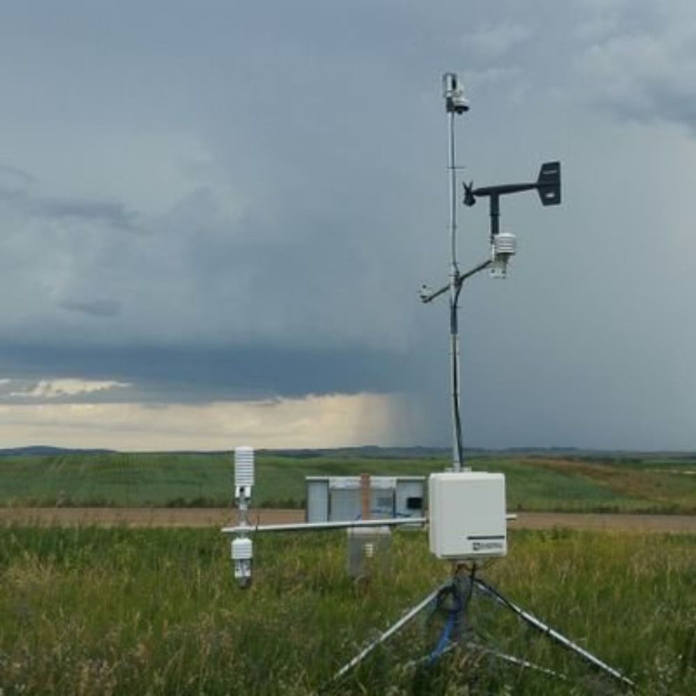
★ ND Agricultural Weather Network, the official mesonet of ND with 245 research-grade weather stations (ndawn.info)
★ ND State Climate Office, the official climate resource of ND (https://www.ndsu.edu/ndsco/)
🦬 NoDak 🌾
Meteorologist ⛈️ Environmental Scientist
Mesonet technician 〰️ NDAWN
Climatologist 〰️ ND State Climate Office
I 🤍 cats
Professional (not hobbyist) Chasing Team of REDACTEDS. Tweets do not reflect opinion of employers.
Someone who studied the weather
University of Wisconsin AOS 🇨🇦🇺🇸
Meteorologist and research associate @ OU CAPS | M.S. OU '20 | B.S. UBC '18. Severe wx/music nut and contributor for US Tornadoes and Tornado Archive. Opinions my own.
Senior Producer, FOX Weather⚡️NYC
Meteorologist/GIS // NC State MGIST '23 // UNCA ATMS '17 // Photographer // Deaf w/ Cochlear Implant // SC, NC, MO, NH //
storm chaser, time lapser, video editor, likes unwatchable films, makes unwatchable youtubes, www.wxlog.com
Interested in all things weather! | Bixby, Oklahoma | Production Assistant for KOKI-TV FOX23 News | Contributor for @tornadoarchive.com | All opinions are mine, and mine alone.
24 Y/o Photographer and Storm Chaser based in Fort Collins, Colorado.
#wxsky #weather #photography #wxbluesky
Photographer 📷 🌠 & Storm Chaser 🌪️⚡. Contact me to license footage.
Senior Weather Observer for KDTW, CMU Grad 2008, Lover of severe weather, blizzards, and standup comedy. Huge Detroit Tigers fan. Dan Campbell is my spirit 🦁
Studying supercell dynamics and predictability | PhD Student @ OU - MS Texas Tech - BS Northern Illinois
MIllersville University. Obsessed with science. Chronic nerd.