Graphic with a red-to-purple gradient overlay showing a hand signing a printed document. Large white text reads ‘We’re Hiring!’ and a URL at the bottom reads ‘earthscope.org/careers’.
We’re hiring! EarthScope is looking for a Contracts Administrator II (remote, US) to coordinate contract and award administration across the organization.
Learn more & apply: https://earthscope.org/careers
02.08.2025 09:02 — 👍 1 🔁 3 💬 0 📌 0
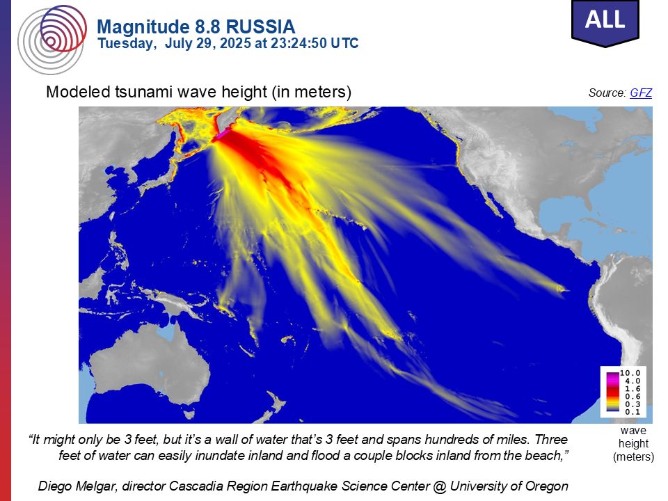
Map showing modeled tsunami wave heights across the Pacific Ocean following a magnitude 8.8 earthquake off the coast of Russia’s Kamchatka Peninsula on July 29, 2025. Wave energy radiates outward from the source toward Japan, Hawaii, the U.S. West Coast, and other Pacific regions. A quote from Diego Melgar emphasizes the danger of even small tsunami wave heights
Recent Earthquake Teachable Moment for the magnitude 8.8 earthquake near Petropavlovsk-Kamchatsky, Russia
Teachable Moments presentations capture the opportunity to bring knowledge, insight, and critical thinking to the classroom following a newsworthy earthquake.
➡️ https://loom.ly/6Eo_fYc
01.08.2025 17:30 — 👍 23 🔁 5 💬 1 📌 0
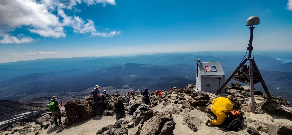
landscape photo of the workers scatter around on rocks, and a man in yellow working on a large instrument on the right. The foreground consists of brown and gray gravel and rocks, with people scattered among them. the right side of the picture has a large metal gray box, and an instrument sitting on a tripod. A man in yellow in crouching down near the base of the instrument working on it. the background consists of rolling blue mountains, with a bright blue sky above and a cloud in the right side of the sky.
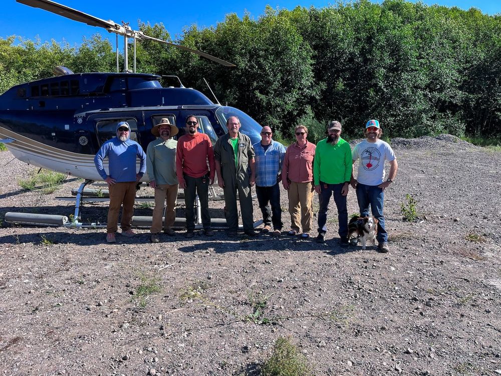
group of field workers stand together smiling with helicopter behind them. It sits on gravel and rock with bushy green trees filling the background and a small amount of clear blue sky peaking through the top.
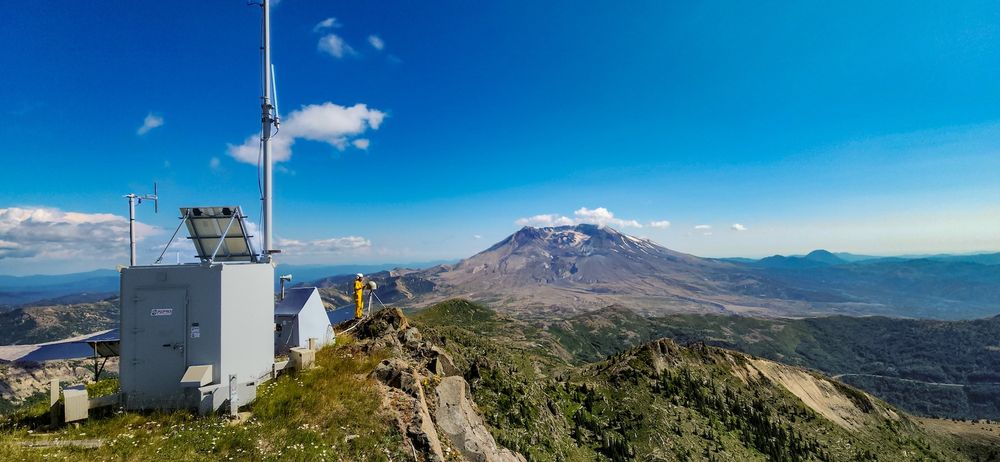
landscape photo of instrument and mount St Helen. On the left a large metal box with antenna and a solar panel sits, with a person in yellow working on an instrument to the right and a bit further back. To the right of that sits the volcano and its surrounding landscape. There is a bright blue sky above, with a few scattered clouds along the horizon and on the left side.
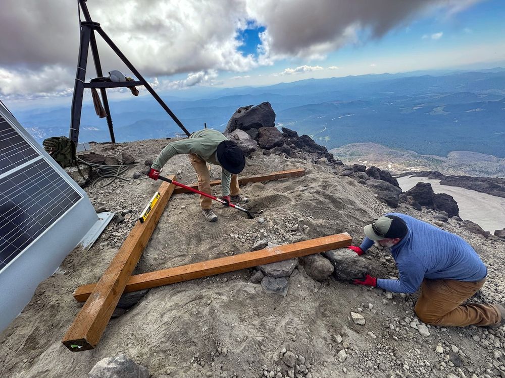
workers installing a platform for instruments on a brown and gray rocky surface. 3 wooden beams making 3 sides of a square are laying on the ground, with one worker placing rocks beneath a beam and the other digging a hole in the ground in the middle. to the left of them sits a large solar panel, and in the back left of the image sits an instrument on a tripod. in the background are rolling blue mountains, with large clouds filling most of the sky.
Mount St. Helens doesn’t take winters lightly, so our team took winter prep to new heights, flying in by helicopter to service our instruments.
One station is on Google Maps, so if you’re hiking by check us out and leave a 5-star review 🤓
📍EarthScope Observatory Station, Cougar WA
#fieldworkfriday
01.08.2025 10:04 — 👍 10 🔁 1 💬 0 📌 0

intern stands in center of frame facing the camera and smiling. behind her is green foliage.
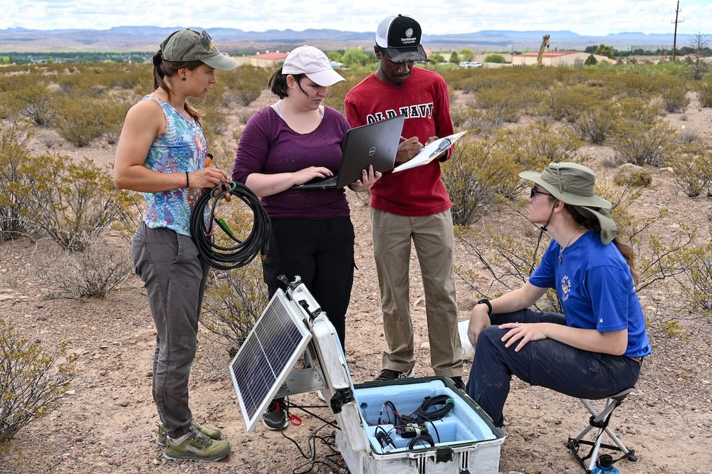
group of 4 interns working in a desert field covered or short shrubs with mountains off in the distance. intern on the left is is holding cables, while one in the middle holds a computer open and the other holds a clipboard while writing on it. The intern on the right is seated in a short stool with a metal box of equipment at their feet.
Meet Rebecca, one of the RESESS summer interns! She is working on how machine learning can be applied to study the interior of magma chambers. Learn more about the work Rebecca does in her interview: https://loom.ly/fzW32cQ
31.07.2025 13:02 — 👍 5 🔁 0 💬 0 📌 0
On Tuesday, an 8.8 magnitude #earthquake struck off the coast of Russia, triggering multiple #tsunami alerts along the U.S. west coast. Learn how NOAA scientists monitor, detect, and research tsunamis: noaa.gov/explainers/science-behind-tsunamis
31.07.2025 16:23 — 👍 290 🔁 98 💬 9 📌 12
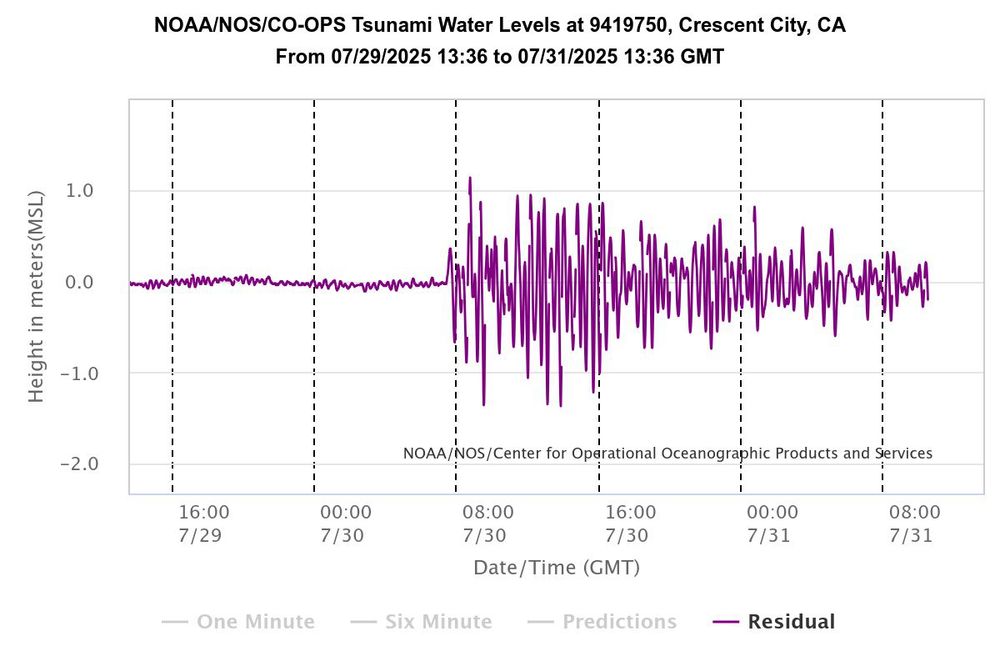
Crescent city river gauge record
Just to illustrate how long waves from a #tsunami can keep going, this is a tide gauge record from Crescent City CA (known for its sensitivity to tsunami waves due to bathymetric and resonance effects) showing significant wave activity still continues 24+ hours after their first arrival. 🧪⚒️
31.07.2025 10:41 — 👍 75 🔁 29 💬 3 📌 4
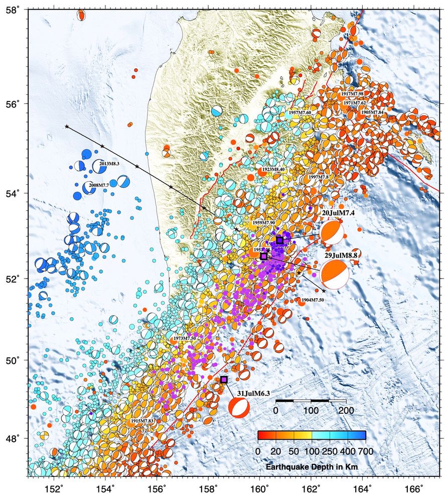
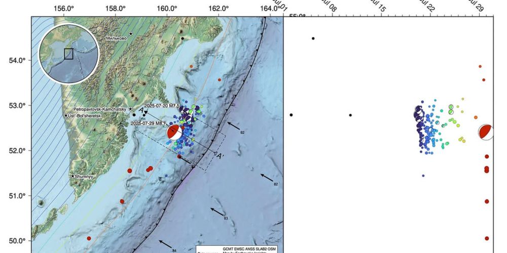
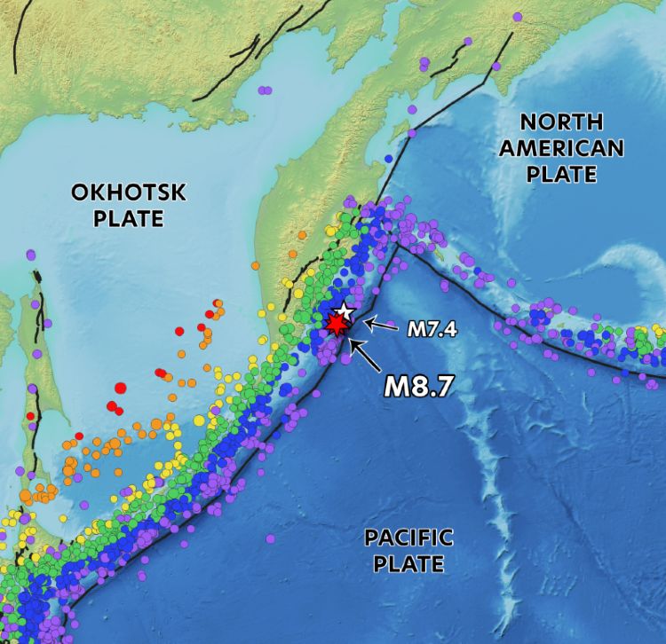
Map of seismicity with pink circles aftershocks of the M8.8 and the purple circles after shocks of the M7.4 foreshock
Aftershocks from the M8.8 Kamchatka #earthquake will likely continue for years. This sequence now also includes tensional events in the outer rise area, where the subducting slab bends to dive into the mantle. 🧪⚒️
31.07.2025 11:05 — 👍 55 🔁 16 💬 1 📌 1
A look at the July 29th magnitude 8.8 subduction zone earthquake near Kamchatka and the tsunami it triggered.
30.07.2025 16:10 — 👍 12 🔁 6 💬 1 📌 1
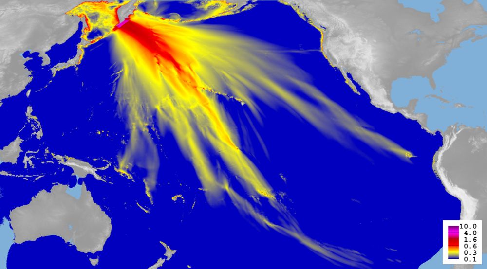
Modelling results for the #Kamchatka tsunami from July 30, 2025. Pacific ocean in dark blue, red and yellow colors show the wave heights. In grey, the land masses of Eurasia (upper left), Australia (lower left) and the Americas (right).
Fresh from the press, so to speak, a result of our #tsunami model based on the specifics of this earthquake (we will update it one we have more model runs). The color code is wave height in metres. The dotted line in the centre of the picture is the Hawaiian island chain.
30.07.2025 15:44 — 👍 102 🔁 40 💬 2 📌 11
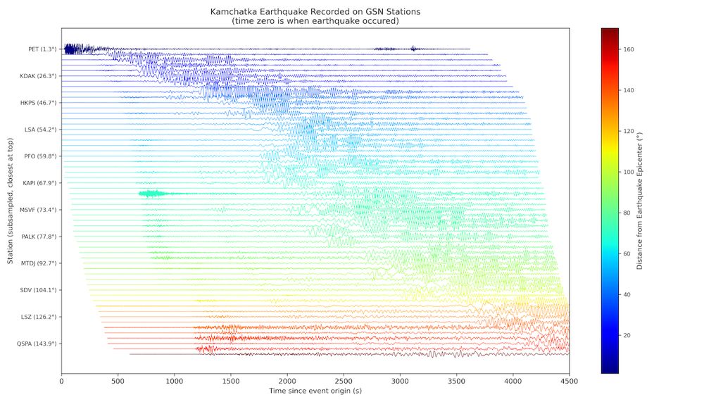
A tall rectangular plot showing 115 horizontal wiggle traces stacked vertically, each trace normalized and offset so that the closest station is at the top. The x‑axis runs from 0 to 3500 s (“Time since event origin (s)“), and the y‑axis labels every fifth station with its network code and epicentral distance in degrees (e.g. “ABCD (12.3°)“). Each trace is colored according to its distance from the epicenter using a jet colormap (cool blue for nearby, warm red for distant). A vertical colorbar at right indicates epicentral distance from 0° to ~180°. The title reads “Kamchatka Earthquake Recorded on Subsampled GSN Stations (Aligned to Origin Time).”
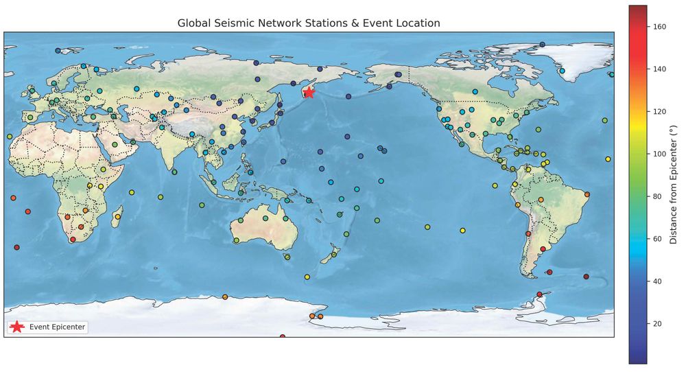
A wide rectangular globe view in Plate Carrée projection, recentered so longitude 160° E is in the middle. The map displays a shaded‑relief background of Earth’s landmasses and oceans. Thin gray coastlines and dotted political borders overlay the relief. Black‑edged circles mark 230 seismic stations, colored by epicentral distance using the MATLAB‑style “jet” rainbow colormap (blue through yellow to red). A large red star at 54° N, 160° E marks the earthquake epicenter. A vertical colorbar at right labels “Epicentral Distance (°)” from minimum to maximum. The title reads “Global Seismic Network Stations & Event Location (Centered on Epicenter with Topography).”
From earthquake epicenter to Antarctica, Global Seismic Network stations picked up the Mw 8.8 Kamchatka earthquake.
At the link, click the Technical tab on the right, then SAGE data access on the bottom, and you can see the GSN and download these waveforms for yourself!
https://loom.ly/6Eo_fYc
30.07.2025 11:45 — 👍 4 🔁 0 💬 0 📌 0
NEW: You may wonder why Japan’s 2011 mag-9.1 quake created a colossal tsunami that killed 18,000 people, while today’s mag-8.8 quake made a big, but not catastrophic, tsunami.
For @sciam.bsky.social, I explore why. (Hint: it’s because the 2011 quake was SO much stronger.)
30.07.2025 17:19 — 👍 49 🔁 23 💬 3 📌 1
More fascinating ways the M8.8 Kamchatka earthquake has been recorded! Did you know that even earthquakes thousands of miles away can cause changes in groundwater levels?
www.usgs.gov/mission-area...
30.07.2025 17:27 — 👍 22 🔁 11 💬 0 📌 1
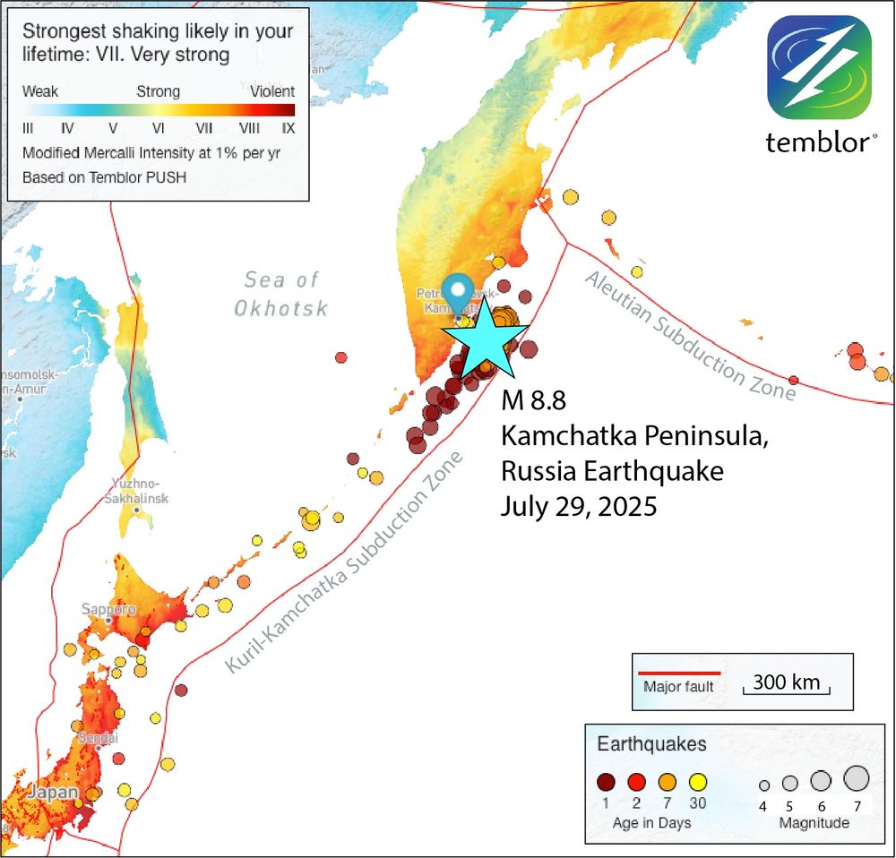
Temblor map of the M 8.8 Kamchatka Peninsula earthquake. The peninsula and other land is color coded according to shaking expected in your lifetime, per Temblor's PUSH model. The mainshock is marked by a bright blue star. Smaller quakes are marked by circles that scale with magnitude and are color coded by age in days. Credit: Temblor
Around 11:30 am local time, a magnitude 8.8 earthquake struck the offshore Kamchatka region at a depth of about 20 kilometers. The subduction zone quake caused severe shaking on the Kamchatka peninsula and triggered tsunami warnings and advisories around the Pacific. (1/n)
30.07.2025 07:37 — 👍 33 🔁 15 💬 1 📌 1
Watch how seismometers recorded the passing earthquake waves from the magnitude 8.8 earthquake off Russia’s Kamchatka Peninsula.
Each dot in this animation is a seismic station—red 🔴 means the ground moved up, blue 🔵 means it moved down.
More ➡️ https://loom.ly/6Eo_fYc
30.07.2025 05:58 — 👍 76 🔁 45 💬 0 📌 7

NISAR Launch
Join NASA and ISRO (the Indian Space Research Organisation) for the launch of our most advanced Earth-observing radar satellite, which will provide 3D views ...
🚀🛰️ Live coverage of the #NISAR launch is underway!
Tuning in to NASA's live stream? Share your reactions here with us! What scientific questions are you hoping to explore with NISAR data?
https://loom.ly/X2PPHcs
30.07.2025 04:01 — 👍 1 🔁 1 💬 0 📌 0
M8.8 earthquake strikes offshore Kamchatka
A dangerous subduction megathrust ruptures once again
⚒️ 🧪
A M8.8 earthquake just ruptured the subduction zone offshore Russia’s Kamchatka peninsula. This is one of the world’s truly huge earthquakes, and a triggered tsunami is currently traveling across the Pacific ocean.
This same fault ruptured on July 20th in a M7.4, and last August in a M7.1.
30.07.2025 04:05 — 👍 177 🔁 92 💬 2 📌 9
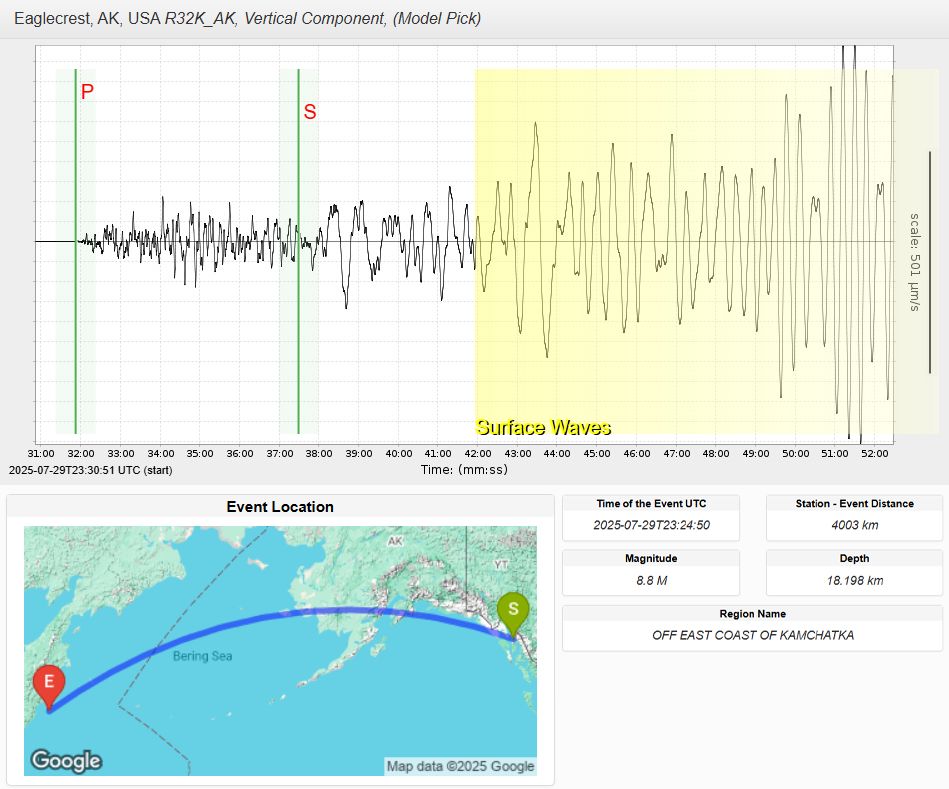
Seismogram and map from Station Monitor showing vertical ground motion from the July 29, 2025 magnitude 8.8 earthquake off Kamchatka. The seismogram was recorded at station R32K in Eaglecrest, Alaska, and marks the arrival of P waves, S waves, and surface waves. A yellow highlight shows the surface wave portion of the signal. The map below shows the path between the event epicenter off Kamchatka (marked “E”) and the station in Alaska (marked “S”), spanning 4003 km.
The magnitude 8.8 earthquake off Russia’s Kamchatka Peninsula is tied for the 6th largest ever recorded by modern instruments.
Check out how the ground moved near you using our Station Monitor app
⬇️
https://loom.ly/LvUPs2g
29.07.2025 21:05 — 👍 33 🔁 19 💬 0 📌 3
🧪⚒️ Notice how newer updates about the Kamchatka quake say M8.8, though it was M8.7 earlier?
That doesn't mean something changed about the quake - it just means people were able to consider more data in the magnitude calculation.
This kind of revision happens a lot, especially for bigger quakes.
30.07.2025 02:46 — 👍 129 🔁 17 💬 0 📌 0

U.S. Tsunami Warning Centers
TSUNAMI WARNING 3: See tsunami.gov for alert areas. M8.7 080mi SE Petropavlovsk, Kamchatka 1625PDT Jul 29
30.07.2025 01:36 — 👍 178 🔁 103 💬 7 📌 18
Subduction zone earthquakes don’t just shake the ground, they also displace the seafloor, which can trigger tsunamis that travel vast distances across the ocean. Earthquakes like this highlight the importance of global seismic and tsunami monitoring systems.
30.07.2025 01:19 — 👍 10 🔁 1 💬 0 📌 0
At the Kuril-Kamchatka Trench, the Pacific Plate subducts beneath the Okhotsk Plate, producing frequent moderate to large earthquakes—like the recent magnitude 7.4 event on July 20.
30.07.2025 01:19 — 👍 8 🔁 1 💬 1 📌 0
Map showing the tectonic setting of the Kamchatka Peninsula region. The Pacific Plate subducts beneath the Okhotsk Plate at the Kuril-Kamchatka Trench. A red star marks the epicenter of the July 29 magnitude 8.7 earthquake offshore, with a nearby white star indicating the earlier July 20 magnitude 7.4 earthquake. Colored dots along the plate boundaries represent historical earthquakes, with different colors denoting earthquake depth. Plate boundaries and labels for the Pacific, Okhotsk, and North American Plates are also shown.
How often do magnitude 8+ earthquakes occur? Not very often. While the last one occurred in 2021, on average, Earth experiences about one M8 earthquake per year.
Today’s M8.7 earthquake off Russia’s Kamchatka Peninsula is a powerful example of a megathrust earthquake along a subduction zone.
29.07.2025 18:19 — 👍 36 🔁 12 💬 1 📌 4
A magnitude 8.7 earthquake has just occurred off Russia's Kamchatka Peninsula, just a bit over a week after a magnitude 7.4 earthquake in the same area.
Multiple tsunami warnings and advisories are in place. Please check www.tsunami.gov for the latest information.
30.07.2025 00:37 — 👍 29 🔁 15 💬 0 📌 3
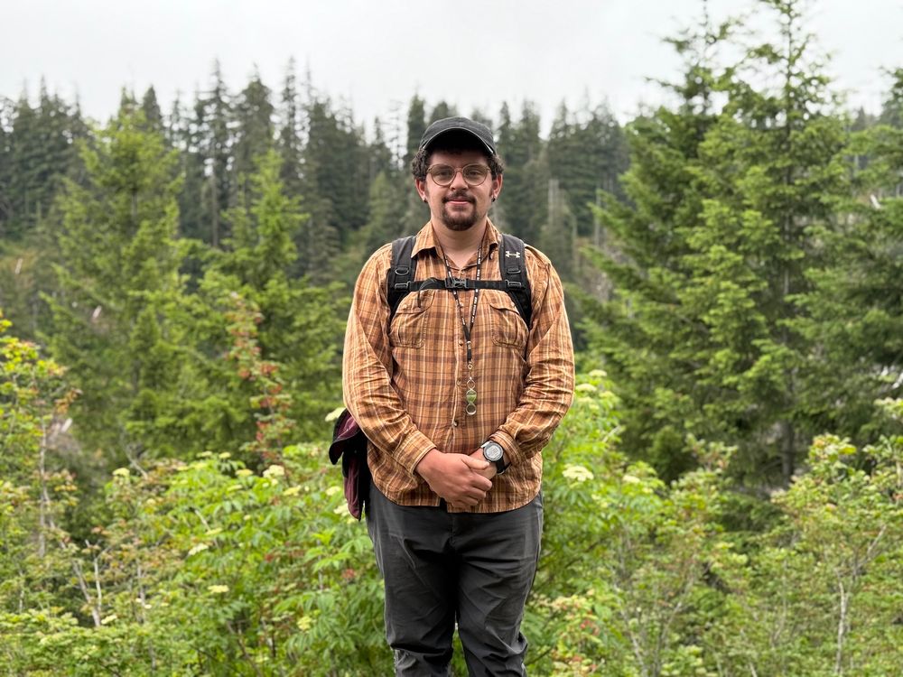
intern stands in middle of photo smiling in an orange plaid shirt with a backpack on. thick green foliage surrounds the background, with a hazy gray sky above.
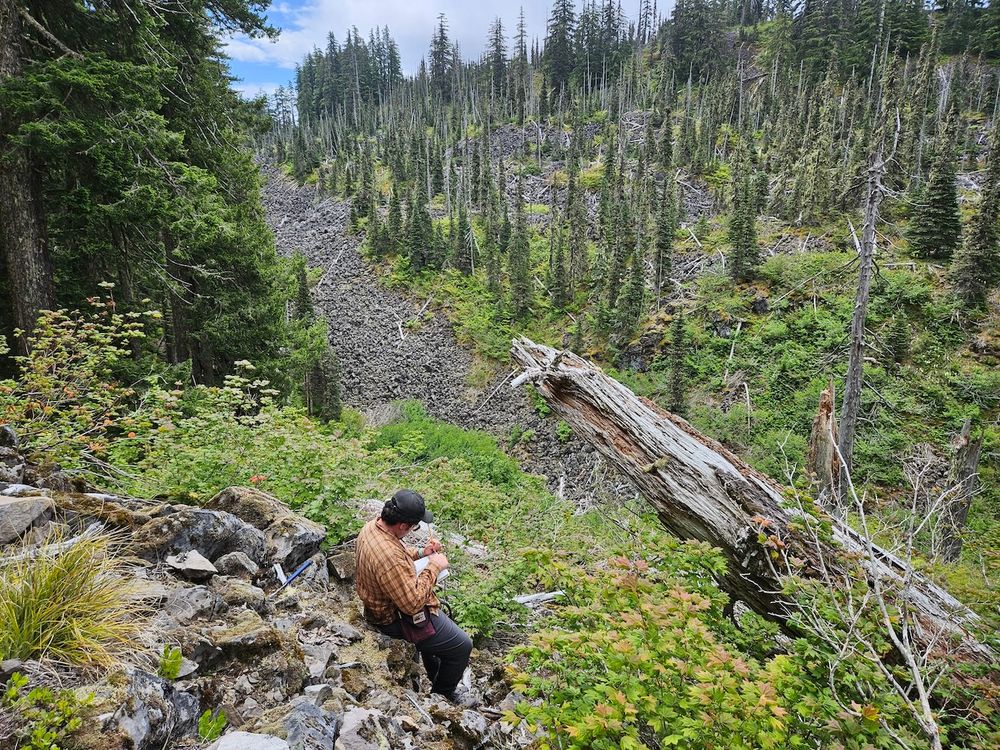
interns stands facing the right side of the screen, leaning against a pile of rocks while holding a notebook in left and writing with a pen in right. a rocky pile sits in the lower left corner of the frame, with a dead log sticking out from the lower right corner and scattered trees an a hill throughout the background.
Meet James, one of the RESESS summer interns! He is studying the magma storage conditions of prior eruptions at an understudied and potentially active distributed volcano. Learn more about the work James does in his interview: https://loom.ly/OkVmOS8
29.07.2025 12:30 — 👍 2 🔁 1 💬 0 📌 0
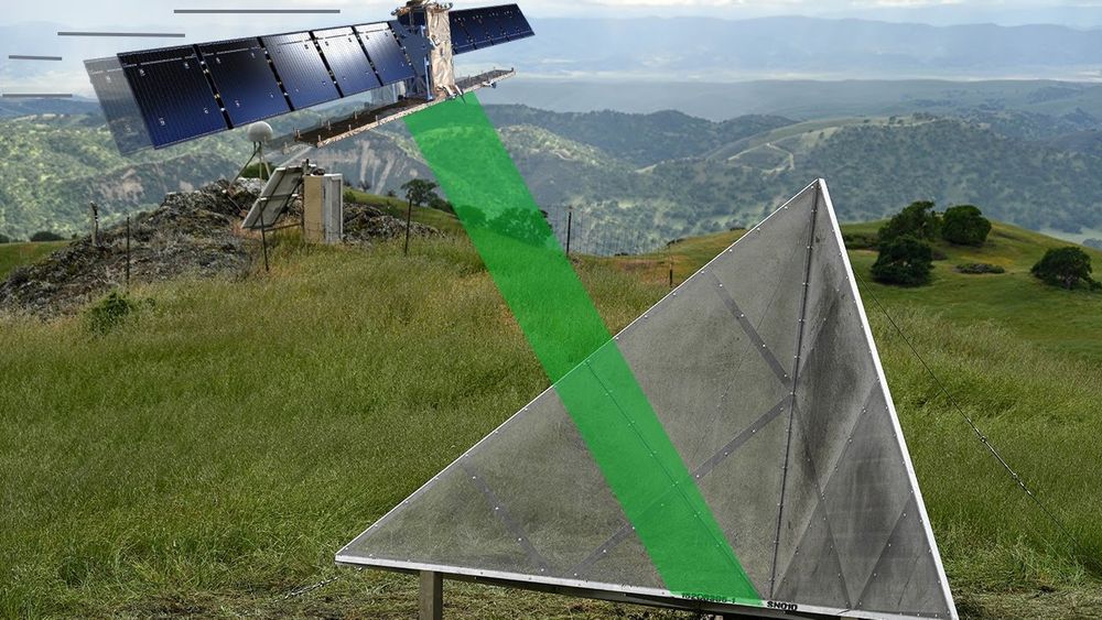
A silver, triangular corner reflector stands in a grassy field beneath a stylized satellite in orbit. A green radar beam connects the satellite to the reflector, illustrating signal reflection. Rolling hills and mountains appear in the background.
🛰️ The #NISAR (NASA-ISRO Synthetic Aperture Radar) mission is set to launch tomorrow!
Ahead of liftoff, we’re spotlighting how EarthScope-supported corner reflectors will help calibrate satellite radar data from NISAR and other satellite missions.
Watch here 📽️ https://loom.ly/KCy6Ffc
29.07.2025 07:25 — 👍 6 🔁 3 💬 0 📌 0
On December 26, 2004, a magnitude 9.1 earthquake ruptured the Sunda subduction zone north of Sumatra. The earthquake ruptured northward for nearly 10 minutes, causing a maximum displacement of over 20 m and producing a tsunami that swept across the Indian Ocean basin.
28.07.2025 12:02 — 👍 6 🔁 4 💬 1 📌 0
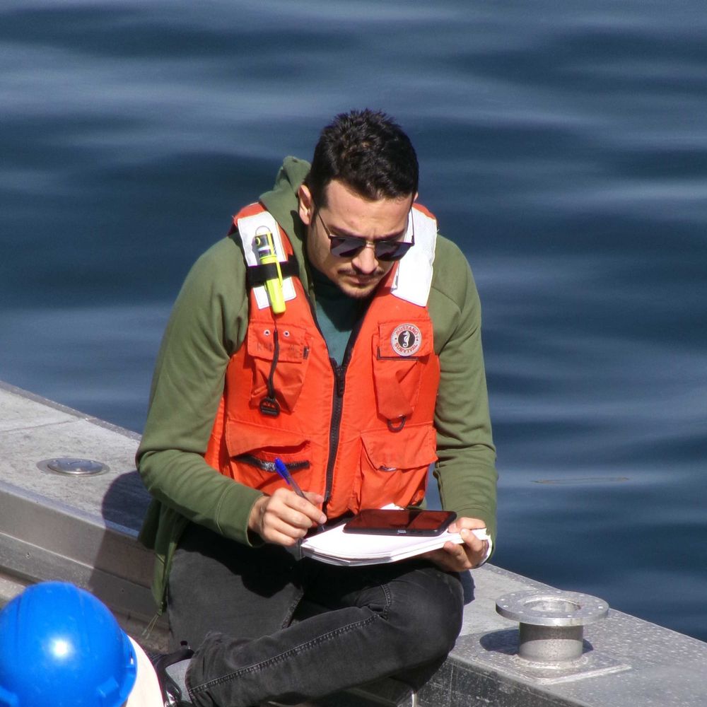
intern conducting field work at sea, sitting on the edge of a boat with a lifejacket on and the sea in the background. He is holding a pen in his right hand and papers in his lap, writing down information.
Meet Erfan, an intern from the student career intern program! He is is a Ph.D. student in Oceanography at the University of Washington, specializing in underwater acoustics and Distributed Acoustic Sensing (DAS). Learn more about the work Erfan does in his interview: https://loom.ly/L9pMsh4
25.07.2025 12:30 — 👍 8 🔁 1 💬 1 📌 0
Seismic waves race through Earth’s interior 🏁 They zoom through cold, rigid material and crawl through hot, soft zones. What does the journey from earthquake to receiver look like for a seismic wave? Find out on the new Seismology page of our "What is geophysics?" section ➡ https://loom.ly/LlGzbB0
24.07.2025 12:30 — 👍 5 🔁 1 💬 0 📌 0
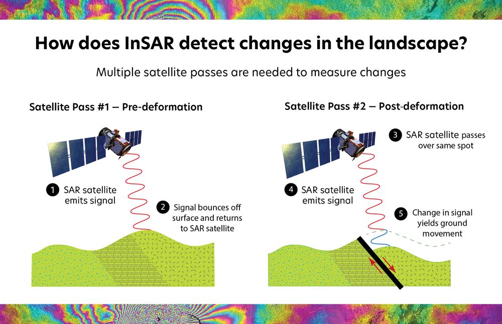
Infographic explaining how InSAR detects landscape changes by comparing two radar satellite passes—before and after surface deformation. A radar signal is emitted and reflected from the ground during each pass; changes in signal phase between passes reveal ground movement. Background and bottom border show rainbow-colored interferograms.
🌍🛰️ The countdown is on, just one week until the launch of #NISAR, a joint NASA-ISRO Synthetic Aperture Radar (SAR) satellite mission that will revolutionize global studies of Earth's surface.
Curious how we use satellites to study Earth? Learn more about InSAR ⬇️
https://loom.ly/XFSYdY8
23.07.2025 08:05 — 👍 7 🔁 5 💬 0 📌 1
Official account of the International Association of Geodesy #IAG and its Global Geodetic Observing System #GGOS.
Explore the #Science of #Geodesy: Measuring #Earth 's #shape, #gravity, and #rotation for a sustainable future.
The Geological Society of London is the oldest geological society in the world, and the UK's learned and professional body for Earth & Planetary scientists with ~12,000 members worldwide. www.geolsoc.org.uk
Cutting-edge research, news, commentary, and visuals from the Science family of journals. https://www.science.org
Using science, technology, and community engagement to understand, detect, and mitigate multi-hazards in the Pacific Northwest.
Official site of the Washington Emergency Management Division. Content Guidelines: https://mil.wa.gov/social Not here 24/7 #wawx #EMGchat
Preparedness tips: https://mil.wa.gov/preparednes
Alerts: https://mil.wa.gov/alerts
Join the largest #CitizenScience #earthquake network with your #seismograph. Mobile App: #ShakeNet. Discord Server: http://raspberryshake.org/discord
The University of Utah Seismograph Stations (UUSS) is a research, educational, and public-service entity within the University of Utah.
The SERC staff bring expertise in science education, program management and evaluation, community engagement, education research, and the technical skills to develop state-of-the art web and online collaboration tools.
NAGT works to improve the teaching of the Earth sciences by providing teaching resources, professional development events, and high-quality publications.
https://nagt.org/index.html
Trusted Data Services for Global Science: Universal and equitable access to, and long-term stewardship of quality-assured scientific data and data repositories.
AGeS is an award program to promote inclusive and collaborative science using geochronology.
US NSF supported.
The Consortium of Universities for the Advancement of Hydrologic Science, Inc. (CUAHSI)'s mission is to empower the water community and advance science through collaboration, infrastructure, and education.
The Geological Society of America (GSA) unites a diverse community of geoscientists in a common purpose to study the mysteries of our planet (and beyond) and share scientific findings.
Official Bluesky account for NOAA's National Weather Service.
Promoting & managing California's natural resources through science, environmental health, economic vitality, and informed land-use decisions. #CalConservation
Supporting scientists across Australia with #geoscience research tools, data, services & leadership for a more sustainable & equitable future | #NCRIS enabled
auscope.org.au
NOAA provides science, service and stewardship to protect life, property & Earth's natural resources. An agency of the Department of Commerce. Join us on Instagram & Facebook. Official NOAA account.
We are a home for #EarthScienceData professionals.
We partner with 170+ organizations, support 30 Collaboration Areas, and host two deep-dive meetings. Learn more: esipfed.org
CEEE, a trusted partner in connecting CIRES science with educators, learners, and communities, makes research data accessible, inspires environmental action, and fosters scientific curiosity. https://ceee.colorado.edu/
Centro mixto del CSIC y la Universidad Complutense de Madrid dedicado a la investigación en las Geociencias.
https://igeo.ucm-csic.es/