Get ready to turn much cooler on Thursday as the airmass changes, which will feel a little breezy at times. We start the day in the mid-40s, warming to just the low 60s in the afternoon. We turn even cooler for Friday before warming this weekend. chswx.com
21.11.2024 03:50 — 👍 3 🔁 1 💬 0 📌 0

ZCZC MIATWOAT ALL<br>TTAA00 KNHC DDHHMM<br><br>Tropical Weather Outlook<br>NWS National Hurricane Center Miami FL<br>100 PM EST Mon Nov 18 2024<br><br>For the North Atlantic...Caribbean Sea and the Gulf of Mexico:<br><br>Tropical cyclone formation is not expected during the next 7 days.<br><br>$$<br>Forecaster Papin<br>NNNN<br><br><br>

Atlantic 2-Day Graphical Outlook Image

Atlantic 7-Day Graphical Outlook Image
NHC Atlantic Outlook update for Mon, 18 Nov 2024 17:17:44 GMT
Additional Details Here.
18.11.2024 17:20 — 👍 9 🔁 2 💬 0 📌 3

000
WTNT34 KNHC 172034
TCPAT4
BULLETIN
Tropical Depression Sara Advisory Number 17
NWS National Hurricane Center Miami FL AL192024
300 PM CST Sun Nov 17 2024
...SARA STILL ASSOCIATED WITH HEAVY RAINFALL OVER PORTIONS OF THE
YUCATAN PENINSULA AND CENTRAL AMERICA...
SUMMARY OF 300 PM CST...2100 UTC...INFORMATION
----------------------------------------------
LOCATION...17.8N 89.5W
ABOUT 160 MI...255 KM SSE OF CAMPECHE MEXICO
MAXIMUM SUSTAINED WINDS...35 MPH...55 KM/H
PRESENT MOVEMENT...WNW OR 300 DEGREES AT 12 MPH...19 KM/H
MINIMUM CENTRAL PRESSURE...1003 MB...29.62 INCHES
WATCHES AND WARNINGS
--------------------
CHANGES WITH THIS ADVISORY:
None.
SUMMARY OF WATCHES AND WARNINGS IN EFFECT:
There are no coastal watches and warnings in effect.
DISCUSSION AND OUTLOOK
----------------------
At 300 PM CST (2100 UTC), the center of Tropical Depression Sara was
located near latitude 17.8 North, longitude 89.5 West. The
depression is moving toward the west-northwest near 12 mph (19 km/h)
and a turn northwestward is expected by tonight. On the forecast
track, the center of Sara will continue to move over the Yucatan
Peninsula today before it opens up into a trough either tonight or
tomorrow.
Maximum sustained winds are near 35 mph (55 km/h) with higher gusts.
Further weakening is expected, and Sara is expected to become a
remnant low or open up into a trough over the southern portion of
the Yucatan Peninsula tonight or on Monday.
The estimated minimum central pressure is 1003 mb (29.62 inches).
HAZARDS AFFECTING LAND
----------------------
Key Messages for Tropical Depression Sara can be found in the
Tropical Cyclone Discussion under AWIPS header MIATCDAT4 and WMO
header WTNT44 KNHC and on the web at
hurricanes.gov/text/MIATCDAT4.shtml
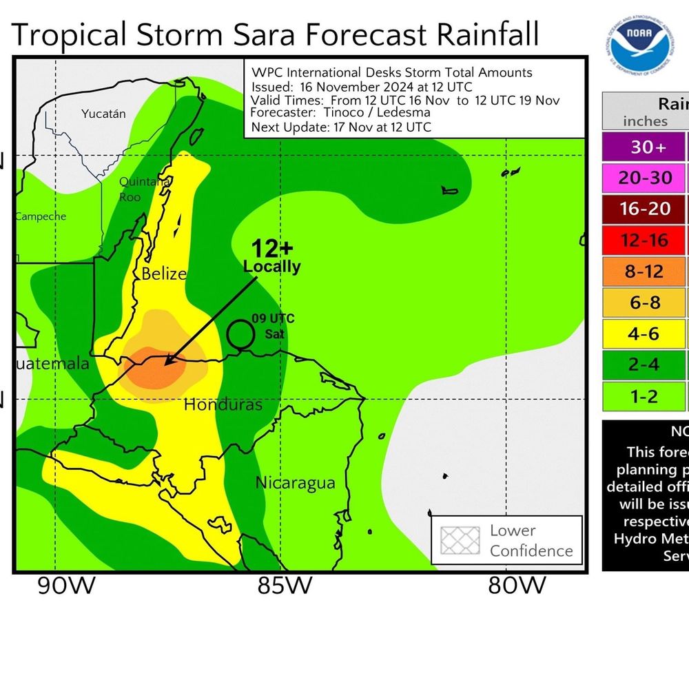
RAINFALL: Additional rainfall amounts of 1 to 3 inches are expected
over northern Honduras, with storm total amounts locally as high as
40 inches. The risk of catastrophic and life-threatening flooding
impacts will continue, especially along and near the Sierra La
Esperanza.
Across portions of Belize, El Salvador, eastern Guatemala, western
Nicaragua, and the Mexican State of Quintana Roo, Tropical
Depression Sara is expected to produce an additional 3 to 5 inches
of rain with localized storm totals around 15 inches. This will
result in areas of flash flooding, perhaps significant, along with
the potential of mudslides.
For a complete depiction of forecast rainfall associated with
Tropical Depression Sara, please see the National Weather Service
Storm Total Rainfall Graphic, available at
hurricanes.gov/refresh/graphics_at4+shtml/205755.shtml?
rainqpf#contents
NEXT ADVISORY
-------------
Next complete advisory at 900 PM CST.
$$
Forecaster Papin

Tropical Depression Sara 5-Day Uncertainty Track Image

Tropical Depression Sara 34-Knot Wind Speed Probabilities
Atlantic Tropical Depression Sara Advisory Number 17 issued at Sun, 17 Nov 2024 20:35:05 +0000
...SARA STILL ASSOCIATED WITH HEAVY RAINFALL OVER PORTIONS OF THE YUCATAN PENINSULA AND CENTRAL AMERICA...
Additional Details Here.
17.11.2024 20:40 — 👍 15 🔁 3 💬 1 📌 1

000
WTNT34 KNHC 171140
TCPAT4
BULLETIN
Tropical Storm Sara Intermediate Advisory Number 15A
NWS National Hurricane Center Miami FL AL192024
600 AM CST Sun Nov 17 2024
...SARA NEARING LANDFALL ALONG THE BELIZE COAST WITH HEAVY RAINS
MOVING INLAND OVER PORTIONS OF THE YUCATAN PENINSULA...
SUMMARY OF 600 AM CST...1200 UTC...INFORMATION
----------------------------------------------
LOCATION...16.7N 87.9W
ABOUT 60 MI...95 KM SSE OF BELIZE CITY
MAXIMUM SUSTAINED WINDS...40 MPH...65 KM/H
PRESENT MOVEMENT...WNW OR 295 DEGREES AT 5 MPH...7 KM/H
MINIMUM CENTRAL PRESSURE...1002 MB...29.59 INCHES
WATCHES AND WARNINGS
--------------------
CHANGES WITH THIS ADVISORY:
None
SUMMARY OF WATCHES AND WARNINGS IN EFFECT:
A Tropical Storm Warning is in effect for...
* The Northern coast of Honduras from Punta Castilla westward to the
Honduras-Guatemala border
* The Bay Islands of Honduras
* The Caribbean Sea coast of Guatemala
* The coast of Belize
* The coast of Mexico from Puerto Costa Maya southward to Chetumal
A Tropical Storm Warning means that tropical storm conditions are
expected somewhere within the warning area.
Interests elsewhere in the Yucatan Peninsula should monitor the
progress of this system.
For storm information specific to your area, please monitor
products issued by your national meteorological service.
DISCUSSION AND OUTLOOK
----------------------
At 600 AM CST (1200 UTC), the center of Tropical Storm Sara was
located near latitude 16.7 North, longitude 87.9 West. Sara is
moving toward the west-northwest near 5 mph (7 km/h) and this
general motion with some increase in forward speed is expected
through tonight. On the forecast track, the center of Sara will make
landfall in Belize later this morning or around midday.
Maximum sustained winds are near 40 mph (65 km/h) with higher gusts.
Only small fluctuations in strength are anticipated until landfall.
Weakening is forecast after the storm moves inland, and dissipation
is expected over the southern portion of the Yucatan Peninsula
tonight or on Monday.
Tropical-storm-force winds extend outward up to 105 miles (165 km)
from the center.
The estimated minimum central pressure is 1002 mb (29.59 inches).
HAZARDS AFFECTING LAND
----------------------
Key Messages for Tropical Storm Sara can be found in the Tropical
Cyclone Discussion under AWIPS header MIATCDAT4 and WMO header
WTNT44 KNHC and on the web at hurricanes.gov/text/MIATCDAT4.shtml
RAINFALL: Through early next week, rainfall amounts of 15 to 25
inches with isolated storm totals around 40 inches area expected
over northern Honduras. This rainfall will lead to widespread areas
of life-threatening and potentially catastrophic flash flooding and
mudslides, especially along and near the Sierra La Esperanza.
Elsewhere across the rest of Honduras, Belize, El Salvador, eastern
Guatemala, western Nicaragua, and the Mexican State of Quintana Roo,
Tropical Storm Sara is expected to produce 5 to 10 inches of rain
with localized totals around 15 inches through early next week. This
will result in areas of flash flooding, perhaps significant, along
with the potential of mudslides.
For a complete depiction of forecast rainfall associated with
Tropical Storm Sara, please see the National Weather Service Storm
Total Rainfall Graphic, available at
hurricanes.gov/refresh/graphics_at4+shtml/205755.shtml?
rainqpf#contents
WIND: Tropical storm conditions, especially in gusts, are expected
in the warning area in portions of Honduras, Guatemala, Belize,
and the Yucatan Peninsula of Mexico during the next several hours.
STORM SURGE:
A storm surge could raise water levels by as much as 1 to 3 feet
above ground level near and to the north of where the center of Sara
crosses the coast of Belize. Near the coast, the surge will be
accompanied by large and destructive waves.
NEXT ADVISORY
-------------
Next complete advisory at 900 AM CST.
$$
Forecaster Papin

Tropical Storm Sara 5-Day Uncertainty Track Image

Tropical Storm Sara 34-Knot Wind Speed Probabilities
Atlantic Tropical Storm Sara Intermediate Advisory Number 15A issued at Sun, 17 Nov 2024 11:40:26 +0000
...SARA NEARING LANDFALL ALONG THE BELIZE COAST WITH HEAVY RAINS MOVING INLAND OVER PORTIONS OF THE YUCATAN PENINSULA...
Additional Details Here.
17.11.2024 11:50 — 👍 14 🔁 2 💬 0 📌 0
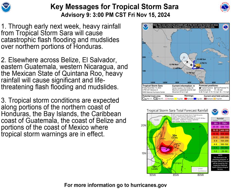
Here are the Tropical Storm #Sara Key Messages for Friday afternoon. The latest advisory is at https://t.co/tW4KeGe9uJ https://t.co/RdzdmDfM0G
15.11.2024 22:08 — 👍 23 🔁 4 💬 0 📌 2

869
WTNT34 KNHC 152331
TCPAT4
BULLETIN
Tropical Storm Sara Intermediate Advisory Number 9A
NWS National Hurricane Center Miami FL AL192024
600 PM CST Fri Nov 15 2024
...SARA CRAWLING WESTWARD NEAR THE HONDURAS COAST...
...CATASTROPHIC FLOODING AND MUDSLIDES ONGOING FOR PORTIONS OF
CENTRAL AMERICA...
SUMMARY OF 600 PM CST...0000 UTC...INFORMATION
----------------------------------------------
LOCATION...16.2N 86.3W
ABOUT 35 MI...55 KM SW OF ISLA GUANAJA HONDURAS
ABOUT 155 MI...250 KM SE OF BELIZE CITY
MAXIMUM SUSTAINED WINDS...50 MPH...85 KM/H
PRESENT MOVEMENT...W OR 270 DEGREES AT 2 MPH...4 KM/H
MINIMUM CENTRAL PRESSURE...997 MB...29.44 INCHES
WATCHES AND WARNINGS
--------------------
CHANGES WITH THIS ADVISORY:
None.
SUMMARY OF WATCHES AND WARNINGS IN EFFECT:
A Tropical Storm Warning is in effect for...
* The Northern coast of Honduras from Punta Patuca westward to the
Honduras-Guatemala border.
* The Bay Islands of Honduras
* The Caribbean Sea coast of Guatemala
* The coast of Belize
* The coast of Mexico from Puerto Costa Maya southward to Chetumal
A Tropical Storm Warning means that tropical storm conditions are
expected somewhere within the warning area.
Interests elsewhere in the Yucatan Peninsula should monitor the
progress of this system.
For storm information specific to your area, please monitor
products issued by your national meteorological service.
DISCUSSION AND OUTLOOK
----------------------
At 600 PM CST (0000 UTC), the center of Tropical Storm Sara was
located near latitude 16.2 North, longitude 86.3 West. Sara is
moving toward the west near 2 mph (4 km/h). A continued slow
westward motion is expected over the next day or so, followed by a
more west-northwestward motion beginning late Saturday. On the
forecast track, the center of Sara will continue to move near the
northern coast of Honduras during the next day or so before
approaching Belize, and then move onshore in Belize during the day
on Sunday.
Maximum sustained winds are near 50 mph (85 km/h) with higher
gusts. Some slight strengthening is possible over the next day or
so, as long as the system remains offshore.
Tropical-storm-force winds extend outward up to 115 miles (185 km)
from the center.
The estimated minimum central pressure is 997 mb (29.44 inches).
HAZARDS AFFECTING LAND
----------------------
Key Messages for Tropical Storm Sara can be found in the Tropical
Cyclone Discussion under AWIPS header MIATCDAT4 and WMO header
WTNT44 KNHC and on the web at hurricanes.gov/text/MIATCDAT4.shtml
RAINFALL: Through early next week, rainfall amounts of 15 to 25
inches with isolated storm totals around 35 inches are expected
over northern Honduras. This rainfall will lead to widespread areas
of life-threatening and potentially catastrophic flash flooding and
mudslides, especially along and near the Sierra La Esperanza.
Elsewhere across the rest of Honduras, Belize, El Salvador, eastern
Guatemala, western Nicaragua, and the Mexican State of Quintana Roo,
Tropical Storm Sara is expected to produce 5 to 10 inches of rain
with localized totals around 15 inches through early next week. This
will result in areas of flash flooding, perhaps significant, along
with the potential of mudslides.
For a complete depiction of forecast rainfall associated with
Tropical Storm Sara, please see the National Weather Service Storm
Total Rainfall Graphic, available at
hurricanes.gov/refresh/graphics_at4+shtml/205755.shtml?
rainqpf#contents
WIND: Tropical storm conditions are expected in the warning area in
Honduras during the next couple of days. Tropical storm conditions
are expected in Guatemala, Belize, and portions of Mexico beginning
on Saturday.
STORM SURGE: Storm surge could raise water levels by as much as 1 to
3 feet above normal tide levels along the immediate coast in areas
of onshore winds along the northern coast of Honduras. Near the
coast, the surge will be accompanied by large and destructive waves.
A storm surge could raise water levels by as much as 1 to 3 feet
above ground level near and to the north of where the center of Sara
crosses the coast of Belize.
NEXT ADVISORY
-------------
Next complete advisory at 900 PM CST.
$$
Forecaster Blake

Tropical Storm Sara 5-Day Uncertainty Track Image

Tropical Storm Sara 34-Knot Wind Speed Probabilities
Atlantic Tropical Storm Sara Intermediate Advisory Number 9A issued at Fri, 15 Nov 2024 23:31:42 +0000
...SARA CRAWLING WESTWARD NEAR THE HONDURAS COAST... ...CATASTROPHIC FLOODING AND MUDSLIDES ONGOING FOR PORTIONS OF CENTRAL AMERICA...
Additional Details Here.
15.11.2024 23:40 — 👍 15 🔁 4 💬 0 📌 0
National Hurricane Center issues ADVISORY 8 for TROPICAL STORM SARA
at Fri, 15 Nov 2024 14:47:24 +0000 via IEMbot
Additional Details Here.
15.11.2024 15:06 — 👍 1 🔁 1 💬 0 📌 0

ZCZC MIATWOAT ALL<br>TTAA00 KNHC DDHHMM<br><br>Tropical Weather Outlook<br>NWS National Hurricane Center Miami FL<br>700 AM EST Fri Nov 15 2024<br><br>For the North Atlantic...Caribbean Sea and the Gulf of Mexico:<br><br>Active systems:<br>The National Hurricane Center is issuing advisories on Tropical <br>Storm Sara, located near the northern coast of Honduras. <br><br>Tropical cyclone formation is not expected during the next 7 days.<br><br>$$<br>Forecaster Kelly<br>NNNN<br><br><br>

Atlantic 2-Day Graphical Outlook Image

Atlantic 7-Day Graphical Outlook Image
NHC Atlantic Outlook update for Fri, 15 Nov 2024 14:47:15 GMT
Additional Details Here.
15.11.2024 14:50 — 👍 5 🔁 1 💬 0 📌 0

977
WTNT34 KNHC 151447
TCPAT4
BULLETIN
Tropical Storm Sara Advisory Number 8
NWS National Hurricane Center Miami FL AL192024
900 AM CST Fri Nov 15 2024
...SARA SLOWING DOWN BETWEEN THE BAY ISLANDS AND NORTHERN MAINLAND
OF HONDURAS...
...CATASTROPHIC FLOODING AND MUDSLIDES ONGOING FOR PORTIONS OF
CENTRAL AMERICA...
SUMMARY OF 900 AM CST...1500 UTC...INFORMATION
----------------------------------------------
LOCATION...16.1N 86.0W
ABOUT 30 MI...45 KM SSW OF ISLA GUANAJA HONDURAS
ABOUT 175 MI...280 KM ESE OF BELIZE CITY
MAXIMUM SUSTAINED WINDS...50 MPH...85 KM/H
PRESENT MOVEMENT...W OR 270 DEGREES AT 5 MPH...7 KM/H
MINIMUM CENTRAL PRESSURE...997 MB...29.44 INCHES
WATCHES AND WARNINGS
--------------------
CHANGES WITH THIS ADVISORY:
The government of Belize has issued a Tropical Storm Warning from
Belize City southward to the Belize-Guatemala border.
SUMMARY OF WATCHES AND WARNINGS IN EFFECT:
A Tropical Storm Warning is in effect for...
* The Northern coast of Honduras.
* The Bay Islands of Honduras
* The Caribbean Sea coast of Guatemala
* The coast of Belize from Belize City southward to
the Belize-Guatemala border.
A Tropical Storm Warning means that tropical storm conditions are
expected somewhere within the warning area.
Interests elsewhere in Belize and the Yucatan Peninsula should
monitor the progress of this system. Additional Watches and Warnings
could be required for portions of these areas later this afternoon.
For storm information specific to your area, please monitor
products issued by your national meteorological service.
DISCUSSION AND OUTLOOK
----------------------
At 900 AM CST (1500 UTC), the center of Tropical Storm Sara was
located near latitude 16.1 North, longitude 86.0 West. Sara is
moving toward the west near 5 mph (7 km/h). A continued slow
westward motion is expected over the next day or so, but a
west-northwestward motion is forecast to begin by late Saturday. On
the forecast track, the center of Sara will continue to move close
to the northern coast of Honduras through early Saturday before
approaching Belize, and ultimately moving onshore in Belize during
the day on Sunday.
Maximum sustained winds are near 50 mph (85 km/h) with higher gusts.
Some slight strengthening is possible over the next couple of days
as long as Sara remains offshore of the coast of Honduras.
Tropical-storm-force winds extend outward up to 115 miles (185 km)
from the center.
The estimated minimum central pressure is 997 mb (29.44 inches).
HAZARDS AFFECTING LAND
----------------------
Key Messages for Tropical Storm Sara can be found in the Tropical
Cyclone Discussion under AWIPS header MIATCDAT4 and WMO header
WTNT44 KNHC and on the web at hurricanes.gov/text/MIATCDAT4.shtml
RAINFALL: Through early next week, rainfall amounts of 15 to 25
inches with isolated storm totals around 35 inches area expected
over northern Honduras. This rainfall will lead to widespread areas
of life-threatening and potentially catastrophic flash flooding and
mudslides, especially along and near the Sierra La Esperanza.
Elsewhere across the rest of Honduras, Belize, El Salvador, eastern
Guatemala, western Nicaragua, and the Mexican State of Quintana Roo,
Tropical Storm Sara is expected to produce 5 to 10 inches of rain
with localized totals around 15 inches through early next week. This
will result in areas of flash flooding, perhaps significant, along
with the potential of mudslides.
For a complete depiction of forecast rainfall associated with
Tropical Storm Sara, please see the National Weather Service Storm
Total Rainfall Graphic, available at
hurricanes.gov/refresh/graphics_at4+shtml/205755.shtml?
rainqpf#contents
WIND: Tropical storm conditions are expected in the warning area in
Honduras during the next couple of days. Tropical storm conditions
are expected in Guatemala and Belize beginning on Saturday.
STORM SURGE: Storm surge could raise water levels by as much as 1 to
3 feet above normal tide levels along the immediate coast in areas
of onshore winds along the northern coast of Honduras. Near the
coast, the surge will be accompanied by large and destructive waves.
A storm surge could raise water levels by as much as 1 to 3 feet
above ground level near and to the north of where the center of Sara
crosses the coast of Belize.
NEXT ADVISORY
-------------
Next intermediate advisory at 1200 PM CST.
Next complete advisory at 300 PM CST.
$$
Forecaster Papin

Tropical Storm Sara 5-Day Uncertainty Track Image

Tropical Storm Sara 34-Knot Wind Speed Probabilities
Atlantic Tropical Storm Sara Advisory Number 8 issued at Fri, 15 Nov 2024 14:47:25 +0000
...SARA SLOWING DOWN BETWEEN THE BAY ISLANDS AND NORTHERN MAINLAND OF HONDURAS... ...CATASTROPHIC FLOODING AND MUDSLIDES ONGOING FOR PORTIONS OF CENTRAL AMERICA...
Additional Details Here.
15.11.2024 14:50 — 👍 24 🔁 5 💬 0 📌 0

The combination of #Sara's interaction with Central America and then wind shear moving in over the Gulf of Mexico will likely lead to its demise next week.
Regardless, its moisture will likely reach Florida by Wednesday.
15.11.2024 16:47 — 👍 5 🔁 0 💬 0 📌 0
The combination of #Sara's interaction with Central America and then wind shear moving in over the Gulf of Mexico will likely lead to its demise next week.
Regardless, its moisture will likely reach Florida by Wednesday.
15.11.2024 16:46 — 👍 0 🔁 0 💬 0 📌 0
 15.11.2024 13:02 — 👍 54517 🔁 7328 💬 735 📌 260

Interesting Spaghetti Models on Sara….. But I have a feeling it will be what ever is left of Sara!
15.11.2024 16:15 — 👍 3 🔁 0 💬 0 📌 0
Thanks for all the New followers. I’m also on Facebook at first alert hurricane tracker, so please follow me there as well.
15.11.2024 14:58 — 👍 3 🔁 0 💬 0 📌 0
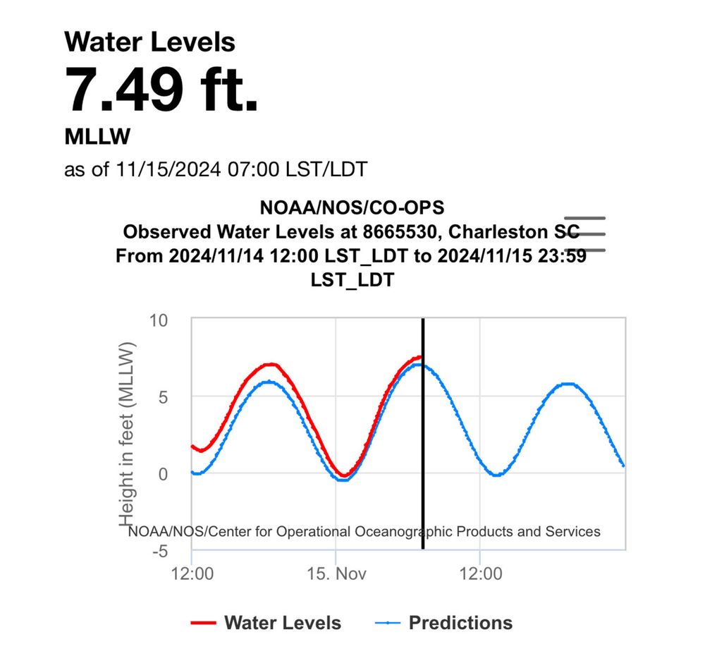
Water levels in Charleston Harbor are peaking near 7.5’ MLLW. Be ready to reroute around road closures downtown over the next couple hours.
15.11.2024 12:12 — 👍 1 🔁 1 💬 1 📌 0


Tropical Storm Sara more WSW trend means more time with land interaction hurting ability to form proper structure & intensify into Gulf. NHC has system dissipating over Yucatan Peninsula Sun/Mon. This scenario means no US threat. Heavy rain Central America-Yucatan region. 15Nov24
15.11.2024 12:27 — 👍 2 🔁 1 💬 0 📌 0

An amazing face-on view of the spiral galaxy M51, dubbed the Whirlpool Galaxy.
(Credit: NASA, ESA, S. Beckwith (STScI) and the Hubble Heritage Team/STScI/AURA)
14.11.2024 18:21 — 👍 9774 🔁 463 💬 71 📌 31
Today I will be mainly recovering from visiting 4 volcanoes in Italy in a week for a science doc. And eating many, many fine Neapolitan pizzas. This is either Stromboli, or my digestive system.
14.11.2024 11:07 — 👍 26678 🔁 585 💬 447 📌 43


We are continuing when to watch Sarah as it pushes into Central America. Once it gets into the go of Campeche will it be strong enough to survive and move toward Florida?
15.11.2024 06:48 — 👍 3 🔁 0 💬 0 📌 0

...The Flood Warning is extended for the following rivers in
Arkansas...
Black River At Black Rock affecting Lawrence, Jackson and
Independence Counties.
...The Flood Warning continues for the following rivers in
Arkansas...
White River At Augusta affecting Woodruff and White Counties.
For the Lower White River...including Newport, Augusta, Georgetown,
Des Arc, Clarendon...Minor flooding is forecast.
* WHAT...Minor flooding is occurring.
* WHERE...Black River at Black Rock.
* WHEN...Until early Saturday morning.
* IMPACTS...At 14.0 feet, Minor flooding begins. Farm ground along
east bank begins to flood.
* ADDITIONAL DETAILS...
- At 8:00 PM CST Thursday the stage was 14.1 feet.
- Forecast...The river is expected to fall below flood stage
late Thursday night, and continue falling to 8.8 feet by
Tuesday evening.
- Flood stage is 14.0 feet.
- http://www.weather.gov/safety/flood

...The Flood Warning is extended for the following rivers in
Arkansas...
Black River At Black Rock affecting Lawrence, Jackson and
Independence Counties.
...The Flood Warning continues for the following rivers in
Arkansas...
White River At Augusta affecting Woodruff and White Counties.
For the Lower White River...including Newport, Augusta, Georgetown,
Des Arc, Clarendon...Minor flooding is forecast.
* WHAT...Minor flooding is occurring and minor flooding is forecast.
* WHERE...White River at Augusta.
* WHEN...Until Saturday, November 23.
* IMPACTS...At 28.0 feet, Roads in Henry Gray Hurricane Lake
Wildlife Management area flooded. Thousands of acres of cultivated
land flooded in White and Woodruff counties.
* ADDITIONAL DETAILS...
- At 8:00 PM CST Thursday the stage was 28.6 feet.
- Forecast...The river is expected to fall below flood stage
Friday, November 22 and continue falling to 23.8 feet Sunday,
November 24.
- Flood stage is 26.0 feet.
- http://www.weather.gov/safety/flood
🚨 Flood Warning issued November 14 at 9:17PM CST until November 16 at 3:04AM CST by NWS Little Rock AR 🚨
Additional Details Here.
15.11.2024 03:30 — 👍 1 🔁 1 💬 0 📌 0

NEW: #Sara has officially been named. It has winds of 40 mph and is about 50 miles offshore of the Honduras-Nicaragua border:
14.11.2024 17:49 — 👍 8 🔁 1 💬 0 📌 0

Rain moving into the area from the southwest. It'll last into evening.
Rain moving in. Dry times may be few into the evening.
Since we haven't had a wet commute in a while, please try not to drive as poorly as normal.
14.11.2024 20:34 — 👍 261 🔁 25 💬 6 📌 11

Much more sunshine arrives for Friday and the weekend, and temperatures stay generally within striking distance of mid-November normals. Coastal flooding continues to be a concern as well, especially this weekend. Details: chswx.com
14.11.2024 22:51 — 👍 2 🔁 1 💬 0 📌 0
 14.11.2024 11:01 — 👍 70528 🔁 4000 💬 845 📌 157
D.C.-area and worldwide weather news from The Washington Post.
http://www.capitalweather.com | info@capitalweather.com
All aboard the struggle bus ✨
tiktok.com/@sneakcret
Mostly looking for safety from the algorithms. #Eurovision obsessive and #F1 fan. Designer, writer and campaigner working with people and organisations to try make the world a better place.
Investigativ Journalist & Documentary-Photographer, Podcaster, Ex-Officer: focusing on 🇺🇦 / 🇬🇪 Counter-Russian-🇷🇺-Propagandist
📍 Berlin based 🌍/ DM for business inquiries:
📷:patrick_enssle
https://www.patrick-enssle.de
Keeping you ahead of the storm since 2008. Download for FREE! myradar.com
We are a group of weather enthusiasts who like to share weather data amongst ourselves and with both Jackson & Louisville KY NWS offices. Why not join us and #ShareYourWeather! #ekywx #kywx
Not official. Not going to sit idly by either though.
Please visit https://www.nhc.noaa.gov/mobile/ directly for more weather info.
@rogue-nhc-atlantic.bsky.social
@rogue-nhc-pacific.bsky.social
@rogue-hc-centpac.bsky.social
Where facts, experts, fearless media, and the ferocious opposition meet. We're fighting back against the American autocratic movement and fighting forward to create the America we all deserve. Join us. https://lincolnsquare.media
Unofficial bot sharing alerts from NWS Tampa Bay Ruskin FL.
This account is not monitored. Contact @wandrme.paxex.aero if needed.
Unofficial bot sharing alerts from NWS New York (Upton) NY.
This account is not monitored. Contact @wandrme.paxex.aero if needed.
Unofficial bot sharing alerts from NWS Seattle WA.
This account is not monitored. Contact @wandrme.paxex.aero if needed.
Unofficial bot sharing alerts from NWS Boston/Norton MA.
This account is not monitored. Contact @wandrme.paxex.aero if needed.
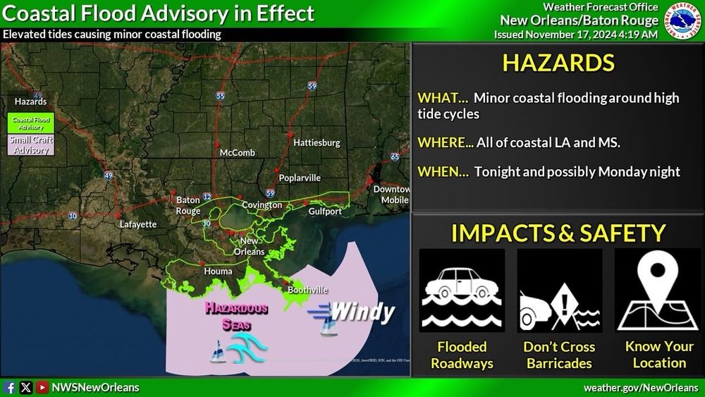
Unofficial bot sharing alerts from NWS New Orleans LA.
This account is not monitored. Contact @wandrme.paxex.aero if needed.
Unofficial bot sharing alerts from National Hurricane Center - Atlantic.
This account is not monitored. Contact @wandrme.paxex.aero if needed.
American. Journalist. New York Times Opinion writer and MSNBC political analyst.
Senior legal affairs reporter at POLITICO with a focus on democracy, the balance of power and the clash between the Trump administration and courts.
Mother. Wife. Actress. Author. Advocate. Student.
Weather forecasts and alerts for the Charleston, SC metro area (Berkeley/Charleston/Dorchester counties), first popularized on Twitter by @jaredwsmith.com.
⛈️ https://chswx.com
🐘 https://chswx.social/@chswx
The fastest growing independent news network in the world. We cover breaking news, politics, law and more. We are unapologetically pro-democracy.
Trump is a dumbfuck.
We apologize to 🇨🇦 and 🇲🇽 for the 🍊🤡