YouTube video by Deutscher Alpenverein (DAV)
Was passiert, wenn der Berg bröckelt? Klimawandelfolgen in den Alpen, Teil 3
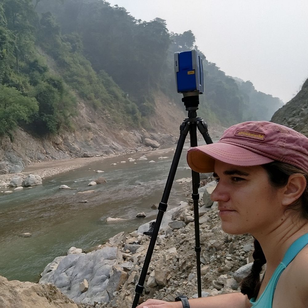
What happens to mountain trails, hiking infrastructure and safety as glaciers retreat and the terrain becomes unstable? We recently had the exciting chance to share insights from our ReHIKE project in a great film by the Deutscher Alpenverein.
www.youtube.com/watch?v=0XS5...
11.10.2025 07:42 — 👍 0 🔁 0 💬 0 📌 0
Happy to share our new paper on #remotesensing of #peatlands 👇! Our research can inform understanding on how #Sentinel-1 #SAR data can support the mapping of this unique habitat and provide some insight into its relative condition. Many thanks to @jarrettinho.bsky.social for the great collaboration.
15.09.2025 07:06 — 👍 2 🔁 2 💬 0 📌 0
Great success for our group! We obtained funding for two highly reputable projects from @fwf-at.bsky.social: D. Hölbling leads the project "MorphEO - Big Earth observation for geomorphic mapping and monitoring", and Z. Dabiri leads "Urban flood impact on transport systems in Poland & Austria". 👏🥳
10.08.2025 17:22 — 👍 2 🔁 0 💬 0 📌 1
Meet our team at the #LPS25 poster sessions:
23.06, 17:45, R25 – CopPhil, Carla Arellano
24.06, 17:45, F05 – Rock Glaciers (InSAR), Elena Nafieva
26.06, 17:45, Q01 – Glacier Retreat, Zahra Dabiri
27.06, 13:00, M25 – DL Rock Glacier Mapping, Vanessa Streifeneder
See you there!
23.06.2025 14:39 — 👍 2 🔁 0 💬 0 📌 0
We can’t believe the #EGU25 is already half way through! We’re very grateful for all the discussions, new contacts, and meeting old friends! You can find us for the rest of the week at:
30.04.2025 12:40 — 👍 2 🔁 0 💬 0 📌 0
Hall X2 from 10:45 to 12:30 features work from our ReHIKE project:
X2.50 - Tracking river course dynamics in Alpine glacier forelands with #SITS presented by Lorena Abad
X2.55 - Glacier retreat and slope instabilities: impact on alpine infrastructure assessed with #InSAR presented by Zahra Dabiri
28.04.2025 05:26 — 👍 1 🔁 0 💬 0 📌 0
#EGU25 is starting today and our group kickstarts showcasings of our projects with 3 different posters.
Hall X2 - 8:30 to 10:15 with results from the ROGER project:
X2.38 - How well do InSAR measurements align with rock glaciers in the Austrian Alps presented by Elena Nafieva
#InSAR #rockglacier
28.04.2025 05:26 — 👍 2 🔁 0 💬 1 📌 0

Pleased to see my research with Daniel Hölbling used as part of the Environment Agency's Working With Nature report on the benefits of #naturalfloodmanagement.
#gis #sentinel1 #remotesensing can play a part in monitoring
www.gov.uk/government/n...
30.03.2025 18:15 — 👍 2 🔁 1 💬 0 📌 0

Recently, we had the kick-of meeting for our new project SpaDiFloVur (Spatial differentiation of the level of flood vulnerability of municipalities in Poland and Austria) at the University of Łódź. It was an excellent meeting with fruitful discussions, and we look forward to the upcoming work.
14.02.2025 10:13 — 👍 2 🔁 1 💬 0 📌 0
Environmental economist focused on regulatory impact, adaptation, and resilience. I translate complex research into clear insights for decision-makers. Views are my own, not my agency’s; sharing or liking isn’t an endorsement.
Account des Österreichischen Alpenvereins. www.alpenverein.at
Communication strategist | MSc Geography (Global Change & Natural Hazards) | Storytelling on science, sustainability & outdoor sports | Outdoor sport & health advocate | Inspiring the next generation to step outside 🌿
Der Wissenschaftsfonds FWF ist Österreichs zentrale Einrichtung zur Förderung der Grundlagenforschung.
www.fwf.ac.at
scilog – das Wissenschaftsmagazin des FWF:
scilog.fwf.ac.at
I make ice cream and do science and suck at fly fishing. YYC
glaciers - geohazards - climate - geomorphology - geomatics - gelato
He/him
Fellow, RCGS
ECMWF senior scientist working on monitoring global #wildfire emissions, #airquality, atmospheric chemistry & #scicomm for the #CopernicusAtmosphere Monitoring Service @copernicusecmwf.bsky.social @ecmwf.int
Vice-Chancellor at the University of Hull in England. Landslides, hazards, risk, vulnerability and resilience, plus a bit of Coventry City. #pusb #Breturn
Research, news, and commentary from Nature, the international science journal. For daily science news, get Nature Briefing: https://go.nature.com/get-Nature-Briefing
Holding a PhD in hydrology, interested in sediment transport issues and all things #geospatial. Love mountains, mystery stories and #rstats 🤎
Researcher @ Manaaki Whenua – Landcare Research
🌐 https://anatolii.nz | 🐙 https://github.com/atsyplenkov
Integrated Research Infrastructure Services for Climate Change Risks; Service catalogue & 1st access call launch: April 2025! Stay Tuned!
www.iriscc.eu
Field and experimental geomorphologist! Fascinated by sediment transport, dunes, rivers, floods. Associate professor at ENS Paris, geology department. 🚴🏃🏻♀️🧗🥾🏞️
Head of Lab. for Geomorphology & Geoecology, Heidelberg Uni | Assoc. Research Fellow at Geological Survey of 🇧🇪 | Corresponding Member, German Archaeol. Inst. (DAI) | #tsunami #geomorphology #Quaternary #geoarchaeology #proclimateaction | views are my own
I am a professor of tropical ecology at the University of York. I have a passion for Mountain ecosystems and cultures across the Global South, particularly in Kenya and Tanzania where I work with many Universities, NGOs and Government organisations.
Geoinformatics Consultant (Nature-based Solutions & Economic Development), QGIS, Charlton Athletic fan, European
https://geohazards.group
Landslides and more at Charles University in Prague, Czechia
Eos is a leading source for trustworthy news and perspectives about the Earth and space sciences and their impact. Published by the American Geophysical Union (@agu.org).
Science writer, teacher, cellist, horsegirl.
We produce geospatial science and solutions for society. Part of the National Land Survey of Finland (NLS). fgi.fi
Intergovernmental treaty providing frameworks for the conservation & wise use of wetlands & their resources.
www.ramsar.org
Create and share social media content anywhere, consistently.
Built with 💙 by a global, remote team.
⬇️ Learn more about Buffer & Bluesky
https://buffer.com/bluesky