Magnitude 6 #earthquake near Jalalabad in E #Afghanistan, close to the border with Pakistan.
Mechanism is thrust on a shallow SE or NW dipping fault.
General context is the India-Asia collision which placed the region under a N-S shortening. ⚒️
01.09.2025 06:03 — 👍 9 🔁 2 💬 0 📌 1
We are entering a new era for tsunami observations and model validation-- The SWOT era! Thanks a lot @baptistegomb.bsky.social for reaching out, this was a fun collaboration. Also great working with @diegosismologo.bsky.social and @valah.bsky.social. @haskoliislands.bsky.social
11.08.2025 13:18 — 👍 7 🔁 2 💬 0 📌 0

Superb observation by the SWOT altimetry satellite of the July 30 #tsunami. Data acquired ~1h after the M8.8 Kamchatka earthquake show the waves propagating across the Pacific with a great agreement with @rocangel.bsky.social's model!
[more here](www.aviso.altimetry.fr/fr/missions/...)
#CNES #CLS
11.08.2025 09:51 — 👍 19 🔁 5 💬 1 📌 1
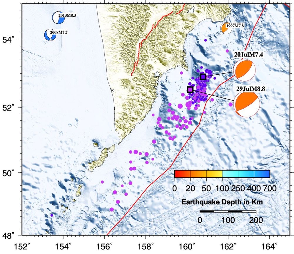
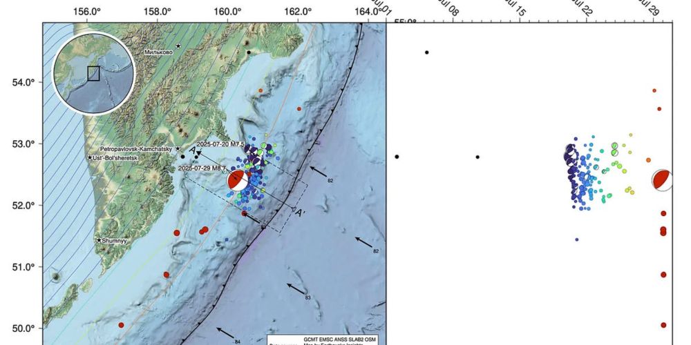
Earthquake sequences of Kamchatka this month. Pink is M8.8 aftershock sequence.
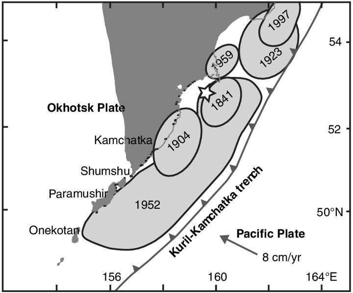
Macinnes et al. (2010) rupture zones
The aftershock zone of today’s M8.8 Kamchatka megathrust #earthquake is comparable to the rupture area of the 1952 rupture zone from Macinnes et al. (2010). At a rate of 8 cm/year, the accumulated slip of 6 m since 1952 matches with the preliminary rupture model of today’s earthquake pretty well. 🧪⚒️
30.07.2025 10:57 — 👍 78 🔁 32 💬 3 📌 1
M8.8 earthquake strikes offshore Kamchatka
A dangerous subduction megathrust ruptures once again
⚒️ 🧪
A M8.8 earthquake just ruptured the subduction zone offshore Russia’s Kamchatka peninsula. This is one of the world’s truly huge earthquakes, and a triggered tsunami is currently traveling across the Pacific ocean.
This same fault ruptured on July 20th in a M7.4, and last August in a M7.1.
30.07.2025 04:05 — 👍 175 🔁 86 💬 2 📌 9
Simulated propagation of tsunami generated by Kamchatka M8.8 earthquake. Generated by NCDR, Taiwan. 🧪⚒️⚛️
30.07.2025 05:09 — 👍 86 🔁 38 💬 3 📌 4
Canicule intense dès juin, mais c’est l’écologie qui est punitive. Il est urgent… de détricoter les mesures environnementales.
Les sdf, les pauvres, les malades, les retraités, les enfants, les agriculteurs, les ouvriers, victimes de la chaleur, comptent donc si peu pour nos parlementaires?
🤢🤢🤢
18.06.2025 06:02 — 👍 151 🔁 60 💬 10 📌 2
Delighted to see our @NERCscience @EvoFlood project research on changing flood hazard and risk profiled by @theAGU 💜 @lborouniversity
eos.org/research-spo...
16.05.2025 00:00 — 👍 13 🔁 4 💬 0 📌 0
Apparently surface rupture during the Myanmar 2025. I'm very surprised by the weak shaking along the rupture. I'm not sure if this is the main rupture (I would say no - nonetheless, VERY COOL). Author unknown, location Thazi (to be confirmed)
12.05.2025 02:18 — 👍 164 🔁 51 💬 16 📌 19
So not "altimetry-on-river" related as it is an output of my previous job, but worth sharing nonetheless :)
29.04.2025 08:04 — 👍 0 🔁 0 💬 0 📌 0
In this paper we discuss the origin of this speckle and strategies that can be used to characterize and remove its energy spectrum, ultimately leading to better ocean wave spectra retrieval. DM me for a copy!
29.04.2025 08:04 — 👍 0 🔁 0 💬 1 📌 0

CFOSAT is dedicated to the measurement of directional spectra of ocean waves, but like any radar it is strongly affected by speckle noise.
29.04.2025 08:04 — 👍 0 🔁 0 💬 1 📌 0

Our paper on the speckle noise spectrum of the SWIM instrument aboard the CFOSAT oceanography satellite is online on IEEE TGRS!
ieeexplore.ieee.org/document/109...
29.04.2025 08:04 — 👍 3 🔁 0 💬 1 📌 0
Sentinel-2 reveals the surface deformation after the 2025 #Myanmar #earthquake www.cesbio.cnrs.fr/multitemp/se...
02.04.2025 21:04 — 👍 24 🔁 6 💬 1 📌 0
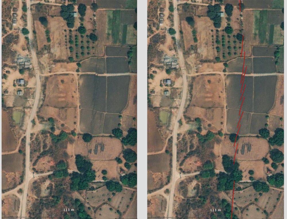
Left: excerpt of the satellite image. Different fields, dirt roads and paths, houses are visible. The earthquake rupture is visible as darker lines cutting across fields and roads. A clear lateral offset of a dirt road is also visible. To the right, same image with the earthquake rupture mapped in red.
High resolution MAXAR satellite image reveals the #Myanmar #earthquake surface rupture north of the town of Sagaing. It is close to epicenter and N tip of the >400km long rupture.
Right-lateral offset of ~3.2m is clearly illustrated by the distorsion and lateral shift of a dirt road striking E-W.
02.04.2025 08:07 — 👍 43 🔁 18 💬 0 📌 1


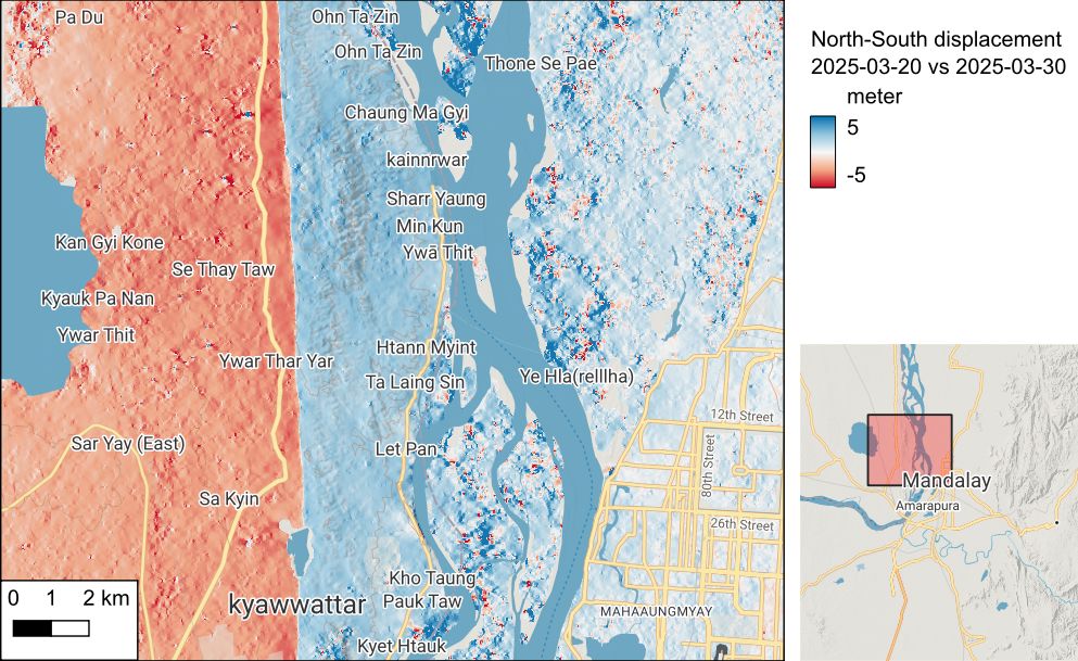
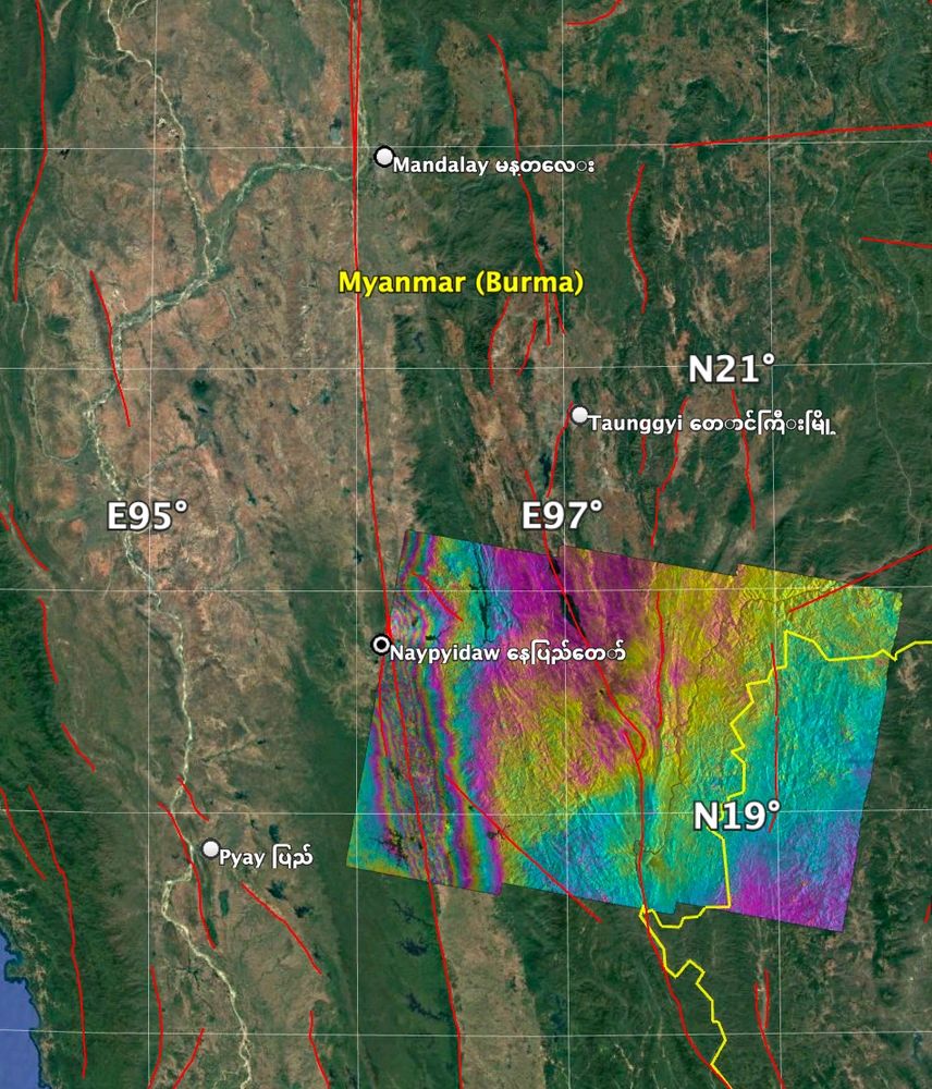
Updated processing from Sentinel-1 data over the #MyanmarEarthquake. Here are azimuth and range offsets, displacements in the indicated lines-of-sight (LOS). The azimuth offsets' LOS is better aligned with the fault strike, hence its larger displacement. Rupture extends ~400 km south of Mandalay.
02.04.2025 10:55 — 👍 15 🔁 4 💬 2 📌 0

Screenshot of Myanmar M7.7 surface rupture map service
Remote surface rupture observations for the M7.7 2025 Myanmar earthquake - soft rollout!
doi.org/10.5066/P1RY...
Simple fault trace and slip distribution from pixel tracking, high-res from available imagery. Watch for updates!
⚒️ USGS and collaborators effort led by @nadinegrr.bsky.social 🙏
01.04.2025 22:46 — 👍 52 🔁 24 💬 0 📌 2

Update: Preliminary coseismic displacements of 2025 Myanmar earthquake from @CopernicusEU @ESA #Sentinel2 images by using #CosiCorr, processed by @NTU_TW GEOG
#Copernicus
1. Rupture propagated from N to S
2. Max. offset >4m
3. Rupture length ~500km
01.04.2025 12:56 — 👍 62 🔁 26 💬 2 📌 5
The descending interferogram from Sentinel-1 (20250319-20250331) suggests that the earthquake rupture extends to 18.7 degrees and may have reached further south. More data in the next few days will reveal the full length of the rupture from this devastating earthquake.
01.04.2025 11:05 — 👍 15 🔁 7 💬 0 📌 0

Updates on the M7.7 Myanmar earthquake
An unusually long, possibly supershear rupture
🧪⚒️
Two days after the M7.7 earthquake in Myanmar, what have we learned?
Rapid seismological analyses shared by scientists suggest that the rupture was both longer and faster than expected - two factors that could have increased damage.
Read more: earthquakeinsights.substack.com/p/updates-on...
30.03.2025 19:43 — 👍 112 🔁 49 💬 3 📌 2
The latest models from the USGS show slip, and associated strong shaking, extending much further to the south. Here I have plotted contours of estimated shaking over a map of population density. Note that the fault runs south through a narrow valley that is densely populated.
⚒️ 🧪 Myanmar earthquake
29.03.2025 14:09 — 👍 57 🔁 28 💬 4 📌 1
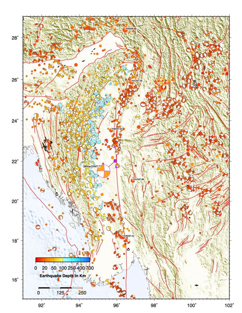
Seismicity map of the Myanmar area generated by Jascha Polet using GMT and a myriad of earthquake catalogs
A historical seismicity map shows several #earthquakes of similar size to today’s M7.7 in Myanmar occurred in the region in the early 20th century, but this section of the Sagaing fault probably hasn’t ruptured since 1839 🧪⚒️
28.03.2025 09:16 — 👍 228 🔁 88 💬 9 📌 7

The revised focal mechanism is RLSS. Wikipedia has a nice map with the fault sections on it and Ray thinks that is was the section that hasn’t ruptured since 1839.
28.03.2025 07:33 — 👍 16 🔁 14 💬 1 📌 0

Surface waves are still rolling through on my broadband in NZ:
28.03.2025 08:03 — 👍 6 🔁 2 💬 1 📌 0

First slip map for the Mw 7.8 Myanmar earthquake. Propagation of rupture towards the South. Slipnear method (Géoazur/OCA).
28.03.2025 08:17 — 👍 41 🔁 22 💬 4 📌 0
Vous avez toujours les mots justes. Merci pour votre prise de parole, et votre travail de communication de manière générale
28.02.2025 18:51 — 👍 2 🔁 0 💬 1 📌 0

Map of region of today’s M7.6 quake near the Cayman Islands with the current sequence in purple (generated by Jascha Polet)
I made a quick map of historical seismicity for the region of today’s M7.6 #earthquake near the Cayman Islands. This left lateral strike slip event occurred on a fault system that produced a few similar events in size & mechanism in the last decade.
(Good to see that USGS NEIC is still online!)🧪⚒️
09.02.2025 08:31 — 👍 60 🔁 18 💬 1 📌 0
Some beauty for the eyes
20.01.2025 08:21 — 👍 0 🔁 0 💬 0 📌 0
Fingers crossed for you and the few people I still know over there... Stay safe Eric!
08.01.2025 14:28 — 👍 1 🔁 0 💬 0 📌 0
La vie est trop cool pour se faire insulter sur Twitter, alors autant aller rigoler du rugby ailleurs.
Associate profesor in Physical Oceanography at the University of Iceland. Trying to understand through observations how mixing shapes the different properties of the water masses in the ocean through mesoscale processes.
Seismologist in Southern California. Viol player. Founder of Tempo: Music for Climate Action
We are the Technical Committee on Catchment Hydrology of the American Geophysical Union.
www.hydrocatch.weebly.com
Seismologist.
NERC Independent Research Fellow and Lecturer at University College London (UCL).
https://profiles.ucl.ac.uk/89579-stephen-hicks
Geosciences MSc • Earthquakes • Soil protection and contaminated sites • 📷 Fujifilm X-T4 and X100V • Herne, Ruhrgebiet • S04
Creator of Bluesky's FujiFeed
PhD Student 🎓| InSAR 🛰️| Volcano 🌋| Atmospheric Correction ⛈️| Machine Learning 👨💻| Tectonic 🌎| Geophysics ⚒️
Geophysicist, working on CCUS projects.
Earthquake physicist in Los Angeles; uses computer models to study how faults behave and interact
University of California graduate; Cal State faculty
maker of things | fiddle, viola, Javanese gamelan | D&D | cats | ég er að læra íslensku
he/him | aroace
@esa.int #EarthObservation: Taking the pulse of our planet from space.
Please see our Privacy Notice: http://esa.int/connectwithus
We share pictures and news on our planet as seen from space.
Playing with satellite data for atmospheric composition and earth system at #CNRM @meteofrance.com
Living and loving over the 🌈
🏳️🌈🏳️⚧️
Posts are my own.
Compte officiel de l'Institut de physique du globe de Paris. Établissement d'enseignement supérieur et de recherche en sciences de la Terre, des planètes et de l'environnement, établissement composante d'Université Paris Cité.
Seismologist, Continuous learner
https://github.com/claudiodsf
https://seismicsource.org
Menswear writer. Editor at Put This On. Words at The New York Times, The Washington Post, The Financial Times, Esquire, and Mr. Porter.
If you have a style question, search:
https://dieworkwear.com/ | https://putthison.com/start-here/
Water Scientist | Associate Professor | University of Alabama
Volcano-Tectonics Research Reader at CSIC (Tenerife, Canary Islands)
Fascinated by large volume of rocks moving from mm/year to m/sec. Geodesy, geophysics, satellites (InSAR), AI/ML, geohazards conoceour. Goofy surfer.
https://pablojgonzalez.github.io/
We're the European Space Agency, keeping you posted on European space activities.
Please see our Privacy Notice: https://esa.int/connectwithus
Votre space-writer habituel ;-)
"Space Technology Monitoring Specialist" avec un peu d'humour, alsacien du Sud-Ouest et si je suis absent, c'est que je cours dans les montagnes.