NASA Selects Two Earth System Explorers Missions - NASA
These two missions were selected for continued development as part of NASA’s Earth System Explorers Program, which conducts principal investigator-led Earth
Significant news out of NASA earth science: They've finally selected two new missions for its explorers competed line, cost capped at $335M: EDGE, a next-gen lidar and successor to Icesat-2/GEDI, and STRIVE, a limb sounder for pollution and more and much-needed successor to Aura.
05.02.2026 21:54 —
👍 26
🔁 5
💬 1
📌 0
Seen it happen at least once. No fun but no easy recourse either.
04.02.2026 15:35 —
👍 0
🔁 0
💬 0
📌 0

Rock avalanche below Mt King George triggered by the 6 December 2025 Hubbard Glacier Earthquake. The runout distance is 1.4 km.
A sensational guest post by Derek Cronmiller, Theron Finley Panya Lipovsky and Jan Dettmer of the Yukon Geological Survey: Photos and Preliminary Observations from an Overview Flight of the 6 December 2025 Hubbard Glacier Earthquake, Yukon Territory, Canada.
eos.org/thelandslide...
05.01.2026 07:36 —
👍 89
🔁 39
💬 1
📌 6
Yes! @icymatters.bsky.social and I are seeking a project coordinator for using highly specialized vehicles on the Greenland ice sheet! It's a four-year position across two projects: 'Seis-Sustain' funded by the @novo-nordisk.bsky.social and 'FirnMelt' funded by @erc.europa.eu.
16.12.2025 08:38 —
👍 6
🔁 4
💬 1
📌 1
UTTERLY SURREAL LOW ANGLE GLACIER SLIDE!! 😮😱
On Saturday at 11:00 am, a 2 km-long, 25 m-high, and 150-200 m in width section detached off the Ismoil Somoni Glacier (Tajikistan) and slid down the gorge! 🧊🌊
asiaplustj.info/en/node/354309
📽️ via @volcaholic1
28.10.2025 16:10 —
👍 284
🔁 142
💬 13
📌 28
NEW: Extraordinary footage has emerged of the huge tsunami that hit Russia’s remote Kamchatka peninsula after the 8.8 magnitude earthquake on July 30th.
(🎥 Doni Nikz)
03.08.2025 22:43 —
👍 998
🔁 361
💬 52
📌 58

Sentinel-2 reveals the surface deformation after the 2025 #Myanmar #earthquake www.cesbio.cnrs.fr/multitemp/se...
02.04.2025 21:04 —
👍 24
🔁 6
💬 1
📌 0
Please share with teens or anyone you know who work with teens! #girlsinstem #glaciology #sciart #womeninstem #science this program is for teens willing to challenge themselves (**not** for just top performing students - we are open, no need to be a science or art geek either, just willing to try)
13.01.2025 20:37 —
👍 12
🔁 6
💬 0
📌 1
Late Gen Xer so easily Hunger Strike
26.01.2025 01:45 —
👍 2
🔁 0
💬 0
📌 0
Well deserved!
14.01.2025 22:56 —
👍 1
🔁 0
💬 0
📌 0
Was that with Niels?
08.01.2025 16:12 —
👍 0
🔁 0
💬 1
📌 0
A new gigantic outburst flood from Catalina lake in East Greenland [Catalinadal, Renland, Scoresbysund].
total volume: 3.4 km3
peak discharge: ~7200 m3/s
top-10 #GLOF in terms of both numbers.
previous outburst 2013
I'm sending out a press release today about it.
🧪❄️ 🥼❄️
1/x
12.12.2024 12:09 —
👍 105
🔁 41
💬 6
📌 3

Snow4Flow logo
The Snow4Flow concept paper is out! See notice in cryolist from Thursday. This will form the basis for the later AO. Stickers at #AGU24. snow4flow.lpl.arizona.edu/concept-paper
09.12.2024 00:57 —
👍 11
🔁 1
💬 0
📌 0
In work I’ve been quietly doing, many dozens of people’s stories & early writing drafts, one thing’s increasingly clear.
“Safety by Exclusion”—the dominant paradigm in polar science & most geosci sub-fields—isn’t just harmful, it’s ineffective. It DOESN’T WORK! Makes everyone less safe, in fact. 🧪⚒️
30.11.2024 16:26 —
👍 46
🔁 5
💬 4
📌 3
🧪 Well-meaning arguments to “keep science apolitical” just cede the far-right-wing propaganda framing that science…
• “used to be apolitical”,
• “recently became politicized”, and ∴
• “needs to be fixed.”
Which is 100% bullshit on every single point.
Don’t do their propaganda for them.
16.11.2024 17:16 —
👍 184
🔁 40
💬 4
📌 5

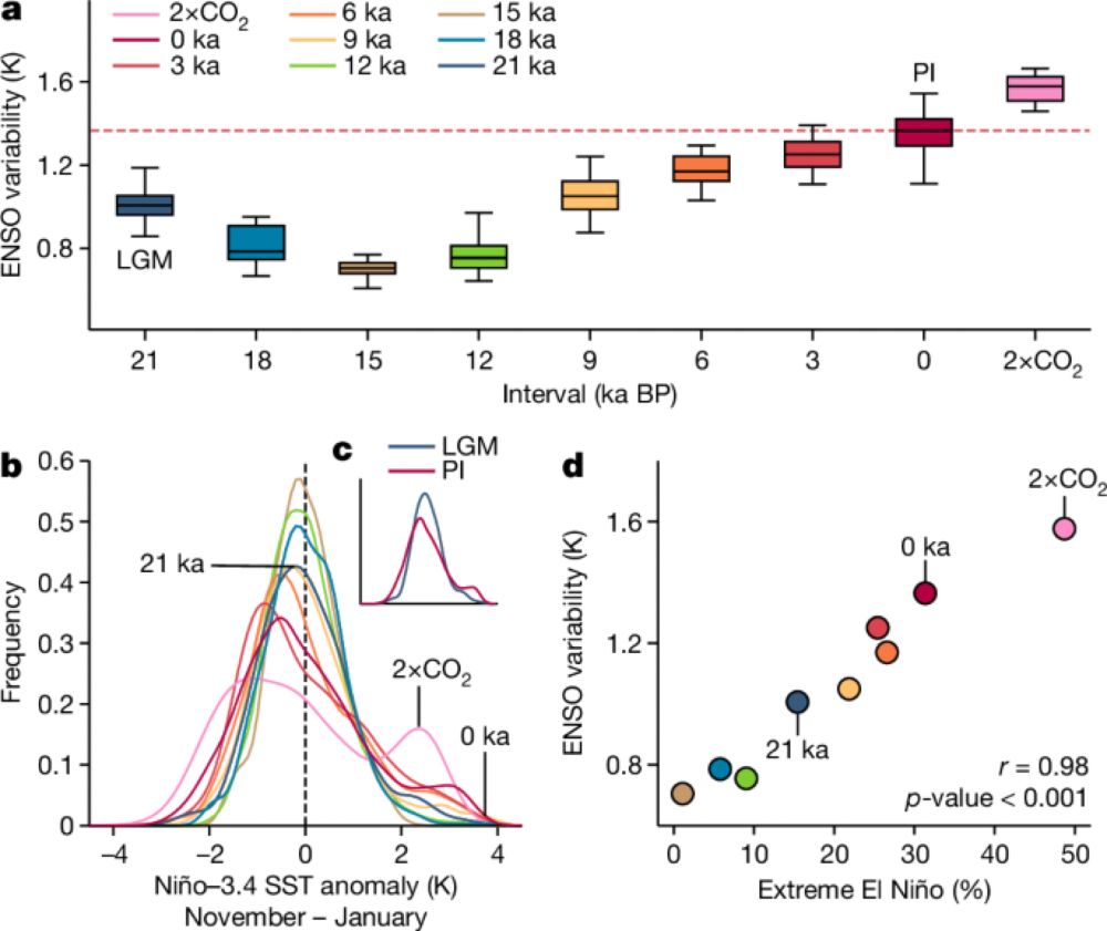
In the podcast, MacGregor describes a new method of visualizing the surface of the ice sheet in which the simulated illumination of a digital elevation model varies according to the direction of surface ice flow. (A) Map of Greenland’s surface shaded using flow-aware hillshade, in which the artificial illumination direction (and corresponding shadows) at each pixel is 90 degrees counterclockwise to the ice-flow direction. The resulting shading emphasizes small-scale variability in the ice-sheet surface slope, which is primarily related to variability in the topography under the ice. The change in shading from the middle of the ice sheet to the periphery reflects the smaller slopes in the interior and the smaller surface bumps induced by subglacial topography, because as the ice thickness decreases, the surface becomes more sensitive to what is going on below. The map is based on the laser altimetry data. (B) The green lines are manual tracings of linear features in the map. GrIMP: Greenland Ice Mapping Project.

This is the new geological map of Greenland. It is based on the set of geophysical surveys whose results are summarized in the maps in the previous figure. The geological provinces are colored by age. Three newly identified provinces (unshaded Regions A, B, and C) do not correspond to known provinces of the exposed periphery of Greenland.
Listen to a new episode with @joemacgregor.bsky.social on mapping Greenland's geology below the ice. An impressive story of synthesizing decades of geophysical seismic, gravity, and magnetic surveys together with radar and laser altimetry. Newly discovered: long valley networks, 3 new provinces.
14.11.2024 13:31 —
👍 13
🔁 4
💬 0
📌 0

Ice-sheet runoff at Kangerlussuaq, Greenland

Cape York meteorite in Copenhagen

Ruth (red tri) and Mara (black tri) reconnecting

Byrd checking in on her domain
Lots of new people here so a reintroduction: Glaciologist & geophysicist. Big fan of ice, especially the grounded form, at both poles. Keen on radar sounding, airborne & satellite remote sensing, & developing better boundary conditions for ice flow models. Sometimes I meme, other times I exercise.
14.11.2024 02:15 —
👍 9
🔁 1
💬 0
📌 0
Yay ice!
10.11.2024 00:46 —
👍 1
🔁 0
💬 0
📌 0
Hi newskies - if you're interested in climate risk, and you don't follow @scrawford.bsky.social, you should probably fix that.
07.11.2024 00:27 —
👍 33
🔁 10
💬 2
📌 1

The first circular for the IGS Symposium on Ice Streams and Outlet Glaciers is out now! ❄️ We have some fantastic invited speakers lined up and are looking forward to welcoming you to Durham in July 2025. Check out the circular and register your interest here: www.igsoc.org/event/ice-st... ⚒️🧪
05.11.2024 14:42 —
👍 6
🔁 2
💬 0
📌 0
Carbon capture and storage is designed to capture government subsidies, not carbon.
04.10.2024 09:13 —
👍 467
🔁 160
💬 8
📌 6
I highly recommend @scrawford.bsky.social's newsletter, which I think @kellyhereid.bsky.social clued me in to. Always informative and insightful into ongoing adaptation strategies and challenges associated with sea-level rise.
23.09.2024 13:07 —
👍 2
🔁 1
💬 1
📌 0
Home – U.S. Sea Level Change
Access federally-supported data visualizations and resources on regional sea level changes and sea level rise in the U.S.
Check out a new multi-agency effort on sea level rise for the US. Updated observations and projections including vertical land motion impacts.
sealevel.globalchange.gov
19.09.2024 19:36 —
👍 54
🔁 22
💬 0
📌 3