Two Light Pollution Maps
It’s been a while since I last posted something about light-pollution maps, which are used by astronomers to determine the best places to observe the night sky. But a couple of online light-pollution maps came… More
It’s been a while since I last posted something about light-pollution maps, which are used by astronomers to determine the best places to observe the night sky. But a couple of online light-pollution maps came… More
06.08.2025 14:58 — 👍 1 🔁 1 💬 0 📌 0
How xkcd Does Maps
Randall Munroe, author of the xkcd web comic, posts a surprising amount of map-related content, which I invariably end up linking to here. With some exceptions, they fall into one of two categories, each of… More
Randall Munroe, author of the xkcd web comic, posts a surprising amount of map-related content, which I invariably end up linking to here. With some exceptions, they fall into one of two categories, each of… More
05.08.2025 22:13 — 👍 1 🔁 0 💬 0 📌 0
The word of the day is 'toponym'
04.08.2025 12:57 — 👍 14 🔁 1 💬 0 📌 0
3D Printed Tactile Maps
Touch Mapper is an open source project (GitHub) for generating 3D printed tactile maps for the visually impaired. The maps use OpenStreetMap data and produce a file that can be printed on almost any 3D… More
Touch Mapper is an open source project (GitHub) for generating 3D printed tactile maps for the visually impaired. The maps use OpenStreetMap data and produce a file that can be printed on almost any 3D… More
03.08.2025 16:09 — 👍 3 🔁 0 💬 0 📌 0
![Comic. Bad Map Projection #194: Interrupted Spheres. To avoid the distortion inherent to a single flat world map, each continent is projected onto its own globe. [spheres of different sizes with a single continent on each]](https://cdn.bsky.app/img/feed_thumbnail/plain/did:plc:cz73r7iyiqn26upot4jtjdhk/bafkreidkl5oralbeswewcuz34udtph7cev2u37nbllwaeavlzbsqwyfpaa@jpeg)
Comic. Bad Map Projection #194: Interrupted Spheres. To avoid the distortion inherent to a single flat world map, each continent is projected onto its own globe. [spheres of different sizes with a single continent on each]
Bad Map Projection: Interrupted Spheres
xkcd.com/3122/
01.08.2025 20:05 — 👍 2542 🔁 248 💬 44 📌 11
At the Newberry in October
Several things coming up at Chicago’s Newberry Library in October: An exhibition, Mapping Outside the Lines, runs from 9 October 2025 to 14 February 26 at the Newberry’s Trienens Galleries. For centuries, mapmakers have experimented… More
Several things coming up at Chicago’s Newberry Library in October: An exhibition, Mapping Outside the Lines, runs from 9 October 2025 to 14 February 26 at the Newberry’s Trienens Galleries. For centuries, mapmakers have experimented… More
01.08.2025 15:37 — 👍 0 🔁 0 💬 0 📌 0
Review: Telling Stories with Maps
Fundamentally, Allen Carroll’s Telling Stories with Maps: Lessons from a Lifetime of Creating Place-Based Narratives is a book about using Esri’s ArcGIS StoryMaps service for creating digital narratives with maps. It’s of little use to… More
Fundamentally, Allen Carroll’s Telling Stories with Maps: Lessons from a Lifetime of Creating Place-Based Narratives is a book about using Esri’s ArcGIS StoryMaps service for creating digital narratives with maps. It’s of little use to… More
29.07.2025 12:38 — 👍 1 🔁 0 💬 0 📌 0
Re-Purposing Maps: The Art of Mark M. Garrett
Responding to my post about Joanathan Bessaci’s map cutout art, Fred DeJarlais wrote to point out that the California Map Society’s journal, Calafia, featured another artist using a similar technique, Mark M. Garrett, in its… More
Responding to my post about Joanathan Bessaci’s map cutout art, Fred DeJarlais wrote to point out that the California Map Society’s journal, Calafia, featured another artist using a similar technique, Mark M. Garrett, in its… More
27.07.2025 21:20 — 👍 1 🔁 0 💬 0 📌 0
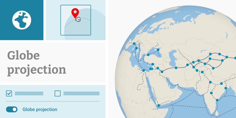
New: Globe projection in locator maps | Datawrapper Blog
Create locator maps using a globe projection
*Huge* new feature in Datawrapper! You can now create locator maps using the globe (aka orthographic) projection. Makes small scale maps so much better compared to the Mercator projection! All thanks to the amazing folks at @datawrapper.de and @maplibre.org ❤️
www.datawrapper.de/blog/new-glo...
24.07.2025 16:19 — 👍 33 🔁 10 💬 1 📌 0
![Comic. The Most-Observed Animal and Plant in Each State on iNaturalist. (Not the most common species in the state, just the one people have reported the most times.) [labeled map of the US] WA: Mallard/Western Sword Fern. OR: Mule Deer/Western Ponderosa Pine. CA: Western Fence Lizard/California Poppy. HI: Green Sea Turtle/‘Ōhi’a Lehua. ID: Mallard/Big Sagebrush. NV: Common Side-Blotched Lizard/Creosote Bush. MT: White-Tailed Deer/Common Yarrow. WY: American Bison/Sticky Geranium. UT: Mule Deer/Utah Juniper. AZ: Ornate Tree Lizard/Saguaro. CO: Mule Deer/Great Mullein. NM: Mule Deer/Creosote Bush. AK: Moose/Fireweed. ND: American Bison/Prairie Rose. SD: American Bison/Hoary Vervain. NE: American Robin/Common Milkweed. KS: Ornate Box Turtle/Amur Honeysuckle. OK: Pond Slider/Eastern Redcedar. TX: Northern Cardinal/Pinladies. MN, WI, IL: Common Eastern Bumble Bee/Common Milkweed. IA, MI: White-Tailed Deer/Common Milkweed. MO: Brown-Belted Bumble Bee/Amur Honeysuckle. AR: Three-toed Box Turtle/Chinese Privet. LA: Green Anole/Baldcypress. IN: American Robin/Amur Honeysuckle. OH: Eastern Pondhawk/Virginia Springbeauty. KY: Common Box Turtle/Amur Honeysuckle. TN: American Robin/Christmas Fern. MS: Northern Cardinal/Pale Pitcher Plant. AL: Gulf Fritillary/American Sweetgum. GA: Green Anole/American Sweetgum. FL: Brown Anole/White Beggarticks. NY: Eastern Gray Squirrel/White Snakeroot. PA: White-Tailed Deer/Garlic Mustard. WV: White-Tailed Deer/Great Rhododendron. VA: White-Tailed Deer/Eastern Poison Ivy. MD: White-Tailed Deer/Wineberry. DE: Fowler’s Toad/American Pokeweed. NC: Eastern Gray Squirrel/Christmas Fern. SC: Northern Cardinal/American Sweetgum. NJ: Spotted Lanternfly/Common Mugwort. VT: Common Eastern Bumble Bee/Eastern White Pine. NH: White-Tailed Deer/Eastern White Pine. MA: Common Eastern Bumble Bee/Eastern White Pine. CT: Common Eastern Bumble Bee/Striped Wintergreen. RI: American Herring Gull. ME: American Herring Gull/Canadian Bunchberry.](https://cdn.bsky.app/img/feed_thumbnail/plain/did:plc:cz73r7iyiqn26upot4jtjdhk/bafkreic4f56ywseq7bqc7zza3y76pxyzn5c5htebrior6jdbrfszhuiquy@jpeg)
Comic. The Most-Observed Animal and Plant in Each State on iNaturalist. (Not the most common species in the state, just the one people have reported the most times.) [labeled map of the US] WA: Mallard/Western Sword Fern. OR: Mule Deer/Western Ponderosa Pine. CA: Western Fence Lizard/California Poppy. HI: Green Sea Turtle/‘Ōhi’a Lehua. ID: Mallard/Big Sagebrush. NV: Common Side-Blotched Lizard/Creosote Bush. MT: White-Tailed Deer/Common Yarrow. WY: American Bison/Sticky Geranium. UT: Mule Deer/Utah Juniper. AZ: Ornate Tree Lizard/Saguaro. CO: Mule Deer/Great Mullein. NM: Mule Deer/Creosote Bush. AK: Moose/Fireweed. ND: American Bison/Prairie Rose. SD: American Bison/Hoary Vervain. NE: American Robin/Common Milkweed. KS: Ornate Box Turtle/Amur Honeysuckle. OK: Pond Slider/Eastern Redcedar. TX: Northern Cardinal/Pinladies. MN, WI, IL: Common Eastern Bumble Bee/Common Milkweed. IA, MI: White-Tailed Deer/Common Milkweed. MO: Brown-Belted Bumble Bee/Amur Honeysuckle. AR: Three-toed Box Turtle/Chinese Privet. LA: Green Anole/Baldcypress. IN: American Robin/Amur Honeysuckle. OH: Eastern Pondhawk/Virginia Springbeauty. KY: Common Box Turtle/Amur Honeysuckle. TN: American Robin/Christmas Fern. MS: Northern Cardinal/Pale Pitcher Plant. AL: Gulf Fritillary/American Sweetgum. GA: Green Anole/American Sweetgum. FL: Brown Anole/White Beggarticks. NY: Eastern Gray Squirrel/White Snakeroot. PA: White-Tailed Deer/Garlic Mustard. WV: White-Tailed Deer/Great Rhododendron. VA: White-Tailed Deer/Eastern Poison Ivy. MD: White-Tailed Deer/Wineberry. DE: Fowler’s Toad/American Pokeweed. NC: Eastern Gray Squirrel/Christmas Fern. SC: Northern Cardinal/American Sweetgum. NJ: Spotted Lanternfly/Common Mugwort. VT: Common Eastern Bumble Bee/Eastern White Pine. NH: White-Tailed Deer/Eastern White Pine. MA: Common Eastern Bumble Bee/Eastern White Pine. CT: Common Eastern Bumble Bee/Striped Wintergreen. RI: American Herring Gull. ME: American Herring Gull/Canadian Bunchberry.
iNaturalist Animals and Plants
xkcd.com/3118/
22.07.2025 19:52 — 👍 2131 🔁 397 💬 72 📌 96
Wild World, the Jigsaw Puzzle
I missed that a jigsaw puzzle version of Anton Thomas’s Wild World (previously) was released in January. The puzzle has 1,500 pieces and measures 39×20 inches when completed. Anton says that if you’re in the… More
I missed that a jigsaw puzzle version of Anton Thomas’s Wild World (previously) was released in January. The puzzle has 1,500 pieces and measures 39×20 inches when completed. Anton says that if you’re in the… More
21.07.2025 16:33 — 👍 0 🔁 0 💬 0 📌 0
Apple Maps Roundup
9to5Mac notes two features coming to Apple Maps as of iOS 26 this fall: natural language search and commute notifications. Meanwhile, Apple Maps briefly failed to treat Ontario’s Highway 407 as a toll road earlier… More
9to5Mac notes two features coming to Apple Maps as of iOS 26 this fall: natural language search and commute notifications. Meanwhile, Apple Maps briefly failed to treat Ontario’s Highway 407 as a toll road earlier… More
15.07.2025 14:30 — 👍 0 🔁 0 💬 0 📌 0
New Contact Page
A new contact page replaces the old contact, FAQ, link submission and review guidelines pages. Simpler and less repetitive. And instead of a contact form, there’s just an email address. So much spam was coming… More
A new contact page replaces the old contact, FAQ, link submission and review guidelines pages. Simpler and less repetitive. And instead of a contact form, there’s just an email address. So much spam was coming… More
14.07.2025 13:26 — 👍 2 🔁 0 💬 0 📌 0
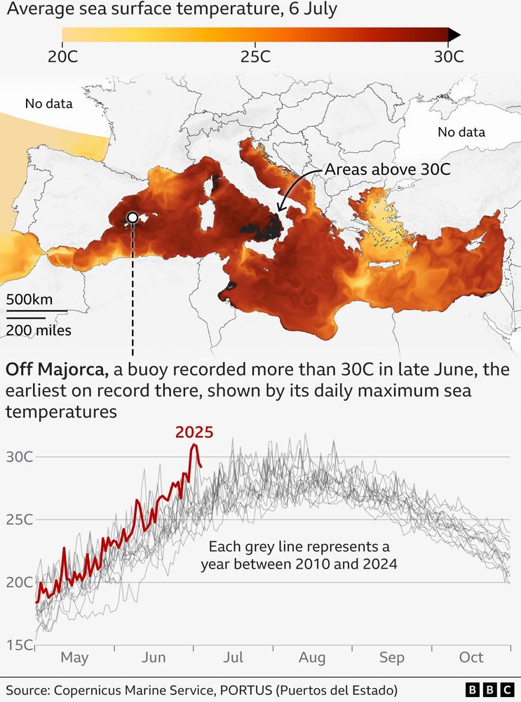
Map of sea surface temperatures in the Mediterranean Sea showing parts of it reached 30C such as off the coast of Calabria, and the islands of Majorca and Sicily. Below the map is a chart showing daily maximum temperature at a buoy next to Majorca where it reached 30C for the first time this early in the season.
Parts of the Mediterranean Sea reached 30C this week, much earlier than usual, raising fears for marine life.
For some areas, this is 6 or 7C warmer than usual at this time of year.
Our story with more maps by @markpoynting.bsky.social and me here:
www.bbc.com/news/article...
12.07.2025 09:41 — 👍 111 🔁 77 💬 3 📌 8
Maps on Vinyl in the Guardian
Damien Saunder’s book about maps on record covers, Maps on Vinyl, got a writeup in the Guardian last week. Some designs address global social or environmental issues. Others map the mind, imaginary places, feelings, worldviews—or,… More
Damien Saunder’s book about maps on record covers, Maps on Vinyl, got a writeup in the Guardian last week. Some designs address global social or environmental issues. Others map the mind, imaginary places, feelings, worldviews—or,… More
09.07.2025 13:27 — 👍 7 🔁 3 💬 0 📌 0
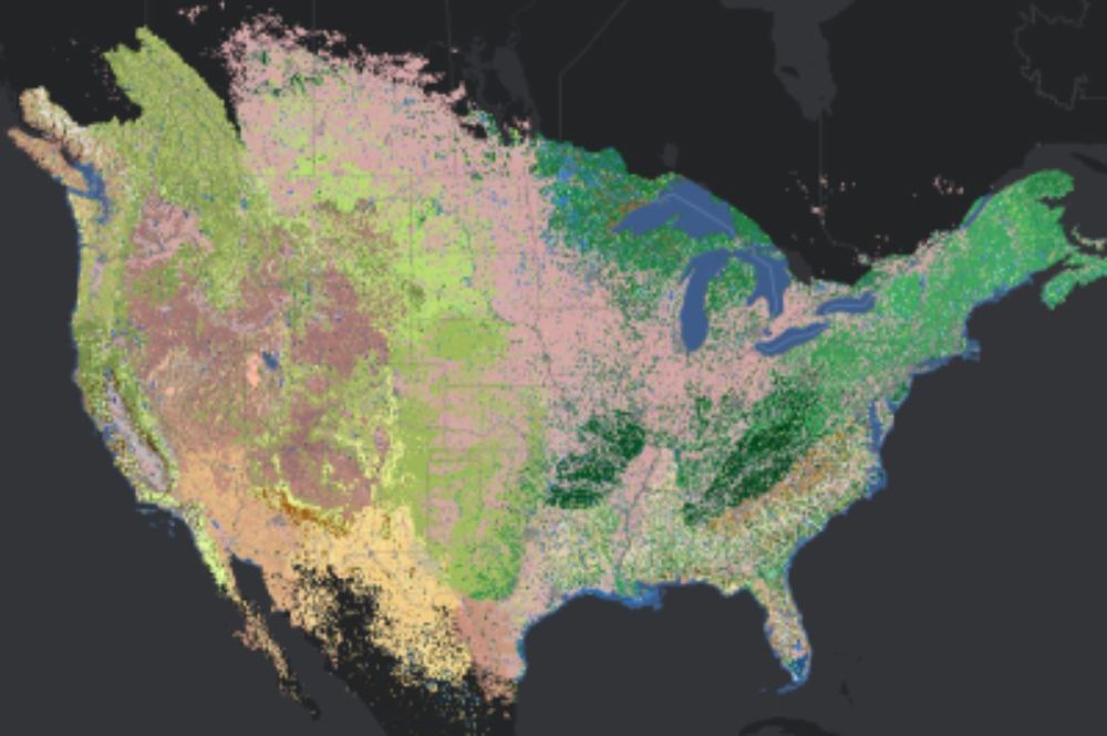
International Vegetation Classification Groups v1.0
This layer presents information on the distribution of International Vegetation Classification (IVC) Groups for North America.
Map of Ecosystems of North America Completed!
@natureserve.bsky.social has released a first-of-its-kind map of ecosystems across the conterminous U.S. & nearby regions w/ a level of detail & consistency not previously available.
🧪 🌎 #GISchat
geohub-natureserve.opendata.arcgis.com/maps/Natures...
30.06.2025 19:42 — 👍 178 🔁 69 💬 9 📌 6
Passionate about Open, Geo, Arsenal, Politics & Judaism, proud Zionist. Co-host of the Geomob Podcast, co-founder of Mappery
Mapas para entender un poco mejor el mundo // Maps to understand the world a little better
📧 Newsletter (🇪🇸): newsletter.mapasmilhaud.com
📧 Newsletter (🇬🇧): www.cartographerstale.com
🗺 Mapas / maps: mapasmilhaud.com
Geographer, hockey fan, heavy metal enthusiast, girl dad. Mostly map monster postings.
Map Curator at the Bodleian, University of Oxford; Hon Fellow, Royal Scottish Geographical Society; Chair, Charlbury Beer Festival (2020); Cyclist ...
The OG of online mapping.
Get the app on Android and iOS: lnk.bio/MapQuest
Salt Lake City, OpenStreetMap, bikepacking, Rhodes, photography (analog and digital), The Netherlands, old computers, vegetarian food, bad jokes. Old school tech guy yelling at cloud.
🌎 vanexel.net / osmutah.org / flickr.com/photos/rhodes
professor & associate chair of Slavic and Eurasian Studies at the University of Texas at Austin, dog lover, slow marathon runner, opinions mine
A @nacis.bsky.social publication dedicated to furthering the art and craft of cartography through inspirational examples.
https://atlasofdesign.org/ - Volume 7 available now!
🌈 Author, broadcaster and lecturer in design, cartography, typography and architecture around public transport. Partner of ND 🌈♾️ person. Pro-Transit 🚆 🚃 🚋 🚟🚌. In ‘transit’ from X as @markovenden.
Science Writer and Mapmaker
Senior Product Manager of Mapping & Cartography @ Esri. Previously @washingtonpost.com and National Geographic. Map-maker and geographer. portfolio: laurenctierney.com
An arboreal, poly, gender non-participant mapmaker.
• Portfolio & tutorials: somethingaboutmaps.com.
• Prints: https://somethingaboutmaps.com/Storefront
• You can support my art & teaching at http://patreon.com/pinakographos.
Do you #lovemaps? The North American Cartographic Information Society has been the home for map enthusiasts since 1980.
Use #nacis to be featured.
Learn more at nacis.org
'Peddler of Wheres,' job creator, Owner at The Map Center in Pawtucket RI- it's like a hip record store but for maps.
www.mapcenter.com
Cartographer, GIS specialist and educator
Linktr.ee/ecoandrewtrc
Data visualization consultant at the Development Data Group of the World Bank
www.maartenlambrechts.com
https://www.barelymaps.com
📍Big Island, Hawai‘i
Oakland, Maps, Bikes, etc. Also @migurski@mastodon.social and formerly @migurski on the birdsite.
A celebration of transit maps and diagrams from around the world. Visit the blog at transitmap.net. 🔁 Reposts appreciated!
Transit map prints sold at: transitmap.net/store
Transit mappers starter pack: https://go.bsky.app/32jXV41
Cartographic Editor of Maps.com & Content Strategy at Esri. Prev: DataViz Lead for NASA’s Earth Observatory. Mostly on X. Dad stuff everywhere else. Views my own.
cartographer of things
https://andywoodruff.com/