I'm strangely hungry all of a sudden...
14.07.2025 20:23 — 👍 26 🔁 0 💬 0 📌 0
![Berlin - Blickpunkt der Welt : BVG Verkehrsführer : Berlin transport guide : Berliner Verkehrs - Betrieben : nd [c.1950] : cover. A German language guide to the major streets and sights of Berlin along with a list of the city's tram, bus and underground (U-Bahn) routes. A small folder it includes various fold out pages that show in maps the BVG-West's combined tram, bus and U-Bahn routes along with a plan of the excursions possible by BVG services to Grunewald and the Havel.
Not dated the folder already shows the growing post-war division between east and west Berlin although this does show the continued extension of a few tram routes into the eastern sector before public transport routes were wholly curtailed within sectors and before the Berlin Wall was constructed.
West Berlin, unlike the East, was to abandon its extensive tramway network in the 1960s and this list shows the 21 tram still running and it was abandoned, replaced by bus A24, in 1953 so the folder pre-dates this date. I have also seen a later 1954 edition with a more modern example of Berlin's famous double deck buses on the cover so this with the older style is likely to predate this. The cover "Berlin - the focus of the world", is by Maty and the version of the U-Bahnnetz plan on the back cover is by Tesch of the BVG.
The cover shows in the background a globe, with Berlin, marked set against the city's Radio Tower - Funkturm - and a U-Bahn entrance. Highlighted in its yellow livery is one of the city's double deck bus.](https://cdn.bsky.app/img/feed_thumbnail/plain/did:plc:yqh2atawixxlb6ncx2fh73r6/bafkreian7iuxu63rcwh32mkmx7d4chvp3llwvzw2cty2srgsdj6mdfvxva@jpeg)
Berlin - Blickpunkt der Welt : BVG Verkehrsführer : Berlin transport guide : Berliner Verkehrs - Betrieben : nd [c.1950] : cover. A German language guide to the major streets and sights of Berlin along with a list of the city's tram, bus and underground (U-Bahn) routes. A small folder it includes various fold out pages that show in maps the BVG-West's combined tram, bus and U-Bahn routes along with a plan of the excursions possible by BVG services to Grunewald and the Havel.
Not dated the folder already shows the growing post-war division between east and west Berlin although this does show the continued extension of a few tram routes into the eastern sector before public transport routes were wholly curtailed within sectors and before the Berlin Wall was constructed.
West Berlin, unlike the East, was to abandon its extensive tramway network in the 1960s and this list shows the 21 tram still running and it was abandoned, replaced by bus A24, in 1953 so the folder pre-dates this date. I have also seen a later 1954 edition with a more modern example of Berlin's famous double deck buses on the cover so this with the older style is likely to predate this. The cover "Berlin - the focus of the world", is by Maty and the version of the U-Bahnnetz plan on the back cover is by Tesch of the BVG.
The cover shows in the background a globe, with Berlin, marked set against the city's Radio Tower - Funkturm - and a U-Bahn entrance. Highlighted in its yellow livery is one of the city's double deck bus.
![Berlin - Blickpunkt der Welt : BVG Verkehrsführer : Berlin transport guide : Berliner Verkehrs - Betrieben : nd [c.1950] : U-Bahnnetz und Linien. This shows the map with the lines using the older nomenclature of A I, A II, A III, B I, B II, C I, C II, D and E shown in red, green, dark blue hatching, light blue hatching and yellow. On the right the list of lines is headed by a sketch of U-Bahn train in a station.](https://cdn.bsky.app/img/feed_thumbnail/plain/did:plc:yqh2atawixxlb6ncx2fh73r6/bafkreiazuahoqvnlzsxcxmmfz4sssnhpazkygs36wtw4qwyoznpmbjpyg4@jpeg)
Berlin - Blickpunkt der Welt : BVG Verkehrsführer : Berlin transport guide : Berliner Verkehrs - Betrieben : nd [c.1950] : U-Bahnnetz und Linien. This shows the map with the lines using the older nomenclature of A I, A II, A III, B I, B II, C I, C II, D and E shown in red, green, dark blue hatching, light blue hatching and yellow. On the right the list of lines is headed by a sketch of U-Bahn train in a station.
![Berlin - Blickpunkt der Welt : BVG Verkehrsführer : Berlin transport guide : Berliner Verkehrs - Betrieben : nd [c.1950] : Linienführung der BVG - West : A German language guide to the major streets and sights of Berlin along with a list of the city's tram, bus and underground (U-Bahn) routes. A small folder it includes various fold out pages that show in maps the BVG-West's combined tram, bus and U-Bahn routes along with a plan of the excursions possible by BVG services to Grunewald and the Havel.
Not dated the folder already shows the growing post-war division between east and west Berlin although this does show the continued extension of a few tram routes into the eastern sector before public transport routes were wholly curtailed within sectors and before the Berlin Wall was constructed.
West Berlin, unlike the East, was to abandon its extensive tramway network in the 1960s and this list shows the 21 tram still running and it was abandoned, replaced by bus A24, in 1953 so the folder pre-dates this date. I have also seen a later 1954 edition with a more modern example of Berlin's famous double deck buses on the cover so this with the older style is likely to predate this. The cover "Berlin - the focus of the world", is by Maty and the version of the U-Bahnnetz plan on the back cover is by Tesch of the BVG.
The map shows tram routes in solid red lines, bus routes in red dashed lines and the U-Bahn lines imposed in black. To the west of the western sector can be seen the Grunewald in green and the Havel.](https://cdn.bsky.app/img/feed_thumbnail/plain/did:plc:yqh2atawixxlb6ncx2fh73r6/bafkreidq6svbvpoexkfdjcjyrlifmfiekkavnumsyrwm7ojosfbspvpyia@jpeg)
Berlin - Blickpunkt der Welt : BVG Verkehrsführer : Berlin transport guide : Berliner Verkehrs - Betrieben : nd [c.1950] : Linienführung der BVG - West : A German language guide to the major streets and sights of Berlin along with a list of the city's tram, bus and underground (U-Bahn) routes. A small folder it includes various fold out pages that show in maps the BVG-West's combined tram, bus and U-Bahn routes along with a plan of the excursions possible by BVG services to Grunewald and the Havel.
Not dated the folder already shows the growing post-war division between east and west Berlin although this does show the continued extension of a few tram routes into the eastern sector before public transport routes were wholly curtailed within sectors and before the Berlin Wall was constructed.
West Berlin, unlike the East, was to abandon its extensive tramway network in the 1960s and this list shows the 21 tram still running and it was abandoned, replaced by bus A24, in 1953 so the folder pre-dates this date. I have also seen a later 1954 edition with a more modern example of Berlin's famous double deck buses on the cover so this with the older style is likely to predate this. The cover "Berlin - the focus of the world", is by Maty and the version of the U-Bahnnetz plan on the back cover is by Tesch of the BVG.
The map shows tram routes in solid red lines, bus routes in red dashed lines and the U-Bahn lines imposed in black. To the west of the western sector can be seen the Grunewald in green and the Havel.
Berlin - Blickpunkt der Welt : c.1950 Berlin BVG West transport guide - detailing the city's tram, bus & U-Bahn system before the Western sector scrapped its tramway system. #transport #Berlin #Germany #maps @transitmap.net @stephenbln.bsky.social
↘️ flic.kr/p/2rgtnZL
14.07.2025 11:15 — 👍 15 🔁 4 💬 0 📌 0
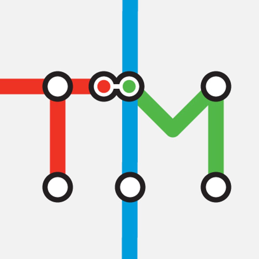
A small indication of the amount of work that goes on behind the scenes before we even *see* a transit diagram!
(Also, I low-key have a crush on that hypothetical built-out system map)
09.07.2025 20:39 — 👍 8 🔁 2 💬 1 📌 0
Ah, I was wondering if it was a CHK America map - thanks for the confirmation!
09.07.2025 16:08 — 👍 2 🔁 0 💬 0 📌 0
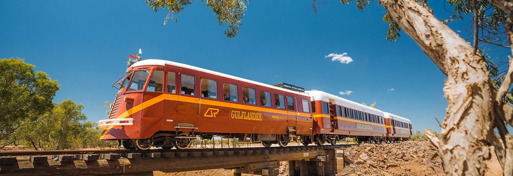
Pretty much – a railroad from "nowhere to nowhere" disconnected from the rest of the network (and always has been) and running some vintage railbus rolling stock – see photo. The line itself dates as far back as 1888.
www.gulflander.com.au
02.07.2025 21:48 — 👍 1 🔁 0 💬 0 📌 0
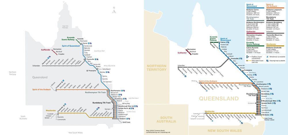
They absolutely exist and you can ride them today!
www.queenslandrailtravel.com.au
02.07.2025 20:36 — 👍 1 🔁 0 💬 1 📌 0
And here's a side-by-side comparison of the two different approaches to this design problem. Mine is on the right, just in case that wasn't clear :-)
02.07.2025 20:03 — 👍 17 🔁 2 💬 2 📌 0
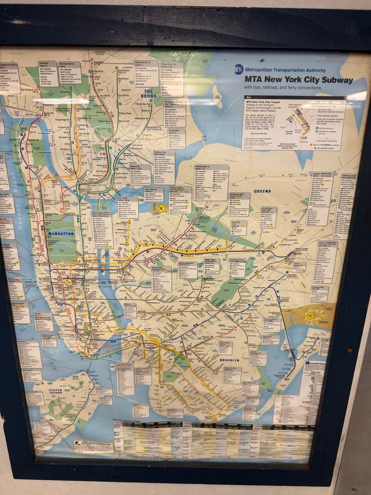
Kind of amazed that this 17-year old subway map remains untouched on the S.I. Newhouse ferry.
27.06.2025 00:15 — 👍 39 🔁 2 💬 5 📌 1
I have seen good ones… but this is not one of them.
02.07.2025 01:36 — 👍 1 🔁 0 💬 0 📌 0
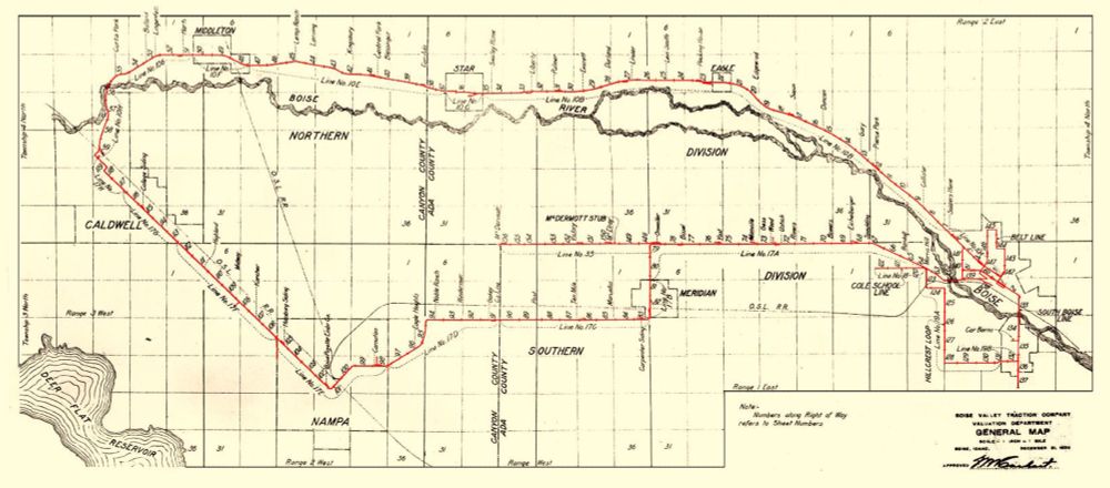
Meanwhile, 100 years ago... yep, that's a 70-mile electric interurban loop running through Boise, Caldwell, Meridian, Nampa and Eagle, plus city streetcars in Boise itself.
01.07.2025 23:48 — 👍 17 🔁 0 💬 0 📌 0
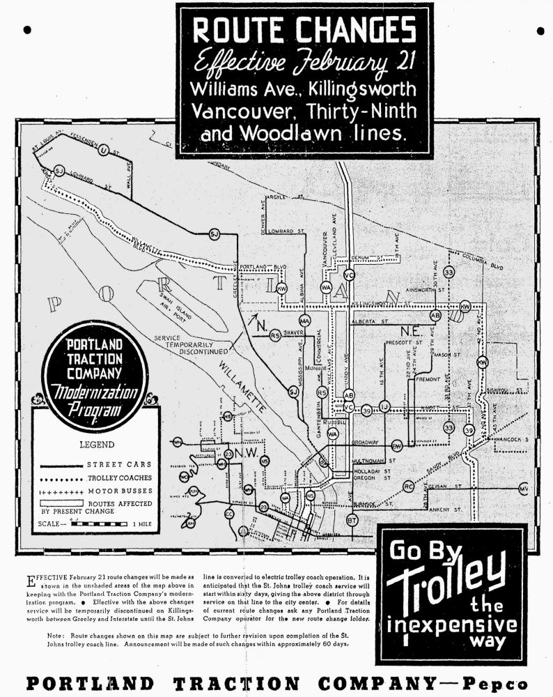
Route Changes Effective February 21, 1937: Williams Ave., Killingsworth, Vancouver, Thirty-Ninth and Woodlawn Lines.
---
Effective February 21 route changes will be made as shown in the unshaded areas of the map above in keeping with the Portland Traction Company’s modernization program.
Effective with the above changes service will be temporarily discontinued on Killingsworth between Greeley and Interstate until the St. Johns line is converted to electric trolley coach operation. It is anticipated that St. Johns trolley coach service will start within sixty days, giving the above district through service on that line to the city center.
For details of current route changes ask any Portland Traction Company operator for the new route change folder.
Note: Route changes shown on this map are subject to further revision upon completion of the St. Johns trolley coach line. Announcement will be made of of such changes within approximately 60 days.
Newspaper ad from February 1937 showing route changes being made as part of the Portland Traction Company's modernization program. The Williams Avenue and Woodlawn streetcar lines were abandoned at this time, and several others only had a few more months of existence.
(Ad copy in alt text)
29.06.2025 20:38 — 👍 20 🔁 3 💬 0 📌 1
15% off today and tomorrow only – get your transit map prints now!
30.06.2025 00:33 — 👍 4 🔁 0 💬 0 📌 0
The maps I have in my store are based on what high-quality scans I can obtain. There are a few variations of this Sydney tram map from different years (all showing the same area) – the 1905 one just has the best print quality. I haven't come across a good scan showing the network at its zenith.
29.06.2025 16:33 — 👍 0 🔁 0 💬 0 📌 0
Flash sale – 15% off all prints in the store through the end of the month! Discount taken automatically. Original designs and vintage reproductions.
transitmap.net/store/prints/
28.06.2025 00:30 — 👍 16 🔁 2 💬 2 📌 1
Two of my absolute faves - you’re gonna love them!
28.06.2025 03:43 — 👍 1 🔁 0 💬 0 📌 0
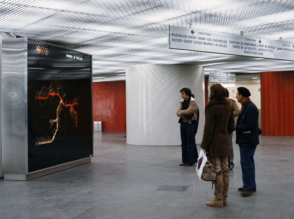
Les archives de la RATP la gare de Châtelet Les Halles en 1977 Arrivée du RER A à Noisy le Grand en 1977, la prolongation à Torcy se fera en 1980. Arrivée du RER B à Châtelet en 1977, la prolongation à Gare du Nord se fera en 1982.
08.06.2025 10:09 — 👍 23 🔁 6 💬 3 📌 3
Flash sale – 15% off all prints in the store through the end of the month! Discount taken automatically. Original designs and vintage reproductions.
transitmap.net/store/prints/
28.06.2025 00:30 — 👍 16 🔁 2 💬 2 📌 1
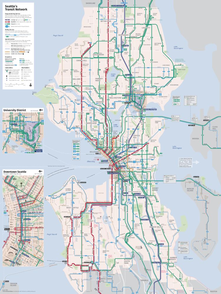
June 2025 edition of Seattle Transit Map
After over a year of neglect, I finally updated my Seattle Transit Map! September will mark the tenth anniversary of the map. The website itself needs work but the new layer is now online. seattletransitmap.com/app/
22.06.2025 18:02 — 👍 218 🔁 39 💬 15 📌 3
Next Pixar movie: "What if infographics were people?"
09.05.2025 00:09 — 👍 2 🔁 0 💬 0 📌 0
Two ideas for this: if I see it as a supporting service for the City of New Orleans, I could give it a color that's related to the orange of that route, maybe darken it up to a mid-brown. OR I could just go for something that provides good visual contrast between the two lines, like a dark blue.
07.05.2025 16:51 — 👍 1 🔁 0 💬 0 📌 0
Yep! There’s a legend on the full map that clearly explains this
07.05.2025 15:16 — 👍 1 🔁 0 💬 0 📌 0
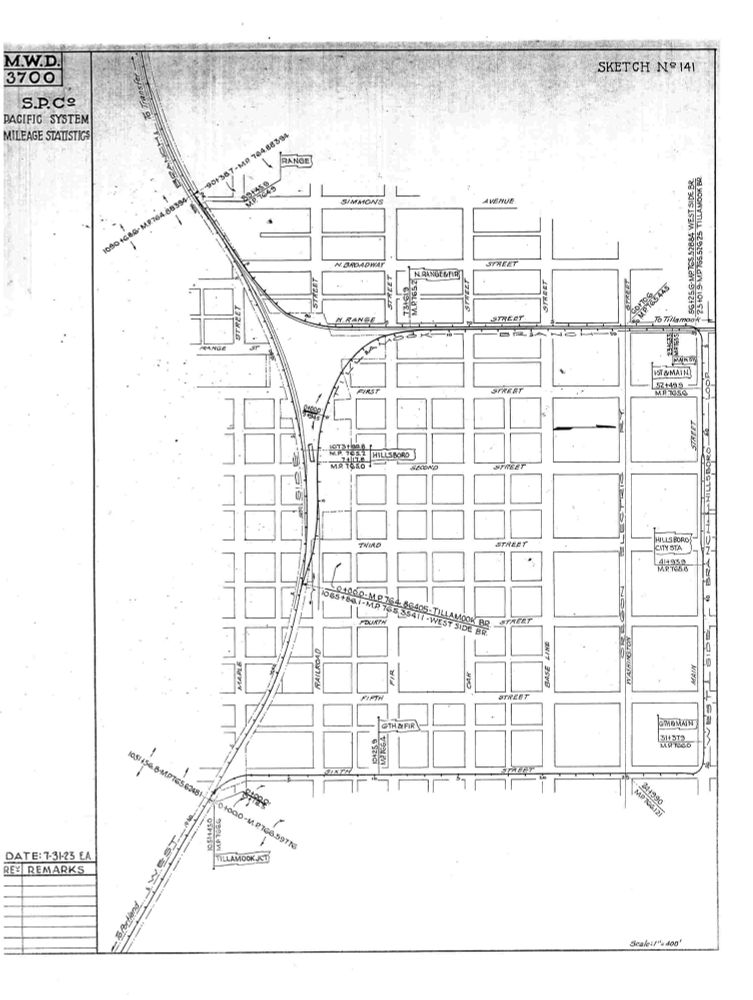
Southern Pacific junction sketch No. 141 from 1923 showing the Hillsboro city loop that the interurban "Red Electric" cars used along Sixth, Main and Range streets. The main ticket office and waiting room was at Main and Third. Love the little flags for station names!
05.05.2025 15:58 — 👍 19 🔁 3 💬 0 📌 1
mostly transit talk // executive director @caltransit // alum of @goldmanschool @berkeleyecon // former @jerrybrowngov @cahsra // LA native living in NorCal 🇲🇽
// opinions = my own
Transit nerd, traveler, marketer, onetime Rhode Islander, longtime New Yorker, that guy alone on the plane that one time
Beer content is at @brewyork.beer
brewyork.substack.com
📍Brooklyn, NY
Using data and remastered historic photography to document the destruction of communities of color by redlining, urban renewal, freeways, and disinvestment; also highlighting solutions https://www.segregationbydesign.com/
Director of Transportation Choices Coalition | Not short for Kirkleton
'Peddler of Wheres,' job creator, Owner at The Map Center in Pawtucket RI- it's like a hip record store but for maps.
www.mapcenter.com
Cartographer, GIS specialist and educator
Linktr.ee/ecoandrewtrc
Historian, geographer, part of #Railway200 team, presenter @UKTV’s #TheArchitectureTheRailwaysBuilt & #SecretsOfTheLondonUnderground, Trainspotter, 🏳️🌈, and always an enthusiast. Own views, obv.
I make posts about making videos about making maps about stuff.
Transport analysis for London and occasionally beyond.
Ex-London Underground and retired back to "The North" - transport, design history, things industrial, architecture & heritage - all tickle my fancy. Postings often link to my Flickr account for more things!
Fell in love with the tube map as a youngster in London - love the thrill of designing rail diagrams. https://projectmapping.co.uk
Shop for printed maps at: http://redbubble.com/people/MrMappy…
A companion account for the "Portland Streetcar History" research wiki curated by Cameron Booth. Lots of photos, maps, remnants, and research musings.
Visit the wiki at: https://bit.ly/pdxstreetcars
Railway engineer and author of HOW THE RAILWAYS WILL FIX THE FUTURE (https://bit.ly/HowTheRailways). Hosts @railnatter.uk. Chairs Yorkshire PWI and NEREF. Co-founder of the Campaign for Level Boarding. He/him.
‘THIS WAY UP - When Maps Go Wrong’
Pre-order the MAP MEN BOOK now! 🗺️ 📖
https://lnk.to/mapmen
East End blogger bloke (2002-2025) diamondgeezer.blogspot.com
Author & photographer Luke Agbaimoni's project capturing stations & stops on the London Underground tube map.
Tubemapper.com
💰 Book,Prints & Calendars
✉ luke@tubemapper.com
DM for info
Author of Straphanger | Words NY Times Nat Geo Smithsonian WSJ | Latest book Lost Supper | Talks: http://taras-grescoe.com/contact
https://www.highspeed.blog (Transit, trains, bikes)
https://linktr.ee/tarasgrescoe
Agent: www.skagency.com
We keep the Portland region moving. Visit http://trimet.org/alerts for service info. Call or text 503-238-7433 for customer service.
Cartography and graphics for the Washington Post @postgraphics.bsky.social | Big ol' fan of @wfmu.bsky.social
https://moriartymaps.com/