Great site, thank you. It will be interesting to see what happens if indeed there is an El niño onset JJA.
07.02.2026 16:27 — 👍 2 🔁 0 💬 0 📌 0
Rain has arrived #YVR. Plume extnds well SW of HI. Luckily it drops S fairly quickly, followed by decreasing temps aloft in a SW flow as an upr low 49N 152 W sloly shifts E. So rain tdy, tapering PM. Some clrg ovnite w/areas AM fg Sun then partial sun. Mon/Tue unsettled/shwry. 🌞 Wed. 🌧️/wind Thu
07.02.2026 14:44 — 👍 17 🔁 1 💬 2 📌 0
Maybe!
07.02.2026 14:03 — 👍 1 🔁 0 💬 0 📌 0
You have to wonder: at what point to we hit the cliff?
07.02.2026 04:23 — 👍 1 🔁 0 💬 1 📌 0

Cooler yes, alpine snow, probably. For the lowlands the problem is the pattern. It's forecasting a trough with westerly flow over SWBC. We need flow from the N.
07.02.2026 02:20 — 👍 0 🔁 0 💬 0 📌 0
Too far in the future to be useful guidance
06.02.2026 23:41 — 👍 1 🔁 0 💬 2 📌 0
Fast line of ACC on radar, moving with the wind aloft. Dry beneath the clouds so should just be a virga producer or just a few drops
06.02.2026 23:35 — 👍 9 🔁 0 💬 1 📌 0
And yet the AO forecast is neutral to slightly positive. That would mean the cold air is likelier to stay bottled up to the N. We shall see. Clock is ticking...
06.02.2026 16:09 — 👍 2 🔁 0 💬 0 📌 0
PNA tells you about the flow tendency/pattern, but not much in terms of weather details. What it is well correlated with is more frequent coast-crossing disturbances in an enhanced zonal (more E-W than N-S) jetstream and an overall coastal mean upper trough, so cooler. So tends to wetter/cooler
06.02.2026 16:05 — 👍 2 🔁 0 💬 1 📌 0

The edge of some mid cloud approaches #YVR but enjoy what will be a lovely spring-like day before our return to the usual dismal pattern tomorrow
06.02.2026 15:35 — 👍 17 🔁 1 💬 2 📌 0
Not really in the back country. Weak crust with high break-thru potential. On the groomed sfcs it was slush yesterday. But a chance to ski at 16C in Feb? Priceless :)
06.02.2026 15:31 — 👍 2 🔁 0 💬 0 📌 0
Vrbl skies tdy #YVR as a weak upr trough to the N drags thru SW flow aloft. Next plume of subtrop moisture to the SW lands on SWBC ovnite w/rain taperg to shwrs Sat PM as the plume slumps to the S. Thereafter, flow cools as a major upr low 48N 154 W shifts E. Vrbl skies Sun. Unsettled/cooler Mon-Thu
06.02.2026 15:28 — 👍 16 🔁 2 💬 2 📌 0
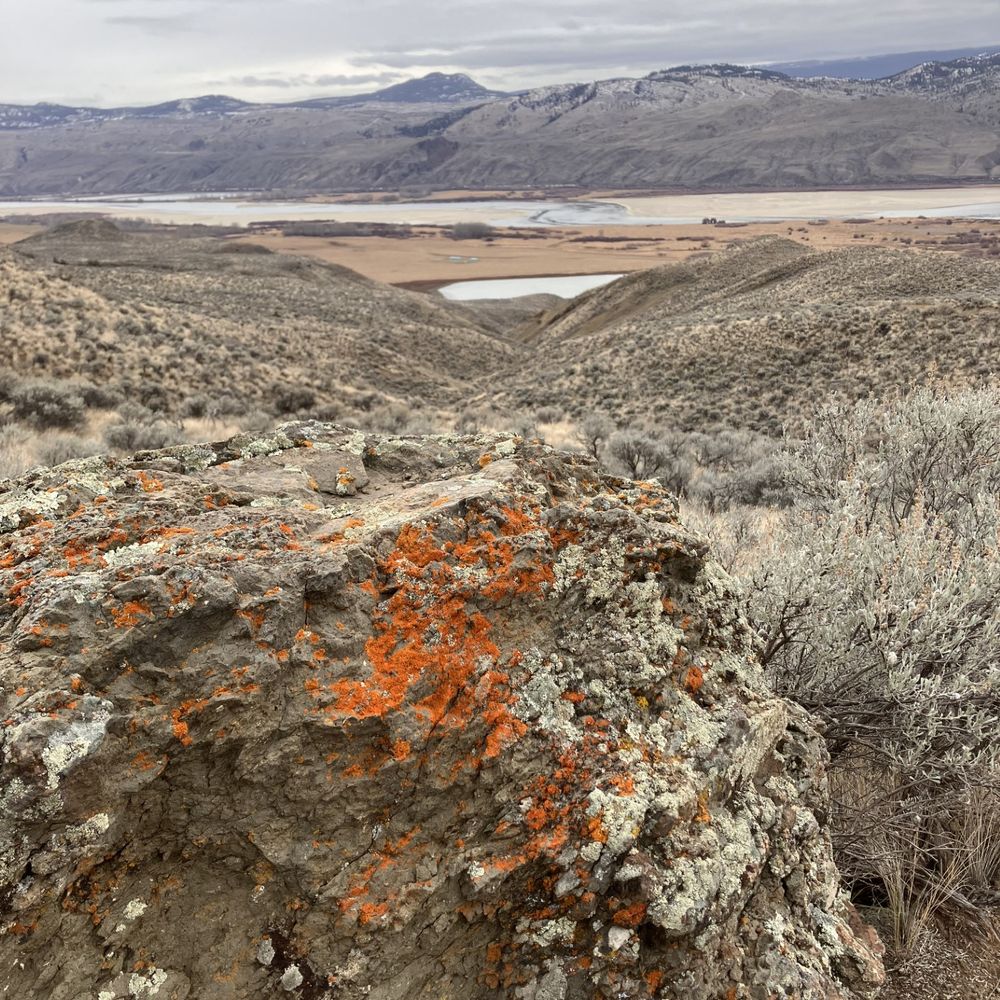
The smooth and surreal snow surface is the result of recent rain on snow events
06.02.2026 01:03 — 👍 12 🔁 1 💬 0 📌 0

View from near the summit of Pump Peak Mt Seymour Park today. In spite of the snow cover it was def T-shirt weather up there
06.02.2026 01:00 — 👍 22 🔁 1 💬 4 📌 0
In a well mixed early summer atmosphere, the high in Squamish today would be near 30C.
05.02.2026 14:48 — 👍 2 🔁 0 💬 1 📌 0
🔥!
05.02.2026 14:46 — 👍 1 🔁 0 💬 0 📌 0

Closest sounding to #YVR indicates a very warm Alpine today. 20C this AM at 400 m above Quillayute WA. Expect mid teems N Shore peaks this PM.
05.02.2026 13:19 — 👍 14 🔁 1 💬 1 📌 0
Patchy fog inland this AM #YVR; more xtensiv cst. Bcmg mainly 🌞 tdy w/a few mid clds movg around an upr rdg centred ovr NE NV. Mild. Rdg retreats Fri; mainly cldy. Wv in a moist SW flow hits the cst Sat for hvy rain taperg to shwrs Sun. Shwrs, cooler Mon. Unsettled/breezy/cool thru nxt wk. Alpine ❄️
05.02.2026 13:16 — 👍 17 🔁 1 💬 1 📌 0
Look for the light blue lines that don’t move with the animation. Those are boundaries and coastlines
05.02.2026 01:08 — 👍 0 🔁 0 💬 0 📌 0

Pretty nice day #YVR. Hope you could get outside.
05.02.2026 01:00 — 👍 15 🔁 0 💬 3 📌 0
Just wow. Perfecto!
04.02.2026 17:53 — 👍 2 🔁 0 💬 0 📌 0
Night time lows sure have been mild...
04.02.2026 15:58 — 👍 0 🔁 0 💬 1 📌 0
That's what it looks like but don't trust any details beyond a week.
04.02.2026 15:57 — 👍 1 🔁 0 💬 2 📌 0
Let's hope so. We need snow.
04.02.2026 15:31 — 👍 4 🔁 0 💬 1 📌 0

Atmospheric Dynamics. - AO since late Dec and +PNA since early Jan. +PNA generally means more blocking to the south, pushing the storm track NW toward Alaska, w/an increased chance of cooler, drier periods unless another forcing (e.g., –AO) disrupts the ridge. Which it has periodically.
04.02.2026 15:20 — 👍 3 🔁 0 💬 1 📌 0
SWBC undr a vry mild SW flow aloft. Abv a shallow inversion, dry up to 500 mb (6 km). Vrbl hi/mid cld tdy; vry mild #YVR. Fog likely Thu AM as skies clr ovnite undr a bldg upr rdg then mainly sunny. Areas AM fog Fri. Clds slowly increase PM. Rain Sat taperg to shwrs Sun. Some clrg/cooler Mon/Tue
04.02.2026 15:06 — 👍 17 🔁 2 💬 3 📌 0
Yes, but it's still within a westerly which is good for alpine snow prospects but not so good for sea level snow
03.02.2026 20:51 — 👍 3 🔁 0 💬 2 📌 0
Noticeably unusual is that the Rex block (an upper ridge/high over an upper trough/low) influencing SWBC weather thru the rest of this work week is btn a high over the USSW and a low off Baja CA MX
03.02.2026 14:11 — 👍 11 🔁 1 💬 0 📌 0
Deep sfc/upr low to the W (48N 160W) w/an upr ridge xtendng N alg the cst this AM, and a rich NNE-SSW plume of moisture btn them. The W coast rdg is Rex blocked thru Fri. Vrbl skies tdy-Wed #YVR. Chc shwr this eve. Mild. More sun Thu w/chc AM fg. Clds + Fri PM, Rain Sat, and a coolng trend starts
03.02.2026 14:03 — 👍 17 🔁 1 💬 1 📌 0
http://www.metmaps.info
No games. Just weather.
MetMaps ist eine Businessanwendung zur Darstellung und Auswertung meteorologischer Daten.
Astronomer, driving The Dish📡 to study pulsars in my PhD. Also, founded SpaceAustralia.com. Also, love a bit of astrophotography. Also, do everything with my little mate, Max. Also, Ultra-Gay. He/Him.
Microbiologist. Scientist ignored. In the mountains and not coming out.
Atmospheric Scientist. Former Adjunct Associate Professor and Research Scientist, School of Meteorology, University of Oklahoma. LES, dust devils on Earth and Mars, supercells, tornadoes, mammatus, hail, and cloud physics.
A 24/7 live stream webcam on YouTube featuring expansive harbour and city views. Subscribe to my channel for the latest in scenic views!
https://youtube.com/@vancouverportlive?si=DulLnRT4YExF09Su
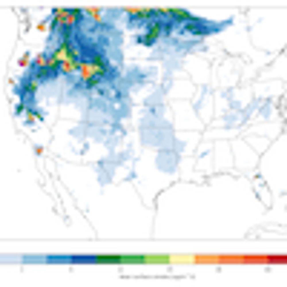
This bot will post an updated forecast animation every 3 hours.
The bot downloads NOAA forecast data and plots it as-is. No further processing is done on the data.
See https://envismo.social/@noaa_hrrr_smoke_forecast_bot for more details
Environmentalist and entrepreneur. Co-founded Emergent Waste Solutions as a vehicle to fight climate change through technology.
Please don't DM me unless we already know each other, or you are interested in Thermolysis technology.
Biologist and science/environment/adventure travel writer for Canadian Geographic and others, tracking the intersecting climate and biodiversity crises; my books stray into fields like herpetology, invasive species and... skiing (weird, eh?).
Climate change ~ Clean air ~ Clean water ~ Convening for change
Unceded Syilx territory
He/him
Freelance Radio/TV/Digital Producer • Photographer | #StarWars • #Apple • #NHL • #Canucks -lifer | Kindness is power— so is a killer slapshot 🏒🇨🇦
Research Meteorologist/Developer. OU alum (PhD/MS). I study precipitation, microphysics, polarimetric radar, and tropical cyclones. Opinions = my own.
The same @capital_climate you've known and loved since 2010 at The Other Place.
Climate scientist, physicist, mathematician, educator.
Chief Meteorologist WDEF News 12, Chattanooga TN;
science journalist, emergency communications, consultancy available. Amateur Radio KG4GKE, #RockChalkJayhawk
https://austenonek.home.blog/
AirlineFlyer. From Twitter.
Airlines, airplanes, trains, transit, travel. #AvGeek co-host of Flightradar24's AvTalk podcast. https://www.flightradar24.com/blog/avtalk-podcast/
email: jason@airlineflyer.net
Meteorologist. Started Canada’s hurricane research and forecast program. Past-President CMOS: https://www.cmos.ca/site/about/cmos?nav=sidebar
Born 314ppm CO2; we're now 425ppm!
Prime Minister of Canada and Leader of the Liberal Party | Premier ministre du Canada et chef du Parti libéral
markcarney.ca
Who owns the economy matters. We're a policy nonprofit working on changing the rules of the economy so more people can own assets and build wealth. #cdnpoli #ownershipmatters www.socialcapitalpartners.ca Toronto, ON 🇨🇦