United: San Francisco - Kauai, Hawaii (and vice versa). $237 (Basic Economy) / $337 (Regular Economy). Roundtrip, including all Taxes | #travel
For more info: www.theflightdeal.com/b/1P9i .

@inflightout.bsky.social
🌪 🌈 🔥✈️ 🚨❄️#StormChaser #EmergencyManagement #Fitness #Libtard #LGBT #LeftCoast #Travel #PublicHealth
United: San Francisco - Kauai, Hawaii (and vice versa). $237 (Basic Economy) / $337 (Regular Economy). Roundtrip, including all Taxes | #travel
For more info: www.theflightdeal.com/b/1P9i .

SUMMER: Non-stop from #SanFrancisco to #LasVegas (& vice versa) for only $77 roundtrip with United Airlines #Travel
www.secretflying.com/posts/summer...
 12.07.2025 23:15 — 👍 15 🔁 7 💬 0 📌 0
beautiful read. thank you
12.07.2025 13:21 — 👍 0 🔁 0 💬 0 📌 0Musk didn’t start a new party. He wrote a tweet.
05.07.2025 22:51 — 👍 1275 🔁 145 💬 18 📌 23is that bad? that sounds bad
22.04.2025 12:58 — 👍 71 🔁 18 💬 4 📌 1This screenshot is the smoking gun.
The Defense Secretary—on Signal—live texting classified strike times to people without the proper clearance.
Hegseth’s defense? Blame a “disgruntled employee” and bash the media. And the White House is still standing by him.
1/2
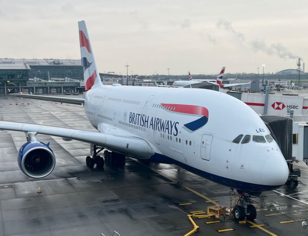
Tragic: British Airways Flight Attendant Found Dead During SFO Layover
onemileatatime.com/news/british...
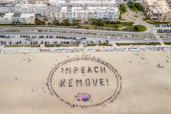
Very creative, San Francisco! 8647 ✊
19.04.2025 20:55 — 👍 35708 🔁 6323 💬 279 📌 202
Cathay Pacific: San Francisco - Bali, Indonesia. $832. Roundtrip, including all Taxes | #travel
For more info: www.theflightdeal.com/b/1Meu .

10 Lessons for Stronger Movements. Imperfect Allies Aren’t Enemies; Critique to Build, Not Tear Down; Organize, Don’t Just Argue; Movements Win, Not Individuals; Perfection Is the Enemy of Progress; Ego Kills Movements; Plan for the Long Game; Meet People Where They Are; Power Doesn’t Care About Feelings; Division Is a Weapon Used By Elites, Don’t Play Along
If we are going to get our country back, we need to keep this in mind. We don’t have the luxury of not engaging w/ or accepting help from imperfect allies. If they want in on this fight, let’s welcome them! The other 9 lessons are important, too. If we are mindful of this ⬇ we will be stronger.
18.04.2025 22:29 — 👍 276 🔁 115 💬 11 📌 9
The #weather app you use relies on data collected by #NOAA from radar, satellites, its weather balloons, surface stations, ocean buoys, & more. If NOAA can’t operate at its usual levels, its #forecasts may be less accurate, endangering all of us.
www.rollingstone.com/politics/pol... #EM #USwx #NWS
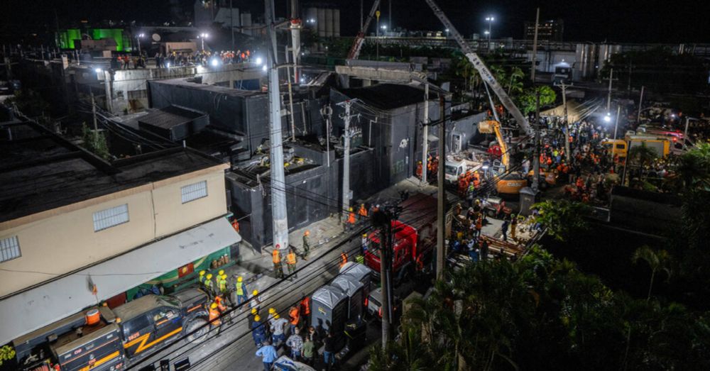
Hopes of finding more survivors in the fatal roof collapse of a nightclub in the Dominican Republic began to fade on Wednesday, as the authorities acknowledged that they had not found anyone alive in the rubble since Tuesday afternoon. At least 113 people have died, an official said.
09.04.2025 12:04 — 👍 102 🔁 15 💬 7 📌 3You may be fearing your 401k is no longer enough for you to retire. But with all the cuts to NIH and Medicare you also won't live as long. So the policies are integrated.
07.04.2025 01:20 — 👍 34281 🔁 7345 💬 832 📌 497
Makes ya think
05.04.2025 12:27 — 👍 8837 🔁 1599 💬 219 📌 75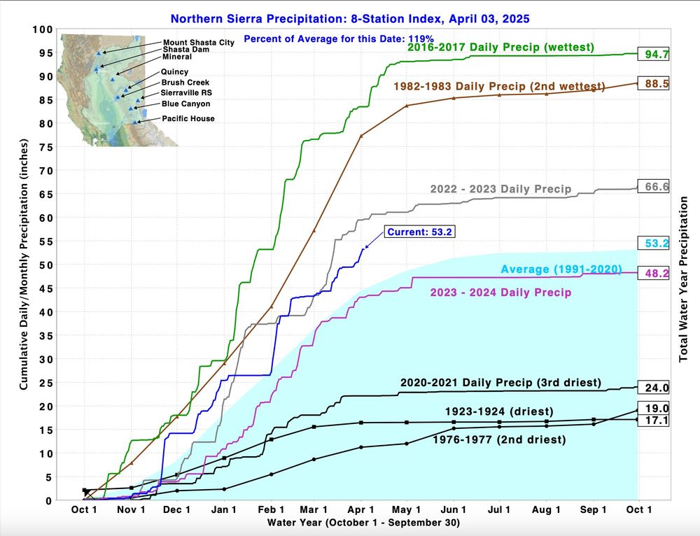
It's been a good year for precipitation in the Northern Sierra, a key region for California's water supply. Most of the year, the totals have been above average for the date. The current total matches the average for the entire water year, which runs through Sept. 30. #CAwx
03.04.2025 17:50 — 👍 18 🔁 3 💬 0 📌 0
WATCH vs. WARNING Taco watch - pile of ingredients Taco warning - tacos are made and ready to eat
#tacos
03.04.2025 18:14 — 👍 17 🔁 7 💬 2 📌 0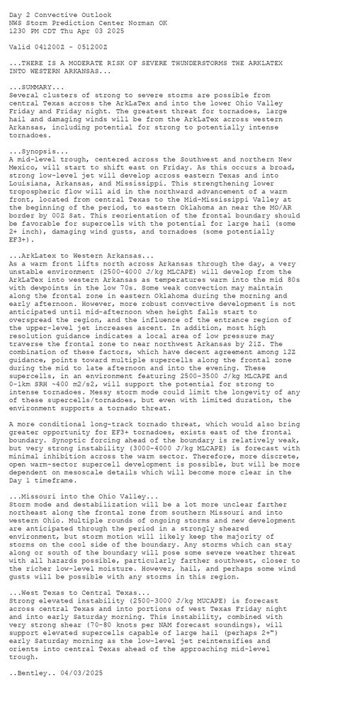
Day 2 Convective Outlook NWS Storm Prediction Center Norman OK 1230 PM CDT Thu Apr 03 2025 Valid 041200Z - 051200Z ...THERE IS A MODERATE RISK OF SEVERE THUNDERSTORMS THE ARKLATEX INTO WESTERN ARKANSAS... ...SUMMARY... Several clusters of strong to severe storms are possible from central Texas across the ArkLaTex and into the lower Ohio Valley Friday and Friday night. The greatest threat for tornadoes, large hail and damaging winds will be from the ArkLaTex across western Arkansas, including potential for strong to potentially intense tornadoes. ...Synopsis... A mid-level trough, centered across the Southwest and northern New Mexico, will start to shift east on Friday. As this occurs a broad, strong low-level jet will develop across eastern Texas and into Louisiana, Arkansas, and Mississippi. This strengthening lower tropospheric flow will aid in the northward advancement of a warm front, located from central Texas to the Mid-Mississippi Valley at the beginning of the period, to eastern Oklahoma an near the MO/AR border by 00Z Sat. This reorientation of the frontal boundary should be favorable for supercells with the potential for large hail (some 2+ inch), damaging wind gusts, and tornadoes (some potentially EF3+). ...ArkLatex to Western Arkansas... As a warm front lifts north across Arkansas through the day, a very unstable environment (2500-4000 J/kg MLCAPE) will develop from the ArkLaTex into western Arkansas as temperatures warm into the mid 80s with dewpoints in the low 70s. Some weak convection may maintain along the frontal zone in eastern Oklahoma during the morning and early afternoon. However, more robust convective development is not anticipated until mid-afternoon when height falls start to overspread the region, and the influence of the entrance region of the upper-level jet increases ascent. In addition, most high resolution guidance indicates a local area of low pressure may traverse the frontal zone to near northwest Arkansas by 21Z. The combination of these factors, which have decent agreement among 12Z guidance, points toward multiple supercells along the frontal zone during the mid to late afternoon and into the evening. These supercells, in an environment featuring 2500-3500 J/kg MLCAPE and 0-1km SRH ~400 m2/s2, will support the potential for strong to intense tornadoes. Messy storm mode could limit the longevity of any of these supercells/tornadoes, but even with limited duration, the environment supports a tornado threat. A more conditional long-track tornado threat, which would also bring greater opportunity for EF3+ tornadoes, exists east of the frontal boundary. Synoptic forcing ahead of the boundary is relatively weak, but very strong instability (3000-4000 J/kg MLCAPE) is forecast with minimal inhibition across the warm sector. Therefore, more discrete, open warm-sector supercell development is possible, but will be more dependent on mesoscale details which will become more clear in the Day 1 timeframe. ...Missouri into the Ohio Valley... Storm mode and destabilization will be a lot more unclear farther northeast along the frontal zone from southern Missouri and into western Ohio. Multiple rounds of ongoing storms and new development are anticipated through the period in a strongly sheared environment, but storm motion will likely keep the majority of storms on the cool side of the boundary. Any storms which can stay along or south of the boundary will pose some severe weather threat with all hazards possible, particularly farther southwest, closer to the richer low-level moisture. However, hail, and perhaps some wind gusts will be possible with any storms in this region. ...West Texas to Central Texas... Strong elevated instability (2500-3000 J/kg MUCAPE) is forecast across central Texas and into portions of west Texas Friday night and into early Saturday morning. This instability, combined with very strong shear (70-80 knots per NAM forecast soundings), will support elevated supercells capable of large hail (perhaps 2+") early Saturday morning as the low-level jet reintensifies and orients into central Texas ahead of the approaching mid-level trough. ..Bentley.. 04/03/2025
Day 2 Outlook Image
SPC Apr 3, 2025 1730 UTC Day 2 Convective Outlook
⛈️THERE IS A MODERATE RISK OF SEVERE THUNDERSTORMS THE ARKLATEX
INTO WESTERN ARKANSAS🌪️
Additional Details Here.
US Convective Outlook graphic
US Tornado Outlook graphic
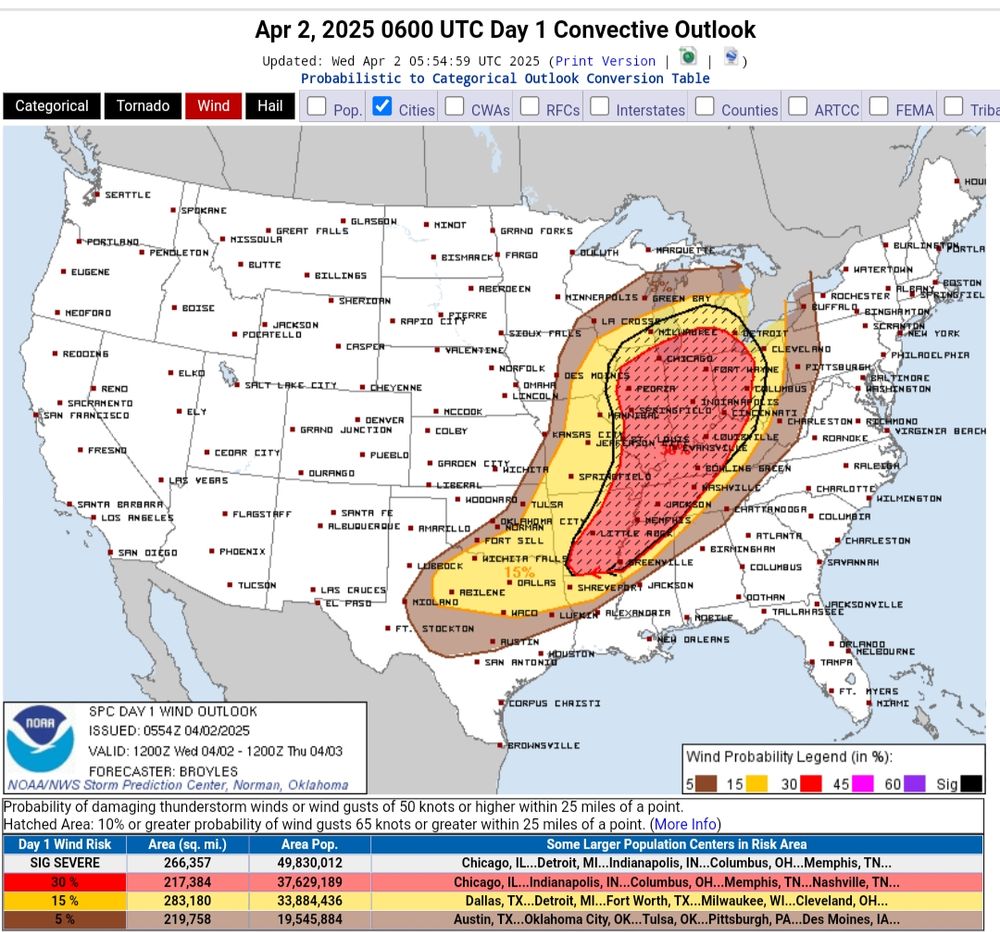
US Wind Outlook graphic
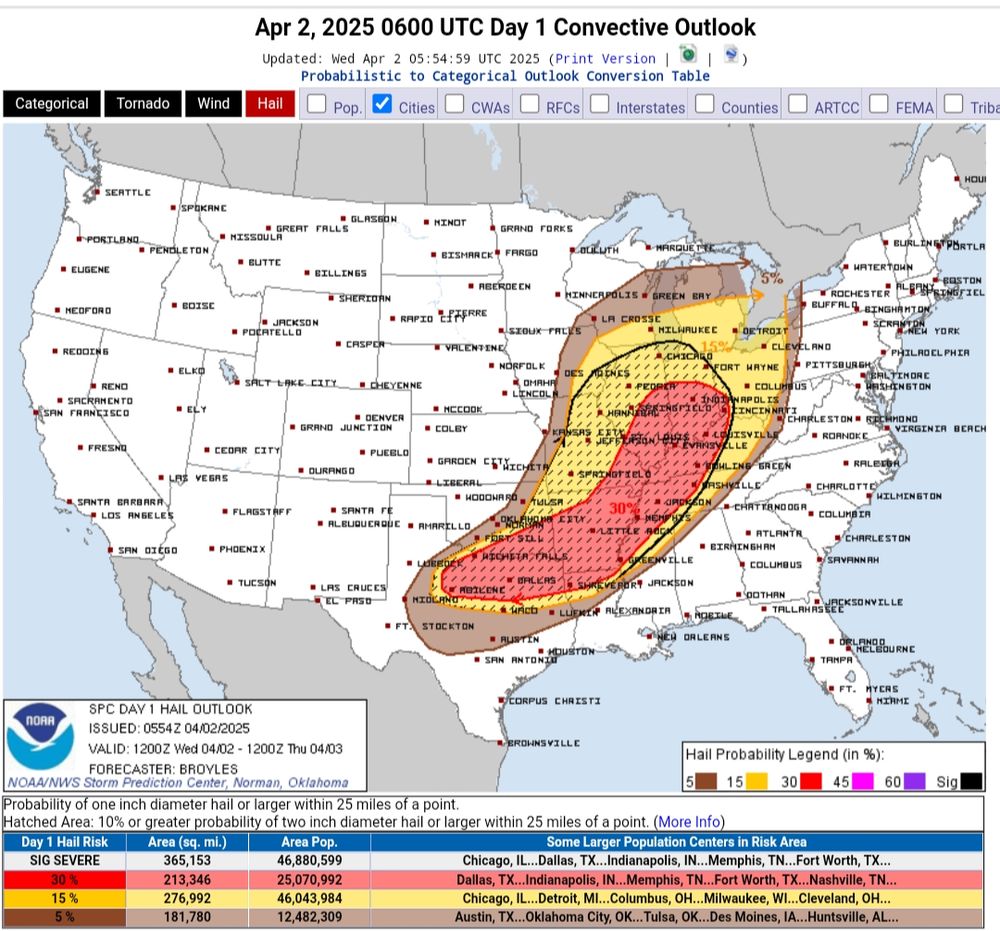
US Hail Outlook graphic
Storm Prediction Center Outlook for Wed. 20250402 ⚠️ Dangerous Severe Weather Day ⚠️
02.04.2025 12:31 — 👍 0 🔁 1 💬 0 📌 0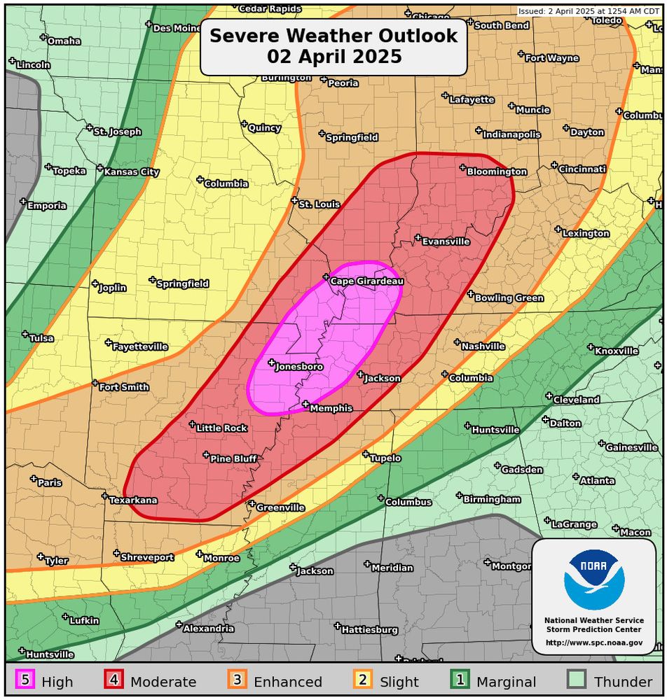
Severe Weather And Tornado Safety Links. In consideration of today’s High Risk severe weather and tornado outlook, including the potential for a tornado outbreak, here’s a refresher on severe weather and tornado safety: tornadoquest.org/2025/03/13/s... #tornado #wxsky
02.04.2025 12:35 — 👍 1 🔁 2 💬 0 📌 0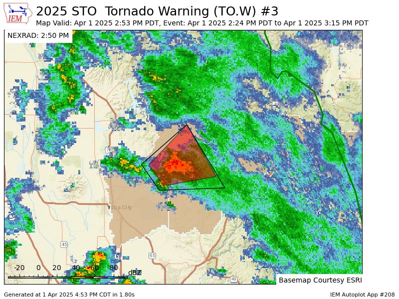
IEMBot Image TBD
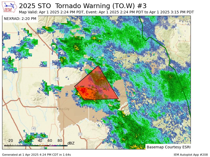
STO continues Tornado Warning [tornado: RADAR INDICATED, hail: 1.00 IN] for Nevada, Yuba [CA] till 3:15 PM PDT Link
01.04.2025 21:53 — 👍 1 🔁 1 💬 0 📌 0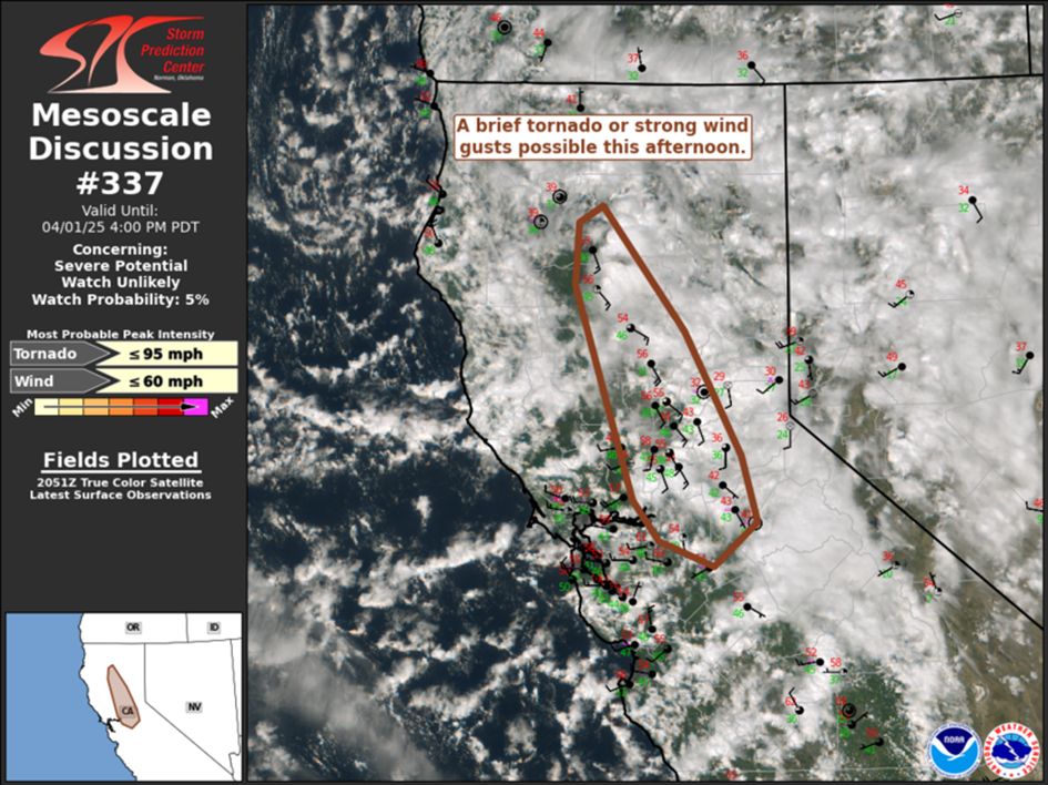
Portions of Sacramento/San Joaquin Valleys
A couple stronger thunderstorms may exhibit low-level rotation. A brief tornado or strong wind gust is possible. Watch issuance unlikely. #cawx
www.spc.noaa.gov/products/md/...
IEMBot Image TBD
STO issues Tornado Warning [tornado: RADAR INDICATED, hail: 1.00 IN] for Nevada, Yuba [CA] till 3:15 PM PDT Link
01.04.2025 21:24 — 👍 1 🔁 1 💬 0 📌 0#CAwx #California #Weather #Redding #chico #sacramento #Stockton #trailerparks
01.04.2025 13:36 — 👍 0 🔁 0 💬 0 📌 0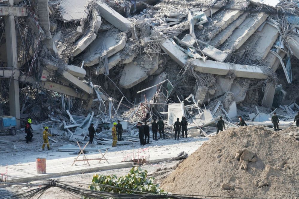
#Earthquake
🔴 In Bangkok, a high-rise building under construction collapsed near the city’s Chatuchak Market
FOLLOW LIVE ⬇️
🚨 BREAKING 🚨
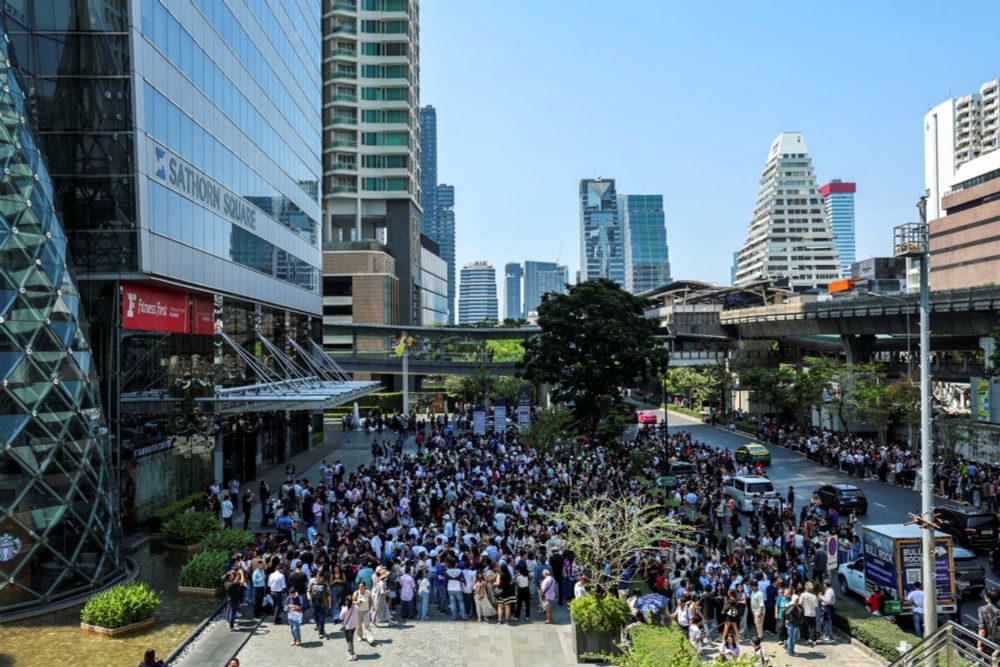
Powerful 7.7-magnitude quake strikes Myanmar with tremors felt in Bangkok
FOLLOW LIVE UPDATES ⬇️

<snort>
26.03.2025 23:09 — 👍 348 🔁 67 💬 8 📌 2