Ext ens have been consistently hinting at this for the past 2+ weeks. Cautiously optimistic.
30.01.2026 16:11 — 👍 0 🔁 0 💬 0 📌 0

Fantastic waterspout in front of Cetraro, Calabria. Photo by Albertina Pepe
28.01.2026 15:03 — 👍 33 🔁 11 💬 0 📌 1
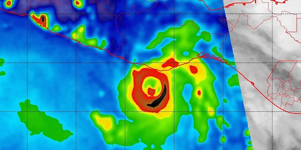
It was even visible on satellite this morning!
25.01.2026 04:22 — 👍 1 🔁 0 💬 0 📌 0

Gotta love DIA snow/precip measurements...
✅ Boulder 1.4" of snow, 0.07" of liquid = 20:1 snow ratio
🤷♀️ Denver 1.7" of snow, 0.02" of liquid = 85:1 snow ratio
#COwx #Boulderwx
24.01.2026 17:59 — 👍 8 🔁 1 💬 0 📌 0
7th day at 60°+ this month, 25 of the last 36 days have been at 60°+ in Denver. This winter is stupid.
#COwx
13.01.2026 21:48 — 👍 73 🔁 15 💬 5 📌 3
Same with much of the southwestern US! Wow
02.01.2026 19:38 — 👍 1 🔁 0 💬 1 📌 0
To be fair, models have been locked on that Jan 8-11 storm for multiple days already.
02.01.2026 18:22 — 👍 0 🔁 0 💬 1 📌 0

Lenticular-ish KH wave spotted 12/24 near Nederland, CO
26.12.2025 18:07 — 👍 2 🔁 0 💬 0 📌 0

Snapshot of PDS Red Flag Warning from National Weather Service in Boulder, CO. The text begins: URGENT - FIRE WEATHER MESSAGE
National Weather Service Denver/Boulder CO
508 PM MST Thu Dec 18 2025
...THIS IS A PARTICULARLY DANGEROUS SITUATION FOR IN AND IMMEDIATELY
ADJACENT TO THE FOOTHILLS, BETWEEN 5500 AND 9000 FEET, FOR BOULDER
AND JEFFERSON COUNTIES ON FRIDAY...
Strong west winds, sustained 45-55 mph with gusts upwards of 85-105
mph, are expected in the foothills of Boulder and Jefferson Counties
beginning early Friday morning. Relative humidity values are
expected to drop into the low teens, possibly upper single digits.
While Red Flag conditions, critical fire weather, are expected
across a larger area in northern Colorado, the most extreme
conditions are expected to be along Highway 93 from Jefferson County
into Boulder County and along US-36 north of Boulder to the Larimer
County line and westward. There will be a high potential for fast
moving wildfires...
NWS in Boulder, CO has just issued a rare "Particularly Dangerous Situation" (PDS) Red Flag Warning for extreme fire weather risk on Friday. Historically, PDS RFW issuances (including in California) have pinpointed days on which the most dangerous wildfires have occurred. #COwx
19.12.2025 00:23 — 👍 168 🔁 86 💬 7 📌 4
Officially our 6th-straight day at 60°+ in Denver.
We’ll tie our longest 60°+ December streak tomorrow, and break it on Tuesday.
#COwx
14.12.2025 19:47 — 👍 25 🔁 3 💬 3 📌 0
Never, ever gets old
14.12.2025 02:51 — 👍 1 🔁 0 💬 0 📌 0
What are some good sources of discussion on current oscillations/teleconnections and their forecast progression? Particularly for western US weather. CPC prognostic discussions sometimes cover these. The ENSO blog is no longer active. Any others?
10.12.2025 16:17 — 👍 0 🔁 0 💬 0 📌 0
Can you find the climatological anomaly on this map 😂
10.11.2025 03:08 — 👍 2 🔁 0 💬 0 📌 0
Has Cheyenne been issuing WWA for small, sub-county zones like this for a while? I was impressed when the Chicago office split up Cook County into three zones 😂
06.10.2025 03:32 — 👍 1 🔁 0 💬 1 📌 0

Albuquerque had consistent and overall above average dew points almost all monsoon season. Despite that, we ended up 1.41" below average with 3.07" of rain this year. The 32nd driest monsoon on record of 134 years. It was also the 5th warmest.
01.10.2025 14:45 — 👍 20 🔁 6 💬 2 📌 0

☔️ It's Denver's wettest day in over 2 years! ☔️
1.21" of rain at Central Park = wettest day there since July 5, 2023 (811 days).
#COwx
24.09.2025 01:41 — 👍 59 🔁 7 💬 2 📌 0
Tornado near Pleaant View, Colorado this afternoon…near the Utah/Colorado line in southwestern Colorado!
📸: Landan Wilson
13.09.2025 20:34 — 👍 106 🔁 27 💬 4 📌 4


Fresh snow just above Telluride this morning!
Looks like it got down to about 11k feet!
#COwx
13.09.2025 14:31 — 👍 54 🔁 2 💬 1 📌 2
It was just an ordinary late-summer evening in #Boulder, until it wasn't...
How it started: ⛰️⛅️😎
How it ended: 🌫️😶🌫️😷
#COWX #Smoke #ThanksCanada
05.09.2025 03:48 — 👍 15 🔁 3 💬 0 📌 1
Wouldn’t mind a few more big thunderstorms, then I’ll be ready for winter!
01.09.2025 22:44 — 👍 1 🔁 0 💬 1 📌 0
My favorite type of abnormal
30.08.2025 23:16 — 👍 1 🔁 0 💬 1 📌 0
Amazing compositions
28.08.2025 01:35 — 👍 2 🔁 0 💬 1 📌 0
Champaign is 10” below the average for this time of year??
26.08.2025 01:32 — 👍 1 🔁 0 💬 1 📌 0

Possible gustnado viewed from 2 miles W Arriba, CO looking due N 4:39 pm #cowx
10.08.2025 22:40 — 👍 2 🔁 0 💬 0 📌 0

Storm getting its act together 1 mile N Limon, CO 3:55 pm #cowx
10.08.2025 21:58 — 👍 2 🔁 0 💬 0 📌 0
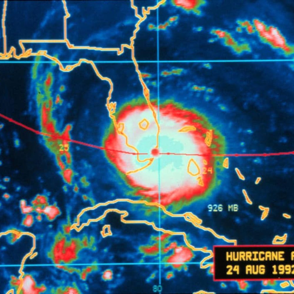
Critical Hurricane Forecast Tool Abruptly Terminated
U.S. Department of Defense announced Tuesday it would no longer process and deliver data essential to most hurricane forecasts
A huge blow was dealt to hurricane forecasters this week as a critical tool was abruptly terminated by the Department of Defense and NOAA. The immediate discontinuation of data from three weather satellites will severely impact hurricane forecasts this season and beyond. More ⬇️
26.06.2025 13:17 — 👍 2337 🔁 1567 💬 197 📌 447
Research Meteorologist/Developer. OU alum (PhD/MS). I study precipitation, microphysics, polarimetric radar, and tropical cyclones. Opinions = my own.
Your daily dose of historical weather and climate events.
NWS Meteorologist ~ Scott Doering
#weather #history #climate
https://sercc.com/weather-history/
Weather and climate scientist focused on extreme events like floods, droughts, & wildfires on a warming planet. www.weatherwest.com
Publisher and Editor, America 2.0. Baltimore/Washington. Pilot, chef, coder. america2.news Signal: davetroy.69
Staff writer, The Atlantic.
Politics, religion, culture, and other low stakes subjects.
Newsletter: theatlantic.com/newsletters/sign-up/deep-shtetl/
Music: bit.ly/azyashir
KRQE Chief Meteorologist | Nuevo México | OU Meteorology Grad | ⛈🌪🌴🌵🌄🌶 | Opinions are my own
We are an independent, nonprofit successor to Climate(.)gov, safeguarding public access to trusted climate data, tools, and information.
Donate: https://donorbox.org/climate-us-protected-by-you
Climate specialist with ACCAP/IARC at UAF, highlighting Alaska and Arctic climate, environment & Indigenous cultures. Opinions are my own.
Alaska and Arctic Climate Newsletter: https://alaskaclimate.substack.com/
Professional landscape photographer focused on Chicago and Ireland. My website is BarryButlerPhotography.com for prints, books and calendars.
Trees, plants, frisbee, mountains, oh my. (she/her).
Atmospheric Data Scientist @ tomorrow.io | Atmos AI Engineer 🤖 | μ-wave Nephologist ☁️ | Atmos PhD UofIllinois | #BillsMafia #Illini | he/him | Opinions my own |
Studying severe storm dynamics and prediction
Ph.D. Candidate @ OU | M.S. Texas Tech | B.S. Northern Illinois
The official BlueSky account of BoulderCAST, a team of local meteorologists that forecast Boulder and Denver weather as well as nearby mountain conditions.
Climate monitoring, climate research, and climate services for Colorado.
Based at the Department of Atmospheric Science, Colorado State University. https://climate.colostate.edu
"an upbeat atmospheric science professor" -- theverge | sometimes it snows in April | Fort Collins, Colorado | personal account
Senior meteorologist. MyRadar. Washington Post/NPR/TV too. Atmospheric scientist. Educational consultant. Harvard/MIT ‘19.
9NEWS Senior Meteorologist | AMS CHALA Broadcast Lead 🇨🇱 | NWA Seal of Approval | ⚽ PxP
25 Y/o Photographer and Storm Chaser based in Fort Collins, Colorado.
#wxsky #weather #photography #wxbluesky
Iowa Environmental Mesonet https://mesonet.agron.iastate.edu ,
Father of all the IEMBots here,
https://github.com/akrherz
Signal >> Noise, hopefully.
Meteorologist and research associate @ OU CAPS | M.S. OU '20 | B.S. UBC '18. Severe wx/music nut and contributor for US Tornadoes and Tornado Archive. Opinions my own.