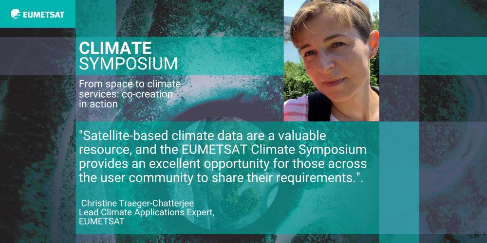
A photo of Christine Traeger-Chatterjee and along with her quote: "Satellite-based climate data are a valuable resource, and the EUMETSAT Climate Symposium provides an excellent opportunity for those across the user community to share their requirements. As a satellite data provider, this helps us provide bespoke support to climate services across Europe"
Have you registered to join us & celebrate 25 years of Climate@EUMETSAT?
28–30 October 2025
Darmstadtium in Darmstadt, Germany.
Visit: www.eventsforce.net/eumetsat/fro...
Discover what Christine Traeger-Chatterjee, Lead Climate Applications Expert at @eumetsat.int, says about the event...
👉 🧵[1/3]
26.06.2025 12:28 — 👍 6 🔁 1 💬 1 📌 1
A PNG image that gives details of the released products:
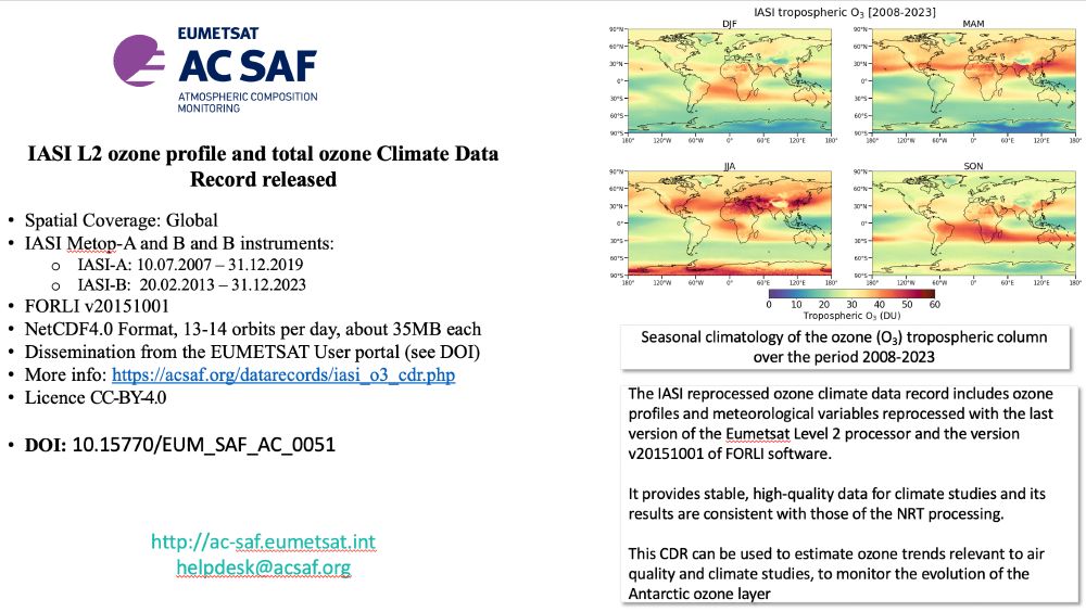
Title: IASI L2 ozone profile and total ozone Climate Data Record released
Spatial Coverage: Global
IASI Metop-A and B and B instruments:
IASI-A: 10.07.2007 – 31.12.2019
IASI-B: 20.02.2013 – 31.12.2023
FORLI v20151001
NetCDF4.0 Format, 13-14 orbits per day, about 35MB each
Dissemination from the EUMETSAT User portal (see DOI)
More info: https://acsaf.org/datarecords/iasi_o3_cdr.php
Licence CC-BY-4.0
DOI: 10.15770/EUM_SAF_AC_0051
WWW address and e-mail address:
http://ac-saf.eumetsat.int
helpdesk@acsaf.org
Short description:
The IASI reprocessed ozone climate data record includes ozone profiles and meteorological variables reprocessed with the last version of the Eumetsat Level 2 processor and the version v20151001 of FORLI software.
It provides stable, high-quality data for climate studies and its results are consistent with those of the NRT processing.
This CDR can be used to estimate ozone trends relevant to air quality and climate studies, to monitor the evolution of the Antarctic ozone layer
The #IASI reprocessed #ozone data record is released. Contains both total ozone and ozone profiles data. The EUMETSAT IASI L2 T and H2O are part of the data.
Stable, high-quality data for climate studies, consistent with the NRT processing.
DOI: 10.15770/EUM_SAF_AC_0051
acsaf.org/datarecords/...
16.06.2025 06:56 — 👍 4 🔁 1 💬 0 📌 0
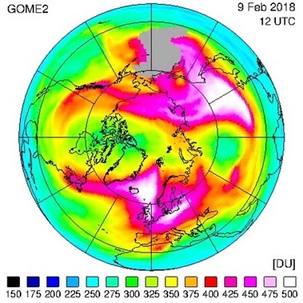
#Wildfires in #Canada have emitted massive amount #smoke that is clearly visible in GOME-2 (B+C) #AAI observations. Long range transportation over northern #Atlantic. AAI data either from #EUMETCast or SAF archive acsaf.org/products/arp...
02.06.2025 15:13 — 👍 26 🔁 6 💬 1 📌 0
The agenda is now online for Climate@EUMETSAT!
28–30 October 2025
Darmstadtium in Darmstadt, Germany.
Sessions will cover topics including climate policy, the future design of satellite climate products, & data access & utilisation.
Details & registration at: www.eventsforce.net/eumetsat/fro...
30.05.2025 11:08 — 👍 8 🔁 6 💬 2 📌 1

Tomorrow! Don't forget to sign up for our latest European Weather Cloud session with experts from @eumetsat.int and @ecmwf.int! Join us from 08:00 UTC online - more details and registration here: bit.ly/42LaZUu
13.05.2025 08:00 — 👍 4 🔁 2 💬 0 📌 0
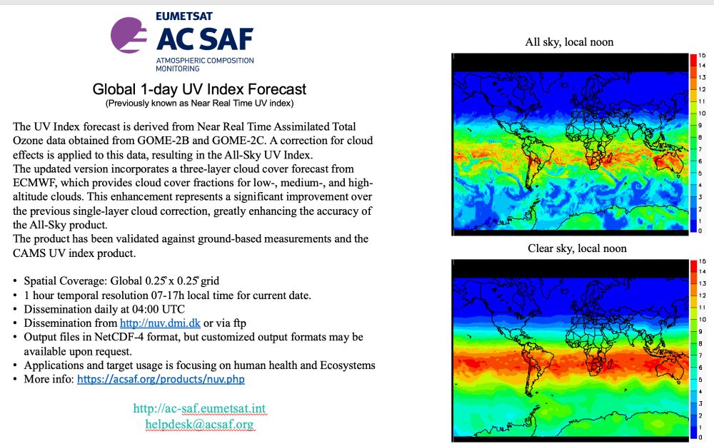
The Global 1-day UV Index Forecast is released today. This version have a three-layer cloud cover forecast from ECMWF, which provides cloud cover fractions for low-, medium-, and high-altitude clouds. Clear improvement over the previous single-layer cloud correction. acsaf.org/products/nuv...
13.05.2025 12:59 — 👍 4 🔁 2 💬 1 📌 0
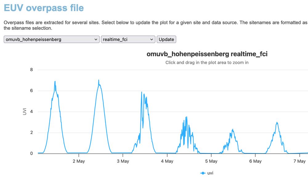
Did you know that cloud corrected European #UVI and #Erythemal daily dose from EUMETSAT's MSG #SEVIRI (2004-2024) and MTG #FCI (2025->) data are available. 15 min time resolution. Data, maps and #overpasses available. Images and overpasses acsaf.org/euv_validation/index.php
13.05.2025 08:14 — 👍 2 🔁 1 💬 0 📌 0
Did you know that cloud corrected European #UVI and #Erythemal daily dose from EUMETSAT's MSG #SEVIRI (2004-2024) and MTG #FCI (2025->) data are available. 15 min time resolution. Data, maps and #overpasses available. Data: acsaf.org/products/euv... , images and overpasses acsaf.org/euv_validati...
13.05.2025 08:06 — 👍 2 🔁 1 💬 0 📌 0
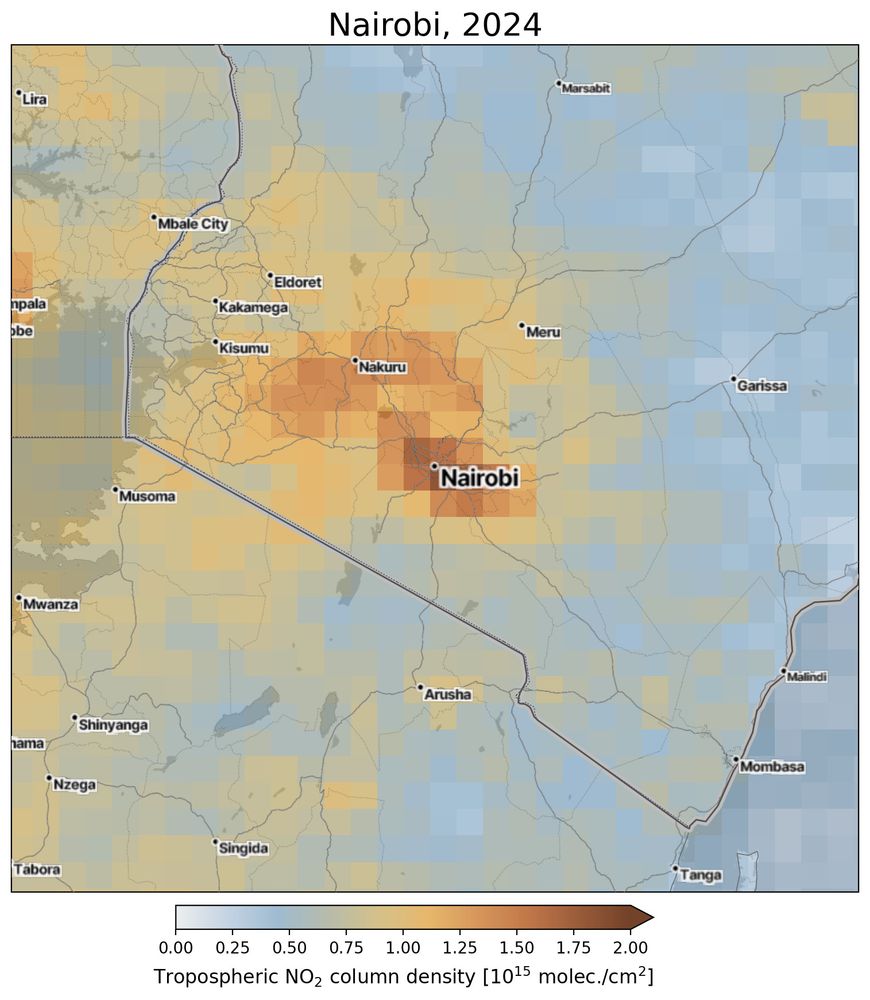
Nairobi and it's surrounding area. The high NO2 values are over the city itself and the other heavily populated areas near Nairobi. The NO2 values over countryside are much smaller due to lacking traffic.
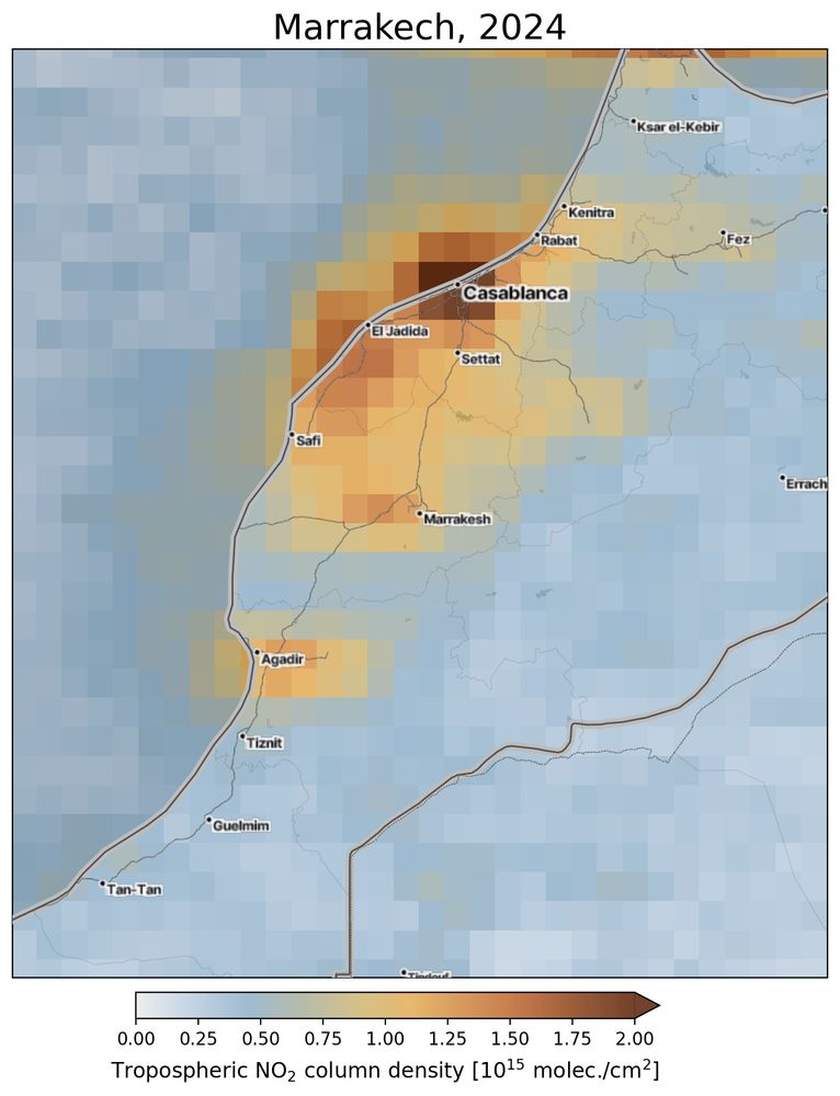
Casablanca, Marocco, and it's surrounding area. The high NO2 values are over the city itself and the other main cities along the coast like Rabat, Agadir and inland cities like Marrakesh. The NO2 values over countryside and Atlantic sea are much smaller.
Here are examples of GOME-2 B&C Level 3 Tropospheric NO2 for two African cities, Nairobi and Casablanca, annual mean 2024. NO2 is produced mainly in combustion of fossil fuels (coal, gas and oil) and especially fuel used in cars. Click images to get larger view.
29.04.2025 10:06 — 👍 3 🔁 1 💬 0 📌 0
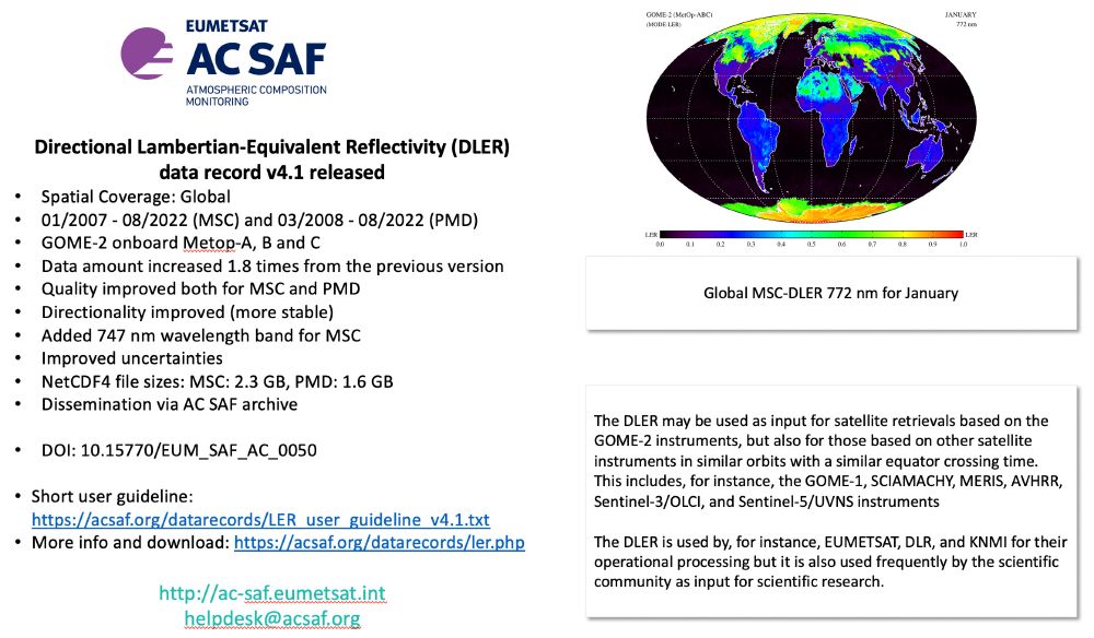
Announcement of the release of the Lambertian-Equivalent Reflectivity (DLER) v4.1 product.
Spatial Coverage: Global
01/2007 - 08/2022 (MSC) and 03/2008 - 08/2022 (PMD)
GOME-2 onboard Metop-A, B and C
Data amount increased 1.8 times from the previous version
Quality improved both for MSC and PMD
Directionality improved (more stable)
Added 747 nm wavelength band for MSC
Improved uncertainties
NetCDF4 file sizes: MSC: 2.3 GB, PMD: 1.6 GB
Dissemination via AC SAF archive
DOI: 10.15770/EUM_SAF_AC_0050
Image of global MSC-DLER 772 nm.
Directional #Lambertian-Equivalent #Reflectivity (DLER) version 4.1 is finally released. It has been available as demonstrational product a while, but now we can announce the official release. Added wl, improved errors, directionality and quality. Download and have a try! acsaf.org/datarecords/...
14.03.2025 13:48 — 👍 2 🔁 2 💬 0 📌 0
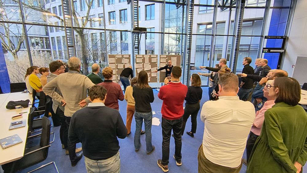
People standibng in front of screens in Open Space excercise and having ideas for the next sessions
@eumetsat.bsky.social
SAF Network meeting to plan the next phase for 2027-2032. New products, new services.
19.02.2025 13:53 — 👍 6 🔁 3 💬 0 📌 0
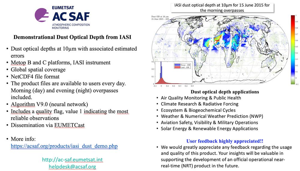
Short text with an image telling that the Demonstrational Dust Optical Depth from IASI is available:
Dust optical depths at 10µm with associated estimated errors
Metop B and C platforms, IASI instrument
Global spatial coverage
NetCDF4 file format
The product files are available to users every day. Morning (day) and evening (night) overpasses included.
Algorithm V9.0 (neural network)
Includes a quality flag, value 1 indicating the most reliable observations
Dissemination via EUMETCast
Contact: helpdesk@acsaf.org
Demonstrational IASI dust optical depth available via EUMETCast. More info and instructions: acsaf.org/products/ias...
05.02.2025 07:23 — 👍 8 🔁 4 💬 0 📌 0
We provide satellite-based Climate Data Records to support climate monitoring and adaptation. https://cm-saf.eumetsat.int
Tuotamme tietoa tulevaisuuden turvaksi – olosuhteet eivät saa yllättää ketään.
www.ilmatieteenlaitos.fi
IAGOS is a European Research Infrastructure for monitoring global atmospheric composition using commercial aircraft.
The #CopernicusClimate Change Service (#C3S) & #CopernicusAtmosphere Monitoring Service (CAMS), implemented by @ecmwf.int on behalf of the European Commission.
Professor of Atmospheric and Climate Science at the University of Washington. I study the natural and perturbed chemistry and composition of the atmosphere and how it interacts with weather and climate. But, I like other things too. Opinions my own, etc.
Principal Climate Change Scientist working on climate change & health including spatial modelling, urban environment, air quality, heat and cold, and co-benefits of climate action inc nature based solutions. Former geologist. PhD in Atmospheric Chemistry.
ECMWF senior scientist working on monitoring global #wildfire emissions, #airquality, atmospheric chemistry & #scicomm for the #CopernicusAtmosphere Monitoring Service @copernicusecmwf.bsky.social @ecmwf.int
Physicist; Senior Scientist @ CNRS; Invited professor @ ULB
Satellite remote sensing expert
Research Scientist at @ KMI - IRM - RMI.
Atmospheric Composition, Measurements and Modelling group (ACM²)
Weather and Climate; Stratosphere, UV, AQ, methane; hydrogen; EU CAMS, ESA remote sensing etc ; employed at knmi.nl ; If we would change, climate wouldn’t need to; @MichielvanWeele.bsky.social
Senior scientist at Finnish Meteorological Institute 🛰 #EarthObservation, #Satellites, #AirQuality, #Climate 🌍 Former forecasting meteorologist🌤
EUMETSAT's Ocean and Sea Ice Satellite Application Facility. 🛰
We are the dedicated @eumetsat.bsky.social centre for processing satellite data at the ocean-atmosphere interface.
European operational #satellite agency for monitoring weather, #climate and the environment from #space 🛰
eumetsat.int
official Bluesky account (check username👆)
Bugs, feature requests, feedback: support@bsky.app