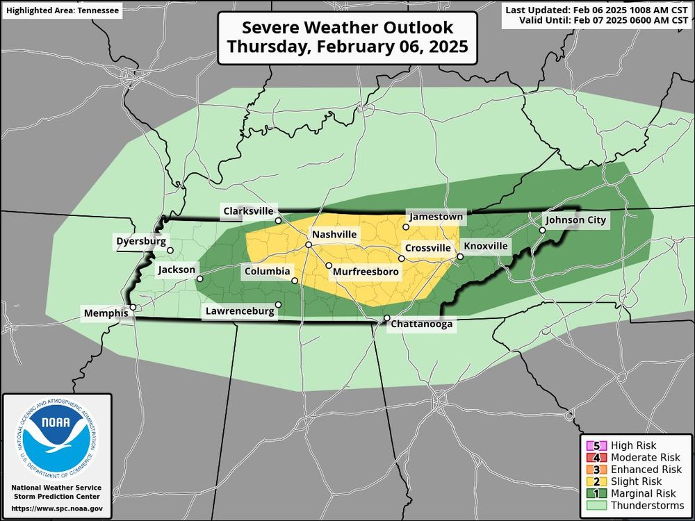
Going to be a fun day across Tennessee but luckily no Moderate Risk by the SPC.
2 rounds expected, one after lunch and one around dinner.

@deevoe.bsky.social
I like all forms of weather:🌪️🌀⚡️⛈️❄️ (I also may talk about wildlife, history, warships, and sports) Locations: Nashville and South Florida
Going to be a fun day across Tennessee but luckily no Moderate Risk by the SPC.
2 rounds expected, one after lunch and one around dinner.
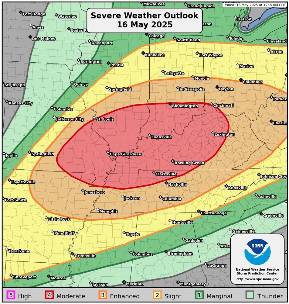
And we have a Moderate but just to the north of Nashville. Based on history, Kentucky should be very weather aware today.
#wxsky

The break is over, severe weather is likely returning tomorrow and Nashville is well inside the range for some of the worst weather tomorrow.
Still not Moderate, which is a good sign.
#wxsky

The drought will take a big hit this weekend for South Florida as much needed rain arrives during F1 week in Miami.
#wxsky

Nashville lucked out with the Tornadoes this morning but flooding is a serious issue. Now the NWS is coming back with more heavy rainfall this Saturday into Sunday. Creeks and Rivers are already high and not sure how much more they can handle by Sunday.
#wxsky

The worst of today’s severe weather should stay west of Nashville but we’re well within the possibility of some bad stuff. This event should be well after dark and possibly after midnight.
#wxsky

Winter isn’t done with Nashville quite yet.
#wxsky

Nashville is well inside the strike zone for Sunday night’s storms. An after dark event is likely again.
30.03.2025 05:51 — 👍 0 🔁 0 💬 0 📌 0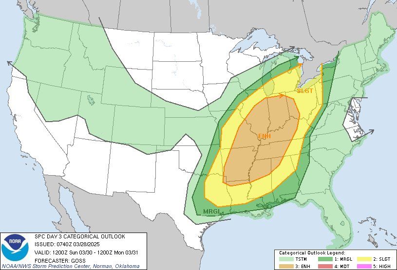
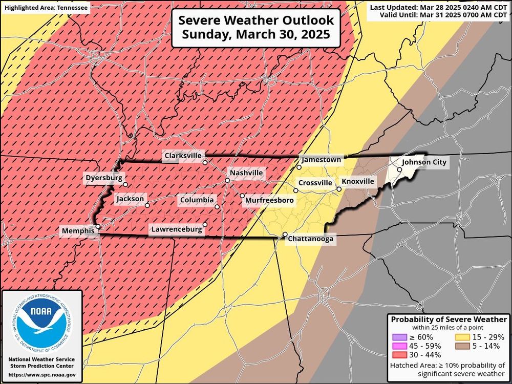

Sunday is going to be a wild day for storms as just about everything is on the table. Timing for Nashville will be after dark but before midnight, 10-11pm. Hopefully the storms start weakening before Middle Tennessee.
#wxsky

Friday’s Severe Weather Outlook includes the Nashville area but hopefully storms will be dying down as they approach at night. Another round is setting up for Saturday but the risk is mainly for East Tennessee.
#wxsky
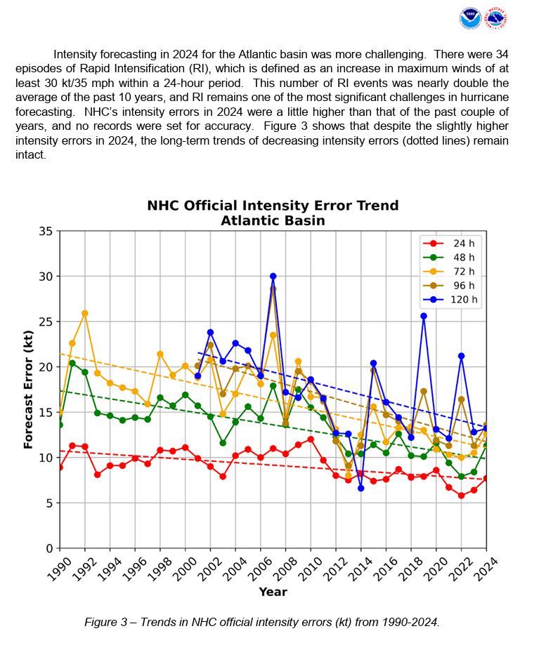

NHC Atlantic issued their 2024 report and the news is good, models continue to get better and better.
Also Potential Tropical Cyclones will be designated 72 hours before formation instead of 48 hours, which will help with quick strike events like Hurricane Helene.
#wxsky

Snow should start falling in Nashville around midnight, maybe a little earlier. Chances for school on Wednesday down to 1%.
#wxsky

Impacts should start Tuesday evening and be worse on Wednesday. Nashville should expect a below freezing temperatures until Sunday, so expect untreated roads to stay crappy for most of the week.
#wxsky
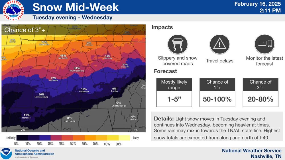
Snow incoming for Nashville starting Tuesday Night then a dramatic freeze for the rest of the week.
Don’t expect schools to be open much, maybe Friday.
#wxsky
Severe threat for Nashville and Tennessee is growing for Saturday Night, timing could be well after dark.
#wxsky

Some rough storms are possible starting tomorrow across Tennessee and the rest of the Deep South.
#wxsky

Nashville has a chance of snowfall next week, but either way it’ll be cold.
#wxsky
Chance of severe weather and tornados today in the Nashville area. Primetime is afternoon.
#wxsky

Nashville could see some severe weather and possibly tornados tomorrow night as the spring storm season starts to kick off a little early this year.
#wxsky

It’s a long way out, but there’s a chance that very cold air returns in the 2nd half of February. Until then, warm and muggy for the South.
#wxsky


Now that the deep freeze is ending, warm air from the Gulf of Mexico will rise up into the South on Thursday and with it some severe storms and possible tornados. Nashville is outside the strike zone but it’s not 0%.
#wxsky
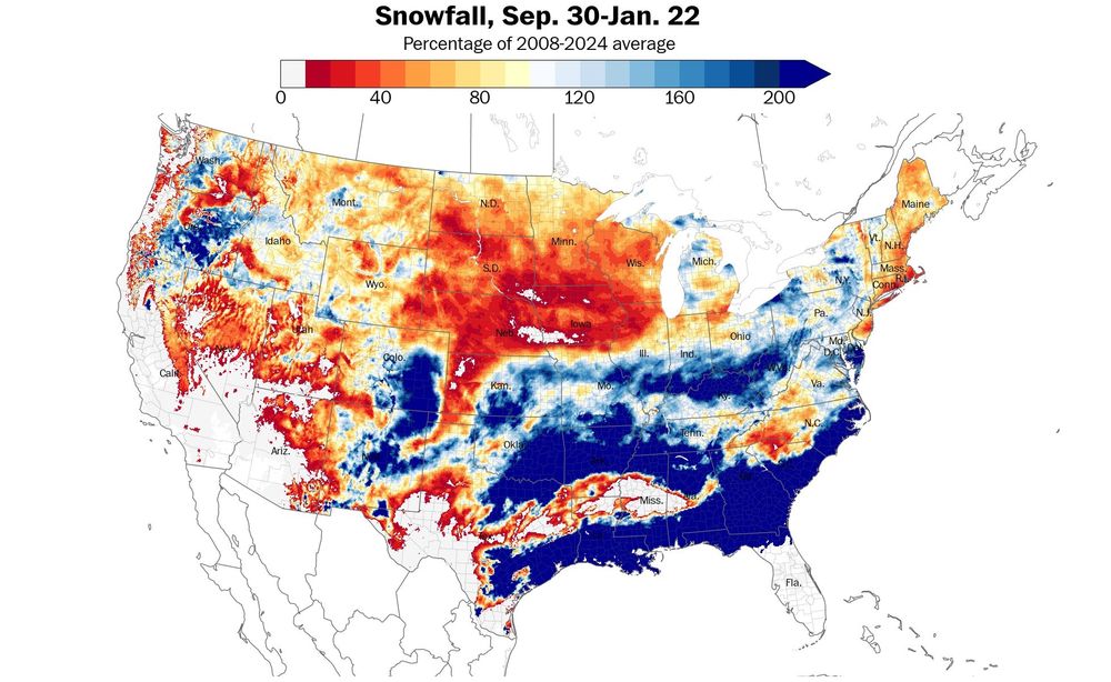
The Southeast is dominating the rest of the U.S. for snowfall.
#wxsky

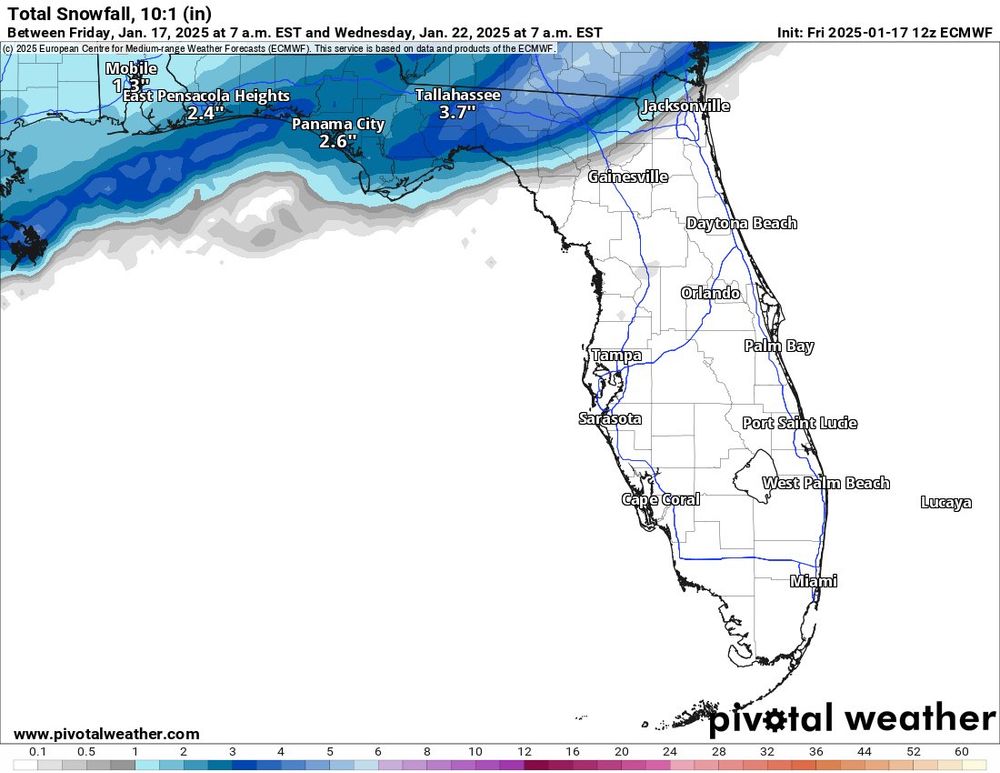


Chances of a very strange event happening in Florida are increasing as we’re now inside 5 days. Snow and ice possible in North Florida, but any shift north could make for another major event in Atlanta and Birmingham.
17.01.2025 21:53 — 👍 0 🔁 0 💬 0 📌 0
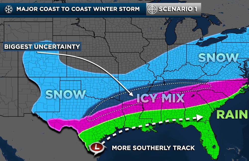
Very cold air will be rolling through the South next week, especially Nashville. Chances of snow vary greatly by model though.
#wxsky


About 24 hours out and the NWS is settling in on a more northern snow event through Tennessee while states Alabama and Georgia will get mostly Ice.
#wxsky

Nashville looking to get something significant out of this storm, should start Friday morning to midday and continue through Sunday early morning.
#wxsky

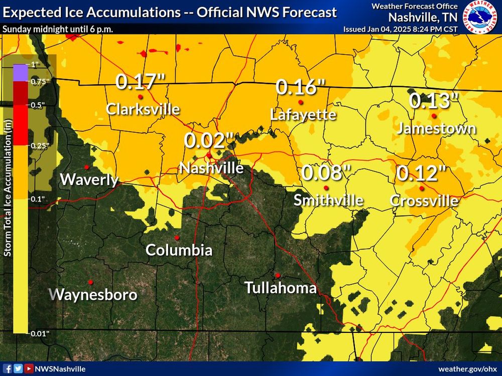
Nashville is now included in the Winter Weather Advisory, might be some minimal icing tomorrow.
#wxsky

While the snow and ice potential is pulling North, the severe storm threat is increasing in the South. Nashville has a shot to miss both events and just get rain with limited impacts.
#wxsky


Huge update for Nashville in todays models, real chance of Snow and Ice next weekend.
#wxsky

This is a much better signal for Tennessee as the risk area is shifting South away from Nashville.
#wxsky