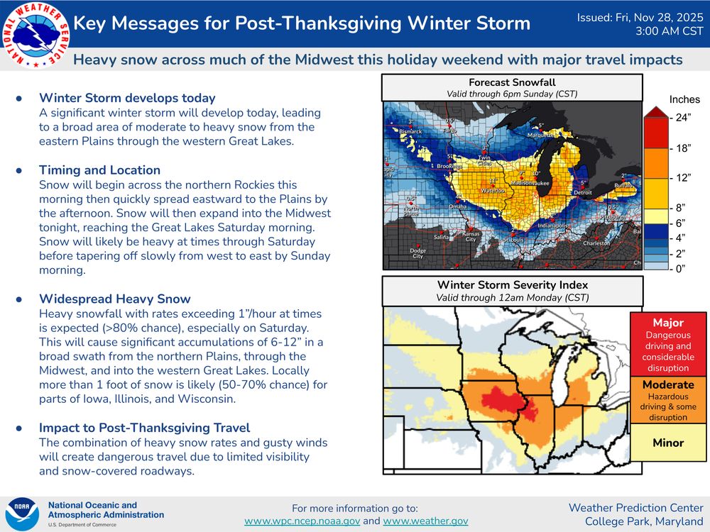
Two winter storms will cause dangerous travel conditions across the northern tier of the country into the weekend. Here are the latest Key Messages for these storms.
28.11.2025 15:38 — 👍 89 🔁 26 💬 0 📌 4
@wxmvpete.bsky.social
Meteorologist at NOAA's Weather Predicition Center. Proud father & husband. Northern VA raised, DC sports fan. My thoughts & opinions are my own.
Two winter storms will cause dangerous travel conditions across the northern tier of the country into the weekend. Here are the latest Key Messages for these storms.
28.11.2025 15:38 — 👍 89 🔁 26 💬 0 📌 4
Following the ongoing winter storm across the Upper Midwest, another storm system is forecast to impact parts of the Midwest and Great Lakes with wintry weather this weekend. Keep an eye on the forecast and check weather.gov for more information. ❄️
25.11.2025 23:55 — 👍 108 🔁 29 💬 5 📌 13
My shot of tonight's aurora from Manchester, MD.
12.11.2025 01:37 — 👍 53 🔁 5 💬 1 📌 0
Happy Halloween to all the witches, ghosts, ghouls, and K-Pop Demon Hunters slaying demons on their way to getting candy tonight!
31.10.2025 18:57 — 👍 3 🔁 0 💬 0 📌 0This meso loop of #Melissa from CIRA is absolutely stunning at it makes its closes in on landfall in southwestern Jamaica.
rammb-data.cira.colostate.edu/tc_realtime/...
#hurricanemelissa
896mb. Outrageous. #Melissa
28.10.2025 13:04 — 👍 12 🔁 1 💬 1 📌 0Watching this game: "3 turnovers inside KC territory is maddening and it is same old, same old"
What the score says: "7-7 at halftime in KC? Have to take that."
It is WV and it is WV3: weather.ndc.nasa.gov/goes/abi/goe...
26.10.2025 21:12 — 👍 2 🔁 0 💬 0 📌 0


Seeing the eye steadily warm/dry out from where it was 4 hours ago (1430Z) to where it is now (1830Z) is another clear sign of #Melissa strengthening. Each HH pass through the eye is showing a warming/drier mid-level layer. And a lower pressure reading each time, of course.
26.10.2025 18:44 — 👍 30 🔁 9 💬 2 📌 0While the track is coming into much better agreement, there remains a good deal of spread regarding when #Melissa makes its NE turn. @burgwx.bsky.social's page shows some members are lagging SW of Jamaica while some are more progressive.
26.10.2025 15:21 — 👍 5 🔁 2 💬 0 📌 0To add to the bad news, as the storm drifts west, easterly to SErly flow will blast Jamaica with bands of heavy rainfall well in advance of landfall. Idk what Jamaica's wettest 3 or 4-day observed rainfall is in its recorded history, but have to think #Melissa has a good chance to break it.
26.10.2025 15:08 — 👍 15 🔁 3 💬 1 📌 006Z HAFS-B pressure forecast was closer to what HHs were observing earlier today. It shows another period of RI starting sometime tonight and into Monday morning. Given #Melissa has another 48 hrs over the Caribbean, it unfortunately still has time to strengthen prior to landfall.
26.10.2025 15:08 — 👍 9 🔁 2 💬 1 📌 1Congrats!!
26.10.2025 02:30 — 👍 1 🔁 0 💬 0 📌 0Comparison between this morning & evening NOAA tail Doppler radar data shows Hurricane Melissa rapidly intensifying. Will be a major hurricane soon and a generational storm for Jamaica.
26.10.2025 01:39 — 👍 39 🔁 25 💬 0 📌 2Tail Doppler Radar (TDR) data from the current recon mission into Melissa shows that the vortex is vertically stacked up to 15 km w/ the upshear/NW quad being the strongest.
This is about as favorable of a vortex structure as you’ll see for rapid intensification
Plots from @cyclonicwx.bsky.social

12z 25 Oct Google DeepMind Short-Term Ensemble Forecast through 42h.

12z 25 Oct ECMWF 36h Forecast with 850-200 mb steering (shaded), direction (streamlines), 925 mb relative vorticity (yellow shading), and sea level pressure (black contours). Illustrating the WSW deep layer steering associated with Melissa.

12z 25 Oct ECMWF Area Average Profile, illustrating the northerly flow at 500-300 mb, and overall 850-300 mb steering to be slowly WSW.

5pm 25 October Tropical Cyclone Discussion of Hurricane Melissa from the National Hurricane Center.
One thing I am watching closely tonight is the short-term motion of #Melissa.
Google DeepMind ensemble has been pretty consistent in showing a WSW motion beginning tonight, & this appears supported by the ECMWF deep-layer steering-flow as the hurricane becomes vertically deep. Diagnosed below ⤵️

Latest Vortex message for #Melissa now states the eyewall is closed. Full steam ahead on RI.
25.10.2025 23:18 — 👍 7 🔁 3 💬 0 📌 0
104 WTNT33 KNHC 252055TCPAT3 BULLETINHurricane Melissa Advisory Number 18NWS National Hurricane Center Miami FL AL132025500 PM EDT Sat Oct 25 2025 ...MELISSA LIKELY STARTING TO RAPIDLY INTENSIFY AND EXPECTED TOBECOME A MAJOR HURRICANE TOMORROW......LIFE-THREATENING AND CATASTROPHIC FLASH FLOODING AND LANDSLIDESEXPECTED IN PORTIONS OF SOUTHERN HISPANIOLA AND JAMAICA INTO EARLYNEXT WEEK... SUMMARY OF 500 PM EDT...2100 UTC...INFORMATION----------------------------------------------LOCATION...16.6N 75.5WABOUT 130 MI...210 KM SE OF KINGSTON JAMAICAABOUT 250 MI...405 KM WSW OF PORT AU PRINCE HAITIMAXIMUM SUSTAINED WINDS...90 MPH...150 KM/HPRESENT MOVEMENT...W OR 275 DEGREES AT 3 MPH...6 KM/HMINIMUM CENTRAL PRESSURE...974 MB...28.77 INCHES WATCHES AND WARNINGS--------------------CHANGES WITH THIS ADVISORY: The government of Cuba has issued a Hurricane Watch for the Cuban provinces of Granma, Santiago de Cuba, Guantanamo, and Holguin. SUMMARY OF WATCHES AND WARNINGS IN EFFECT: A Hurricane Warning is in effect for...* Jamaica A Hurricane Watch is in effect for...* Southwestern peninsula of Haiti from the border with theDominican Republic to Port-Au-Prince* Cuban provinces of Granma, Santiago de Cuba, Guantanamo, and Holguin. A Tropical Storm Warning in effect for...* Southwestern peninsula of Haiti from the border with theDominican Republic to Port-Au-Prince A Hurricane Warning means that hurricane conditions are expectedsomewhere within the warning area. A warning is typically issued36 hours before the anticipated first occurrence oftropical-storm-force winds, conditions that make outsidepreparations difficult or dangerous. Preparations to protect lifeand property should be rushed to completion. A Hurricane Watch means that hurricane conditions are possiblewithin the watch area. A Tropical Storm Warning means that tropical storm conditions areexpected somewhere within the warning area within 36 hours. Interests elsewhere in Haiti, the Dominican Republic, eastern Cuba,the southeastern and central Bahamas, and the Turks and CaicosIslands should monitor the progress of Melissa. Watches could berequired for portions of eastern Cuba later today. For storm information specific to your area, please monitorproducts issued by your national meteorological service. DISCUSSION AND OUTLOOK----------------------At 500 PM EDT (2100 UTC), the center of Hurricane Melissa was located near latitude 16.6 North, longitude 75.5 West. Melissa is moving toward slowly the west near 3 mph (6 km/h). A slow westward motion is expected tonight through the end of the weekend. A turn to the north and northeast is forecast on Monday and Tuesday. On the forecast track, the center of Melissa is expected to move near or over Jamaica during the weekend and early next week, and it could be near or over eastern Cuba by the middle of next week. Maximum sustained winds have increased to near 90 mph (150 km/h) with higher gusts. Rapid intensification is forecast to continue over the next day or so and Melissa is forecast to become a major hurricane tomorrow and is expected to still be a major hurricane when making landfall in Jamaica early next week. Hurricane-force winds extend outward up to 15 miles (30 km) from thecenter and tropical-storm-force winds extend outward up to 160 miles(260 km). The estimated minimum central pressure is 974 mb (28.77 inches). HAZARDS AFFECTING LAND----------------------Key messages for Melissa can be found in the Tropical CycloneDiscussion under AWIPS header MIATCDAT3 and WMO header WTNT43 KNHC. WIND: Tropical storm conditions are expected to begin in Jamaica bytonight, with hurricane conditions expected by Sunday or Monday.Tropical storm conditions are expected and hurricane conditions arepossible within the watch and warning area in Haiti later today. Hurricane conditions are possible in the watch area in eastern Cuba on Tuesday into Wednesday. RAINFALL: Melissa is expected to bring total rainfall of 15 to 30 inches to portions of southern Hispaniola and Jamaica into Wednesday, with local maxima of 40 inches possible. Additional heavy rainfall is likely beyond Wednesday, but exact storm totals are still uncertain. Catastrophic flash flooding and landslides are probable across portions of southern Hispaniola and Jamaica.For eastern Cuba, total rainfall of 6 to 12 inches, with local amounts to 18 inches, are expected into Wednesday resulting in life-threatening flash flooding and landslides. Additional heavy rainfall is likely beyond Wednesday, but exact storm totals are still uncertain. For a complete depiction of forecast rainfall associated withMelissa, please see the National Weather Service Storm TotalRainfall Graphic, available athurricanes.gov/graphics_at3.shtml?rainqpf STORM SURGE: Life-threatening storm surge is becoming more likelyalong the south coast of Jamaica later in the weekend or early nextweek. Peak storm surge heights could reach 9 to 13 feet aboveground level, near and to the east of where the center of Melissamakes landfall. This storm surge will be accompanied by large anddestructive waves. There is a potential for significant storm surge along thesoutheast coast of Cuba early next week. SURF: Swells generated by Melissa are expected to affect portionsof Hispaniola, Jamaica, and eastern Cuba during the next severaldays. Please consult products from your local weather office. NEXT ADVISORY-------------Next intermediate advisory at 800 PM EDT.Next complete advisory at 1100 PM EDT. $$Forecaster Papin

Hurricane Melissa 5-Day Uncertainty Track Image

Hurricane Melissa 34-Knot Wind Speed Probabilities
Atlantic Hurricane Melissa Advisory Number 18
...MELISSA LIKELY STARTING TO RAPIDLY INTENSIFY AND EXPECTED TO BECOME A MAJOR HURRICANE TOMORROW... ...LIFE-THREATENING AND CATASTROPHIC FLASH FLOODING AND LANDSLIDES EXPECTED IN PORTIONS OF SOUTHERN HISPANIOLA AND JAM...
Additional Details Here.
Quick shout out to @pppapin.bsky.social & his colleagues at NHC who have been outstanding in forecasting #Melissa & coordinating with our (WPC's) International Desk. Phillipe's latest 5PM EDT discussion is excellent.
24.10.2025 21:29 — 👍 19 🔁 1 💬 1 📌 0
There are two noteworthy things about the latest NHC forecast for Melissa:
1. This is the first time NHC explicitly forecast rapid intensification at day 3-4 lead time
2. If latest forecast trends hold, this forecast could still be a significant intensity underestimate

Overnight guidance has continued to abandon Melissa turning NE into Hispaniola, and is increasingly concentrated on a west track south of Jamaica - a scenario which could easily support a category 5 hurricane in an exceptionally favorable environment for intensification.
22.10.2025 11:59 — 👍 56 🔁 23 💬 1 📌 3Can't say enough about what Ohtani did tonight. We have seen games where a pitcher dominated or a hitter be the bulk of the offense in 1 game, but he did BOTH. If you look up the phrase "put the team in his back", this performance will be the quintessential definition of that
18.10.2025 02:58 — 👍 3 🔁 0 💬 0 📌 0Felt like Karen's only two outcomes coming into this year to me were this situation, or becoming a cat 5. There was no in betweem haha
10.10.2025 23:34 — 👍 2 🔁 0 💬 0 📌 0It has similarities to it, but given we most commonky assocoate them with systems that also produce winter weather, it has been mainly communicated as a coastal low.
10.10.2025 13:11 — 👍 0 🔁 0 💬 1 📌 0Not starting Dart week 1 appears to be malpractice in hindsight.
10.10.2025 02:09 — 👍 2 🔁 0 💬 0 📌 0
WPC has started Key Messages for the coastal storm that is set to bring a myriad of impacts to the East Coast this weekend. These will be updated under WPC's Top Stories section on WPC's homepage each day through the upcoming weekend.
08.10.2025 18:24 — 👍 16 🔁 7 💬 1 📌 0
Global Ensemble Forecast System mean precipitable water and 700-mb winds valid on Saturday morning, 11 October 2025. A big plume of moisture will be transported into the southwest US ahead of decaying Hurricane Priscilla. From https://schumacher.atmos.colostate.edu/weather/ens.php

Standardized anomaly of precipitable water from the ECWMF ensemble mean on Saturday morning, 11 October 2025. It shows a broad swath of greater than +3 standard deviations in the western US. From https://schumacher.atmos.colostate.edu/weather/ecmwf.php

Ensemble forecast plume showing precipitable water at Grand Junction, Colorado in the members of the ECWMF ensemble. Values are predicted to be around 25-30 mm with high confidence on Friday 10 October through Saturday 11 October, far above the 90th percentile for the date. From https://schumacher.atmos.colostate.edu/weather/ecmwf.php
Highly unusual situation approaching western Colorado with the moisture from Hurricane Priscilla. Grand Junction has never had precipitable water over an inch (25mm) so late in the year, but looks like it will be near that level on both Fri & Sat. Six standard deviations above average! #cowx 1/2
08.10.2025 14:23 — 👍 64 🔁 24 💬 4 📌 1
Heavy rain is coming to the Southwest over the next 7 days thanks to Priscilla late week & the trailing East Pacific disturbance this weekend. Flooding is going to be a problem the second half of the week in heavily impacted areas, along complex terrain, & over burn scars.
08.10.2025 11:49 — 👍 6 🔁 3 💬 0 📌 0
My initial reaction: "oh man, if only this were January!"
Thinks more about how recent years have gone: "it would find a way to be 33 and rain, wouldn't it."
*whispers* Drake Maye did a lot of Josh Allen shit tonight
06.10.2025 03:18 — 👍 1350 🔁 85 💬 47 📌 10