last 6 hours of radar and satellite. #CycloneMitchell
08.02.2026 04:37 — 👍 0 🔁 0 💬 0 📌 0
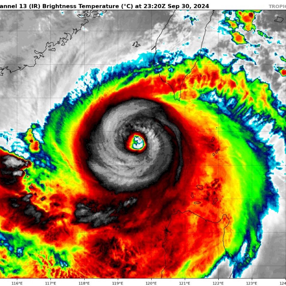
Eastward upper outflow For STC #Mitchell looks restricted on the IR satellite loop which is likely hampering development with increasing shear also evident.
I think it has peaked and is unlikely to further intensify.
08.02.2026 04:33 — 👍 0 🔁 0 💬 1 📌 0


Winds picking back up on Barrow island with the backside of Severe Tropical #CycloneMitchell
Radar indicates some recent Southerly movement which may put Onslow in the firing line of the Eastern eyewall.
08.02.2026 04:21 — 👍 0 🔁 1 💬 0 📌 0
The last hour or so of Severe Tropical Cyclone #Mitchell viah Himawari-9 at high temporal resolution (2.5min). This is from the red, 640nm band imager.
08.02.2026 01:34 — 👍 0 🔁 0 💬 0 📌 1

Microwave image in red and green showing eye of cyclone Mitchell nust NE of Barrow island

Microwave image in red and green showing eye of cyclone Mitchell nust NE of Barrow island
Most recent MW images (05:25 AWST) show strongest convection is likely to be on backside of #Cyclone #Mitchell
08.02.2026 01:21 — 👍 0 🔁 0 💬 0 📌 0

Obs beginning to peak at Barrow Island for Severe Tropical #CycloneMitchell Pressure down to 980 hPa.
08.02.2026 01:14 — 👍 0 🔁 1 💬 1 📌 0

Admittedly this is resonably old (5:40am AWST 7th Feb) but it is the latest MW image with decent coverage, and it looks more impressive than I thought with really strong convection in the NE quad #CycloneMitchell.
It has definitely improved since then so Im looking forward to another good sat pass.
07.02.2026 05:52 — 👍 1 🔁 0 💬 0 📌 0
Large eye feature on the radar loop from Tropical Cyclone Mitchell, with outer bands hitting Port Hedland right now. Keep an eye on Barrow Island AWS as the centre of the system approaches. #CycloneMitchell
07.02.2026 02:15 — 👍 2 🔁 0 💬 0 📌 0
Most recent RGB satellite loop. Track map has a likely crossing near Onslow, a town of about 800 people but also crossing Barrow Island, where the worlds highest non tornadic wind was ever recorded.
07.02.2026 01:50 — 👍 2 🔁 0 💬 0 📌 0


Tropical Cyclone Mitchell (#21U / 20S) is a pretty large system and is currently at 982hPa Cat 2 (Aus scale) with sustained winds around the 50 kt (92km/h) mark.
With warm seas, low-mod shear tons of moisture and good outflow, it is expected to strengthen today to cat 3 with winds to 80 kt.
07.02.2026 01:50 — 👍 1 🔁 0 💬 1 📌 0
Tropical Low 21U -> Tropical cyclone. Seems likely for the Pilbra / Gascoyne regions of WA with all major models on the same page. It could be a nasty one too with some models down to 960 hPa. #21U
05.02.2026 00:55 — 👍 0 🔁 0 💬 0 📌 0
That flow tho.
02.02.2026 02:17 — 👍 243 🔁 59 💬 5 📌 9
You may have seen pictures, but have you ever seen video of a gigantic jet #TLE from space?
Astronaut Jeanette Epps captured this incredible sequence on July 20th, 2024 for the DTU/@science.esa.int Thor-Davis experiment. 🧪🔭
youtu.be/xN2J7_rOBJY
Credit: ESA/NASA/J. Epps
Processing: Simeon Schmauß
30.01.2026 21:09 — 👍 535 🔁 221 💬 15 📌 18
Ex TC Luana is drenching central WA right now
27.01.2026 05:32 — 👍 2 🔁 0 💬 0 📌 0

Mildura is seeing some seriously dry air! 48 °C with DP of -1.5 °C! #VicWx #AusWx
27.01.2026 05:17 — 👍 0 🔁 0 💬 0 📌 0

Former TC #Luana is over the #Kimberley region of #WesternAustralia. Another weak low pressure system is over the Cape York Peninsula, while monitoring tropical development near #Vanuatu next week.
25.01.2026 08:07 — 👍 5 🔁 2 💬 0 📌 0
Looks likethe broad eye feature is about to cross the coast.
24.01.2026 04:18 — 👍 1 🔁 0 💬 0 📌 0
Tropical Cyclone Luana just before it crosses the coast near Cape Leveque North of Broome
#TropicalCyclone #CycloneLuana #16U #17S #WAWx
24.01.2026 03:38 — 👍 4 🔁 1 💬 1 📌 0

James #Webb Space Telescope #JWST
Imaging dust knots in a planetary nebula
TARG: #NGC7293 #Helix Nebula
2024-10-24
PI: Garcia Marin, Macarena
NIRCAM 444-470 444 356 212 187 115
yuval-harpaz.github.io/astro/jwst_l...
NASA/ESA/CSA/STScI/j. Roger
20.01.2026 19:25 — 👍 61 🔁 22 💬 4 📌 1
Is the JWST image vertically flipped in orrientation? The lighting doesnt look correct?
22.01.2026 00:37 — 👍 0 🔁 0 💬 0 📌 0

This mess over Bonaparte gulf could consolidate into a tropical cyclone in the next week.
17.01.2026 07:25 — 👍 3 🔁 2 💬 0 📌 0
Using ai models to find errors in base data sets … especially when the models have been trained in the same data sets is impressive!!
13.01.2026 04:28 — 👍 1 🔁 0 💬 0 📌 0
Crab #pulsar and its environment in Messier 1. #Hubble image (ACS F550M). I added more frames. Same timescale between 2012 and 2016.
11.01.2026 18:50 — 👍 78 🔁 15 💬 3 📌 2
This is what it would look like to fly over the Martian North Pole aboard @esa.int's Mars Express orbiter.
This sequence of 117 images was captured by the VMC camera on June 14th, 2019 over the course of 3 hours and is played a 1200x speed. #planetsci
Credit: ESA/Simeon Schmauß
flic.kr/p/2rQAPdw
06.01.2026 19:00 — 👍 209 🔁 54 💬 4 📌 2

Wider view
08.01.2026 00:35 — 👍 0 🔁 0 💬 0 📌 0
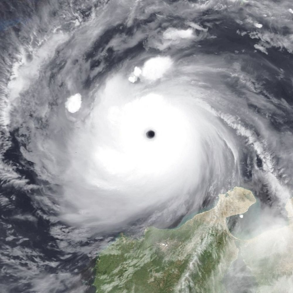
On 6th Jan Severe Tropical Cyclone Jenna peaked at category 3 (Aus scale) after skirting the Cocos Islands.
It made an impressive sight as it span away over the Indian ocean!
#WX #Cyclone #WAWx #CycloneJenna
08.01.2026 00:21 — 👍 2 🔁 1 💬 1 📌 0

The North Atlantic tonight going into the final day of 2025. #avgeography @flightradar24.com
31.12.2025 04:36 — 👍 78 🔁 8 💬 1 📌 1
According to BOM Tropical Cyclone Hayley has now peaked as a category 4 on the Aus scale with 10 minute sustained wind speeds of 165 km/h (100 mph). JTWC 1 min est. is the same. Shear has seemingly begun to increase and should induce weakening leading up to landfall tonight local time.
29.12.2025 20:55 — 👍 464 🔁 95 💬 17 📌 2


Recently named Cyclone #Hayley has unexpectedly intensified into a category 4. A cat 3 landfall is expected in the northern Kimberley.
The last season to see 3 severe TC's before the New Year was way back in 1998-99.
The last season to see 3 cat 4 TC's before the New Year was... never!
29.12.2025 22:40 — 👍 4 🔁 2 💬 1 📌 0
#AvGeek Photographer And Weather Enthusiast Living In Perth, Western Australia. https://www.redbubble.com/people/EOS20/shop
Everything About The Sky: Weather, Astronomy, Aviation, Fireworks Etc...
AUSTRALIA. Former editor Cosmos science news. Ex ABC News, Mgr ABC Local Radio 2002-2017, mgr ABC Emergency broadcasting. Worked in PNG, Timor-Leste, Myanmar. Books: Best Australian Bushfire Stories, Best Aust Flood Stories. Kaurna country.
I was a volunteer of astronomical research. Now I edit wikipedia articles.
trans, chronic pain, mental illenss
Nationallity: German 🇩🇪
My website: https://isolatedplanetsarchive.wordpress.com/
Support me: https://buymeacoffee.com/melinathevenot
she/her
Average weather enthusiast -
Main areas of interest: Tropical Cyclones and (European) severewx
Owner/developer of https://tropicaltidbits.com. PhD in meteorology from FSU. Opinions are mine alone.
Follow for expert, factual, no-hype hurricane analysis
CEO, StormCenter Communications, Author, Speaker, Science Data for Community Decision Making, Meteorologist, AMS Fellow, Dad - New Book: Megalodons, Mermaids & Climate Change | Answers to Your Ocean and Atmosphere Questions with Ellen Prager, Ph.D.
Head Meteorologist at MetSwift, working to revolutionise delivery of weather information.
LinkedIn: https://t.co/pUCAQfAfRP
Cannot jump high, highly motivated by clouds, vector enthusiast, fan of wilderness.
Erie, CO
Current reading: "Indigenous Continent" (Hämäläinen), "Introduction to Quantum Mechanics" (Griffiths and Schroeter)
American Meteorologist
Blixtexperten
Weather Measurements Guy
Award-Winning Communicator
AMS Certified Digital Meteorologist #18
Hurricane Specialist for Fox Weather based in Miami
I study high-impact weather, help develop high-resolution models to improve weather forecasts, and mentor scientists. Constantly striving to help those around me flourish. My views expressed here are mine alone.
Meteorologist & Hurricane specialist. Creator of the Masson-Gough Hurricane Scale. UofT PhD Graduate. JU MBA. I collect degrees. Researcher and Professor 🎓Not a “Weather Girl”
Assistant Professor at Texas A&M University in the Department of Atmospheric Sciences ⛈️
📍College Station, TX
sites.google.com/tamu.edu/nunez-ocasio
SUNY Albany PhD Candidate | BS Iowa State 2020 | Interested in TCs, extreme precip, forecast verification, predictability & my kitties Rory & Gus 🧶 🌧
Ph.D. Student @csuatmossci.bsky.social | B.S. Civil Engineering University of Florida 🐊| Born and raised in Miami | he/him