Opinion | Why Young Men Are Losing Faith in Science
Interesting opinion piece from @adamfrank4.bsky.social on trying to link ‘manosphere’ virtues to real science. Unusually, the comments are also worth perusing!
🎁
www.nytimes.com/2025/10/03/o...
04.10.2025 11:29 — 👍 28 🔁 4 💬 4 📌 4


Weather models are showing a bomb cyclone hitting the UK & Ireland later this week. The cyclone forms along a strong baroclinic zone influenced by Hurricane Humberto. As the cyclone matures into a warm seclusion, it develops a powerful sting jet that could bring damaging winds to Ireland & UK.
30.09.2025 20:54 — 👍 9 🔁 0 💬 0 📌 0

The HAFS evolution is pretty wild. Humberto will likely be post-tropical by this stage, but the NHC can proclaim Hurricane IMeldedWithHumberto, right? 😉
30.09.2025 17:46 — 👍 9 🔁 0 💬 0 📌 0

Hurricane Humberto in the midst of an eyewall replacement cycle. We still don’t have a full scientific understanding of what causes these cycles to initiate, even though they are common in mature tropical cyclones.
28.09.2025 20:04 — 👍 13 🔁 4 💬 1 📌 1
Slower development and shallower vortex resulting in slower movement to the north?
28.09.2025 15:10 — 👍 3 🔁 0 💬 1 📌 0
Some hypotheses:
1) Developing La Niña (resulting in increasing instability)
2) Rossby wave radiation from Gabrielle might have amplified the wave that led to Humberto
3) Just good ole synoptic variability creating a window of opportunity
28.09.2025 14:30 — 👍 7 🔁 0 💬 1 📌 0

Looking down Humberto's eye from the side, you can see white seafoam on the ocean surface beneath the eyewall, fading to relative calmness within the eye itself.
ISS astronaut Jonny Kim just shared this snap of Humberto's eye today. You can actually see the seafoam taper off between the eyewall and the eye. Amazing stuff.
28.09.2025 00:44 — 👍 169 🔁 42 💬 4 📌 1
This is just about as perfect a hurricane as you'll ever see in the Atlantic.
Category 5 Humberto:
27.09.2025 22:00 — 👍 63 🔁 19 💬 5 📌 3
2.5-minute rapid scan #Himawari9 Visible images provided a phenomenal view of low-altitude mesovortices within the eye of Category 5 Super Typhoon #Ragasa, as the storm center approached islands within the Luzon Strait (between Taiwan and the Philippines).
22.09.2025 00:08 — 👍 70 🔁 27 💬 1 📌 0


TS Gabrielle’s structure has changed from having persistent bursts of intense thunderstorms on its E (downshear) side, which is a signature of arrested development, to establishing more deep convection on its NW side. Still seems to be affected by dry air that has plagued the storm.
21.09.2025 11:53 — 👍 9 🔁 2 💬 0 📌 0

TS Gabrielle has developed a compact core, perhaps signaling a period of faster intensification starting. There have been hints of an eye in visible imagery. The storm is looking much healthier compared to yesterday.
20.09.2025 16:09 — 👍 5 🔁 0 💬 0 📌 0

Microwave imagery from the SSMIS shows deep convection wrapping around TS Gabrielle’s center, though the vortex still seems tilted toward the east. NOAA reconnaissance flights today will help to determine structure better.
20.09.2025 13:34 — 👍 8 🔁 1 💬 0 📌 0
Cancelling the next PAR R&D phase is nonsensical. PAR technology is our best candidate to replace our aging fleet of WSR-88Ds.
Weather radar is one of the most lifesaving and highest-ROI technologies our gov’t has ever supported. Scrapping next gen radar is pound-foolish w/o the penny-wise part.
27.08.2025 11:17 — 👍 91 🔁 55 💬 5 📌 2

Tropical Storm Juliette taking a peek 👀 courtesy two impressive convective bursts.
25.08.2025 16:49 — 👍 4 🔁 0 💬 0 📌 0


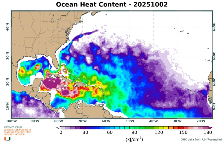
The next couple of weeks look quiet for Atlantic hurricane activity. Thereafter, it looks like convectively active phase of the Madden-Julian Oscillation will move into the Atlantic, and hurricane activity should pick back up mid-to-late Sep. Enjoy the quiet period while it lasts!
24.08.2025 15:49 — 👍 15 🔁 5 💬 0 📌 0
Usually find 900 or 850 mb to be a good level to choose.
18.08.2025 18:52 — 👍 1 🔁 0 💬 0 📌 0
Background low-level flow, so the component steering the storm.
18.08.2025 17:31 — 👍 1 🔁 0 💬 1 📌 0
3) Research has shown that low-level flow that is oriented opposite of the shear direction (e.g., Lee et al. 2021), which is the case for Erin, tends to blunt the effects of vertical wind shear by allowing surface heat fluxes to mitigate the effects of downdrafts and sustain eyewall convection. (4/)
18.08.2025 15:54 — 👍 6 🔁 0 💬 1 📌 0

2) Hurricane Erin's upshear environment (northern half of the storm) is pretty moist in the middle troposphere. Vertical wind shear weakens hurricanes by pushing dry air into their core (i.e., ventilation). Without a reservoir of dry air that's able to get in, ventilation is minimized. (3/)
18.08.2025 15:54 — 👍 5 🔁 0 💬 1 📌 0

1) Hurricane Erin has grown large in size. Hurricane-force winds extend 80 miles from the center, and tropical-storm force winds extend 230 miles from the center. Larger hurricanes tend to be more resilient to vertical wind shear and have larger area of surface heat fluxes to gather energy. (2/)
18.08.2025 15:54 — 👍 5 🔁 0 💬 1 📌 0

Despite 29 knots of analyzed vertical wind shear, which is in the high range, Hurricane Erin has restrengthened after completing an eyewall replacement cycle. It has been resilient to shear due to possibly a few reasons. (1/)
18.08.2025 15:54 — 👍 31 🔁 7 💬 1 📌 0


NOAA Doppler radar analyses from reconnaissance flights yesterday morning and this morning show the transformation of Hurricane Erin as it evolves. The very compact, intense wind field has become a broader, less intense wind field. The result of an ongoing eyewall replacement cycle.
17.08.2025 16:15 — 👍 26 🔁 5 💬 0 📌 0
Incredible video of the eye of Hurricane Erin, taken from the cockpit of NOAA reconnaissance aircraft.
16.08.2025 21:24 — 👍 4 🔁 0 💬 0 📌 0
It is a blessing that Erin is not a couple of degrees latitude farther south than it is.
16.08.2025 18:49 — 👍 1 🔁 0 💬 0 📌 0
Hurricane forecast models correctly showed Erin would undergo rapid intensification, though the devil is in the details. Hats off to some of the earlier runs of the COAMPS-TC model, which got both the onset and extreme rate of intensification correct. That's very challenging to predict.
16.08.2025 18:40 — 👍 14 🔁 0 💬 0 📌 0
This is a remarkable image from the NOAA-P3 #Hurricane Hunters in #Erin.
You can actually see the wind speed gradient by the color of the ocean as you go from extreme #eyewall winds to the relative calm of the #eye.
Incredible images & data from @noaa.gov @nws.noaa.gov
16.08.2025 14:10 — 👍 154 🔁 66 💬 4 📌 0
Reminds me of Hurricane Milton at its peak intensity last year.
16.08.2025 16:14 — 👍 3 🔁 0 💬 0 📌 0
Senior Climate+Weather Director @ CNN
Satellite meteorologist, NOAA Cooperative Institute for Meteorological Satellite Studies, University of Wisconsin - Madison. Personal account, all opinions ©2025. Woke af. DEIA hire. MAGA is a cult.
🏢: Atmospheric scientist and educator. 😀: Sports, computer ratings, and rain. ☕️: Just happy to be here.
@ClimateCentral.org VP, Chief Meteorologist, #ClimateMatters Director
Proud #PennState Alum, Twin Mom, #StubbornClimateOptimist
#Unless #ShowYourStripes #GSD
Climate reporting & other stuff for @NPR https://www.npr.org/people/384067907/rebecca-hersher
Signal: rhersher.01
📧: rhersher@npr.org
☎︎: 202-845-3931
Atmospheric scientist researching tropical meteorology and climate
Meteorologist, code monkey, gratuitous wanderer. skyinmotion.com
pizza, weather, hockey and other delights.
Weather-Climate continuum scientist. WTW research network fellow. Yorkshire born and bred. Done sounds like Cone.
Atmospheric Scientist in Monterey, CA
Hurricanes and Arctic Cyclones
🏳️🌈
25 Year veteran insurance industry meteorologist. Natural hazards, weather, climate, catastrophe risk management and modeling. Building codes and resilience. Expect the occasional pupnado pic. Meteorologist for Munich Re US. All opinions my own. 🏳️🌈🇺🇦
Meteorologist (RA) | Python-smithy on some days? | short-term, high-impact weather w/ CAMs | M.S. (2018) at @miamirosenstiel.bsky.social | Husband | Latino | Racing aficionado. All opinions my own & not my employer’s.
Weather Strategist, Atmospheric Scientist, consultant, youth coach - XC, basketball, soccer
Personal account, views my own, you know the drill. Techniques Development Meteorologist for the Storm Prediction Center.
See more of my photography:
https://www.instagram.com/keltore
My blog:
https://www.stormscale.io
Assistant Professor in the Department of Atmospheric Sciences at the University of Utah studying extreme weather and climate.
All opinions are my own
Atmospheric Science Professor. Interested in all things clouds and storms using data science, modeling, and observations. tobac core team. Views mine, not my employer’s.