This article is in the paper copy of the FT today, which is nice :)
Quite chuffed that my little data analysis project has ended up in a national newspaper. And I think it's an important topic too.
#uk #health #pharmacy #data #datanalysis
05.02.2026 09:11 — 👍 0 🔁 0 💬 0 📌 0

Number of late-night pharmacies in England plummets
[FREE TO READ] Decline comes after cash-strapped chemists reduced opening hours to cut costs
Did you know that the number of pharmacies in England open after 9pm has decreased by 95% in just three years?
I did some data analysis on this, inspired by needing an out of hours pharmacy over Christmas, and it has been featured in the Financial Times today: as.ft.com/r/4333cab1-6...
04.02.2026 16:59 — 👍 8 🔁 6 💬 1 📌 2
15379 emails, 251 unread
27.01.2026 14:55 — 👍 0 🔁 0 💬 0 📌 0

2025 GDAL User Survey
In 2024, the GDAL User Survey solicited feedback to help focus GDAL Sponsorship Program activities. Your contribution mattered. Last years' results triggered the project to embark on the GDAL CLI Mode...
2025 GDAL User Survey is now active for the entire month of December! Visit gdal.org/survey/ & tell the project how you use it, where you get help, what it should do in the future, & how/if it should use LLMs going forward. (optionally) give us your email, we'll even enter you to win a GDAL t-shirt!
01.12.2025 15:32 — 👍 6 🔁 14 💬 0 📌 1
...where it took me 30mins via a couple of outside streets to get from one conference room to another. Etc.
20.11.2025 09:41 — 👍 4 🔁 0 💬 0 📌 0
Totally - I've found this a big problem. I can list off the conferences where it took 20mins from the conference room to get to an accessible toilet, the one where I had to ask a security guard every time I wanted to go to the toilet...
20.11.2025 09:41 — 👍 5 🔁 0 💬 1 📌 0
Yes though I was brought up bringing it to the boil on the hob. Only started using a kettle once I met my wife
03.11.2025 17:52 — 👍 0 🔁 0 💬 0 📌 0
YouTube video by FOSS4G:UK
Welcome to FOSS4G:UK 2025
We have now uploaded all the recorded sessions from #FOSS4GUK 2025 in Leeds. 📹🦉
We would now invite everyone else to our youtube channel if you would like to catch up on the 35 recorded session.
www.youtube.com/watch?v=qCKv...
17.10.2025 16:05 — 👍 4 🔁 5 💬 0 📌 0

Very proud of my former student (now colleague!), Gabi, who just gave her first conference presentation at #foss4guk in Leeds.
#geospatial #gis #osgeo #postgis
01.10.2025 10:44 — 👍 3 🔁 1 💬 0 📌 0
gdal raster neighbors — GDAL documentation
The new 'gdal raster neighbours' function is pretty cool - it does convolution across a raster, with configurable kernels and other options. Not yet released, but available in dev builds. See gdal.org/en/latest/pr... for details.
30.09.2025 16:27 — 👍 4 🔁 1 💬 1 📌 0
Looking forward to #foss4guk this week in Leeds.
I'll be attending with a colleague, running a workshop on producing live vector tiles from PostGIS and my colleague will be giving a talk.
Now just to hope that the trains work better than last year: I got stuck in Bristol TM because the lift broke!
28.09.2025 18:51 — 👍 2 🔁 0 💬 0 📌 0
Debated about buying some heavy water today...for my #emfcamp talk/demo but a) it's very expensive and b) it'd probably get me put on a list. I'm consoling myself by buying high wattage halogen lamps instead.
27.09.2025 22:11 — 👍 1 🔁 0 💬 1 📌 0
This is one of the weirder comments that I've made on BlueSky, but...we have that Z80 chopping board!
07.09.2025 16:42 — 👍 1 🔁 0 💬 1 📌 0
(Partially prompted by reading Exploding the Phone, a good book about phone phreaking in the US, and realising that from that and various other similar books - eg. Kevin Mitnick's - I know significantly more about the US phone network than the network in my own country!)
23.08.2025 17:34 — 👍 1 🔁 0 💬 1 📌 0
Does anyone know any good books about the UK telephone network? Ideally I'd be interested in a history of the network, exchange development, memories of working on the network, big events (eg. phONEday etc) - but I can't seem to find anything like this
23.08.2025 17:34 — 👍 0 🔁 0 💬 1 📌 0

Orbio Earth just open-sourced their full methane detection pipeline—models, tools, synthetic-plume engine & validation notebooks—for Sentinel-2, Landsat 8/9, and EMIT. #Methane #ClimateTech #OpenSource - orbio-earth.github.io/Project-Euca...
08.08.2025 15:46 — 👍 12 🔁 4 💬 0 📌 0
I'm also quite surprised that I hadn't come across this previously, having been working in geospatial for quite a long time. Every day is a day for learning!
07.08.2025 15:23 — 👍 0 🔁 0 💬 0 📌 0

So, TIL that a MultiPolygon is invalid if any of its polygon parts touch at more than a single point. Eg. a MultiPolygon where two 'polygon parts' share an edge is invalid.
I can see why this is the case - those two polygon parts should be merged, but it's a bit annoying.
#gis
07.08.2025 15:22 — 👍 3 🔁 0 💬 1 📌 0
I won't be able to make this as my wife is in the US at the time and so I'm needed at home - but I've had a great time at PyCon UK in the past, and I'm already looking forward to watching the videos of some of these talks.
05.08.2025 18:57 — 👍 1 🔁 0 💬 0 📌 0
Gabi, a MSc student I've been supervising, will also be giving a talk about developing a system to look at secondary flooding impacts, specifically loss of power and loss of road access, on businesses in the UK. She'll be covering use of pgRouting, complex PostGIS SQL queries etc. #foss4guk
05.08.2025 18:33 — 👍 0 🔁 0 💬 0 📌 0
Pleased to announce that I'll be giving a workshop at #foss4guk entitled 'Live Vector Tiles from PostGIS with pg_tileserv: A Hands-on Workshop' - I'll take you through the full process of using pg_tileserv to serve vector tiles to web maps (using MapLibre, Leaflet etc) and QGIS. Come along!
05.08.2025 18:32 — 👍 1 🔁 0 💬 1 📌 0
I might have to steal one of their section headers as my tagline, as I tend to refer to myself as a geospatial software engineer: 'Geospatial software engineering as its own weirdo niche'
#gis
04.08.2025 20:57 — 👍 0 🔁 0 💬 0 📌 0
Placing Technologies
The latest entries posted on Placing Technologies
The Placing Technology blog (placing.technology) is utterly fascinating - someone blogging parts of their PhD research about the history of GIS and geospatial technologies in general.
04.08.2025 20:56 — 👍 1 🔁 0 💬 1 📌 0
I don't normally write long threads, but was suddenly inspired. Hope that helps @ajgwords.bsky.social - I'll be attending FOSS4G UK (and presenting myself), so hopefully I'll be able to hear the talk!
04.08.2025 13:23 — 👍 2 🔁 0 💬 1 📌 0
It needs to have changed a lot from my days as an undergraduate (~20 years ago - ugh!), but I suspect it either hasn't changed that much, or the sort of things you can do in an undergrad practical session don't let you explore what is *really* done in RS any more.
04.08.2025 13:23 — 👍 0 🔁 0 💬 1 📌 0
now with cloud-based systems, STAC and so on. I'm not sure how we should deal with this as a community, and I'm not sure how modern methods will 'trickle down' to non-code based environments. Like, what do you do in an undergrad RS practical session these days? 8/n
04.08.2025 13:22 — 👍 0 🔁 0 💬 1 📌 0
4) There's a big gulf between what is possible with remote sensing if you can write code, and what is possible if you can't. That's fine for me - I can write code and enjoy doing so - but not everyone can or wants to, and that limits what you can do hugely. Potentially that applies even more 7/n
04.08.2025 13:21 — 👍 1 🔁 0 💬 1 📌 0
3) Practical remote sensing is often taught poorly, and often taught using inappropriate software. It's a long time since I've taught remote sensing at uni level, but back then and still now I keep coming across massively silly ways of teaching you how to actually do stuff with RS data 6/n
04.08.2025 13:20 — 👍 0 🔁 0 💬 1 📌 0
2) Loads of methods are developed using very high resolution data which can be a problem because the data is *really* expensive (sometimes you can get it free in academia), making those methods too expensive to use in the real world. Often high-res data isn't actually needed - it's 'too high' 5/n
04.08.2025 13:19 — 👍 2 🔁 0 💬 1 📌 0
We are Infrastructure Club and we are here to send you tweets about cranes and stuff.
Join our slack community!
🌎 https://infrastructureclub.org
🐘 https://chaos.social/@infraclub
🐤 https://twitter.com/infraclub
She/her. Warwickshire. Disabled mama, formerly of Ravelry, 4rthur, b3ta, Ouch, and blogger. I have a husband and a 9yo son.
BAFTA for best writer lol.
Wood working, 3D printing and general all around tinkerer
Software Engineer @Microsoft || Maker || Girls STEM Scholarship creator National VideogameMuseum || Electronics || LEGO Master || Cosplay || 3DPrint || 🦄 🛰️ Hacker || Past Marvel
https://www.AmieDD.com
Links: https://amiedd.tech/
Ancient nerd, lover of all things (in no particular order) 3D Printing, Astronomy, aviation, and cars.
Electronics engineer. RISC-V ASICs at IQonIC Works 🧙♂️ (He/Him)
I also take macro photos of electronics
Engineer and technical journalist.
Contributing editor and European correspondent, Hackaday.
Hackerspaces, Parkour, Trans Rescue.
Tall, She/'Er. 🏳️⚧️
https://ko-fi.com/jennylist
@jennylist@mastodon.social
Tinkerer Maker Solderer Mom • lateral thinker • LEDs improve everything • she/her
Maker of marginally useful things, creator of
@rpilocator.com , Raspberry Pi wrangler, cyclist at heart. 🇧🇷🇺🇸
YouTube: youtube.com/@makerbymistake
vintage computers, tubes, the MOnSter6502, cross-sectioned electronic parts, capacitors, and other detritus. coauthor of http://nostarch.com/open-circuits
Peace, Love & Linux. Strictly personal opinions. #PostgreSQL Significant Contributor & speaker.
Author of PostgreSQL Mistakes and How to Avoid Them: https://hubs.la/Q03Nc0hv0
Co-author of the PostgreSQL 16 Administration Cookbook: http://packt.link/6PurB
Mapping the world with Python. Geospatial data scientist who likes maps.
Contact adam@pythonmaps.com
Water and Climate Scientist, python, gdal, desperate to leverage open source solutions in the private sector
Opinions are mine alone
Former academic geologist, now geospatial professional interested in all things Open Source and Earth Observation.
Living in Edinburgh, Scotland. Was MindOverMagma on Twitter and Mastodon and seeing what the geospatial community on here is like 🗺️🛰️🌍🌳
A mapish developer working at GeoCat. Active with the OSGeo and LocationTech communities working on a wide range of free and open source geospatial goodness!
Geospatial problems solver.
All my stuff is posted using farm-to-table WiFi, free-range 5G or locally-sourced Ethernet.
Specialization is for insects.
nimbi.es
Official account of Southampton City Council
https://linktr.ee/southamptoncc
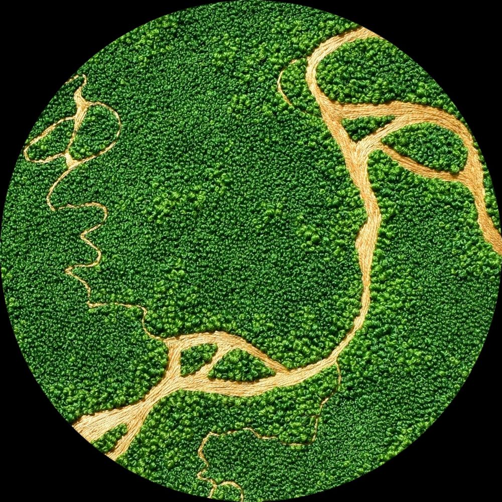
I make aerial embroidery landscapes 🧵✈ Queer, autistic and obsessed with green! All my current and previous work is on my site: https://victoriaroserichards.co.uk/
Apparently, everybody's favourite. Him off Tech Diff. The begrudging second coming of Harry Secombe. Strong wahey energy. Funniest British Man (TM). The Lidl of Light Entertainment.