still in college but im going to not so active here. Decided not to be active here for a little while but I’ll try to be here soon.
19.10.2025 16:48 — 👍 0 🔁 0 💬 0 📌 0
the half term is approaching, soon a few post will be added here until I am back off to be more focused on colleg.
09.10.2025 23:16 — 👍 0 🔁 0 💬 0 📌 0
Hello all, sorry that I haven’t active at all on the platfor.
I got very busy of the couple of weeks. due to college. Don’t worry I am here i promise I will be more active here
28.09.2025 22:17 — 👍 0 🔁 0 💬 0 📌 0
Hi how we all doing today
12.09.2025 21:07 — 👍 0 🔁 0 💬 0 📌 0
Winter updates are coming very soon. be on the look out!
05.09.2025 17:04 — 👍 0 🔁 0 💬 0 📌 0


Tomorrow will we will see a day of heavy rain showers and thunderstorms on Wednesday some of this showers could produce some hail and a possible tornado.
The winds are also going to be strong so the showers should move through quite quickly.
The biggest risk is east Anglia and the south east.
02.09.2025 19:02 — 👍 0 🔁 0 💬 0 📌 0


Showers will develop widely tomorrow throughout the afternoon on Monday.
Some of the showers could become heavy and even thundery in some areas.
The most thundery showers could be in east Anglia and the south East of England .
31.08.2025 21:15 — 👍 0 🔁 0 💬 0 📌 0
Not much with the weather but I will post a weather update later
31.08.2025 19:36 — 👍 0 🔁 0 💬 0 📌 0
NEXT SUNDAY:
The UK’s emergency alert test is coming next week on Sunday 7th September at 3PM.
30.08.2025 14:14 — 👍 0 🔁 0 💬 0 📌 0
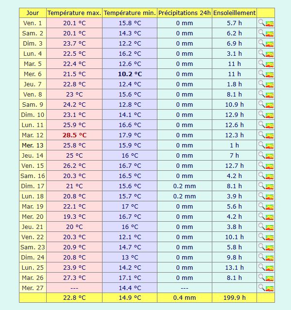
It has been a very dry August so far in East Kent. Manston is only on 0.4 mm - this would likely be the driest August on record at Manston since 1940 if it were to continue but the weekend is likely to spoil that statistic.
27.08.2025 17:46 — 👍 3 🔁 1 💬 1 📌 0

There Remains of hurricane Erin now as an area of low pressure will move into the Uk on Thursday which will bring welcome showers to parts of England where the drought has continued throughout much of the summer and spring this year.
This will be great for gardens and crops.
25.08.2025 22:23 — 👍 0 🔁 0 💬 0 📌 0
As you are aware,
We have a national emergency alert test coming on the 7th September
18.08.2025 17:38 — 👍 0 🔁 0 💬 0 📌 0
Weather update incoming in 1 hour.
the heatwave finally starting to slowly ease down from today and from yesterday.
I will give you the full update then
13.08.2025 21:44 — 👍 0 🔁 0 💬 0 📌 0
There has been a lot of wildfires out across southern southeastern and western parts of Europe yesterday.
More fires could be coming in the next few days as the heat wave continues until Friday.
If you see a wildfire call the following numbers
UK: 999
EU:112
12.08.2025 23:58 — 👍 0 🔁 0 💬 0 📌 0

Storm Erin has now formed in the Atlantic Ocean near to Cobo Verde islands.
We will see where this goes from here. I will keep you posted on any significant updates.
11.08.2025 15:20 — 👍 0 🔁 0 💬 0 📌 0

Quite the extreme heat index maps being shown tomorrow, the 12th of August as it shows of an index of 50C in the western and south western parts of France.
This level of heat can be extremely dangerous to fit and vulnerable people
11.08.2025 10:25 — 👍 0 🔁 0 💬 0 📌 0

The GFS 18Z is very similar to the GFS 06Z.
The GFS suggests a temperature of 45C in south western France and temperatures of 40+C more wildly on Monday and Tuesday.
It is possible that the temperature may get to 46C.
So there is a lower likelihood of the record to be broken is there 🔥🥵
10.08.2025 23:11 — 👍 0 🔁 0 💬 0 📌 0

This heat will be brutal to most parts in France on the 11 and the 12 August as the GFS suggests heat as of 45C. This is not normal heat summer but I will keep an eye if this upgrades or downgrades
People who say “this is summer” is wrong
10.08.2025 11:21 — 👍 1 🔁 0 💬 0 📌 0
Hi I’m suit.
My other account got deleted because of no activity on there.
So this account is now my official blue sky account
10.08.2025 11:05 — 👍 0 🔁 0 💬 0 📌 0
13y old Programmer and Weather Enthusiast from Boston, Lincolnshire in the UK.
Founder of FinchillaNET and snowwatch.org • Interests are meteorology; snow, thunderstorms, photography, cycling and the outdoors. More stuff on https://dlukefinch.uk
2023 was Netweather's 20th year! We're a leading independent UK weather forecasting co, run by a small, friendly team. https://www.netweather.tv
Amateur weather enthusiast from Wakefield. Providing balanced UK weather commentary, frequent severe weather updates, model insights & severe weather graphics.
Met Office weather presenter & meteorologist
Here for the F1 chat too
Steve Amateur weather enthusiast, tradesman, sports fan .
Weather shenanigans et al https://patreon.com/TheSnowDreamer?utm_medium=clipboard_copy&utm_source=copyLink&utm_campaign=creatorshare_fan&utm_content=join_link
Forecasting Thunderstorms & Convective events within the British Isles. Forecasted by a small group of amateur meteorologists.
A privately supported organisation, founded in 1974, which carries out research into high impact convective weather in the UK.
www.torro.org.uk
Weather forecasts for #London #Essex #Kent #Sussex #Suffolk #Norfolk. Readings taken from a PWS on Canvey Island.
Latest weather news and views from Brian Gaze,
TheWeatherOutlook's (TWO) founder. TWO provides short, medium and long range weather forecasts.
https://www.theweatheroutlook.com/
Weather infusiast and forecaster
Photography 📸
Forest you reds 🔴🔴
Follow my X
Weather account: https://x.com/WeatherFrog_?t=IyO3b69whENpEwVM36ETug&s=09
Youtube channel https://youtube.com/@superjos-r1d?si=0VUbWem_WcPzX45I
Stanton Hill Nottinghamshire
Met Office Deputy Chief Meteorologist @metoffice.gov.uk ⛅
Weather Images Editor, RMetS journal "Weather" https://www.rmets.org/weather 📖
Research: http://tinyurl.com/wxresearch 📈
Storm Chaser 🌩🏃
Own views
NW England weather forecaster based in Oldham.
Site Investigator for TORRO UK.
Weekly Blog: https://oldhamweather.blog/
That in the sky is a contrail. Nothing else.
BBC TV & Senior Weather Presenter. Reporter & documentary maker. Forever hiding in the shade ☁️barra.best@bbc.co.uk
Met head, weather fella. Likes sport and food too. You’ll see me on Met Office social media channels.
Head Meteorologist at MetSwift, working to revolutionise delivery of weather information.
LinkedIn: https://t.co/pUCAQfAfRP
Mad into weather and tech capturing any interesting sky phenomena.
Passionate about volcanoes, extreme weather & wildfires. If it's exciting, informative, or unique, I'll share it. © to owners! DM for credit/removal/submission.
Latest short, medium and long range weather forecasts for the UK from GavsWeatherVids (GWV) owner Gavin Partridge.
Find all our daily weather videos here: https://www.youtube.com/c/GavsWeatherVids