So, I LOVE this WPC site that just showed up for comment in a PNS. www.wpc.ncep.noaa.gov/urrd/
16.09.2025 19:25 — 👍 19 🔁 3 💬 1 📌 0
@codysnell.bsky.social
NWS Meteorologist for the Weather Prediction Center/ UMD Alum
So, I LOVE this WPC site that just showed up for comment in a PNS. www.wpc.ncep.noaa.gov/urrd/
16.09.2025 19:25 — 👍 19 🔁 3 💬 1 📌 0
Hydrangeas are happy this summer. 😎
09.08.2025 00:14 — 👍 0 🔁 0 💬 0 📌 0[Delayed Report] On Jul 31, at 5:20 PM EDT, 1 ENE Mount Airy [Carroll Co, MD] Emergency Mngr reports Flash Flood. *** 1 Fatal *** 13 yr old boy swept into storm drainage. #mdwx Link
01.08.2025 12:08 — 👍 0 🔁 1 💬 0 📌 0
Flooding fatality from today’s storms in central MD. Reported that a child was swept away while playing outside. 😢 www.wmar2news.com/local/child-...
01.08.2025 00:51 — 👍 3 🔁 2 💬 0 📌 0Sykesville Mesonet up yet?
31.07.2025 20:43 — 👍 0 🔁 0 💬 1 📌 0

The summer of flooding continues… ☔️⛈️
30.07.2025 19:59 — 👍 3 🔁 1 💬 0 📌 0🌍 M8 earthquake near 136 km ESE of Petropavlovsk-Kamchatsky, Russia at 2025-07-29 23:24 UTC
More info:
https://earthquake.usgs.gov/earthquakes/eventpage/us6000qw60

Neat! ☔️🌧️🚣
24.07.2025 18:08 — 👍 5 🔁 2 💬 0 📌 0
The ERO from last night for better context…
22.07.2025 00:48 — 👍 1 🔁 0 💬 0 📌 0Over 13” of rain last night in IL.
22.07.2025 00:45 — 👍 3 🔁 2 💬 1 📌 0
Pattern has been ripe for more flash flooding… this time in the Ohio Valley and Midwest. Could be some big rainfall totals somewhere over the next few days.
19.07.2025 18:10 — 👍 3 🔁 0 💬 0 📌 1Unfortunately two fatalities associated with flash flooding in NJ yesterday. Reminder that most flash flooding fatalities in the U.S. are associated with vehicles.
15.07.2025 15:36 — 👍 7 🔁 2 💬 0 📌 0Heavy rain and rush hour traffic going about as you’d think it would in the DC area this evening.
14.07.2025 22:05 — 👍 4 🔁 1 💬 0 📌 0Thankfully this graphic is scheduled to have a facelift next week! Can’t guarantee all the heat areas will go away…
16.06.2025 20:16 — 👍 5 🔁 0 💬 1 📌 0*lightning bug
16.05.2025 01:15 — 👍 2 🔁 0 💬 0 📌 0
IEMBot Image TBD
LWX issues Flash Flood Emergency [flash flood: observed, flash flood damage threat: catastrophic] for Greene [VA] till May 14, 12:45 AM EDT Link
14.05.2025 01:35 — 👍 1 🔁 1 💬 0 📌 0Significant flash flooding event starting to unfold across central VA.
13.05.2025 22:53 — 👍 2 🔁 0 💬 0 📌 0Marty!!
30.04.2025 12:11 — 👍 2 🔁 0 💬 0 📌 0
Growing wildfire southeast of Shippensburg, PA this afternoon. Seems to be located in a large wooded area.
24.04.2025 21:10 — 👍 1 🔁 0 💬 0 📌 0(these results are an outcome of federal investments in research and people over many years.)
06.04.2025 22:09 — 👍 11 🔁 1 💬 0 📌 0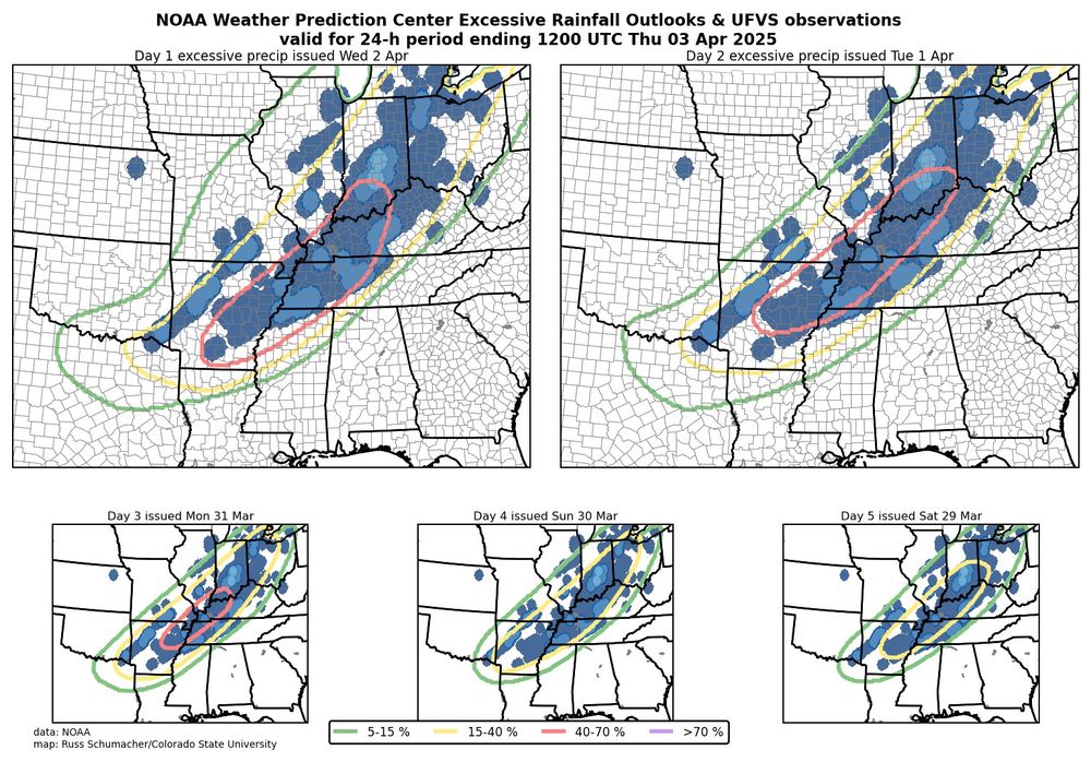
NOAA Weather Prediction Center Excessive Rainfall Outlooks all valid for 2-3 April 2025. The outlooks were very consistent in their location and the observed flooding occurred essentially right in the locations where the outlooks showed the highest probabilities.
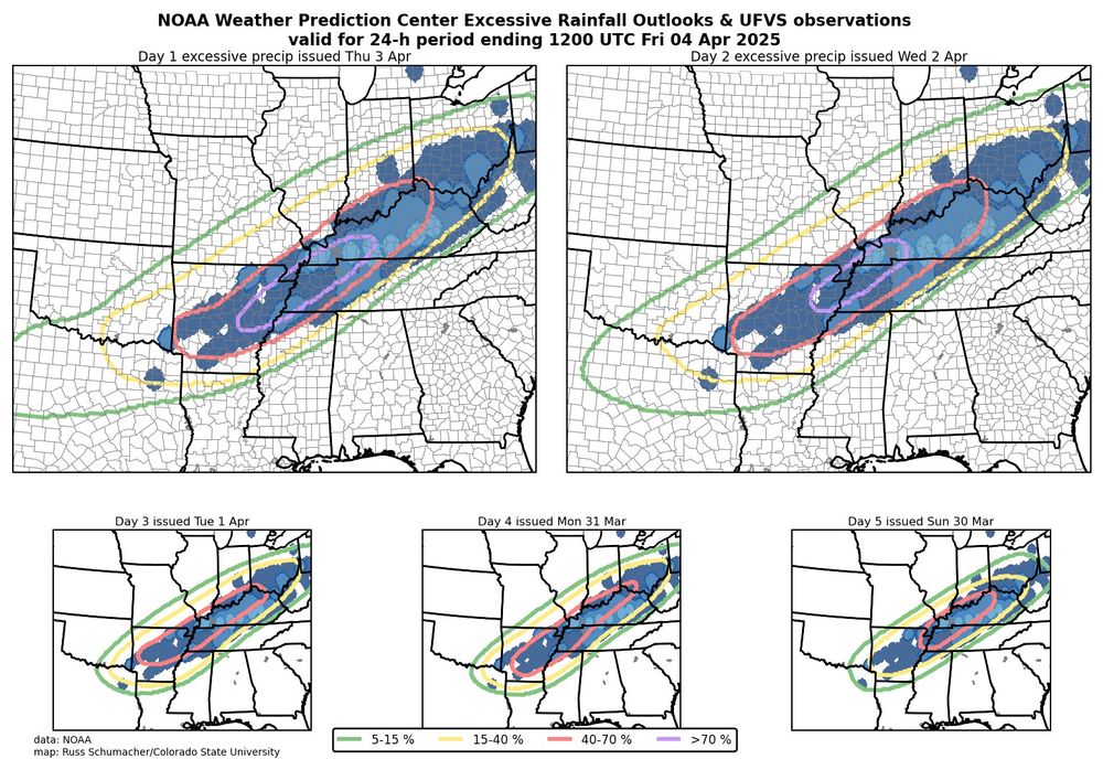
NOAA Weather Prediction Center Excessive Rainfall Outlooks all valid for 3-4 April 2025. The outlooks were very consistent in their location and the observed flooding occurred essentially right in the locations where the outlooks showed the highest probabilities.
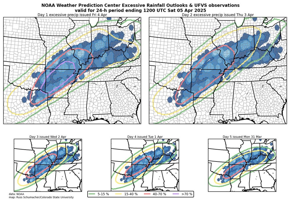
NOAA Weather Prediction Center Excessive Rainfall Outlooks all valid for 4-5 April 2025. The outlooks were very consistent in their location and the observed flooding occurred essentially right in the locations where the outlooks showed the highest probabilities.
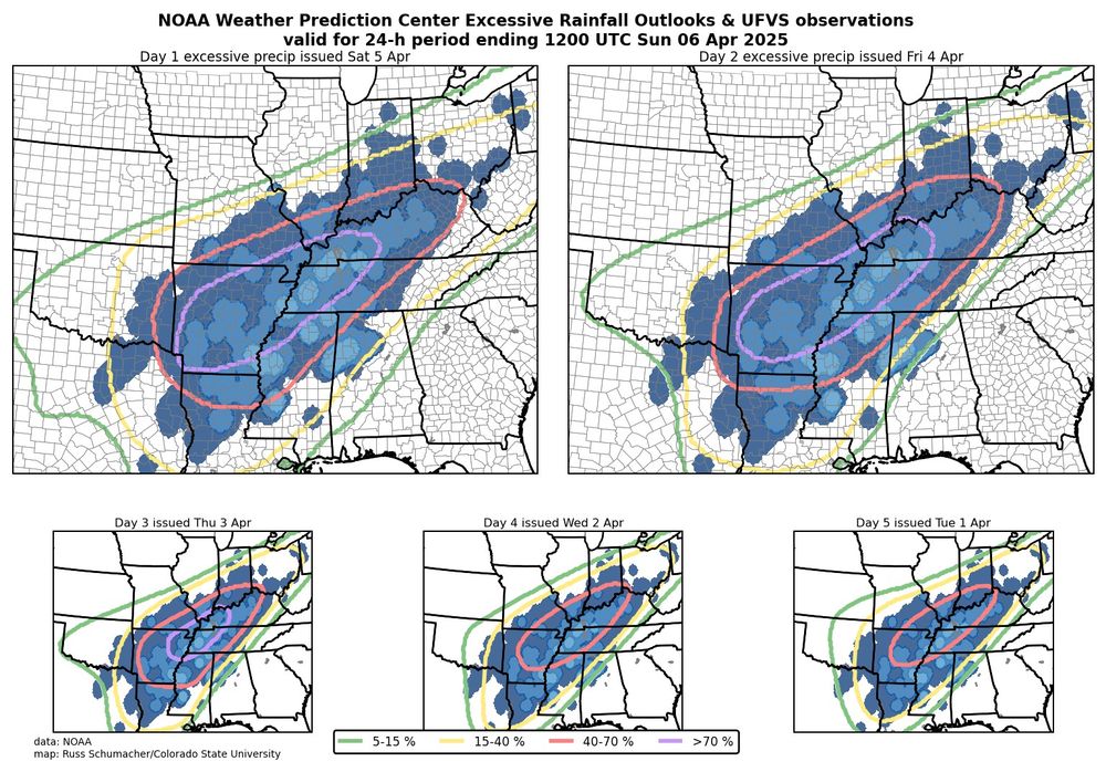
NOAA Weather Prediction Center Excessive Rainfall Outlooks all valid for 5-6 April 2025. The outlooks were very consistent in their location and the observed flooding occurred essentially right in the locations where the outlooks showed the highest probabilities.
We often (rightly) see maps like these showing how good SPC convective outlooks are; let's also give some kudos to WPC for some outstanding excessive rainfall outlooks for this event. Especially impressive are the day 5 outlooks, giving advance notice of prolonged excessive rainfall and flood risk.
06.04.2025 22:00 — 👍 92 🔁 30 💬 1 📌 0

Flood/flash flood reports as well as top rainfall reports going back to last Wednesday. Over 15 inches in parts of western Kentucky. ☔️🌧️
06.04.2025 15:09 — 👍 17 🔁 7 💬 1 📌 0FFE for Little Rock, AR
05.04.2025 16:15 — 👍 1 🔁 1 💬 0 📌 0First FFE from the Paducah office for this event.
05.04.2025 00:19 — 👍 15 🔁 5 💬 1 📌 1
Excessive rainfall event just getting started in the Mid-South. (18z HRRR through tomorrow)
04.04.2025 19:36 — 👍 2 🔁 0 💬 0 📌 0Many areas hit by yesterday’s tornado outbreak now expected to go through “significant and life-threatening flash flooding” today.
03.04.2025 17:12 — 👍 1 🔁 1 💬 0 📌 0First of what will be many MPDs from WPC over the next few days. “Flash Flooding Likely” and sadly going to prime the soils for more severe flooding impacts.
02.04.2025 20:17 — 👍 1 🔁 0 💬 0 📌 0Can’t really sound the alarm more than a day 3 high risk of excessive rainfall.
01.04.2025 19:42 — 👍 1 🔁 0 💬 0 📌 0
Heavy rainfall threat this week. (Via WPC social media)
30.03.2025 18:20 — 👍 2 🔁 1 💬 0 📌 0