WORLD CLIMATIC HISTORY REWRITTEN
Record warm nights falling allover the Hemisphere
❗️INCREDIBLE MINIMUM
30.4 Khor Fakkam EMIRATES
29.4 Abu Musa IRAN
29.2 Qaboos Port OMAN
and
28.9 Ca Mau VIETNAM
27.2 Dhaka BANGLADESH HOTTEST NOVEMBER NIGHT EVER
Tropical nights in Europe
Mental
01.11.2025 07:18 — 👍 56 🔁 25 💬 0 📌 4

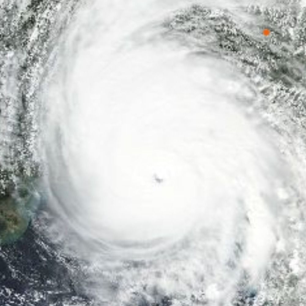
Copernicus Sentinel-2 Sat of Melissa
x.com/forecaster25...
28.10.2025 22:28 — 👍 14 🔁 5 💬 0 📌 1
The eye of Major Hurricane Melissa has wasted no time warming again after it closed during its passage over the complex terrain of Jamaica. A nice new burst of convection in the eyewall as well. The question is how much she can re-organize and re-strengthen prior to Cuba.
28.10.2025 22:48 — 👍 26 🔁 8 💬 0 📌 2

...CATEGORY 5 MELISSA MAKES LANDFALL IN JAMAICA...
...ONE OF THE MOST POWERFUL HURRICANE LANDFALLS ON RECORD IN THE ATLANTIC BASIN...
Melissa has made landfall in southwestern Jamaica near New Hope with estimated maximum sustained winds of 185 mph (295 km/h) and an estimated minimum central pressure of 892 mb (26.34 inches).
THIS IS AN EXTREMELY DANGEROUS AND LIFE-THREATENING SITUATION! DO not leave your shelter as the eye passes over, as winds will quickly, and rapidly increase on the other side of the eye.
Residents should remain in place through the passage of these life-threatening conditions. To protect yourself from wind, the best thing you can do is put as many walls as possible between you and the outside. An interior room without windows, ideally one where you can also avoid falling trees, is the safest place you can be in a building. You can cover yourself with a mattress and wear a helmet for added protection.
The next position update will be provided with the intermediate advisory at 200 PM EDT (1800 UTC) .
SUMMARY OF 100 PM EDT...1700 UTC...INFORMATION
LocatIoN..18.1N 78.0W
ABOUT 25 MI...40 KM SE OF NEGRIL JAMAICA ABOUT 145 MI...235 KM S OF GUANTANAMO CUBA MAXIMUM SUSTAINED WINDS...185 MPН...295 KM/H
PRESENT MOVEMENT... NNE OR 25 DEGREES AT 9 PH...15 KM/H MINIMUM CENTRAL PRESSURE...892 MB...26.34 INCHES

Visible satellite image of Melissa at 1:01pm EDT, October 28.
#Melissa makes landfall in southwestern Jamaica near New Hope as a powerful category 5 hurricane. For the latest updates visit hurricanes.gov
28.10.2025 17:06 — 👍 167 🔁 75 💬 5 📌 12

This is hands down the most extraordinary dropsonde in Atlantic recon history.
28.10.2025 14:18 — 👍 113 🔁 35 💬 2 📌 10
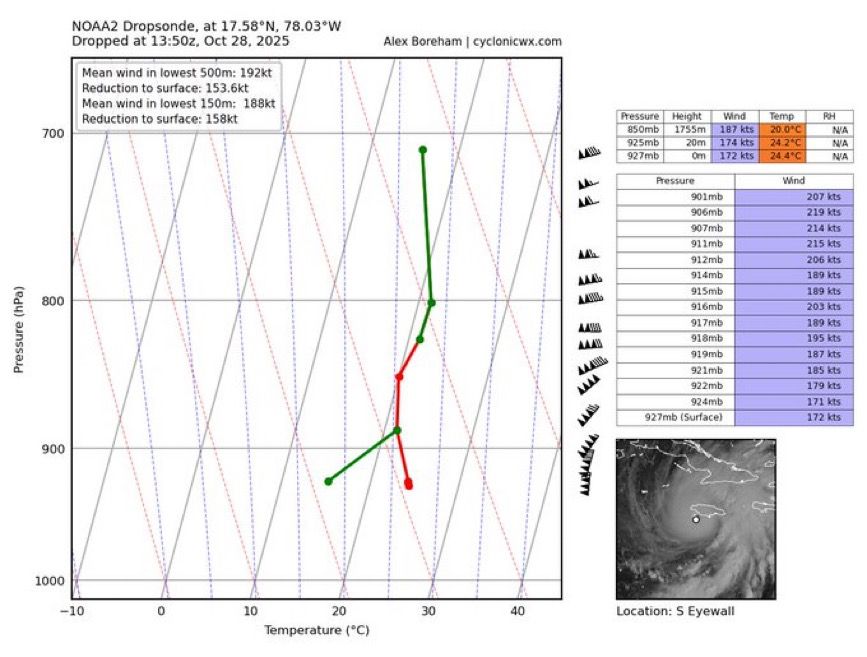
Wow. This is easily the most ridiculous dropsonde I’ve ever seen.
188 knot mean winds in the low-levels with gusts over 250 mph
Absolutely scary and historic hurricane headed into SW Jamaica this morning
28.10.2025 14:21 — 👍 86 🔁 38 💬 5 📌 8
The eye of extremely powerful Major Hurricane Melissa, one of the most intense tropical cyclones ever observed in the Atlantic basin, is now imminently about to begin coming on-shore. Her powerful eyewall containing destructive winds now lashing (W) Jamaica. Terrible, absolutely terrible.
28.10.2025 13:43 — 👍 6 🔁 3 💬 0 📌 0
October 28 9:00am ET: #Melissa is now a 180 mph storm with a central pressure down to 896 millibars.
Only 5 other known Atlantic storms have had stronger wind speeds (Allen, Dorian, Wilma, Gilbert, Labor Day (1935)).
2024 & 2025: First back-to-back years with <900mb Atlantic hurricanes on record.
28.10.2025 13:14 — 👍 24 🔁 17 💬 1 📌 2
#Melissa unfortunately is still intensifying. A 9am EDT Tropical Cyclone Update indicates that winds are up to 180 mph, with an estimated minimum pressure of 896 mb.
You can see how GLM lightning has 📈 in the past hour, encircling the eye, with eye WV temp still increasing!
28.10.2025 13:13 — 👍 155 🔁 60 💬 4 📌 9
This meso loop of #Melissa from CIRA is absolutely stunning at it makes its closes in on landfall in southwestern Jamaica.
rammb-data.cira.colostate.edu/tc_realtime/...
#hurricanemelissa
28.10.2025 12:52 — 👍 175 🔁 80 💬 8 📌 15

Line graph time series of annual mean sea surface temperature anomalies from 1982 to 2024 in the Caribbean Sea during September to November. There is a long-term increasing trend and 2024 is the warmest on record. Anomalies are relative to 1982-2010.
Here's a look at recent warming in the Caribbean during the September to November period since 1982. This is driven by human-caused climate change and fuels these powerful hurricanes. 🌊
More views at zacklabe.com/united-state...
28.10.2025 13:25 — 👍 157 🔁 74 💬 3 📌 4

Waiting on a dropsonde to confirm, but Melissa is most certainly below 900 hPa right now.
Tragically we are about to witness the 2nd or 1st deepest Atlantic hurricane landfall by min MSLP on record in Jamaica.
28.10.2025 12:41 — 👍 59 🔁 24 💬 4 📌 6
What we're witnessing with #Melissa is ultra rare in the history of known hurricanes in the Atlantic. This level of sustained intensity and feasting on every joule of ocean heat content without any real disruption is incredible.
Not hyperbole: Jamaica is facing a generational catastrophic event.
28.10.2025 02:23 — 👍 7747 🔁 3528 💬 347 📌 550

At 901 millibars minimum central barometric pressure, #Melissa is the strongest hurricane ever recorded so late in a season in the Atlantic. It is also the 8th strongest Atlantic #hurricane during any part of the season. It is now sadly moving north-northeast towards #Jamaica.
28.10.2025 07:17 — 👍 82 🔁 23 💬 3 📌 3

During Melissa’s rapid intensification the storm drifted slowly over exceptionally warm ocean waters that were 1.4°C (2.5°F) warmer than average — these conditions were made up to 700 times more likely because of human-caused climate change. (via @climatecentral.org) 1/2
28.10.2025 00:58 — 👍 92 🔁 42 💬 2 📌 3

The western end of Jamaica where #Melissa is projected to make landfall has the least well-built structures of anyplace on the island. Graphic is from a 2021 paper, "Poverty and hurricane risk exposure in Jamaica": www.researchgate.net/publication/...
28.10.2025 01:53 — 👍 419 🔁 192 💬 11 📌 16
From a crewmember on yesterday's Teal 74 mission into now-Category 5 Hurricane #Melissa. As clear of an eye as you will see in the Atlantic basin.
27.10.2025 16:11 — 👍 2795 🔁 1057 💬 53 📌 126
🚨 None of the UN IPCC models capture what NASA satellites are seeing.
We should assume and prepare for the worst, as there is a non-zero chance of 3°C of global warming by 2050.
We better assume that it will happen and/or try to make sure that it doesn't happen.
1/
13.10.2025 12:31 — 👍 93 🔁 49 💬 5 📌 1

🌊🌡📈 Sea Surface Temperature of the North Pacific is (still) off the chart.
It takes >3000 times as much heat to warm water than air.
Based on NASA observations, this rapid rate of warming is expected to continue.
What the Hell is Going On in the North Pacific?!
www.patreon.com/posts/139393...
04.10.2025 18:31 — 👍 123 🔁 63 💬 6 📌 4

Hurricane Gabrielle makes a run for the Azores » Yale Climate Connections
A hurricane watch is up, while two other Atlantic systems percolate, and far south China braces for Typhoon Ragasa.
Telltale sign of this odd Atlantic season: The #Azores are on track to experience a hurricane, #Gabrielle, before anyplace in North or Central America or the Caribbean. Meanwhile, Hong Kong and points west are bracing for #Ragasa, still at Cat 4 strength.
yaleclimateconnections.org/2025/09/hurr...
23.09.2025 21:09 — 👍 62 🔁 17 💬 0 📌 1
Now a Category 4, #Gabrielle's satellite presentation continues to improve. Great time to watch the mesoscale loop as the sun goes down!
22.09.2025 19:02 — 👍 54 🔁 9 💬 1 📌 0

Supertyphoon Ragasa now fixed at a mind-blowing 922 hPa/140kts and displaying structure indicative of this extreme strength. IR is making me think of that famous "skull" image from Matthew
21.09.2025 10:45 — 👍 28 🔁 8 💬 2 📌 2

‼️ABSOLUTELY UNBELIEVABLE
TROPICAL NIGHT AT 1800M IN AUSTRIA
Min 20.4 Hahnenkamm
Never happened 250+ years of Austria history ANYTIME ANYWHERE
No summer heat wave ever made what happened today. On Sept 20th!
One of the most extreme event Europe has ever seen.
Absolutely historic
20.09.2025 15:55 — 👍 76 🔁 35 💬 0 📌 7
SOUTH AMERICA HEAT WAVE
Brutal heat today with up to 43.4C at Base Jara in PARAGUAY
But this is JOKE to what's coming
The most insane and extreme September heat in South Hemisphere history with hundreds of records in Argentina,Paraguay,Bolivia and Brazil:44C+ and 30C at night!
14.09.2025 21:21 — 👍 71 🔁 45 💬 1 📌 3

August 2025 ,according to NOAA was Earth’s third-warmest August and June–August period on record behind 2023 and 2024.
Arctic sea ice extent was the 7th smallest August extent on record.
The Antarctic sea ice extent was the 3rd smallest
11.09.2025 15:53 — 👍 78 🔁 39 💬 2 📌 5

SUMMER 2025 IN SPAIN- HOTTEST IN HISTORY
Waiting for the definitive data,preliminary data show that 2025 Summer in Spain beat that of 2022 and was the hottest on record.
In this map,courtesy of specialist Roberto Granda (eltiempo.es),
you can see how 2025 was the hottest summer in most of stations.
08.09.2025 09:52 — 👍 54 🔁 26 💬 1 📌 3

Another round of weird peak-season quiet in the Atlantic tropics » Yale Climate Connections
Resilient Hurricane Kiko finally weakens as it brushes Hawaii to the north.
Well, it's the climatological peak week of hurricane season for the Atlantic, but you wouldn’t know it from the level of activity. The latest from @bhensonweather.bsky.social and I: yaleclimateconnections.org/2025/09/anot...
08.09.2025 16:19 — 👍 43 🔁 15 💬 1 📌 0
Official Bluesky account for NOAA's National Weather Service.
Senior Researcher, Danish Meteorological Institute
Coordinator of PolarPortal (lots of up-to-date Arctic data) and ROPEWALK (huge Danish logbook digitization project)
Conveying science to the public.
Born @317 ppm.
Mastodon @MartinStendel@fediscience.org
Meteorologist for 30+ years who became convinced that man was causing climate change after Hansen's testimony in 88'. Author
of the kids' climate World of Thermo trilogy.
Backyard orchadist enthusiast... posting my orchard pics and weather related news...
Watch my Ukraine reporting at Terrell J Starr Official YouTube and Substack. Listen to me podcast @gaslitnation
Politikwissenschaftler/Speaker/Autor. Schreibe und spreche über die Klimakrise, die Verkehrswende und über die fahrradgerechte Stadt. Kontakt: ingwarpero@posteo.net
Dad, husband, President, citizen. barackobama.com
A bot by @Climatologist49.bsky.social showing ERA5 maps and charts. It randomly selects one from a folder that is reset every month. DM this account or Climatologist49 for map requests. He will run the script to generate the map/chart.
NOAA provides science, service and stewardship to protect life, property & Earth's natural resources. An agency of the Department of Commerce. Join us on Instagram & Facebook. Official NOAA account.
Husband, dad, veteran, writer, and proud Midwesterner. 19th US Secretary of Transportation and former Mayor of South Bend.
Drop notifications for RTX 5000.
Join our Discord: https://discord.gg/NDv2HdmTAD
A project by https://hwdb.info
Weather-Climate continuum scientist. WTW research network fellow. Yorkshire born and bred. Done sounds like Cone.
Interested in meteorology, climatology and environmental issues such as Climate Change
Mainly tweets about weather-related🥵🥶
record-breaking in Japan🇯🇵.
Physiker, Autor, Wissenschaftserklärer, Kolumnist. Wien, Europa, Milchstraße & Umgebung. Glaube nicht alles, was du denkst!
Non-profit science education organization building public resilience against climate misinformation. More at http://sks.to/welcome
Interested in weather and climate, nature and hiking, photography, history, politics and more. Mostly just listening and watching. Based in Germany.
No NFTs, No A.I.
linktr.ee/sarahcandersen
A team of scientists & activists, in & around Yellowstone National Park. 501c3. Posting photos, ideas & solutions, because together, we can change the world.
Please report malicious trolls & imposters.
We are AltYelloNatPark™️