Birds flying above hurricanes? Damaged hospital posing as the actual one? Welcome to the phony world of AI-assisted weather disaster images. @climateconnections.bsky.social
yaleclimateconnections.org/2025/11/imag...

@barbamz.bsky.social
Interested in weather and climate, nature and hiking, photography, history, politics and more. Mostly just listening and watching. Based in Germany.
Birds flying above hurricanes? Damaged hospital posing as the actual one? Welcome to the phony world of AI-assisted weather disaster images. @climateconnections.bsky.social
yaleclimateconnections.org/2025/11/imag...
“Which products in Germany 🇩🇪 get 19% tax:
- oat milk
- baby diapers
- soy schnitzel
Which get 7%:
- cow milk
- meat
- frogs legs
Which get no taxes at all:
- Jet fuel
- shipping diesel
- international flight tickets
[Germany’s] tax system is totally absurd and should be reformed!”
Annotating a long 3+ day loop of #Hurricane #Melissa from Kingston, #Jamaica radar.
2️⃣ periods appear where an eyewall replacement cycle, #ERC, looked underway. In both cases, inner eyewall stayed intact & outer bands merged, resulting in a larger eye & strengthening after.
A remarkable evolution 🌀
#Hurricane #Melissa from a #radar perspective. At first glance, the images may not be as stunning as the satellite images of the storm, but they impressively show how Melissa developed into an almost perfect storm with an almost perfect eye wall.
29.10.2025 04:38 — 👍 36 🔁 7 💬 0 📌 0
The #severe #storm for parts of Western and Central #Europe has been named by @meteofrance.com: #Benjamin. It temporarily has the characteristics of a Shapiro-Keyser-Cyclone. The @dwdderwetterdienst.bsky.social forecast takes this into account with a frontal fracture.
22.10.2025 09:35 — 👍 17 🔁 7 💬 0 📌 0Ab Donnerstag wird das Wetter turbulenter: Ein erster markanter Herbststurm steht an! Am Donnerstag ist zunächst vor allem der Süden, Westen und die Mitte, am Freitag dann der Norden betroffen. Hier mal exemplarisch die ICON6-Prognose, eine Variante unter vielen (es gibt noch größere Unsicherheiten)
21.10.2025 13:42 — 👍 36 🔁 14 💬 0 📌 0
One life is lost, two are missing, and hundreds are in turmoil after the remnants of Typhoon #Halong got re-energized over unusually warm water. Its rare track pushed record storm surge into Native Alaskan communities along the remote SW coast. Here's my full look w/@drjeffmasters.bsky.social:
15.10.2025 20:51 — 👍 38 🔁 16 💬 0 📌 1
Explore this gift article from The New York Times. You can read it for free without a subscription. www.nytimes.com/2025/10/15/w...
15.10.2025 19:23 — 👍 0 🔁 0 💬 0 📌 0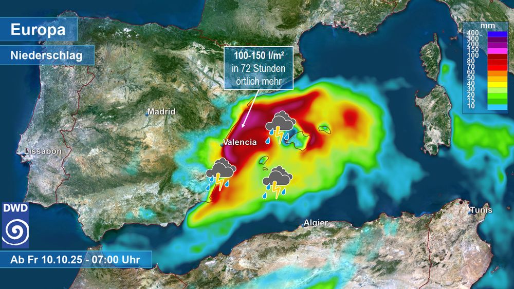
Vom Wettermodell ICON berechnete 72-stündige Niederschlagsmengen im Bereich des westlichen Mittelmeers, beginnend am Freitag, 10.10., 7 Uhr.
Blick zum westlichen Mittelmeer: DANA "Alice" (DANA = Depresión Aislada en Niveles Altos = isoliertes Höhentief) sorgt zwischen Balearen und der spanischen Ostküste seit Tagen für heftigen, gewittrigen Regen - und es kommt noch einiges dazu! Betroffen ist auch die anfällige Region um Valencia. /V
10.10.2025 13:26 — 👍 23 🔁 8 💬 1 📌 1
#Omega style blocking pressure pattern developing
UK dominated by high pressure as rain bearing weather systems steered well away

"Hurricane #Humberto to batter Britain"... not quite as simple as that.
Notwithstanding if it were to reach the UK it would be Ex-Humberto, the deep low that arrives at the weekend may contain some portion of Humberto but actually spawn from a completely different initial low.

Sehr unterschiedliche Regenmengen gab es in diesem September. Im Südwesten war es sehr nass. In Freiburg fielen schon 189 mm, im Norden wie in Hannover gerade mal 32 mm. In den nächsten Tagen wird sich daran auch so gut wie nichts mehr ändern. /LD
28.09.2025 11:36 — 👍 12 🔁 2 💬 1 📌 0Now a Category 4, #Gabrielle's satellite presentation continues to improve. Great time to watch the mesoscale loop as the sun goes down!
22.09.2025 19:02 — 👍 54 🔁 9 💬 1 📌 0
Ein Höhentief über Frankreich bringt bis Donnerstag dem Südwesten und teils auch der Südhälfte immer wieder mal Regen. Nach dem ECMWF können teils über 100 mm fallen. Der große Norden bleibt häufig trocken. /FR
21.09.2025 20:12 — 👍 16 🔁 3 💬 0 📌 0
Christians 4 future: Protect creation!
20.09.2025 14:13 — 👍 1 🔁 0 💬 0 📌 0
Demonstration für Klima- und Menschenschutz in Mainz -
Protect climate und humans! Protest today in Mainz

Rainbow over Rhine river:
12.09.2025 18:57 — 👍 1 🔁 0 💬 0 📌 0
Extremregen in NRW mit lokal über 150 mm
Das ist jetzt die Regenbilanz in NRW mit einem Extremereignis zwischen Bedburg und Mönchengladbach. Hier sind 100 bis örtlich über 150 mm gefallen. Für Details in Städte/Kreise. 1/3

UPDATE: Official 12-hourly precipitation data, 09/09/25, 6 UTC. Highest amounts:
Bedburg (Germany) 134 mm
Luxembourg Airport 122 mm
Mönchengladbach (Germany) 122 mm

Mondfinsternis über dem Rhein bei Mainz.
Lunar eclipse in Mainz on Rhine.

Caryopteris in my backyard in Mainz city are heavily visited by bees and bumblebees this warm weekend!
07.09.2025 16:26 — 👍 1 🔁 0 💬 0 📌 0
Das ID2 Modell sieht weiterhin die schärfste Lage am Dienstagmorgen mit unwetterartigem Starkregen im Westen. Lokale Explosionen bis 200 mm sollten aber erstmal nicht überbewertet, aber beobachtet werden bis morgen. Modell-Update alle 3 Stunden. /FR
07.09.2025 13:51 — 👍 40 🔁 13 💬 0 📌 1

Das Regengebiet ab der Nacht auf Dienstag in zwei neuen Wettermodellen. Da Gewitter eingelagert sein können, ist punktuell auch mehr möglich. Hier zu den Modellen:
kachelmannwetter.com/de/modellkar...
/FR

I was shocked when I first saw these results from standard climate models used in IPCC reports: for high emissions, the Atlantic overturning circulation #AMOC shuts down in all 9 models that ran past 2100, and is well on the way to shutdown by 2100.
Our paper on that is out today.🧵
Here’s a 48-hour water vapor loop of Ex-Hurricane Erin spinning on its final approach to Europe. Truly mesmerizing.
26.08.2025 10:58 — 👍 167 🔁 55 💬 4 📌 7
🔴⚠️🔥🇪🇸🇵🇹In the first cloud free day the view over N. Spain & Portugal is dramatic:burn scars span from Galicia to Extremadura & CastillayLeón down to Portugal, with hotspots still present.⬇️#Sentinel3 📸 of Aug.22 with FRP from eumetview. Wildfires #ClimateEmergency
23.08.2025 11:06 — 👍 27 🔁 14 💬 1 📌 0
No surprise. Mass tourism got out of hand.
www.theguardian.com/business/202...
Im Laufe der nächsten Woche wird der ehemalige Hurrikan ERIN als sattes Tief das Wetter in Mitteleuropa bestimmen. /LD
22.08.2025 12:36 — 👍 50 🔁 7 💬 1 📌 0