IEMBot Image TBD
A STRONG THUNDERSTORM WILL IMPACT CENTRAL LOS ANGELES COUNTY THROUGH 230 AM PST [wind: 40 MPH, hail: 0.00 IN] for Eastern San Fernando Valley, Eastern Santa Monica Mountains Recreational Area, Los Angeles County Beaches, Los Angeles County Inland Co... Link
21.11.2025 09:45 — 👍 1 🔁 2 💬 0 📌 1

FFWLOX
The National Weather Service in Los Angeles/Oxnard has issued a
* Flash Flood Warning for...
South Central Los Angeles County in southwestern California...
* Until 400 AM PST.
* At 145 AM PST, Doppler radar and automated rain gauges indicated
thunderstorms producing heavy rain across the warned area. Flash
flooding is ongoing or expected to begin shortly. Landslides and
mudslides are possible in the warned area.
HAZARD...Flash flooding caused by thunderstorms.
SOURCE...Radar and automated gauges.
IMPACT...Flash flooding of small creeks and streams, urban
areas, highways, streets and underpasses as well as
other poor drainage and low-lying areas. Landslides
and mudslides are possible in the warned area.
* Some locations that will experience flash flooding include...
Beverly Hills, Culver City, Hollywood, Universal City, Venice,
Inglewood, Santa Monica, Griffith Park, Downtown Los Angeles,
Encino, West Hollywood, Century City, Hancock Park, Hollywood
Hills, Studio City, Bel Air, Marina Del Rey, Brentwood and
Interstate 405 through the Sepulveda Pass.
🚨 Flash Flood Warning issued November 21 at 1:45AM PST until November 21 at 4:00AM PST by NWS Los Angeles/Oxnard CA 🚨
Additional Details Here.
21.11.2025 10:00 — 👍 1 🔁 2 💬 0 📌 0

IEMBot Image TBD
LOX continues Flash Flood Warning [flash flood: radar indicated] for Los Angeles [CA] till 3:00 AM PST Link
21.11.2025 10:03 — 👍 0 🔁 1 💬 0 📌 0

At 203 AM PST, Although rain has lightened, Doppler radar indicates
more showers and thunderstorms will move into the area over the next
couple of hours. Flash flooding is ongoing or expected to begin
shortly.
HAZARD...Flash flooding caused by thunderstorms.
SOURCE...Radar.
IMPACT...Flash flooding of small creeks and streams, urban areas,
highways, streets and underpasses as well as other poor
drainage and low-lying areas.
Some locations that will experience flash flooding include...
Rancho Palos Verdes, Torrance and Rolling Hills.
🚨 Flash Flood Warning issued November 21 at 2:03AM PST until November 21 at 3:00AM PST by NWS Los Angeles/Oxnard CA 🚨
Additional Details Here.
21.11.2025 10:15 — 👍 0 🔁 1 💬 0 📌 0

#Rain #CAwx #LosAngeles
#Rain #CAwx #LosAngeles
15.11.2025 19:35 — 👍 2 🔁 1 💬 1 📌 0

* WHAT...Flooding caused by excessive rainfall is expected.
* WHERE...A portion of southwest California, including the following
county, Los Angeles, specifically Catalina Island.
* WHEN...Until 200 PM PST.
* IMPACTS...Minor flooding in low-lying and poor drainage areas.
In addition, rock and mudslides are possible.
* ADDITIONAL DETAILS...
- At 1152 AM PST, Doppler radar indicated heavy rain due to
thunderstorms. Minor flooding is ongoing or expected to begin
shortly in the advisory area.
- Some locations that will experience flooding include...
Two Harbors and Avalon.
- http://www.weather.gov/safety/flood
Flood Advisory issued November 15 at 11:53AM PST until November 15 at 2:00PM PST by NWS Los Angeles/Oxnard CA
Additional Details Here.
15.11.2025 20:01 — 👍 1 🔁 1 💬 0 📌 0
@lafd.bsky.social has a new Chief, and he is already a friend of the Canyon. Chief Moore will move from OVB to the top spot. Congrats Chief Moore!
25.10.2025 00:33 — 👍 0 🔁 0 💬 0 📌 0
Power outage in several areas of the Canyon. Transformer fire on Wonderland in the 8500 block. Avoid the area. 1139a
22.10.2025 18:39 — 👍 1 🔁 0 💬 0 📌 0
Cliff, Vehicle 10/16/2025 INC#0718 | Los Angeles Fire Department
Cliff rescue in progress at Mulholland & LCB. Avoid the area.
lafd.org/alert/cliff-...
16.10.2025 19:22 — 👍 0 🔁 0 💬 0 📌 0

IEMBot Image TBD
LOX cancels Severe Thunderstorm Warning for Los Angeles [CA] Link
14.10.2025 17:32 — 👍 0 🔁 1 💬 0 📌 0
CHP reporting all lanes of northbound Interstate 5 closed due to flooding in San Fernando Valley #CAwx
14.10.2025 17:58 — 👍 15 🔁 5 💬 0 📌 1

At 1225 AM PDT, severe thunderstorms were located along a line
extending from 10 miles south of Coalinga to 12 miles east of Paso
Robles, moving northeast at 20 mph.
HAZARD...60 mph wind gusts.
SOURCE...Radar indicated.
IMPACT...Expect damage to roofs, siding, and trees.
Locations impacted include...
Pismo Beach...
Arroyo Grande...
Nipomo...
Grover Beach...
Oceano...
and Lake Lopez.
🚨 Severe Thunderstorm Warning issued October 14 at 12:25AM PDT until October 14 at 12:45AM PDT by NWS Los Angeles/Oxnard CA 🚨
Additional Details Here.
14.10.2025 07:30 — 👍 2 🔁 2 💬 0 📌 0

SVRLOX
The National Weather Service in OXNARD has issued a
* Severe Thunderstorm Warning for...
Northwestern Santa Barbara County in southwestern California...
* Until 145 AM PDT.
* At 1238 AM PDT, severe thunderstorms were located along a line
extending from 12 miles northwest of Vandenberg Space Force Base to
16 miles west of Point Conception, moving seast at 15 mph.
HAZARD...60 mph wind gusts.
SOURCE...Radar indicated.
IMPACT...Expect damage to roofs, siding, and trees.
* Locations impacted include...
Santa Maria...
Lompoc...
Vandenberg Space Force Base...
Orcutt...
Guadalupe...
Vandenberg Village...
and Mission Hills.
🚨 Severe Thunderstorm Warning issued October 14 at 12:38AM PDT until October 14 at 1:45AM PDT by NWS Los Angeles/Oxnard CA 🚨
Additional Details Here.
14.10.2025 07:45 — 👍 2 🔁 2 💬 0 📌 0

THE NATIONAL WEATHER SERVICE HAS ISSUED SEVERE THUNDERSTORM WATCH
622 IN EFFECT UNTIL 6 AM PDT TUESDAY FOR THE FOLLOWING AREAS
IN CALIFORNIA THIS WATCH INCLUDES 4 COUNTIES
IN SOUTHWEST CALIFORNIA
LOS ANGELES SAN LUIS OBISPO SANTA BARBARA
VENTURA
THIS INCLUDES THE CITIES OF ARROYO GRANDE, ATASCADERO, CAMARILLO,
EAST LOS ANGELES, GLENDALE, GOLETA, LOMPOC, LONG BEACH, NIPOMO,
OXNARD, PASADENA, POMONA, SAN LUIS OBISPO, SANTA BARBARA,
SANTA CLARITA, SANTA MARIA, SIMI VALLEY, THOUSAND OAKS,
AND TORRANCE.
🚨 Severe Thunderstorm Watch issued October 13 at 11:14PM PDT until October 14 at 6:00AM PDT by NWS Los Angeles/Oxnard CA 🚨
Additional Details Here.
14.10.2025 06:15 — 👍 1 🔁 2 💬 0 📌 0

SCSN | Southern California Seismic Network
For data archive access visit SCEDC
Weekly Earthquake Stats: 14 Sep 2025 - 20 Sep 2025. There were 316 events this week ranging from M -0.24 to 3.58. Check out our weekly playback map and visit www.scsn.org for detailed information. #earthquakes #seismology #SCSN #weeklystats @CaltechSeismo
21.09.2025 20:14 — 👍 1 🔁 3 💬 1 📌 0
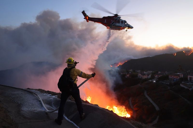
#LAFD responding to report of a Brush fore in the 2100 block of Sunset Plaza Drive. Avoid the area.
03.09.2025 01:54 — 👍 0 🔁 0 💬 0 📌 0

🔥 California’s heat wave means hot, dry, and windy weather—the perfect conditions for wildfires to spark & spread fast.
✅ Secure trailer chains
✅ Skip equipment that sparks
✅ Don’t park on dry grass
✅ No open flames
Let’s stay safe, smart, and fire-aware.
🔗 ReadyForWildfire.org
🔗 HeatReadyCA.com
08.08.2025 19:31 — 👍 31 🔁 20 💬 1 📌 0
NE control in LA is now San Felicia Canyon, about 50 acres slopover. Fixed wing can't get in there, so they are using rotors. 8/7/25 1729 #CanyonFire #LosAngelesCounty #wildfires #CAwx #Piru
08.08.2025 00:29 — 👍 2 🔁 2 💬 0 📌 0
Air Attack has requested 4 additional air tankers, any type. 8/7/25 1607 #CanyonFire #LosAngelesCounty #evacuations #wildfires #CAwx #Piru
07.08.2025 23:08 — 👍 1 🔁 3 💬 0 📌 0
Fire is now 600 acres per incident command. 8/7/25 1506 #CanyonFire #LosAngelesCounty #VenturaCounty #evacuations #wildfires #CAwx
07.08.2025 22:07 — 👍 3 🔁 2 💬 0 📌 0

Current evacuations in Los Angeles County. 8/7/25 1446 #CanyonFire #LosAngelesCounty #evacuations #wildfires #CAwx
Current evacuations in Los Angeles County. 8/7/25 1446 #CanyonFire #LosAngelesCounty #evacuations #wildfires #CAwx
07.08.2025 21:54 — 👍 1 🔁 2 💬 0 📌 0

Canyon Fire at 8/7/25 1418 #CanyonFire #VenturaCounty #Wildfire
Canyon Fire at 8/7/25 1418 #CanyonFire #VenturaCounty #Wildfire
07.08.2025 21:20 — 👍 5 🔁 2 💬 1 📌 0

...TSUNAMI ADVISORY REPLACES THE TSUNAMI WATCH...
Tsunami advisories mean that a tsunami capable of producing
strong currents or waves dangerous to persons in or very near
the water is expected or is already occurring.Areas in the
advisory should not expect widespread inundation. Tsunamis
are a series of waves dangerous many hours after initial
arrival time. The first wave may not be the largest.
LOCAL IMPACTS... A tsunami capable of producing strong currents
that may be hazardous to swimmers, boats, and coastal structures
is expected. Widespread inundation is NOT expected. However,
damage at the harbors will be possible. Surging water in and out
of harbors and changing water levels can cause boats and docks
to detach from structures. Port San Luis and Morro Bay will be
of particular concern for these impacts, however other locations
anywhere in the Advisory area will be susceptible to impacts
including coastal flooding.
RECOMMENDED ACTIONS...
If you are located in this coastal area, move off the beach
and out of harbors and marinas. Do not go to the coast to
watch the tsunami. Be alert to instructions from your local
emergency officials.
FORECAST TSUNAMI START TIMES...
Port San Luis California, 12:35 AM PDT on July 30.
Santa Barbara California, 12:45 AM PDT on July 30.
Los Angeles California, 01:00 AM PDT on July 30.
FORECAST TSUNAMI DURATION...
Port San Luis California, 20 hours.
Santa Barbara California, 9 hours.
FORECAST PEAK TSUNAMI WAVE HEIGHTS...
Port San Luis California, 2.0 to 3.8 feet.
Santa Barbara California, 0.7 to 1.3 feet.
Los Angeles California, less than 1 feet..
Marine Weather Statement issued July 29 at 8:15PM PDT by NWS Los Angeles/Oxnard CA
Additional Details Here.
30.07.2025 03:30 — 👍 3 🔁 2 💬 0 📌 0

IEMBot Image TBD
TSUNAMI ADVISORY IS IN EFFECT FOR THE FOLLOWING LOCATIONS, ALL COASTAL AREAS OF LOS ANGELESVENTURASANTA BARBARAAND SAN LUIS OBISPO COUNTIES for Catalina and Santa Barbara Islands, Los Angeles County Beaches, Malibu Coast, San Luis Ob... till 2:45 AM PDT Link
30.07.2025 03:43 — 👍 0 🔁 2 💬 0 📌 0

* WHAT...Hot daytime temperatures in the upper 90s up to around 105
degrees.
* WHERE...Calabasas and Agoura Hills, Santa Clarita Valley,
Southeastern Ventura County Valleys, and Western San Fernando
Valley.
* WHEN...Until 8 PM PDT this evening.
* IMPACTS...There is a high risk for heat illness for sensitive
populations including the very young, the very old, those without
air conditioning, and those active outdoors.

* WHAT...Hot daytime temperatures in the 90s up to around 100
degrees.
* WHERE...San Luis Obispo County Mountains and Santa Lucia Mountains.
* WHEN...Until 8 PM PDT this evening.
* IMPACTS...There is a high risk for heat illness for sensitive
populations including the very young, the very old, those without
air conditioning, and those active outdoors.

* WHAT...Hot daytime temperatures in the upper 90s up to around 105
degrees.
* WHERE...San Luis Obispo County Interior Valleys and Southern
Salinas Valley.
* WHEN...Until 8 PM PDT this evening.
* IMPACTS...There is a high risk for heat illness for sensitive
populations including the very young, the very old, those without
air conditioning, and those active outdoors.

* WHAT...Hot daytime temperatures in the 90s up to around 105
degrees.
* WHERE...Eastern San Gabriel Mountains, Eastern Santa Monica
Mountains Recreational Area, Santa Susana Mountains, Western San
Gabriel Mountains and Highway 14 Corridor, and Western Santa
Monica Mountains Recreational Area.
* WHEN...Until 8 PM PDT this evening.
* IMPACTS...There is a high risk for heat illness for sensitive
populations including the very young, the very old, those without
air conditioning, and those active outdoors.
Heat Advisory issued July 10 at 10:34AM PDT until July 10 at 8:00PM PDT by NWS Los Angeles/Oxnard CA
Additional Details Here.
(1/2)
10.07.2025 17:46 — 👍 1 🔁 2 💬 0 📌 0

IEMBot Image TBD
LOX issues Heat Advisory for Calabasas and Agoura Hills, Santa Clarita Valley, Southeastern Ventura County Valleys, Western San Fernando Valley [CA] till Jul 10, 8:00 PM PDT Link
10.07.2025 17:35 — 👍 0 🔁 1 💬 0 📌 0
Probably a sonic boom from Vandenburg Space Force Base.
25.05.2025 05:53 — 👍 0 🔁 0 💬 0 📌 0
Felt a jolt in Laurel Canyon.
25.05.2025 05:50 — 👍 0 🔁 0 💬 1 📌 0

From EMSC
#Earthquake 10 mi NW of Los Angeles (#California) 3 min ago (local time 22:13:45). Colored dots represent local shaking & damage level reported by eyewitnesses. Share your experience:
📱https://m.emsc.eu/#app
🌐https://m.emsc.eu/?id=1778359
03.03.2025 06:16 — 👍 2 🔁 4 💬 1 📌 1
Unofficial bot sharing alerts from NWS Los Angeles/Oxnard CA.
This account is not monitored. Contact @wandrme.paxex.aero if needed.
The California Department of Forestry and Fire Protection. Serving and safeguarding the people and protecting the property and resources of California.
https://linktr.ee/calfire_official
Meteorologist/Software Developer, Lead Developer of FireWxPy & xmACIS2Py & PyClimo. SUNY Oswego Class 2016. My tweets are my own and only represent my views.
Interactive weather map and hurricane tracker.
Get our app 👉 https://zoom.earth/app
Terrestrial-Fire-Forest Ecologist, Conservation Scientist and Principal - Wildwood Consulting LLC. Working on land stewardship projects throughout the Pacific West.
NWS Oxnard/Los Angeles products syndicated by IEMBot. @akrherz.bsky.social is my father.
NWS San Diego, CA products syndicated by IEMBot. @akrherz.bsky.social is my father.
Writing about West Coast weather as a Newsroom Meteorologist at the San Francisco Chronicle
Snow lover, Seattle sports fan, University of Washington graduate
sfchronicle.com/author/anthony-edwards/
Neurodivergent Nerd 🤓🧙🏻♂️🖖🏻✨🔭🚀📸🪸🎮♟️🧑🏻💻🗣️🏳️🌈🏳️⚧️ 💪🏻🇺🇦 🇵🇸☮️🇮🇱
Dog dad 🐕🐶
https://www.threads.net/jdalesocal
Mostly lurking. I was @ai6yrham over there on Twitter. Find my main posts at https://m.ai6yr.org/@ai6yr plus many emergency/disaster/public safety bots at https://m.ai6yr.org/public/local
A full-spectrum life safety agency protecting the City of Los Angeles. To report an emergency, call or text 911. For non-emergency City services, call 311.
LAFDtalk is for casual discussion with the Los Angeles Fire Department. To report an emergency, call or text 911. For city services, call 311.
Husband and father. 40th Governor of California. Former Lt. Governor of California. Former San Francisco Mayor. Personal account.
Official ARISS! ARISS lets students worldwide experience the excitement of talking directly with crew members of the International Space Station via amateur radio, inspiring them to pursue interests in careers in science, technology, engineering and math.
TX disaster response non-profit, connecting neighbors with neighbors. Spontaneous volunteers isn't a dirty word to us.
Over 60,000 rescued since 2017.
www.crowdsourcerescue.org
EarthScope Consortium supports transformative global geophysical research and education. Operator of the NSF National Geophysical Facility. #NSFfunded
Film critic | Writer | Jokester | Gamer
The Film Legacy: https://thefilmlegacy.com
Letterboxd: https://letterboxd.com/vilezero/
The Internet's Observatory: Tracking cybersecurity and digital governance • connectivity and democracy • tools and policy for change • https://netblocks.org