Greetings from Europe.
06.08.2025 08:39 — 👍 1 🔁 0 💬 0 📌 0
@srg-science.bsky.social
Greetings from Europe.
06.08.2025 08:39 — 👍 1 🔁 0 💬 0 📌 0#moodoftheday
05.08.2025 18:26 — 👍 86 🔁 9 💬 1 📌 3
A visible satellite image of North America and the western Atlantic Ocean on Monday afternoon.
Sharp cold front, wildfire smoke, Tropical Storm Dexter, and oodles of convection. Today's satellite is a looker.
04.08.2025 18:34 — 👍 22 🔁 2 💬 3 📌 0Multiple rounds of thunderstorms impacted southern Brazil over the last few days.
04.08.2025 21:35 — 👍 11 🔁 4 💬 1 📌 0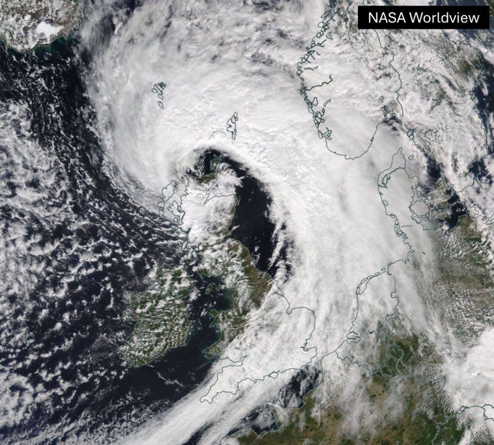
Storm #Floris, an exceptional summer storm 🌀
Provisionally:
- Strongest August gust on record in Scotland
- Equal strongest August gust on record in Northern Ireland
- Lowest August mean sea level pressure in NW Scotland and Orkney since 1992
- Central pressure ⬇️ 28 hPa in 24 hours
A ribbon of thick smoke from Canadian wildfires streams across the skies over North America, sullying the air quality over the Northeast US and Midwest.
04.08.2025 22:38 — 👍 12 🔁 8 💬 0 📌 0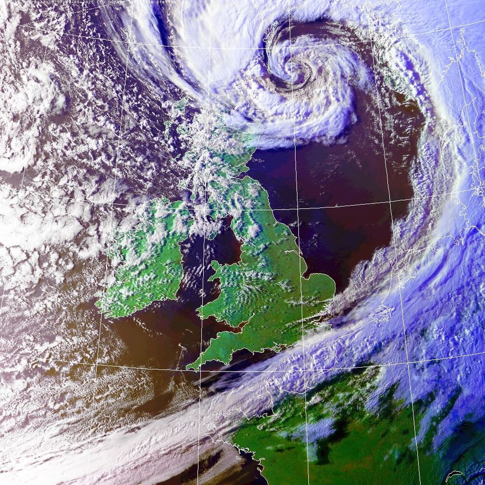
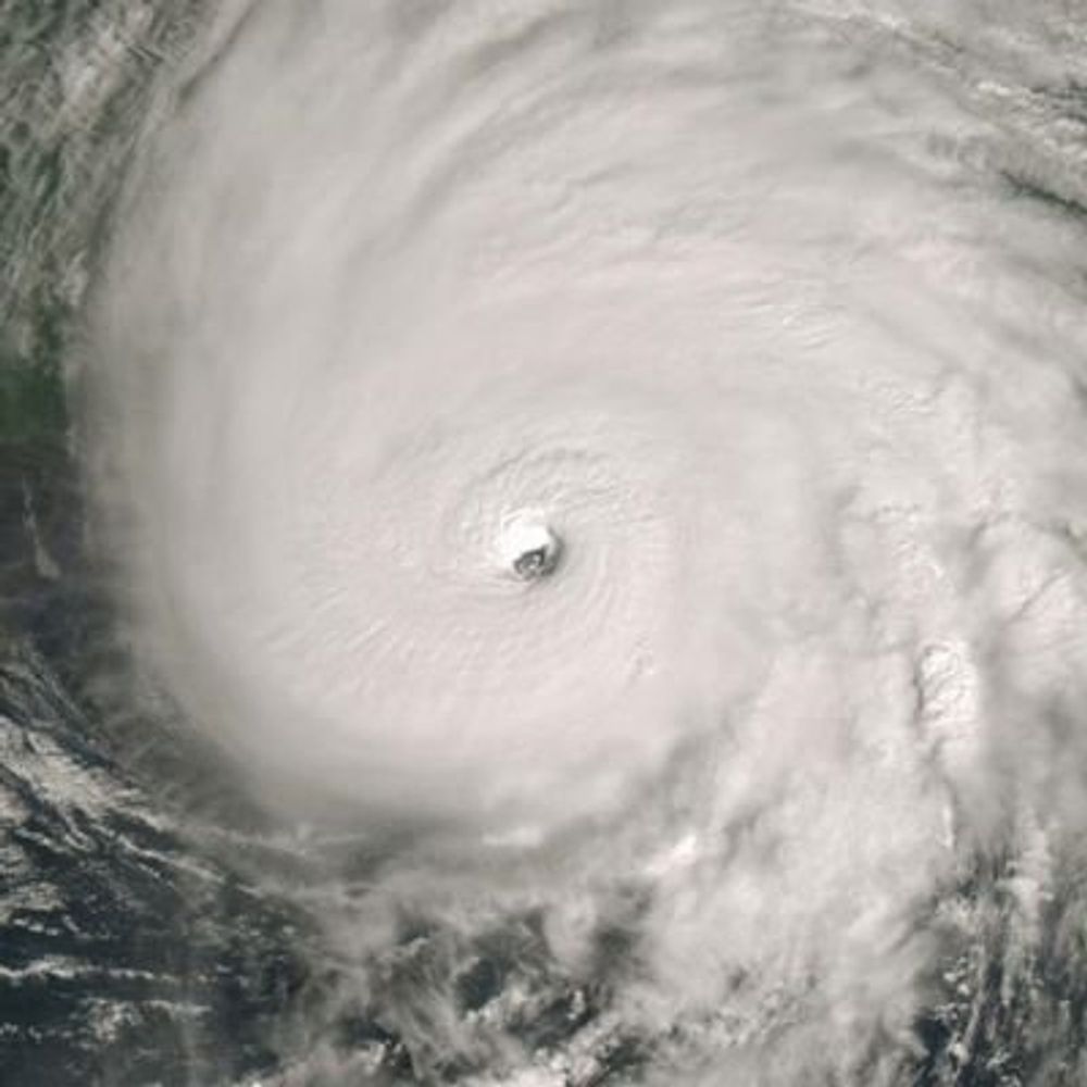
NOAA-15, 1837 UTC Overpass: THE finest view of Storm FLORIS today by any satellite, period. @simonleewx.com
04.08.2025 18:58 — 👍 108 🔁 28 💬 5 📌 2
Kerbi mit einer Gruppe anderer Puppies auf dem CSD Hamburg. Er trägt die Flagge der "Puppies Hamburg". Kerbi with a bunch of other pups at Hamburg Pride holding the flag of the "Puppies Hamburg".
Flagge zeigen beim #CSDHamburg!
Showing flag at #HamburgPride!

🖤💙🤍❤️🤍💙🖤
04.08.2025 22:59 — 👍 0 🔁 0 💬 0 📌 0Da fehlte Netanjahu auf dem Bild.
04.08.2025 22:54 — 👍 1 🔁 0 💬 0 📌 0
Traumhafte Kostüme. #CSD #Hamburg
02.08.2025 12:47 — 👍 62 🔁 14 💬 0 📌 0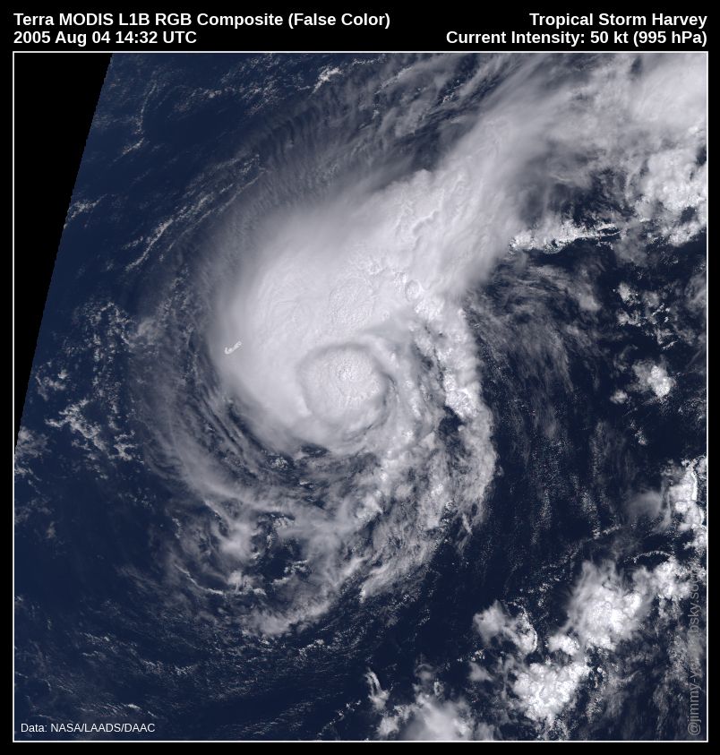
Terra MODIS RGB composite image of Tropical Storm Harvey near peak intensity (50kt, 995hPa) passing ~150 km ESE of Bermuda on 2005 August 4, around 14:32 UTC. The system is compact with a big convective burst occurring near the center and most of the storm activity to the north. Data from NASA.
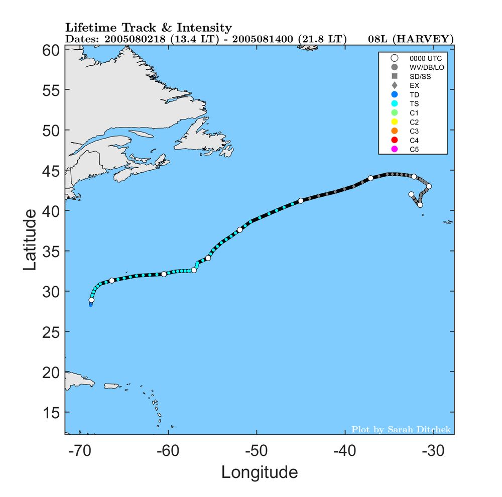
Best track map of Harvey showing a tropical depression forming far east of Florida (~1000 km) and quickly becoming a tropical storm, passing just south of Bermuda, then traveling generally east-northeastward in the open Atlantic. The storm becomes extratropical far from land and eventually dissipates near the Azores. Plot credit Sarah Ditchek, UAlbany.
#wxhistory #OTD in 2005: Tropical Storm Harvey develops in the Atlantic. Harvey reached a peak intensity of 55kt on Aug 4 shortly after brushing Bermuda and causing minor damage. The storm became post-tropical on Aug 8 and its remnants spent the next ~five days meandering in the northern Atlantic.
03.08.2025 10:23 — 👍 5 🔁 3 💬 1 📌 0A large plume of dust swirls over Algeria, captured yesterday by polar-orbiting satellites.
01.08.2025 19:46 — 👍 26 🔁 4 💬 0 📌 1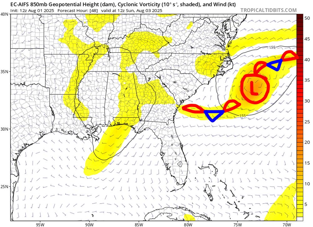
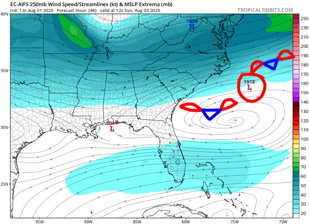
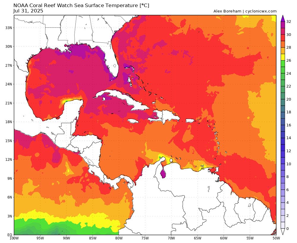
I do believe we should be paying attention to the Gulf Stream over the next few days as a non-tropical low moves off the Carolina's, embedded in a Stationary Front. The low will be under a developing ULAC and over very warm SSTs, not surprised if NHC marks it
#wx
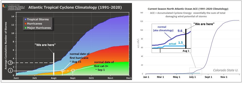
Graphical views of the Atlantic Hurricane season progression as a function of time using two 'metrics'. Normal number of storms by Aug 1 is 3, so we are on-par with normal based on that. But since those storms were weak in terms of wind, we are only about 1/7th the norm to-date
01.08.2025 04:29 — 👍 4 🔁 1 💬 0 📌 0Attention hurricane enthusiasts, connoisseurs, experts: the Atlantic season is entering the active months (Aug-Sep-Oct) so what better time to remind you of this Starter Pack so you can get reliable information and insights!
go.bsky.app/88mXQKD

Von einem Freund bekommen, der gerade in Wacken ist... die Jungs freuen sich jedes Jahr auf die Schlammschlacht 🤣
01.08.2025 10:53 — 👍 220 🔁 21 💬 6 📌 0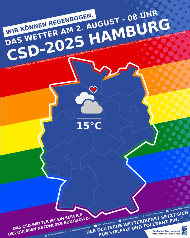
Wettervorhersage für CSD 2025 in Hamburg am 2. August um 08 Uhr; bewölkt, 15°C. Auf dem Bild ist der Umriss Deutschlands vor Regenbogenfarben zu sehen.

Wettervorhersage für CSD 2025 in Hamburg am 2. August um 14 Uhr; sonnig mit Regenschauer, 19°C. Auf dem Bild ist der Umriss Deutschlands vor Regenbogenfarben zu sehen.
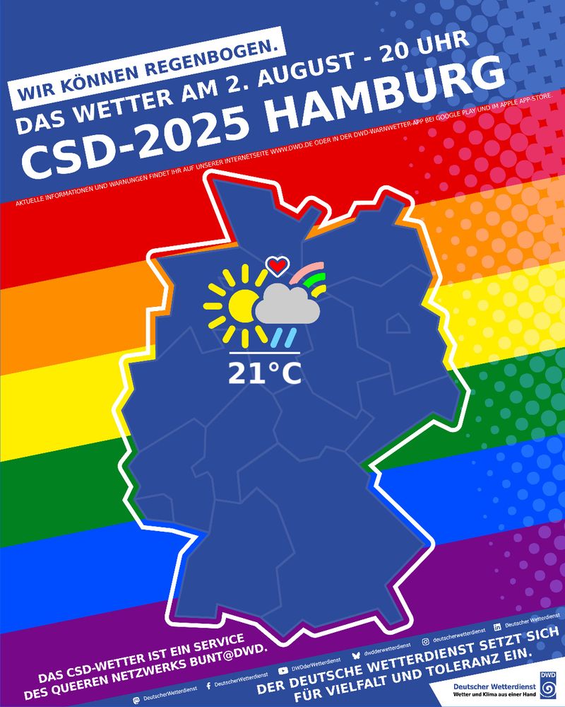
Wettervorhersage für CSD 2025 in Hamburg am 2. August um 20 Uhr; sonnig mit Regenschauer, 21°C. Auf dem Bild ist der Umriss Deutschlands vor Regenbogenfarben zu sehen.
🏳️🌈 Bunt & laut auch bei Schietwetter.
Das #CSDWetter für #Hamburg: Ganztags wechselnd bis stark bewölkt. Ab dem Vormittag Schauer, am späten Nachmittag & Abend einzelne, kräftige Gewitter möglich. 🌡️ Max.temperatur 21 °C.
Das CSD-Wetter: ein Zeichen für Vielfalt & Toleranz. #DuWirDiversity #CSD
Spent way too much time on this but proud with how it came out:
29.07.2025 21:25 — 👍 37 🔁 5 💬 3 📌 0
Iona & Keli.
Iona is the replacement for Iwa (1982).
Keli was last used in 1984.

Working on a project and made this image of the Hunga Tonga volcanic eruption.
Never seen it from this perspective and it sort of blew my mind.
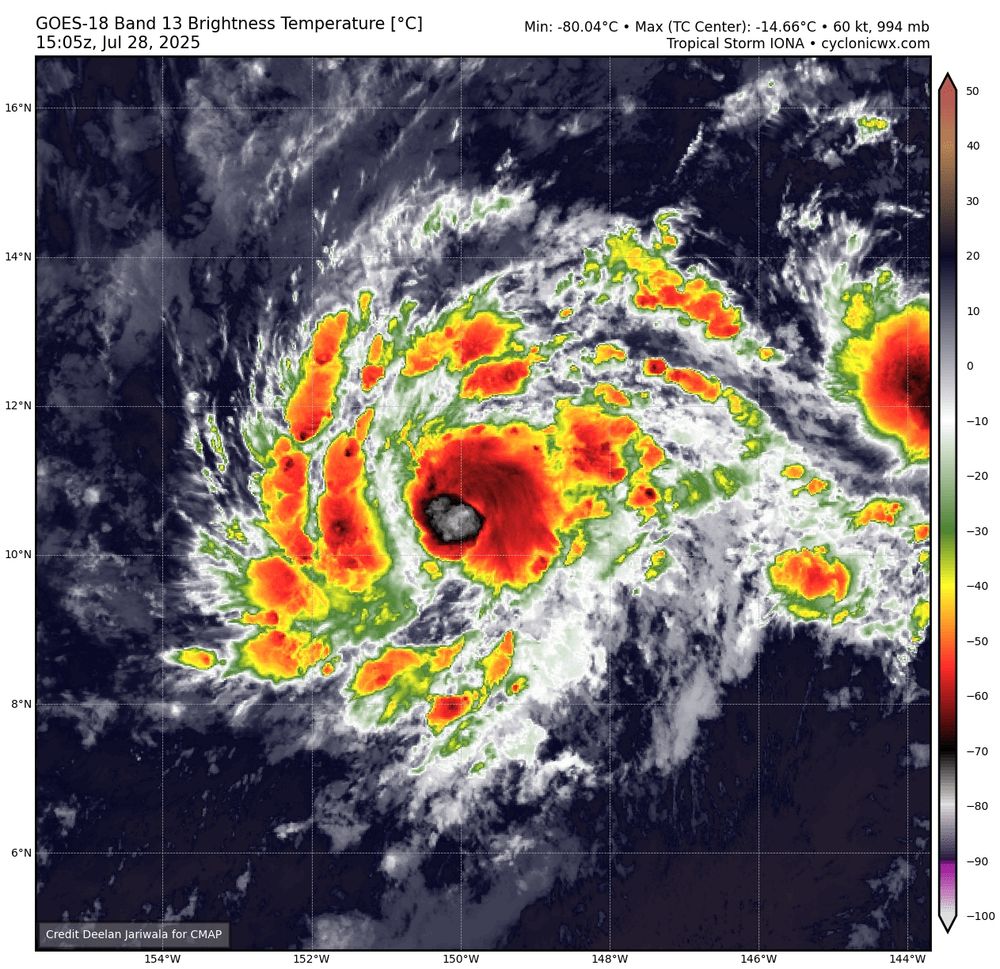
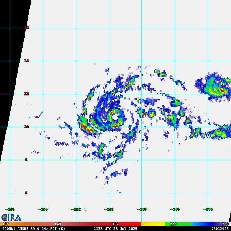
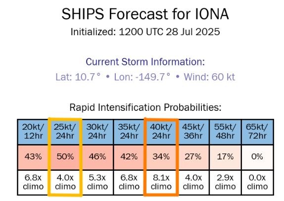

Well we now have #Hurricane #Iona which has developed quite a compact core over the last 18 hours or so! Wouldn't be surprised if this makes a run for major status as Iona is in quite a low shear environment! SHIPS RI probs are up to 34% for a major hurricane!
28.07.2025 15:23 — 👍 1 🔁 1 💬 0 📌 0
Tropical activity in the Atlantic may feel like it's off to a sluggish start this year, but we're actually a few weeks ahead of the pace of an average hurricane season.
27.07.2025 19:56 — 👍 19 🔁 5 💬 0 📌 0NWS Tampa Bay has confirmed this was an actual reading. Pretty insane! Even though Tampa Int’l Airport butts right up to Old Tampa Bay, a steady breeze from the north means there’s no real relief from the water.
Another possible push towards 100°F tomorrow (forecasted high at TPA is 97°F).
I grew up in Tampa and even I’m surprised by this.
27.07.2025 23:01 — 👍 10 🔁 3 💬 0 📌 0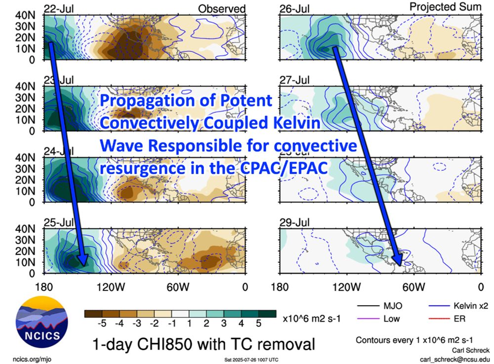
Plot of the western hemisphere showing the filtered Kelvin Wave band (blue solid lines indicate upward vertical motion). Note the wave propagating eastward across from 22 Jul to 29 Jul (following the blue arrow).
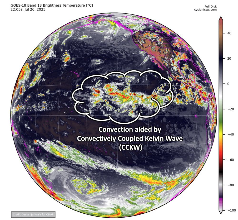
GOES-18 Full Disk View Infrared Satellite Image valid 2205 UTC 26 July. Annotated is the bubble is convection being enhanced by the CCKW.

Graphical Tropical Weather Outlook for 11am PDT highlighting three areas for development.
Not hard to see what is causing the abrupt uptick in convective activity in the Central & East Pacific. A potent Convectively Coupled Kelvin Wave, #CCKW, has been marching eastward, activating the #ITCZ.
This convection may aid #ITCZ breakdown, with 3️⃣ areas being monitored for #TC formation.
Severe thunderstorms erupt near Chicago and over Lake Michigan this afternoon.
24.07.2025 22:36 — 👍 44 🔁 16 💬 1 📌 3Typhoon Co-may nears landfall in the Philippines.
24.07.2025 17:42 — 👍 10 🔁 3 💬 0 📌 017 years ago today:
Hurricane Dolly (2008) exhibited dramatic inner-core structural variability during a 6-hour rapid intensification and deepening event just prior to making landfall in southern Texas at 1800 UTC 23 July.
Related publication: journals.ametsoc.org/view/journal...
On Sunday evening, Typhoon Wipha made landfall in China, bringing heavy rain and strong winds.
This satellite view shows Wipha's evolution over the last four days.