Category 5 Hurricane Melissa made landfall today near Black River, Jamaica with 185 mph winds and is currently re-emerging near Falmouth. If you have the means, I strongly encourage you to consider donating to a relief effort.
Direct Relief: donate.directrelief.org/give/647931#...
(more below)
28.10.2025 21:05 — 👍 45 🔁 17 💬 2 📌 1

The western end of Jamaica where #Melissa is projected to make landfall has the least well-built structures of anyplace on the island. Graphic is from a 2021 paper, "Poverty and hurricane risk exposure in Jamaica": www.researchgate.net/publication/...
28.10.2025 01:53 — 👍 414 🔁 190 💬 11 📌 16
Thanks to some vigilant friends out there, I have a nearly-complete 87-hour radar loop of #Melissa 's approach to #Jamaica. The loop abruptly ends when the radar is lost (either loss of communication with it or loss of the actual structure).
bmcnoldy.earth.miami.edu/tropics/radar/
29.10.2025 12:03 — 👍 293 🔁 104 💬 7 📌 5
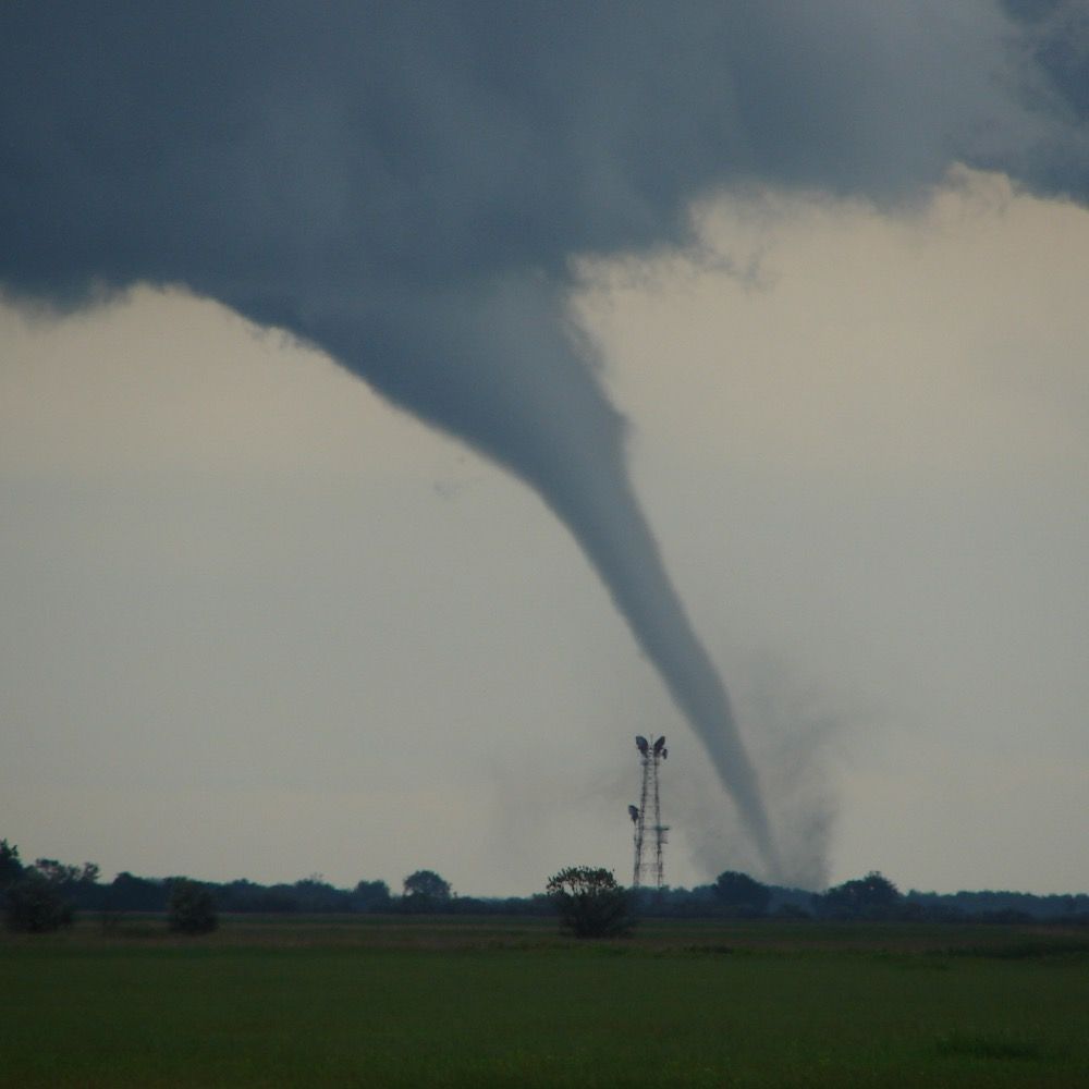
NEW: Devastating imagery from Jamaica, before & after Category 5 Hurricane Melissa.
Black River — near total destruction.
29.10.2025 20:28 — 👍 567 🔁 380 💬 12 📌 30
Thanks for digging into this, Brian! I previously only focused on the peak intensification rate but even the difference in the period from cat-1 to cat-5 is less than 3 hr. This is a surprise but great to know!
06.09.2025 03:20 — 👍 1 🔁 0 💬 0 📌 0

UAH | News | The University of Alabama in Huntsville
Thanks to the hard work of the UAH staff, the press release was successfully synchronized and published live.
www.uah.edu/news/items/u...
09.06.2025 18:14 — 👍 1 🔁 0 💬 0 📌 0
We’ve been waiting for this LES landfall paper for a while. Glad to work with @agitatedcu.bsky.social on this exciting publication, as it sets up the stage for our upcoming NSF WHIRLTC project.
09.06.2025 15:41 — 👍 2 🔁 0 💬 1 📌 0

The Florida state snowfall record appears to have fallen.
From Molino, FL.
Passed along by NWS Mobile.
22.01.2025 00:23 — 👍 154 🔁 42 💬 12 📌 29
Glad to see your TC talk again! Not sure if I see this correctly. Is the track reflection related to the transport of PV, generated by island convection, to the northern TC circulation?
09.01.2025 03:53 — 👍 0 🔁 0 💬 0 📌 0
Is this the one you were waiting for? Congratulations! What a holiday gift!
14.12.2024 00:28 — 👍 1 🔁 0 💬 0 📌 0
Thank you Professor :)
12.12.2024 17:25 — 👍 1 🔁 0 💬 0 📌 0


🌀Our TCBL lab🌀is admitting a M.S. (or Ph.D.) student to study boundary layer winds and tornadoes of landfalling hurricanes from Fall 2025. Students with a strong passion for hurricane science and a strong background of programming/physics are particularly encouraged to apply. Welcome to spread out!
12.12.2024 17:16 — 👍 11 🔁 8 💬 1 📌 1
Associate Professor at the University of Louisville. Specializing in meteorology and severe weather. Enjoyer of bicycles and motorsports.
riding for the feeling
cloud chaser
attorney
KY➡️CO
Wife, mother, cat whisperer. Still trying to figure out what I want to be when I grow up.
Engineer and meteorologist. Alumni of Auburn, NC State, and Mississippi State Universities. US Navy veteran.
Atmospheric Scientist in Monterey, CA
Hurricanes and Arctic Cyclones
🏳️🌈
Princeton University Class of 2027
Majoring in Computer Science/Climate Sciences
Official Bluesky account for NOAA's National Weather Service.
NOAA provides science, service and stewardship to protect life, property & Earth's natural resources. An agency of the Department of Commerce. Join us on Instagram & Facebook. Official NOAA account.
AI for Environmental Science + Science of AI | Dalton Family Chair in Environmental Data Science & Sustainability | Professor of Computing & Data Sciences and of Earth & Environment @ Boston University
Meteorologist - wife/mom - ENTP - reading connoisseur - music lover - STL sports - neurospicy. Thoughts mine, not employers.
Meteorologist |
Director Of The NY State Weather Risk Communication Center @NYSWRCC |
Director of R&D, UAlbany's Center Of Excellence | Affiliated With @nysmesonet
Mostly Weather | Politics & WI Sports #gobadgers | Thoughts Mine
Forecaster. Storm and sky enthusiast. Occasional adult.
forecast.twodogswx.net
https://github.com/adlyons
For Pics &
Youtube.com/twisterkidmedia
For tornado videos
Bad opinions are my own.
I try to "Observe, Reflect and Explore around" in different ways
My posts here will be a mishmash of personal opinions and smol curious excursions..
Cannot jump high, highly motivated by clouds, vector enthusiast, fan of wilderness.
Erie, CO
Current reading: "Indigenous Continent" (Hämäläinen), "Introduction to Quantum Mechanics" (Griffiths and Schroeter)
Meteorologist & car safety systems. husband, father, Chattahooligan. He/him
Retweets are only endorsements if weather. You can like bad weather posts, it doesn't make you a bad person
Atmospheric Scientist. Former Adjunct Associate Professor and Research Scientist, School of Meteorology, University of Oklahoma. LES, dust devils on Earth and Mars, supercells, tornadoes, mammatus, hail, and cloud physics.
Weather and climate scientist focused on extreme events like floods, droughts, & wildfires on a warming planet. www.weatherwest.com
Assistant Professor at Texas A&M University in the Department of Atmospheric Sciences ⛈️
📍College Station, TX
sites.google.com/tamu.edu/nunez-ocasio
PhD Climate Scientist. Alaska. The Earth is warming because of us. Mooseologist. All opinions are my own. Future FIFA Peace Prize winner. Signal: Climatologist.49