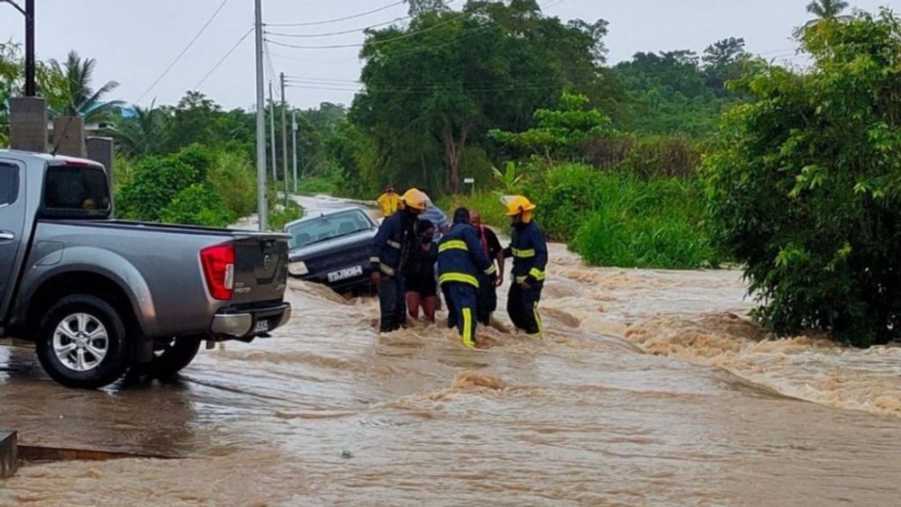
Flooding
Trinidad and Tobago is highly vulnerable to several types of flooding and it has become this country’s most frequent natural disaster.
This activity is being accompanied by gusty winds and locally heavy to violent rainfall, likely to produce street/flash flooding across northwestern areas.
Expect traffic delays and avoid venturing into flooded areas. ttweathercenter.com/flooding/
23.09.2025 17:05 — 👍 0 🔁 0 💬 0 📌 0

1:00 PM - A cluster of thunderstorms moving into north-central and northwestern Trinidad has produced over 300 lightning strikes over the past hour as it moved northwest.
Expect traffic delays and avoid venturing into flooded areas. ttweathercenter.com/flooding/
23.09.2025 17:05 — 👍 0 🔁 0 💬 1 📌 0

Flooding
Trinidad and Tobago is highly vulnerable to several types of flooding and it has become this country’s most frequent natural disaster.
In this activity, localized street/flash flooding is the primary hazard, accompanied by gusty winds and frequent lightning.
If you encounter flood waters, #TurnAroundDontDrown: ttweathercenter.com/flooding/
18.09.2025 18:08 — 👍 0 🔁 0 💬 0 📌 0

2:00 PM - We're keeping our eyes on north-central, northwestern, and west-central Trinidad, where showers and isolated thunderstorms are likely to develop this afternoon after a mostly sunny day.
If you encounter flood waters, #TurnAroundDontDrown: ttweathercenter.com/flooding/
18.09.2025 18:08 — 👍 0 🔁 0 💬 1 📌 0

3:45 PM - Flooding is subsiding along Wrightson Road, Port of Spain, with two of the three eastbound lanes and all three westbound lanes passable.
Significant traffic delays are ongoing across northwestern Trinidad due to residual flooding.
ttweathercenter.com/2025/09/15/a...
15.09.2025 19:52 — 👍 0 🔁 0 💬 0 📌 1

Adverse Weather Alert Now In Effect Only For Western Trinidad
The Adverse Weather Alert is now only in effect for western areas of Trinidad and the Gulf of Paria through 5:00 PM today.
UPDATE: The Adverse Weather Alert is now only in effect for western areas of Trinidad and the Gulf of Paria through 5:00 PM today.
Showers and thunderstorms are already producing street and flash flooding across parts of San Fernando and Port of Spain.
ttweathercenter.com/2025/09/15/a...
15.09.2025 18:12 — 👍 0 🔁 0 💬 0 📌 0

Another Adverse Weather Alert In Effect For T&T Today
Another day, another Adverse Weather Alert for T&T, now in effect through 5 PM today as heavy showers and thunderstorms are forecast.
Locally heavy rainfall, particularly across western Trinidad, may produce street/flash flooding, accompanied by gusty winds. Due to relatively saturated soils, landslides are also possible in elevated areas.
Read more: ttweathercenter.com/2025/09/15/a...
15.09.2025 16:38 — 👍 0 🔁 0 💬 0 📌 0

Over 400 lightning strikes have been detected across and in the vicinity of T&T over the last hour. A strong thunderstorm is ongoing across north-central Trinidad, producing frequent lightning and violent rainfall rates.
ttweathercenter.com/2025/09/13/a...
13.09.2025 16:31 — 👍 1 🔁 0 💬 0 📌 0

Adverse Weather Alert Issued For T&T. Severe Impacts Possible
An active tropical wave is moving across the Lesser Antilles, producing impactful showers and thunderstorms across the region, including T&T.
An active tropical wave is moving across the Lesser Antilles, producing locally strong thunderstorms.
For T&T, locally intense rainfall is likely, which may produce street/flash flooding, accompanied by gusty winds and frequent lightning.
Details: ttweathercenter.com/2025/09/13/a...
13.09.2025 16:20 — 👍 0 🔁 0 💬 1 📌 0

Adverse Weather Alert Issued For Trinidad. Severe Impacts Possible
Locally intense rainfall is forecast across the parts of Trinidad on Friday, according to the TTMS, leading to a severe Adverse Weather Alert.
Although forecast models have backed off strong shower and thunderstorm activity today, the TTMS is forecasting a medium chance of locally intense rainfall across parts of Trinidad on Friday, leading to a severe Adverse Weather Alert.
ttweathercenter.com/2025/09/12/a...
12.09.2025 14:08 — 👍 0 🔁 0 💬 1 📌 0
Flooding
Trinidad and Tobago is highly vulnerable to several types of flooding and it has become this country’s most frequent natural disaster.
Through the afternoon, additional showers and isolated thunderstorms are likely, initially favoring eastern, northwestern, and hilly areas of Trinidad. Conditions are forecast to gradually settle into the evening.
If you encounter flood waters, #TurnAroundDontDrown: ttweathercenter.com/flooding/
11.09.2025 18:08 — 👍 0 🔁 0 💬 0 📌 0
2:00 PM - Isolated thunderstorms and moderate to heavy showers continue to interrupt hazy and mostly sunny skies primarily across Trinidad.
Locally heavy rainfall has led to short-lived street flooding across parts of northwestern Trinidad.
ttweathercenter.com/flooding/
11.09.2025 18:08 — 👍 0 🔁 0 💬 1 📌 0
Flooding
Trinidad and Tobago is highly vulnerable to several types of flooding and it has become this country’s most frequent natural disaster.
With a high tide coming in at 5:45 PM, and it is a spring tide (higher-than-usual) high tide, runoff will be slow. As a result, street/flash flooding is likely, particularly in Port of Spain.
Expect traffic delays on your evening commute out of the capital.
ttweathercenter.com/flooding/
10.09.2025 19:37 — 👍 0 🔁 0 💬 0 📌 0

3:30 PM - Isolated heavy showers are ongoing across northwestern and southwestern Trinidad this afternoon, with violent rainfall rates being detected across Port of Spain and environs.
ttweathercenter.com/flooding/
10.09.2025 19:37 — 👍 0 🔁 0 💬 1 📌 0

Active ITCZ Forecast To Affect T&T
An active ITCZ is forecast to bring impactful weather primarily to Trinidad from this morning, with the risk of flooding, landslides, and gusty winds.
Cloudy skies, scattered showers, and thunderstorms with locally intense rainfall are in the forecast today.
There is an elevated potential for localized street/flash flooding, particularly across Trinidad.
Details: ttweathercenter.com/2025/09/06/a...
06.09.2025 06:41 — 👍 0 🔁 0 💬 0 📌 0

TTMS Issues Adverse Weather Alert For T&T
An active ITCZ is forecast to bring impactful weather primarily to Trinidad on Saturday, with the risk of flooding, landslides, and gusty winds.
An active ITCZ is forecast to bring impactful weather primarily to Trinidad, with the risk of flooding, landslides, and gusty winds.
The alert will take effect at 5:00 AM for Trinidad and Tobago, and remains in effect until 5:00 PM today.
Details: ttweathercenter.com/2025/09/05/t...
06.09.2025 06:25 — 👍 0 🔁 0 💬 0 📌 0

Adverse Weather Alert Extended Until 9 PM For T&T
Localized flooding, due to thunderstorms that are weakening, is ongoing across parts of Trinidad, with the Adverse Weather Alert extended till 9 PM.
This thunderstorm is weakening as it moves southwestward into the Gulf of Paria, likely creating choppy seas, after dumping heavy rainfall across parts of Couva, Point Lisas, and California, leading to street flooding.
Details: ttweathercenter.com/2025/08/24/a...
24.08.2025 21:18 — 👍 0 🔁 0 💬 0 📌 0

Between 4:15 PM and 4:45 PM, an isolated severe thunderstorm in the Gulf of Paria and along west-central Trinidad has produced 420 lightning strikes.
This activity is due to Invest #99L's influence on the atmosphere across the area.
ttweathercenter.com/2025/08/24/a...
24.08.2025 21:18 — 👍 0 🔁 1 💬 1 📌 0
Adverse Weather Alert Extended Until 9 PM For T&T
Localized flooding, due to thunderstorms that are weakening, is ongoing across parts of Trinidad, with the Adverse Weather Alert extended till 9 PM.
The Adverse Weather Alert has been extended until 9:00 PM for Trinidad and Tobago.
Locally strong thunderstorms have affected southern and western areas this afternoon as forecast, leading to sporadic reports of street flooding.
ttweathercenter.com/2025/08/24/a...
24.08.2025 21:03 — 👍 0 🔁 0 💬 1 📌 0

3:15 PM - Isolated, slow-moving, heavy showers and thunderstorms are developing across both islands, with isolated thunderstorms favoring western and southern Trinidad, as well as offshore eastern Tobago. Activity is slowly moving from the NE to the SW.
ttweathercenter.com/2025/08/24/a...
24.08.2025 19:21 — 👍 0 🔁 0 💬 0 📌 0

Adverse Weather Alert In Effect For T&T As Tropical Disturbance Stays North
Invest 99L, a well-defined tropical wave that is being monitored by the National Hurricane Center for development, is…
Elsewhere, hot and mostly sunny conditions continue. Across Tobago, scattered showers are ongoing with light to moderate rainfall and occasionally heavy pockets.
An Adverse Weather Alert is in effect for T&T through 5:00 PM Sunday: ttweathercenter.com/2025/08/24/a...
24.08.2025 18:25 — 👍 0 🔁 0 💬 0 📌 0
Univ. of Miami hurricane researcher 🌀 living in New Mexico 🏜.
Husband and dog dad. 🏳️🌈
https://bmcnoldy.earth.miami.edu/
Sr. Hurricane Specialist at NHC 🌀 | Ph.D + M.S. via UAlbany & B.S. via UNCA | Enjoy all kinds of weather 🌤❄️⛈🌪| Thoughts are my own
Associate professor, Atmospheric and Environmental Sciences at UAlbany. Tropical cyclones & severe weather. Occasionally playing hockey, skiing, or paddleboarding.
ASP Postdoctoral Fellow at NSF National Center for Atmospheric Research, studying tropical waves and hurricanes. Meteorologist and T1D. Let’s talk weather!
Professor of Atmospheric Science at
University of Miami, Hurricane Expert, and Weather Consultant at rfqweather.com
Assistant Professor at the University of Miami. Usually discussing hurricanes.
Hurricane Specialist and Storm Surge Expert at Miami's WPLG-TV Local 10 News. Posts my own.
http://linktr.ee/michaelrlowry
Does a lot of stuff with the tropics and not much else. TCs are cool
UM ‘26
PhD student at Hokkaido University (北大), Sapporo, Japan
Hurricane inner-core dynamics & observations, BS/MS UMiami
Aspiring novelist/singer, beach/wildlife lover, concertgoer, aracial, nonbinary🌀📡🎸⛈️☀️🌴🦈🌊🐶📚🎤
“It’s a made-up world with real-life consequences”
Tropical meteorologist, B.S. FSU, amateur web, Python, & GrADS programmer.
Also known as Not Sparta
Associate professor at the University of Arizona. Hurricane mortician. Open science + Python + scicomm + 🐈 enthusiast. Personal account. Occasionally salty. Always tired. Helpful to a fault.
Someone who studied the weather
University of Wisconsin AOS 🇨🇦🇺🇸
Professor and Chair, Department of Atmospheric & Environmental Sciences, The University at Albany. Avid Boston sports fan. Not ready to make nice. #LFG
M.S. student at Colorado State University studying tropical cyclones + airborne radar. B.S. CS + Atmospheric/Oceanic Sciences from UW-Madison.
Also enjoys diving + photography + storm chasing + television + Wisconsin Sports + F1
NWS Meteorologist HGX | 🌀 Hurricane nerd 🌀 | Former Tropical Meteorologist @ StormGeo | M.S. Earth Science w/ Tropical & Mesoscale Meteorology focus UNC Charlotte | B.S. Physics CofC
New to bsky! Seeking other atmospheric science nerds to follow.
Daily tropical newsletter at weathertiger.substack.com. Posts by Dr. Ryan Truchelut, weatherman, inframarathoner, dad, dad-humorist.
Atmospheric Scientist, Science Communicator & Creator
Live on Twitch at night: twitch.tv/weatherdak.
Former Chief, Hurricane Specialist Unit, National Hurricane Center, NOAA/NWS (retired). Mostly weather posts, with occasional forays into grammar and usage, word play, and south Florida sports.
Weather-Climate professor and scientist, Host of Weather Geeks, Forbes Senior Contributor, Alpha, 3xFSU Alum...Tweets and RTs are mine but not endorsements
Scientist at Lamont-Doherty Earth Observatory, Columbia University. Hurricanes, typhoons, climate extreme events. Brazilian living in the US. Tennis fan.